

LongBeachSurfFreak
-
Posts
9,266 -
Joined
-
Last visited
Content Type
Profiles
Blogs
Forums
American Weather
Media Demo
Store
Gallery
Posts posted by LongBeachSurfFreak
-
-
Amazing temp difference at the beach. Up by the board walk, comfortable 60s. Down right next to the water fridged 40s. The wind had just the slightest south component. Still no backdoor western Nassua, but the westerly wind has died to calm.
-
Just now, donsutherland1 said:
Arctic.
Yeah I figured. Backdoors do not have that true deep cold you need. The craziest swings are out on the high plains. Like 80 to -10 in a few minutes…
-
 1
1
-
-
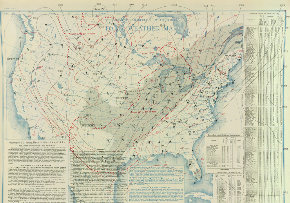
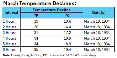
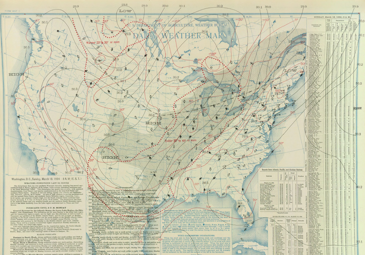
52 minutes ago, donsutherland1 said:
The temperature could fall 20°-25° over a 3-6-hour period later today in New York City. For comparison, below are the records for one-hour through six-hour drops in March:
Would love to know if that was an Arctic front or back door
-
1 minute ago, jm1220 said:
Could be a nasty ice event up there. Temps here around 80 overrunning that cold air. Should be heavy precip. Hopefully temps are 30 with that rain not 25-27, a lot of it runs off when temps are near freezing.
Yeah that should save the valleys where most people live. However above 2000’ feet it’s plenty cold for accretion even with heavy rates. Someone in the southern greens is in for a ruff ride.
-
Warmer outside then it is inside my apartment in Lynbrook currently…
About to head down to Jones Beach. Hoping to catch the BDCF as it wives through.
-
1
-
-
1 hour ago, psv88 said:
84 on Long Island and 22 upstate. Has to be closed to a record gradient for the state.
On the warm end it’s gotta be close. But for actual temp difference, an arctic front setup could easily beat that.
-
24 minutes ago, jm1220 said:
NAM still insisting on a faster backdoor tomorrow afternoon makes me nervous for LI. These very often come in stronger and faster than expected. It’s some very chilly air to our north. Might be one of those where we can literally see the stratus deck come in from the east.
Yeah I have been worried about this all week. I plan on going to the beach tomorrow.
From a meteorological perspective it’s pretty awesome. The last time we saw something similar like 4 or 5 summers ago it was accompanied by a gust front that had 50mph gusts and created a sand storm. It felt like an enormous AC had just went on with the near instantaneous 20 degree temp drop.
And everything was coming from the east, which is opposite of normal. -
20 minutes ago, snowman19 said:
Take the over for Saturday away from the coast
If the flow is straight west JFK will actually be the warm spot for the area.
More likely it’s the warm spot till like 1 or 2. It would take one hell of a westerly flow to completely negate low 40s water temps without the sea breeze eventually winning out. -
5 hours ago, TheClimateChanger said:
Yeah. Hypercanes and adios ice caps. 7c in warming would leave large parts of the earth uninhabitable, that’s the places that aren’t underwater… But C02 is great!!!!
-
 1
1
-
-
15 minutes ago, Feen said:
you think Central Park goes below freezing tonight?
Need some serious CAA this time of year to get the park below freezing. I’d say 35 for the low…
-
 1
1
-
-
Currently in West Hempstead and did not see any snow mix in.
-
48 minutes ago, crownweather said:
For the hurricane season that I released last Thursday, I went with the following analog years - 1895, 1916, 1959, 1967, 1996, 1999, 2008, 2011, 2017 and 2021.
I do think that we may be looking at a East Coast heavy season in terms of threats and potential impacts. The NE Caribbean is another concern of mine as is the central Gulf Coast.
Link to my season forecast - https://crownweather.com/tropical-weather/2025-hurricane-season-forecast/The north east Caribbean is really due for a major. Waters there accumulate heat over the course of years rather then seasons and rely on the upwelling caused by hurricanes for cooling. So essentially that’s an area of virgin OHC. As far as the rest of the Atlantic I think above average ACE is a safe bet. As far as exact landfall locations, I like the SE and gulf again.
-
19 minutes ago, MJO812 said:
Worst news I have heard in years
Don’t worry, the cold pool will send us the back door.
Even if it doesn’t anywhere near the south shore will be significantly colder with water temps still around 40.-
1
-
-
2 hours ago, uofmiami said:
Too early for stronger Bermuda High, Canadian will win out IMO. Probably around 55 for Central Park on Saturday.
Throw in the cold pool off New England and it’s a lock the back door is stronger then expected. I would much prefer the warmth but reality is reality.
-
2
-
1
-
-
18 minutes ago, LibertyBell said:
imagine if it was all snow lol, we'd jackpot
Yeah. This is definitely the snow hole of Long Island. Getting progressively worse as you head south, with Long Beach being the least snowy location.
-
Almost an inch in Sw Nassua with a very presistent band of moderate rain. It’s actually brighter now then it was during mid afternoon.
-
1
-
-
2 hours ago, Dark Star said:
So is this pending Alaskan eruption being overblown? (pun intended)
Looks to be a rather small VEI 4 eruption of a side vent with a recurrence time of 50 years or so. Cool to watch but a very small climate effect. The main cone has a recurrence time of something like 5,000 years and I would think would be much larger VEI 5 or 6.
-
1
-
-
8 minutes ago, Sundog said:
Which storm are you talking about?
It was January of 2010 I believe
-
2 hours ago, LibertyBell said:
We had this storm in February 2010 I think it was-- could have been January 2011 too, don't remember because both those winters were great. We had 5 inches of snow in Lynbrook and Valley Stream and JM in Long Beach was going back and forth with a mix. I remember us watching it on radar too and it clearly showed the mixing line on the barrier islands but it didn't make it up to us.
I’ll never forget that day. I was living in Long Beach and working in new Hyde park. The strangest rain snow line I have ever seen. South of sunrise nothing but white rain, north of sunrise several inches of snow, and it stayed relatively constant up to new Hyde park. Usually the rain snow line sets up along the terminal moraine (northern state)
Meanwhile steady moderate rain continues
-
1
-
-
16 minutes ago, TheClimateChanger said:
Do you think in the absence of human activity, the planet would be destined for a near-permanent ice age in the geological future? Obviously, such an ice age could not truly be permanent, because solar irradiance is increasing over time as the sun is a main sequence star. In the very distant future, this will inevitably lead to runaway warming. But in the nearer term (next few millions of years), it seems likely that ice age conditions would become the norm. In millions of years, could the earth go from near snowball earth conditions to typical quaternary ice age conditions from Milankovitch cycles [rather than from ice age to interglacial]. Looking at the geological record, we can see, generally, a long-term cooling since the Paleocene, which coincides with a long-term decrease in carbon dioxide. This appears to be due to increased weathering and a decrease in volcanism over time. As the earth continues to age, there would continue to be fewer and fewer volcanic eruptions over time, which, in the absence of human activity, would result in continued decreases in carbon dioxide. I wonder if carbon dioxide levels would eventually drop so low that photosynthesis might cease. It looks as though the planetary trajectory is towards extreme cold and eventually extreme heat.
Great post.
I have thought allot about what would happen in the absence of humans. A propensity towards longer harsher ice ages and shorter cooler inter glacial periods would eventually tip the scale in a runaway cooling towards snow ball earth.
The question is what’s left when the suns expantion finally warms the planet enough to melt the ice. Likely single cell extemeaphile life. Which likely wouldn’t have enough time to evolve much further before it’s too warm for any life.-
1
-
-
13 minutes ago, Typhoon Tip said:
It's possible - I don't know Mr Shewchuck's established and/or known biases .. no clue, just using this example - that this was a part of a longer sermon.
C02 is critical to the existence of life on this planet. Without it ... most species cannot exist. How? That's where the Oxygen we need to live comes from.
02 dependent organisms cannot live without C02 --> 02 fixing mechanisms to continuously resupply the O2. Oxygen breathing/metabolizing organisms evolved after this fixing mechanism arrived on the scene, ~ 2.5 billion yrs ago . C02 was here first, however. Virtually all the O2 in sufficient amount to sustain all this bio-diversity ( ..as well as the oxygen used in/for human forced combustion ) since, required the fixing. It owes its ongoing existence to this background exchange between CO2 and O2. O2 cannot otherwise exist in sufficient mass long enough on its own because of it's reactive volatility - look at how fast iron turns to rust.
When raising the mass of CO2 beyond the exchange rate, while maintaining the same amount of incoming energy, the temperature rises with it. When lowering the CO2, the temperature, there temperature thus falls. This critical fact is what keeps this world in an inhabitable temperature range. For this, it is a climate regulator.
So, Mr Shewchuck is right: it enhances the climate.
See where I'm going here? If you stop there, that entire message conveys a marvelous denial manipulation. This is just one way in which miss-representing a source and intent, miss-guides a reader. He may have done this deliberately? Or, he may have been a victim of a redacted repost - in which cast that was not his intent. Either way, we end up with his 'enhancing of the climate' leaving off the following key facet and the whole fucking problem:
It's the part above where adding more CO2 to a planetary system raises the temperature. If needing it spelled out...when exceeding the background CO2 fixing/exchange rate, we end up with a surplus which inimicably creates a surplus in temperature.
That conceptual arithmetic could not be any simpler... And the physics shows 100% causal with zero objective variance. It's amazing how clad it is... God at times even trips over his own creation and has to go, 'shit i can't deny that' it's so clad. The objective physics is that C02 stores energy --> more C02 stores MORE ENERGY. As for those lower educated mouth breather asshole deniers( along with sociopathic leaders that know all this yet don't care or demonstrate any cognitive dissonance to it one way or the other... ), well ... shit - this is probably going to have to end as a slow moving Darwin award.
Obviously I was being simplistic and sarcastic. I think a great analogy for C02 is poking a bear. Bears are beautiful creatures that are extremely important to their habitats. Live and let live and it’s all good.
I am really starting to think that at the higher intelligence end of the denier spectrum it’s turned into a game. It’s just become too incredibly obvious that the planet is warming at an accelerating rate. It’s fun too make up self serving skewed facts, knowing that others will believe regardless of the truth.This really is a can of worms. We could probably spend a week discussing this in person.
-
7 minutes ago, dryslot said:
Dried sea foam.
I lived literally on the beach for years during one of the snowiest periods ever on Long Island and never saw anything like that.
My guess is it something for the soil that’s concentrating on the front of the snow blower. -
7 minutes ago, LibertyBell said:
I bet that's why we get that howling southerly wind as soon as it warms up even a little. It actually felt warmer here because of the lack of wind and I was sitting outside in the full sun this afternoon.
I think the wind is blocked here, aside from a few hours this morning, I haven't noticed the tree branches moving.
I live in Lynbrook too as you know and it the difference between home and the beach was remarkable. Even if it was only a few degrees cooler at the beach, something about the higher dews and of course the wind just makes it feel so raw.
-
1
-
-
53 minutes ago, LibertyBell said:
I mean there's no reason for it to get cold since we have no more arctic shots coming.
I would have thought that CC would have ended these unusual late season cold shots, but I suppose late March is still vulnerable even though the nights are now shorter than the days.
Even a 2c warming isn’t going to end cold shots. Well into April.
One thing to consider this spring is the cold pool formed from upwhelling with all the offshore flow this winter. I was just at jones beach to go for a run and with the wind out of the south it was remarkably cold.
The cold pool to our north east will also have the ability to bring down chilly maritime air anytime we are in a cutoff pattern. Those patterns are common this time of year as the jet slows and retracts.-
2
-
April 2025 Discussion/Obs
in New York City Metro
Posted
Like clockwork almost every year. I have a snowboarding trip planned to VT so I’m ok with this until after that.