

LongBeachSurfFreak
-
Posts
9,297 -
Joined
-
Last visited
Content Type
Profiles
Blogs
Forums
American Weather
Media Demo
Store
Gallery
Posts posted by LongBeachSurfFreak
-
-
54 minutes ago, jm1220 said:
It’s about time for our August deluge. The warm 77 degree waters will give plenty of fuel.
I wouldn’t be surprised at all if someone has a flash flood emergency. Meanwhile it’s the hottest day of the season at the beach. We have had 2 heat stroke incidents with people unconscious.
-
 1
1
-
 1
1
-
-
5 hours ago, psv88 said:
The increased sharks are also eating a lot of the fish…
Saw two sharks fully breach out of the water into the air yesterday within 200 yards of the beach. Had to ban swimming for a while. Bunker pods are active but still much smaller then a few years ago.
Water temps should approach 80 today and tomorrow with light winds and excellent solar heating. That means hot right to the beaches with little sea breeze relief.
-
9 hours ago, LibertyBell said:
we have had plenty of rain, one can argue it's too much rain. This is our first four day period without rain since early June. I only expect or want rain one day per week at most.
I Live in you’re town. Do you drive around?
During the last big rain event you referenced JFK getting 2”. There was a very sharp cutoff at the queens border. We received around an inch total. Since then nearly every convective event has missed. We are sitting in the 1.5” range for the last 30 days. That is in no way sufficient for peak solar insulation. This is a reoccurring theme the last few years. As we seem to rely on convection almost exclusively for summer rain. Our ecosystem developed with more spread out synoptic stratoform rains. Not just convection.
The opinion posts are tiring and a big part of why myself and others post allot less here.I get it you love heat and hate rain in the summer. Move to fuking phoenix and be in you’re glory.
-
 1
1
-
-
6 hours ago, qg_omega said:
I do not need rain
I fixed it for you. Speak for you’re location. This area contains many micro climates. Parts of the east end of the island received .05” during the big New Jersey and lower Hudson Valley flood event. It’s like claiming a region was hit by a hurricane because of a micro burst. Something that is still open to interpretation with colonial weather observations.
-
5 hours ago, GaWx said:
From JB today fwiw: he likes to look at Euro AI ensemble members (ever since that product became available earlier this summer) vs EPS/GEFS and he’s also considering EPS’ MJO forecast: this period is before the increasingly active week that yesterday’s Euro Weeklies showed
Day 15 06 z AI ends like this with a trough in the Tennessee Valley.
and a spray of cyclones suggesting an east coast impact threat
AI VV patterns in the 10-15 are bullish for the tropics
which would mean a stronger rotation into phases 8,1,2,3
more so than the euro ensemble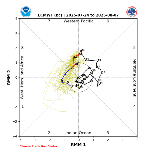
Euro AI relies on pattern analogs. Which Jb loves so I’m not at all surprised he has an affinity for it. To me, it looks dead until the 3rd week of August. Shear and dry air are still lurking.
-
1
-
1
-
-
22 minutes ago, Brian5671 said:
getting to the point where we need a 1/2 to 1 day rainer....nothing in the cards in that dept
Going to need something tropical/sub tropical for that. And it looks dead until at least late August.
-
30 minutes ago, lee59 said:
Not as uncomfortable today as I thought it might be, need rain.
Yeah it’s getting dry. Burned lawns and wilting plants. Pretty par for the course for summer near the coast. Last year was exceptional and second only to the summer 95 Hamptons fire summer drought.
Tomorrow looks good for .5-1” for anyone that gets under good convection. -
1 hour ago, jm1220 said:
If we get a bunch of offshore wind days behind cool fronts, the SSTs will cool down from upwelling. The warm waters here are shallow. But no doubt if we go through Aug with these warm waters we’re asking for trouble-either from a tropical system or stalled out front and MCS deluge like we saw last summer and happens most frequently in August around here.
What the water temps are within 25 miles of the coast has little impact on any tropical activity up here. Because we have some of the longest and shallowest continental shelf in the world. Super shallow water has little to no OHC. That’s why it’s left off OHC maps.
What we need to focus on is the water temps from 50 to 300 miles off the coast. And those waters are less effected by localized upwelling events. Those waters are currently near record warm.
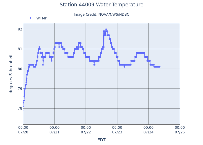
Here’s the Delaware bay buoy
-
1
-
1
-
-
41 minutes ago, Sundog said:
Looks like they tied Somerville at 81 for warmest. LGA had no chance today with the steady NE wind blowing there all day.
Most other places came in at 80.
Makes sense as the instruments are on the east side of the park so the wind was blowing off the densely urban UES.
-
1
-
-
7 hours ago, yoda said:
Pretty much mirrors the sea surface temp profile from earlier. Having the subtropics warmer then the tropics destroys vertical instability in the MDR. The reason they think the season is weighted towards the second half is climatological. Seasonally the subtropics will begin to cool faster then the tropics and return a more normal instability profile.
Last year should have been a wake up call. Warmer water doesn’t automatically mean a hyperactive season.-
2
-
-
Drove through localized flash flooding on the southern state right at the meadow brook. That tiny cell has some insane rates.
-
1
-
-
Central Jersey storm/ff hot spot does it again. Amazingly consistent year after year down there. Meanwhile just showers amounting to a few hundredths on the island.
-
The ridiculous dews are slowing the temp drop. Welcome to the jungle!
-
19 minutes ago, donsutherland1 said:
After clouds broke, it turned hot across the region. High temperatures included:
Bridgeport: 90°
Islip: 90°
New York City-Central Park: 89°
New York City-JFK Airport: 92°
New York City-LaGuardia Airport: 93°
Newark: 95°If today's high of 89° hold at Central Park, today would become the third day this year where all of the above locations except for Central Park reached 90°. That would break the record of two such days that was set in 2006 and tied in 2016.
Tomorrow will be somewhat cooler and a warm and mainly dry weekend will follow.
Additional showers and thunderstorms are possible Sunday evening into Monday morning as a front moves across the region. There is some severe weather and excessive rainfall potential.
Behind the front, it will turn somewhat cooler on Monday. Tuesday and Wednesday should feature bright sunshine, low humidity, and pleasant temperatures mainly in the lower 80s.
No widespread and sustained excessive or record-challenging heat appears likely through the first three weeks of July. However, some of the guidance shows a brief surge of high heat late next week.
The ENSO Region 1+2 anomaly was +0.4°C and the Region 3.4 anomaly was 0.1°C for the week centered around July 9. For the past six weeks, the ENSO Region 1+2 anomaly has averaged +0.52°C and the ENSO Region 3.4 anomaly has averaged +0.07°C. Neutral ENSO conditions will likely continue through the summer.
The SOI was +5.48 today.
The preliminary Arctic Oscillation (AO) was -0.111 today.
Based on sensitivity analysis applied to the latest guidance, there is an implied 74% probability that New York City will have a warmer than normal July (1991-2020 normal). July will likely finish with a mean temperature near 79.0° (1.5° above normal).
Thanks for keeping track of that stat don. It was hot right down to the ocean today.
-
2
-
-
3 hours ago, SnoSki14 said:
Remember when people thought that drought was an issue lol
0.0 here today 1” with the last event. Wouldn’t exactly call it water world on the island. Parts of the east end had .10” last event.
-
3 minutes ago, Volcanic Winter said:
I’ve been so depressed with this unbearable humidity, it’s made being outside at all so unpleasant. I miss the days where hot and humid gave way to storms which gave way to cool and dry.
It’s as if every day is just hot and damp with some amalgamation of sun / clouds / rain / storms. The normal procession of the flow seems completely stagnated.
I really can’t wait for winter - my life for some cool, crisp air.
You’re in the central Jersey severe alley. That comes with allot of convective rain. Out here in the south shore desert I would pay to see the kind of storms you get.
-
30 minutes ago, TWCCraig said:
86/79
These dew points have been absolutely insane. Day after day it's 70+. Floridian humidity on a daily basis
Changed my plans today for water park to big snow. It’s unbearable even for a water park. I was working on my veggie garden this morning and was drenched in sweat in 20 minutes.
-
2
-
-
3 hours ago, LibertyBell said:
if we have a 102 degree heatwave blasting westerly flow right into the ocean shouldn't that heat up the ocean even more?
I feel like the only reason onshore flow heats up near shore ocean waters is because it brings Gulf Stream waters closer to shore?
You’re favorite days, the days when the south shore shoots well over 100 on a strong offshore flow often see brutally cold water temps. Near shore water temps were in the low 60s on the hottest day of the June heatwave with tons of upwelling. Super shock from the system to go from 100+ on the sand to water that chilly.
The Gulf Stream is too far offshore to have any real effect on our waters. It follows the end of the continental shelf. Occasionally an eddy will spin off that gets relatively close.
As far as effects on tropical activity, our exposure to a major is increasing. We have always been able to support a major up to the latitude of the Gulf Stream but then had a nice buffer to weaken storms that weren’t rocketing north like 38. Out waters still technically can’t support a major (allot of it is depth related) but the weaking effects of water around 26c aren’t that pronounced.-
1
-
-
19 minutes ago, Big Jims Videos said:
The ocean temp at Point Pleasant Beach yesterday afternoon was close to 80 degrees. Went for a swim after work. Warmest I've ever felt this time of year. Great flip from the endless upwellings we experienced last summer. Also a bunch of cow nose rays scared folks out of the water before I got there as folks thought they were sharks.
All the gaurds I work with and we have about 1000 years between us are saying it’s the warmest it’s been this early. Usually you get a day or two in the high 70s in August. Unless we see a reversal to strong westerly’s, sustained low 80s are possible in August.
-
3
-
-
3 minutes ago, jm1220 said:
Well we didn’t have the 5-7+ inch totals over NJ and the Hudson Valley, and the radar clearly showed the storms collapsing as they went east of the city. They essentially rained themselves out over LI. August is typically when we have our higher end rain events likely because the waters are warmest then.
The water never gets as warm as the land on a sunny summer day. But as we get later into the summer that effect is less and less pronounced. With less solar insulation and water temps at maximum the sea breeze mechanism is muted. Plus you generally have the highest PWAT potential in August.
-
1
-
1
-
-
46 minutes ago, LibertyBell said:
I'm confused what would cause the weakening though because the oceans are extremely warm now, in the mid 70s.
It’s the sea breeze. You can see the exact thing play out in Florida everyday with water temps there in the mid 80s. It has to do with locally higher pressure over and near the water. As the land heats and warms it creates an area of lower pressure which acts as a focusing mechanism inland. Enhanced convection 30-50 miles inland is exactly what we saw yesterday.
-
3
-
-
50 minutes ago, LibertyBell said:
I dont understand why people thought the cooler ocean would weaken it, it rained for over 12 hours here and we had well over an inch on the south shore. The oceans are much warmer now, the ocean won't be weakening anything anymore, if anything it adds more moisture to make the rain heavier.
It absolutely did. Amounts drop of a cliff east of the queens border. The east end barely saw a shower.
-
South shore getting a nice batch of rain currently adding to the .5” from yesterday. I’ll take it.
-
Nice sunny day at the beach after some morning clouds. Sea breeze is cranking right now. Going to stay dry here as expected.
-
1
-
african wave (0/50)
in Tropical Headquarters
Posted
This has a short to be the first long track Cape Verde hurricane in early August in long time. Genuine east coast threat and prolific swell producer.