

CoraopolisWx
-
Posts
2,960 -
Joined
-
Last visited
Content Type
Profiles
Blogs
Forums
American Weather
Media Demo
Store
Gallery
Everything posted by CoraopolisWx
-

Pittsburgh, Pa Winter 2023-24 Thread.
CoraopolisWx replied to meatwad's topic in Upstate New York/Pennsylvania
Not to go off topic with hyperbole, but even in N/S dominant winters the Alberta Clipper seems to be less frequent than past winters, especially the last 10. Just feel like the 80’s 90’s and 00’s had more clippers, even during lean years. Could just be revisionist history being different from reality. Lol -
Pittsburgh, Pa Winter 2023-24 Thread.
CoraopolisWx replied to meatwad's topic in Upstate New York/Pennsylvania
Saw this on the gfs a few days ago, but didn’t give it a second look. But it could have legs if a logical evolution is being shown by midweek. -
Pittsburgh/Western PA Fall 2023 Discussion
CoraopolisWx replied to Ahoff's topic in Upstate New York/Pennsylvania
The NWS took a bit of an L yesterday. They thought downsloping would hinder any precip development, however with N-NE surface winds, this was not an issue. Usually said winds are SE, or to a lesser extent E. Possibly these Mets relocated here, and aren’t familiar with local climate. Regardless this would’ve been a nice surprise in the winter. -
Pittsburgh/Western PA Summer 2023
CoraopolisWx replied to Ahoff's topic in Upstate New York/Pennsylvania
Wouldn’t mind this setup in the winter. -
Pittsburgh/Western PA Summer 2023
CoraopolisWx replied to Ahoff's topic in Upstate New York/Pennsylvania
Good old fashioned gusty northerly. Line held together longer than I thought earlier. -
Pittsburgh/Western PA Summer 2023
CoraopolisWx replied to Ahoff's topic in Upstate New York/Pennsylvania
Decent storm rolling through the South Hills. -
Pittsburgh/Western PA Summer 2023
CoraopolisWx replied to Ahoff's topic in Upstate New York/Pennsylvania
Definitely an unusual start to met summer. This dry back door cold front pattern would be more useful with a strong STJ in the winter. -
Pittsburgh/Western PA Spring 2023 Discussion
CoraopolisWx replied to Ahoff's topic in Upstate New York/Pennsylvania
Anyone getting any mixed precip ? -
I think most of us here have a common bond through weather/physical science in general, with varying degrees of preference. As long as we respect each others opinions it's all good. Sometimes feeling/intent doesn't always translate through the typed word.
-
Then you can stay in your Spring thread, unless you have something useful to post in the winter thread.
-
If it only rained, long range model verification would be 95-100%. Oh wait... SMH
-
3 NNE Worcester AP 23.0 in 1211 AM 03/15 Templeton 23.0 in 0643 AM 03/15 Trained Spotter 1 NE Fitchburg AP 19.4 in 0609 PM 03/14 Public Phillipston 19.0 in 0400 PM 03/14 Amateur Radio Holden 0.9 SSE 19.0 in 0530 AM 03/15 COCORAHS Barre 1.4 NNE 17.2 in 0700 AM 03/15 COCORAHS Worcester AP 14.4 in 1108 PM 03/14 Significant H9 variance.
-
Looks like a solid band about to move in.
-
Classic blustery NW flow day. Refreshing.
-
In the river valleys, it’s possible.
-
I’m still keeping an eye on next weekend. (And the rest of the month). Although the OP’s have pivoted to a far NW solution, not all is lost yet based on a few red tagged comments I’ve seen in other threads.
-
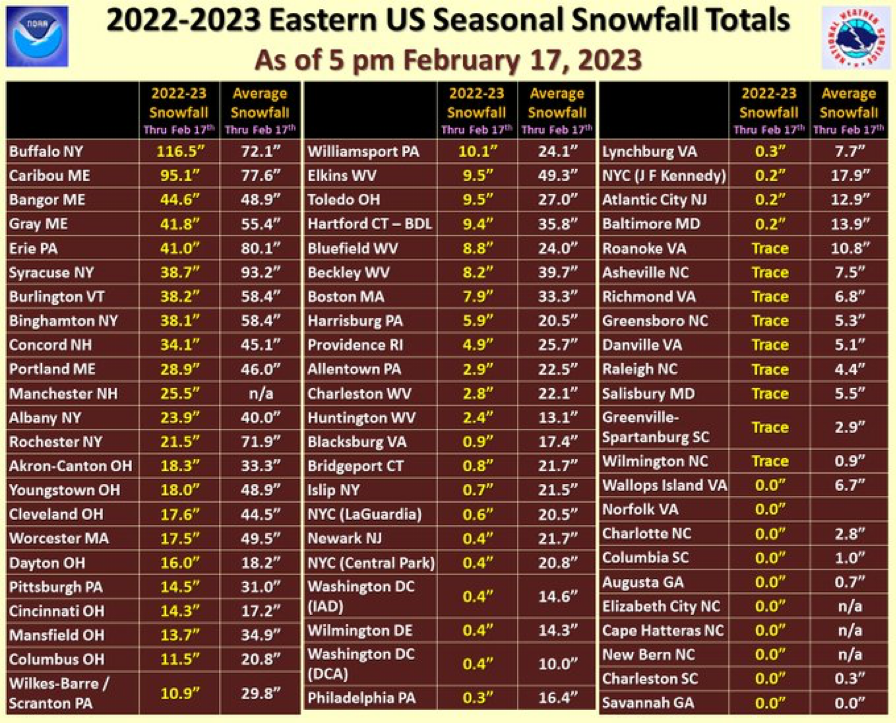
After a quick look at all the Feb. snow totals, 0.2" should be the new record.
-
There’s some monster deficits on that list. SMH
-
Sneaky 71 at AGC last hr.
-
We finally got a vort to dig further south for the weekend, it’s just too far south. Unfortunately with no blocking it goes ots.
-
The GFS, CMC, and Euro. I just mentioned the Euro, because it tends to lead the way with these types of storms.
-
Would like to see the Euro start to get onboard soon though.
-
nice winter scene earlier
-
The big 3 are all showing potential for next Saturday. The GFS finally has a vort digging into the mid south, allowing for earlier development.
-
A new lake will form just west of Steubenville, helping to boost that areas economy, and provide us with much needed LES. Lol

