

dta1984
-
Posts
1,698 -
Joined
-
Last visited
Content Type
Profiles
Blogs
Forums
American Weather
Media Demo
Store
Gallery
Posts posted by dta1984
-
-
Picked up .75" throughout the day yesterday. The lake effect that did form mostly stayed to the south west.
Looks like a rather boring next week or so. Good news is that hopefully any more ice build up in the western basin will be halted.
While we have missed a few good lake effect bands around here, this December is far better than the past few years.
-
7 minutes ago, NEOH said:
35/35 Imby. Looked like under an inch of snow last night... But there was a glaze on top. What an awful "storm".
What a raw day. Temps definitely underperformed. Snowpack still holding on and will be a glacier later today. Hoping for a few inches tonight /tomorrow.
-
Ohweather...what are your thoughts tomorrow night and Sunday for snow? Cle mentions a general 1-3 for both periods.
-
In mentor right now and it's snowing pretty good. I'll see if I can bring this band south a little when I come home !
-
It'll be interesting to see what happens tomorrow night and into Saturday. Does the deep snowpack help us hold the cold air longer? Looks like cle going with 2-4" overnight tomorrow.
-
15 minutes ago, NEOH said:
Its moving pretty fast to the NE now. Snowing hard in Chagrin Falls. Looking at the visible satellite you can see the bands over the lake pushing to the NE from the SW. Ridging coming in this soon? This band may head all the way up the lakeshore if it continues on this pace.
Thanks for the radar link!
Ya we need this band to stall where it is now. It was definitely racing NE fast.
-
46 minutes ago, NEOH said:
Congrats all. Nice spread the wealth. Measured 5" so far. The meso models are showing a decent amount of precip to come... the nam handled this event pretty well so far although all were too far north with the band placement. We'll see what today brings. If the nam and wrf models are correct we are looking at .30 to .75.
Even with the strong winds the highest totals have fallen close to the lake.
Ya hopefully we can cash in when everything swings north....slowly .
There's probably 8" in Solon. Roads are a mess still.
Anyone have a link to a good radar? I can't get the one on wunderground website to work.
-
4" here. Not snowing right now.
Wow congrats Trent!
-
1 hour ago, NEOH said:
Wow that band is just awesome. I can barely see across the street. Can't ask for a better fetch across the lake. It looks pretty much stationary for now.
Looks great! Those short term runs turned out to be pretty accurate.
It looks to be ripping really good by Trent !
-
Fantastic ohweather! Should be a fun spread the wealth event. I'm definitely hoping that heavy band doesn't set up so far north again though.
-
12 minutes ago, NEOH said:
Noticeable shift south with precip on the 18z run. Reminderville jackpot
") . If there is a SW bias its good to be on the north side. Check out Lake Huron... those areas would be buried.
. If there is a SW bias its good to be on the north side. Check out Lake Huron... those areas would be buried.
Check the 4km NAM on tropicaltidbits. It also loOKs good.
-
55 minutes ago, Trent said:
That's pretty much an ideal run for most of us on here. Let's hope it verifies.
Haha that's true, covers most of the posters!
-
1 hour ago, NEOH said:
Here's total precip...
Wow let's lock that in!
Similar band placement to the DEC 2010 one that dumped on downtown out to Solon during the day.
-
11 minutes ago, NEOH said:
Just checked bufkit and winds do come around on the NAM primarily from a 280 wind direction... for quite some time. While the GFS brings winds around from 290 - 300 for extended period of time. I think the big difference between this event and last week is there won't be a trough stalling over the lake preventing the winds from turning.
Definitely good news !
Out of curiosity . ...what causes some events to be a single dominant band (like last week) vs a more multi band setup?
-
Les watch out. Cle mentions w then wnw winds. Hoping for a little more n wind than last time.
-
3 hours ago, NEOH said:
I wonder what the next round of LES this week will bring. For those of who missed the last event hopefully the winds have a more NW component. Strong winds and dry arctic air usually are great for heavy LES but BUF seems to be on board with a significant event.
Cle mentions this in a hwo and also discussion . 3-5" + seems their early guess. Really hoping we get something to set up a little further south this time.
-
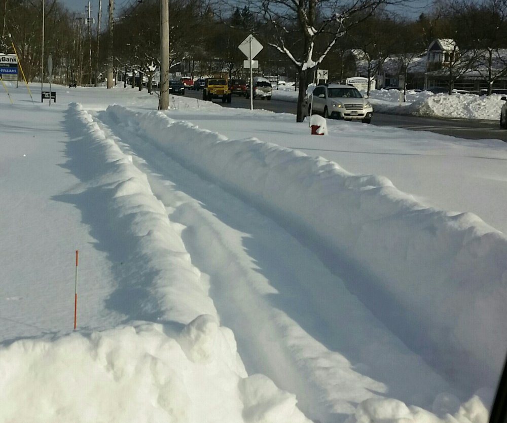
I'm going with a 6" storm total. There was more accumulation after my last measurement , but definitely melted quite a bit.
-
Took another measurement because I'm sure it will be compacted pretty good by morning . 3" additional , storm total at 5.5".
-
6 minutes ago, NEOH said:
it's dumping right now. Mix line is slowly pushing north. Not sure how far north it will make it.l
Some impressive returns to the south west! Hoping we can hold on to snow. 28 according to wunderground.
-
2.5" so far as the dry slot moves in. Hrr still shows 4-6" more later.
-
1 hour ago, NEOH said:
Hopefully we'll see an uptick in the snow intensity. Nice all day snowfall though. It will interesting to see how far north the dry slot and warmer air can make.
Intensity has picked up the past hour or so. Looks like a small dry slot headed this way.
-
1.5" so far. Seems on track. Light steady snow so far.
-
9 hours ago, OHweather said:
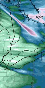
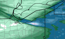
I'm going to make a map of observed snowfall from this lake effect event based on reports and radar. If any of you have amounts to report from NE OH or NW PA that you haven't posted already, please do post them so I can include them.
The January 17-19th event last winter also had a swath of 2 foot totals in a similar area as this event...although I believe this event had a larger 2'+ area east of Cleveland and had higher max amounts...still trying to figure out if anyone officially broke 3 feet. I'm almost certain a couple spots tickled that number, but a spotter report of it would be nice.
While I didn't measure anything ....I will say the jackpot was definitely around route 6 in Kirtland . Driving on 306 a few miles north of 322 the snow picked up considerably passed Wilson mills. Once you get to the high school in Kirtland , it did seem to drop off....still 12"+ though . Mentor Avenue area was probably between 8-12". The southern edge was not far from here. Washington St probably only 1".
-
Just came back from Chardon. Easily 18" or so there. Snow quickly increases once you cross into Chardon on Auburn a few miles south of 322. Up until there, a general 3-6".
Northern Ohio Obs/Discussion Part 2
in Lakes/Ohio Valley
Posted
Yep OHweather under the good band !
Light to mod snow here now, nothing too impressive. Just got home and missed the thundersnow.