

dta1984
-
Posts
1,734 -
Joined
-
Last visited
Content Type
Profiles
Blogs
Forums
American Weather
Media Demo
Store
Gallery
Posts posted by dta1984
-
-
1/2" here. Was near Chesterland and Chardon yesterday and suspect an inch, maybe two there. Possibly more in far north geauga. The bands seemed to move too quickly to accumulate much.
-
35 minutes ago, blackrock said:
I forget...when did you guys have your first lake effect event last year?
Last year was late..... first week of December I believe.
-
 1
1
-
-
Both morning wrfs have a 4-6" band, but in different locations. ArW in southwest cuy, and Nmm is through southeast cuy and Geauga.
-
Ya noticed GFS may be caving. Maybe we'll still get something. The short range models should be interesting.
-
Looking forward to at least a chance of accumulating snow this weekend.
HWO from Cle.
DAYS TWO THROUGH SEVEN...Wednesday through Monday.

A strong cold front will move through the area Saturday. Cold air
will sweep in across Lake Erie likely producing lake effect snow that
will last from late Saturday into Monday. Accumulating snow should
be expected.
-
Huron band swinging through. Maybe a quick 1/2".
-
Yep, feels good to be back into winter mode and see an ohweather forecast! We're lucky to have him! Sure is going to feel like winter the next few days. Will be nice to see some flakes.
-
2
-
-
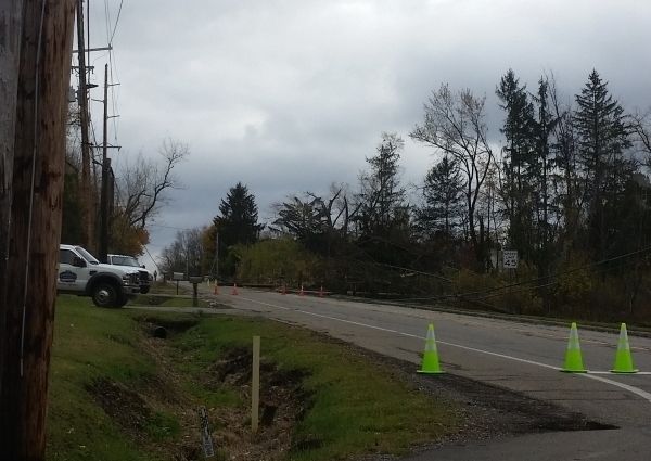
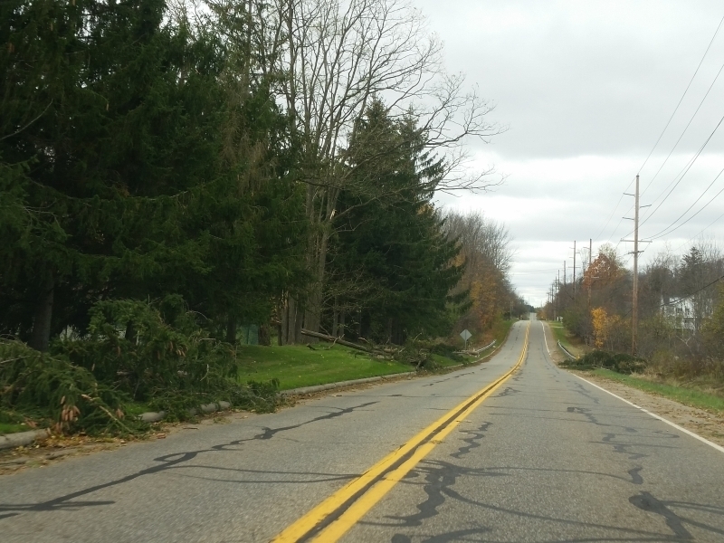
4 hours ago, NEOH said:
Lots of damage at the corner of Snyder Rd and East Washington in Bainbridge. Trees and power lines down all over the place. There seemed to be distinct path on east down East Washington. Wonder if there was a brief spin-up in that area.
You aren't kidding! East on Washington is closed at Snyder. Here's a few pics. One looking east and one west.
-
I was out of town for the storms last night, but looks like they stripped most of the remaining leaves off of the trees. Glad to see we're back into a wet pattern. Now just need some cold air.
-
What a beautiful weekend! Looks like it may be our last taste of 70s for a while. Flakes next Sunday?
-
Winter watches and warnings being consolidated. Looks like we still keep les warning.
http://www.weather.gov/cle/news_winter_hazard_simplification2017
-
15 hours ago, NEOH said:
Picked up .35" of rain last night... most rain I've had in quite some time. At least it will keep the dust down. I can't remember the last time is was this dry. Back to mild temps, blue skies and sun.
Nice to see the rain again. Looks to continue off and on the next week. Hoping we start to get back into a wetter pattern with snow season quickly approaching.
-
1
-
-
Good deal, hopefully we have a good winter. The lake should be primed pretty good with the recent heat wave, and more in early October.
-
Going to be a nice week if weather. Dry and 80s. Would like to start getting into a wet pattern soon.
OHweather. ...you going to be here for this winter? You mentioned maybe moving last year.
-
I haven't really noticed the smoke, but there have been some cool mornings the past week or so. Hard to believe snow season is fast approaching already.
-
Happy 4th all! Really has been a pleasant summer so far. No long stretches of humid, hot and dry weather yet. We'll see what the rest of the month brings.
-
Hopefully that's the last until October!
-
Had an additional 1.5" of very compacted snow since this morning. Going with a storm total of 6". Bring on the 60's now!
-
3 minutes ago, OHweather said:
After a little more snow and a few measurements, came with a total of 3.4". Pushes me over 60" on the season (60.4") which is about 75% of normal (figure maybe an 80" average out here)...all things considered, compared to how the west side is doing, I suppose I can't complain much.
After today's snow, I believe I'm over 80" on the season. All in all it felt much worse. I had to double check my excel formulas this morning, because it doesn't feel like that much snow fell. The lengthy and frequent snow less warm spells that this winter has had are what will be remembered.
-
Measuring off of the deck, had 4.5" as of an hour ago. Curious how central and west Cuyahoga did. They had some good returns in that area for a while , but may have not been all snow.
-
With all the wet weather lately, have really noticed the grass greening up and starting to grow this past week.
-
Just glancing at the radar, may have some impressive snow rates in time for rush hour unless it warms enough for just rain.
-
46 minutes ago, Trent said:
Congrats. The radar looked great last night around that area.
I was also surprised at how even with sub freezing temps the past few days how the snow still melted from the ground up. My driveway was mostly scoured clear by the wind, but when I removed some of the drifts it was all slush underneath.
I definitely noticed yesterday while plowing that the bottom layer was slushy. This morning it was definitely true powder.
-
Looks like 4.5" fell since 10pm last night. Storm total is at 15". I'm guessing there may be slightly higher overall totals just to my west near chagrin. The band hugged that area for a while.
Northern Ohio Obs/Discussion Part 2
in Lakes/Ohio Valley
Posted
We're bound to cash in sometime in the next few weeks. Will be nice to get into a wintry pattern.