

dta1984
-
Posts
1,698 -
Joined
-
Last visited
Content Type
Profiles
Blogs
Forums
American Weather
Media Demo
Store
Gallery
Posts posted by dta1984
-
-
Absolutely fantastic early March weather! Looks like the majority of the rain might miss us too. 60's in the forecast for the next 10 days...though I'm sure it'll change.
-
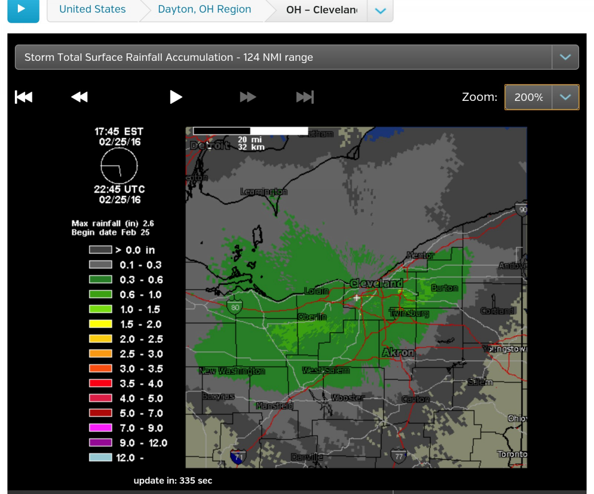
2.5" at CLE. Not bad for this winter. It snowed for almost 16 hours straight too. Too bad we can't seem to get heavy rates and long duration at the same time.
This was another storm where the pavement stayed wet throughout the event. I think there may have been only 3 times this winter I actually had to move snow from the driveway.
I came up with 1.75". Ya the one bright spot of late season snow is unless it's a big storm, the sun usually takes care of the driveway.
-
2.5" on my deck. Driveway was covered this morning, but once the snow slowed down, the march sun angle did its thing.
Sitting at 62" for the season. After this weekend, I'll be ready to shift into spring mode and forget this winter.
-
Speaking of a couple of inches of fluff snow lol..... looks like 1-2" out there. Snowing nicely though..
-
That what surprised me. Sun is poking through and temps are climbing. Looks like nothing more than a frontal passage.
Feels pretty nice outside.
I don't think the Euro has been performing well as of late. Quite the change.
-
Looks like some general agreement for 3-6", though placement is a little different between models.
-
No model consensus for a storm a few days away - sounds like March. Verbatim the Euro is a foot+ for all of NE Ohio up through Buffalo. I will gladly take this storm and move on from winter weather.
My thoughts exactly! One last storm and let's move on. If only there was some consensus on this track lol.
-
Yeah, more snow that I expected. It really ripped late afternoon so we made up a lot of ground quickly. I measured various amounts... all between 3-6". There was probably half that amount on the pavement.
Ya, as I was out last night I noticed there sure didn't look to be 5" on the ground. My driveway had bare spots, then spots of 4" which was probably mostly wind blown. The surface of the deck was definitely the coolest.
-
Radar estimate shows the east side near Solon, then ne from there did well. Though ...probably not the most accurate.....
-
I've got 5.25" on my deck. Definitely more than I was expecting.
-
Ripping pretty good in Solon. I'd guess 2" down. Home Webcam shows what appears to be the same.
-
We'll see if the radar starts to light up this afternoon. So far, the snow has been unimpressive. We are going to struggle to meet advisory criteria unless it starts pouring snow this afternoon.
Yep, hopefully it will improve. There are a few yellow moderate pockets starting to show up as it shifts east.
Didn't measure this morning, but probably 1/2" in the grass.
-
Map from cle is a general 3-4" across the area. Seems like a good call. A few models had 6" spots in the Snowbelt.
-
The mid week storm should set the stage for a nice lake enhancement event as the low pulls off to the NE. After this weekend's warm up, a lot of the ice on Erie melted. Should be interesting to see how this unfolds.
It is definitely getting more interesting. Seems the trend has been back to the east a little since yesterday. Several models put 3-6" near cle. Could be a nice storm if there's a little more enhancement to top it off.
-
Torching at 65 degrees. Feels great outside!
-
The great melt begins today. A few days of temps near 50 or better, and lows above freezing should have no problem wiping out the snow.
As of yesterday afternoon, the depth on my deck was just below 12".
-
Fairly strong band approaching. The end of this may put down a quick 1/2".
-
Picked up 4" overnight. Heavy snow for a change.
Same here. Should really compact the lake effect fluff underneath.
-
Looks like they haven't looked at any model runs since yesterday morning. They still have time to fix it this afternoon and get some lead time on the snow but they better get it right now and not wait till 4am to do it.
Their new map looks better.
Wwa out for east of cle for 3-6". Seems reasonable, but a few more ticKS nw and could be pushing the upper limit.
-
Exactly, hopefully we benefit this time.Think of all the times CLE has been screwed by last minute NW trends over the years. Could one of these last minute jogs NW actually be beneficial to us?
Obviously the more east you are, the better. But the potential is certainly there for a high impact event.
Realistically CLE will probably get 2" and those out in Geauga would get 4". Such a tricky forecast for the mets today.
The RAP has an 8-12 weenie band through cle. Then again. ..it's the rap lol.
Edit; so does the hrrx.
-
The trends yesterday looked favorable, but the models have backed off today. It'll probably end up barely whiffing most of NE Ohio, with the PA border getting something.
This was basically the first legitimate synoptic storm threat for us in a year.
The short range models aren't horrible, but the 6" line looks to stay slightly se of here. Maybe this will trend in our favor.
Had a light coating of snow this morning, but didn't get a chance to measure. Guessing .5".
-
Picked up am additional .5" last evening / overnight.
Looks like we may salvage a few inches from the early week storm. After that, things warm up some. Hopefully enough to break up any ice that formed on the lake.
-
Looks like 3" fell overnight. A lot of wind, so hard to measure.
Persistent light to moderate snow showers the past few hours. Tiny flakes, not sure it'll amount to much.
-
My general thinking is a short duration of heavy snows late tomorrow afternoon and evening followed by lighter multi-bands with lower ratios due to the cold Saturday into Saturday night. My early guess is 3-6" in the higher terrain from Medina east through the Snowbelt with 6-10" where the Huron connection is (most likely eastern Ashtabula or NW PA). Amounts are marginal but the burst of heavy snow late tomorrow and falling temps/gusty winds tomorrow night into Saturday should and "hopefully" will prompt advisories from Lorain and Medina Counties east.
This kind of snuck up. 3-6" sounds good.
Euro showing us love for next week.
I'm going to add .75" to my totals for snow that fell after I left this morning.
Lake effect = 15.75"
Since Monday = 18.75"
Northern Ohio Obs/Discussion Part 2
in Lakes/Ohio Valley
Posted
Temps really climbing since the rain stopped. Car said 65 on lunch. Can really notice the grass green-ing up, and starting to grow. If it can dry out, won't be long before we're cutting grass.