
AppsRunner
-
Posts
2,420 -
Joined
-
Last visited
Content Type
Profiles
Blogs
Forums
American Weather
Media Demo
Store
Gallery
Posts posted by AppsRunner
-
-
18 hours ago, cyclone77 said:
We've had a lot of things shift in our favor in the final 24-48hrs this season, which can definitely make a forecaster look like an ***hole. I admit I can be a bit pessimistic at times, probably in some way trying not to jinx the storm lol, but to say I low-ball everything is simply not accurate.
Other than the January 9-12 system, I can't recall any other storms trending northwest in the final 24-48 hours. It's been odd.
-
Final total here about 3-3.5". Still have yet to eclipse 4" from an event.
-
 1
1
-
-
-SN started about 30 minutes ago, we're probably down to moderate SN with about a 1/2 to 3/4 SM visibility. Really good dendrites to start the event off.
-
1
-
-
At least some slight improvements on the west end in the latest RAP/HRRR runs. Cyclone needs to turn up his magnet to a higher setting this time around.
-
 2
2
-
-
34 minutes ago, cyclone77 said:
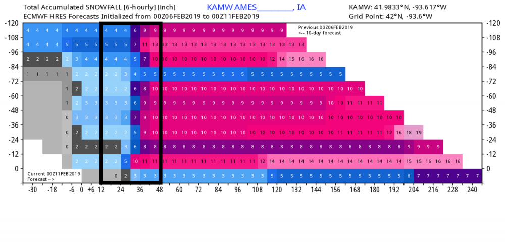
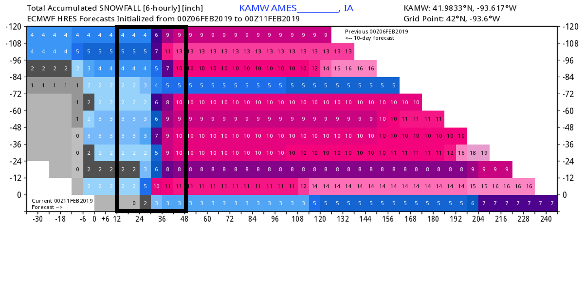
Now about 6-8hrs from the start of the event and it's still a little muddled as to what to expect. The GFS has consistently been showing an all snow event for the QCA, and other guidance seems to be trending in that direction. HRRR/RAP/NAM3 still bring the snow/mix line up to this area by mid evening. RGEM still gets us into all rain for a period, but it has trended south as Chicago Storm pointed out. Compared to yesterday the period of mixing is substantially less. It would still appear the northern/western DVN cwa has the best shot at the most snow, but if trends continue the QC may end up doing quite well out of this yet again. Apparently it's just one of those seasons when everything seems to trend in our favor in the final 24-48hrs.
4We know what you're gonna end up with
")
Trying to break my event high of 4" with this storm.
-
1
-
3
-
-
"King Euro"
-
Nothing like your 100 mile east shift with the QPF on the euro 24 hours before precip arrives.
-
2
-
-
Just now, cyclone77 said:
The difference in the placement of the snow/mix line is just lol worthy for being less than 24hrs out. GFS is an all snow event here and buries us with 6"+, while the RGEM says we'll be hearing the pitter-patter of rain on the roof all night.
It seems like this is every storm here in Iowa this winter. I have no doubts you'll pull out 6" or so somehow
-
2
-
-
Pretty good agreement between the UKMET/GEM/ECM across Iowa into E MN/W WI with a swath of 0.5-1.25" of QPF stretching from southwest Iowa up to La Crosse or so. Seems if any storm is going to be the big one of the season for DSM/LSE it'd be this one.
-
26 minutes ago, cyclone77 said:
Today's snow ended up being a non-event. Picked up 0.2". What u might call a classic dog turd duster lol.
Must've stolen some of your luck. Somewhere around 3.5" or so here. DMX had 4.5" at their office. Really nice dendrites this morning during the good rates this morning.
-
2
-
-
The NAM has repeatedly been underdoing precip in its long range, I have little faith in its solution outside 48 hours.
Meanwhile the GFS/GEM are largely similar to previous runs
-
1
-
-
5 minutes ago, ILSNOW said:
Has the GFS-FV3 ever been correct?
That's two events using Kuchera method on a model that's been wetter than most other guidance.
-
The FV-3 is spitting out ridiculous QPF amounts for the next two systems. It has over a half inch of liquid for the weekend threat and 1.5"+ for the Tuesday storm. Seems a bit far fetched.
-
Figured it's worth starting a thread as we're now within a week. Good support for a storm somewhere in the subforum early next week. Euro/GFS/FV3 all point to a potentially significant winter storm, and the euro ensembles have some strong solutions going from the OK panhandle to as far west as MSP and as far east as BUF.
-
1
-
-
We've picked up a glaze of ice and a trace of sleet so far, but it's still icy. Round two is looking like it could be a heavy burst of snow tomorrow morning/afternoon across Iowa, though the NAM isn't fully onboard yet. The rest of the models look good to at least get the grass white again.
-
13 minutes ago, CNY-LES FREAK said:
Good call Dave on Oswego getting virtually nothing as they're nearing close to a foot as we speak and it's still coming down very hard, lol!
Sent from my SM-G930V using Tapatalk
What? The campus got a couple inches. Where did you see a foot?
-
Band still drifting/pivoting south, and still quite intense. Lake Ontario never disappoints in terms of actual snowfall rates.
-
Watertown picked up another 7.4” in the last two hours, CoCoRaHS says just under 3 feet now as a total. Finally shifting south
-
KART picked up 0.13" liquid equivalent last hour. The two hours when they got about 3.5"/hr. were 0.07 and 0.09". I'm still not seeing any significant movement in satellite upstream at the moment and there seems to be an excellent convergence zone right over Watertown. @WxWatcher007 I would fully expect this continue for at least another hour or so before things gradually shift.
-
CoCoRaHS and another Spotter in Watertown reporting 3.6"/hr. and 7.1" the last two hours.
-
4
-
-
Just now, CNY-WXFREAK said:
i'm still trying to figure out why Oswego County is still under WSW??
Because Pulaski/Sandy Creek/Redfield are going to get warning criteria snow tonight, and they are in Oswego county.
-
Just now, wolfie09 said:
Latest HRRR runs moved north a little like expected, drops the band south over the area around 8pm..
Could be a decent one for somebody..
The other day pulaski picked up nearly double digits in 5-6hrs under similar circumstances.
I've been trying to tell you Redfield/Tug Hill folks over and over again that your snow is still on track. Should have a good portion of tonight/tomorrow to pick up accumulations.
-
1
-
-
I think what's most impressive is how well the KART ASOS is picking up liquid. 0.09" last hour and 0.07" this hour. Even on a conservative 20:1 ratio that's about 2"/hr. Chances are it's closer to 3-4" now.
-
1
-
-
My two friends chasing say they can't even see a thing out the car window. Sitting I-81 at Route 3 in W Watertown. @WxWatcher007 how much fun are you having?
Upstate/Eastern New York
in Upstate New York/Pennsylvania
Posted
A few strikes on the oswego campus the last couple hours. I’m sure they’re having fun.