
AppsRunner
-
Posts
2,420 -
Joined
-
Last visited
Content Type
Profiles
Blogs
Forums
American Weather
Media Demo
Store
Gallery
Posts posted by AppsRunner
-
-
Already a 6" and 4" out of downtown and Williamsville, respectively. Temporary disorganization for now before things start to get intense later this evening.
-
 2
2
-
-
39 minutes ago, BuffaloWeather said:
Wow, this is fantastic, Thank You! Can you post your map for Erie? Also, what are your thoughts on the lake ice increasing on Erie during tomorrow and Thursday? Any possible thunder in the bands?
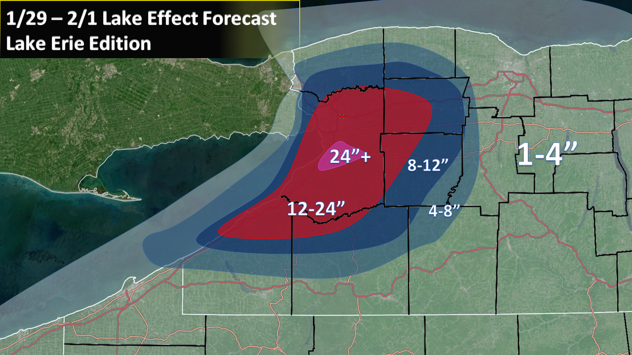
Not patient enough to make it look as good as the Ontario one for now, but here's my best effort. Worth noting I don't forecast for Erie often so if my map looks weird that's why. Try to imagine that 24"+ contour is basically Hamburg and East Aurora.

-
 1
1
-
-
2 minutes ago, rochesterdave said:
I wonder what makes you think Syracuse gets into the action? Is that more frontal and upslope? I just don’t see any NW component to this round. Despite having a huge H directly to our west (normally nw) but I guess the upper low to our N just dominates this flow.
More of a case of just broadbrushing the southern edge. Winds will eventually swing a bit more WNW/NW'erly for a brief period Thursday night/Friday morning before things fully shut off. You can kind of see the same thought in the BUF map. I probably should've adjusted Cuse out of the 4-8" but I still think they have potential at the end of the event.
-
Just now, BuffaloWeather said:
Wow, this is fantastic, Thank You! Can you post your map for Erie? Also, what are your thoughts on the lake ice increasing on Erie during tomorrow and Thursday? Any possible thunder in the bands?
I don't have a fancy template lying around for that area right now, but I can throw something together here in a minute.
There will certainly be some ice increase over the lake with such cold temperatures... which is why I'm a little nervous my forecast is too aggressive. There have been a few studies that show there's still significant latent/sensible heat fluxes with thin ice cover, so I think that there's going to be some lake-effect regardless of if ice cover increases. Satellite looks basically completely ice free near Sandusky/Toledo where the National Ice Center is analyzing ice cover. If I remember correctly, the NAM/3k NAM use that data for their lake ice information, which means your hi-res guidance isn't going to do particularly well in a situation like this. In fact, you can already see hints of it on the NAM overnight tonight, where the west half of Erie has the same temperature as the actual ground:

I remember an event off Ontario in 2014 where the models essentially thought the whole lake was frozen (hint: it wasn't fully covered) and spit out almost no QPF. That case didn't have nearly as good of a thermal profile as we have with this event. There are additional impacts that limited ice cover could cause, like if new fricitional convergence zones can set up that are harder to forecast.
There's always a chance for thundersnow in these events, with such steep lapse rates and a fat CAPE profile it seems likely we get at least a few strikes over the next couple days.
-
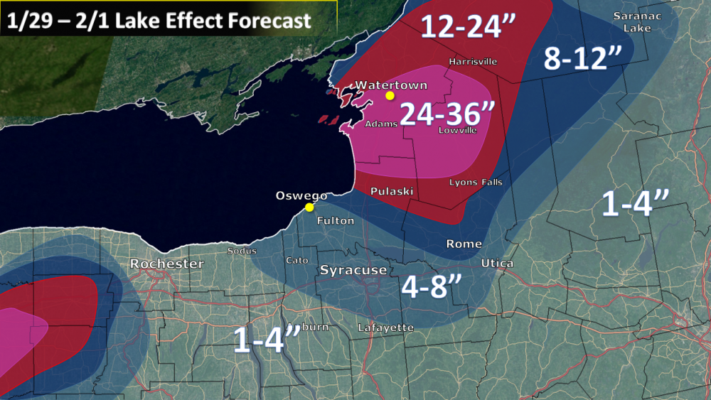
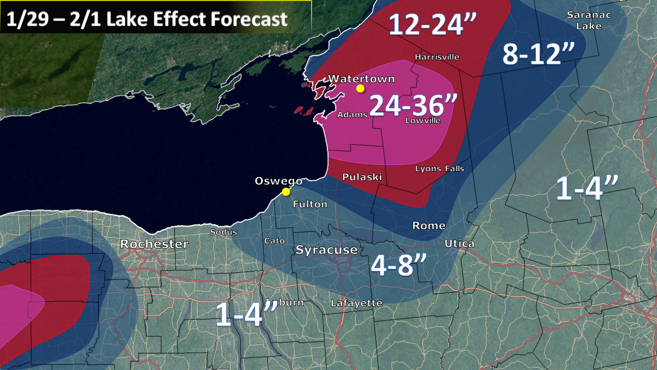
Meant to type something up last night… but I guess this will have to do. I’ve been away from the LES action for a little bit so take it with a grain of salt.
I’m fully on board for a pretty significant event for BUF and for a large portion of Watertown/Tug Hill through Friday. I still think that ice chart that was posted the other day is fairly inaccurate. Based on the few pieces of the lake we can see right now, it seems to be more open than that map or the one from the National Ice Center seems to suggest.
Off Erie…
Lake effect has already developed a little quicker than expected right now, and an intense singular band appears to be organizing. This isn’t terribly unsurprising, given the 850mb front just passed over Lake Erie and winds are beginning to become better aligned. As temperatures continue to crash and boundary layer winds slacken a little bit through the afternoon, I see no reason that additional organization should continue throughout the day. Boundary layer winds are fairly unidirectional at about around 240°, which should put BUF in or just south the heart of LES through the day. While Lake-induced equilibrium heights only hover around 6-10kft the boundary layer does deepen significantly through the day. We also have fairly good snow growth potential today, as the DGZ still is within the cloud layer through at least the early overnight hours and also evidenced by some recent observations of dendrites falling in the heavier portions of the band.
Overnight, temperatures continue to fall and the boundary layer deepens to at least 700mb, as EL’s grow to 10-13kft, with LI CAPE profiles >1000J/kg. Boundary layer winds are very well aligned, though gradually shift from 240-250°. With the dendritic growth zone gradually be pushed down to the surface, it’s hard to expect extremely high ratio snow to continue, though there is just enough lift off the surface that there should be at least some snow growth to work with. Additionally, soundings suggest the potential for rather strong surface winds >20kts, which, combined with finer flakes and already significant accumulations, should lead to blizzard or near blizzard conditions. If LES develops as expected, I would not be surprised to see blizzard warnings for the BUF metro, especially if this continues into the rush hour traffic on Wednesday morning.
Same story continues Wednesday as lake-effect gradually slides south of the metro and towards southern Erie/northern Chautauqua/northern Wyoming/Genesee counties. Most of Wednesday looks to be heavy snow… though with variation in the overall band orientation should limit totals. There should still be a well organized, heavy lake-effect band as boundary layer depths reach about 650mb with 1500J/kg LI CAPE and ELs approaching 15kft. If some of the areas hit today/tonight can get into the action again, I could see totals approaching 30-36” (that’s not my actual forecast). Wednesday night through Thursday EL’s gradually decrease and boundary layer depth also decreases a bit as the best cold air move out of the area, with the same general areas seeing additional accumulating snow.
I do still have a few concerns that could limit this from being one of the “big ones”. How does limited snow growth potential limit snowfall rates? How do relatively strong boundary layer winds affect lake effect organization (and again), snowfall rates? While both of these factors are likely to increase the blizzard potential from the event, it may limit overall totals, especially in the latter half of the event. Another question I have is if this band can manage to impact Rochester as well - I have them in lower totals right now but I could see 6" amounts if things line up perfectly.
Off Ontario…
As the low-level cold front has yet to make the trek across Lake Ontario, we have obviously yet to see any significant development downwind of Ontario. Guidance suggests that this should change by the overnight hours as the arctic front sweeps eastward this afternoon/overnight. The models aren’t explicitly showing this, but it looks like there’s some fairly good potential along the front for some heavy squalls, especially east of I-81 as steep lapse rates and additional upslope may provide a quick burst, leading to some minor accumulations.
Lake-effect should gradually develop overnight tonight, though there is quite a bit of shear near the top of the boundary layer initially tonight. I think there’s also potential for the Erie band to feed into Lake Ontario overnight, though getting the flow perfectly aligned for that setup is a little more complicated to predict. Either way, lake-effect should first develop near/north of Watertown with 240° winds through the morning hours on Wednesday. Winds very slowly shift a little bit further south through the afternoon Wednesday, with very well-aligned flow and deep moisture suggesting >2-3”/hr. rates seem likely at times, especially if the Erie-Ontario connection can happen.
A mid-level shortwave moves through the area Wednesday evening, which will briefly disrupt the flow to become more westerly, similarly to Lake Erie (albeit a few hours earlier). This should shove the band down towards the Tug Hill for at least a brief period Wednesday evening/overnight. Forecast gets a little bit more complicated as a little bit of shear through the boundary layer makes it a bit tougher to guess the exact position of the band through Wednesday night. BUFKIT suggests this setups up somewhere between Redfield and perhaps just south of Watertown. Previous experience leads me to guess southern Jefferson/northern Lewis counties with a 260° wind, where a 270 wind seems to be more of the Oswego/Jefferson county line.
Winds will again gradually shift towards the WNW from Thursday morning into Friday, though inversion heights decrease and moisture becomes a little bit harder to get. However, EL’s of 6-10kft should be plenty to generate heavy snow.
Snow growth potential looks a little bit better of Ontario, as I assume the lake surface is at least slightly warmer than Erie, and I’d almost assume its closer to 37-39F, and there seems to be at least a shallow DGZ near the surface through most of the event. Some of the soundings the NAM and 3km NAM spit out are rather incredible, but we’ll have to see how they play out. The same concerns I have off Lake Erie are concerns for Ontario as well, but I think Ontario is primed for likely it’s biggest event of the season.
Map below, but for Erie:
KBUF: 20”
Dunkirk: 18”
Hamburg: 29”
Batavia: 16”
Feel free to ask any other thoughts. Since I’m in the icebox that is Iowa, I have a decent amount of free time over the next couple days.
Edit: Uploaded the old map from last night, new one attached.
-
5
-
1
-
-
25 minutes ago, snoblo said:
Bradley in Peoria and Illinois State in Normal have done the same.
Iowa State joins the list as well. I'm sure there's others in between that I haven't heard about, but having the two biggest schools in Iowa shut down for roughly 48 hours is pretty impressive.
-
9 minutes ago, Hoosier said:
Too bad it appears the coldest 850 mb temps will pass over DVN in between RAOB times. They should do off hour launches for something like this.
The intern that would have to perform the flight disagrees
")
U of Iowa has already cancelled classes Tuesday PM - Thursday. Wonder who will follow suit
-
The first half of the month looks to be reasonably active as the trough axis moves a further west after this cold outbreak. Probably a little more potential for a bigger snowstorm than the last few weeks, and a lot more temperature variability too.
-
1
-
1
-
-
After getting to 37 a couple hours ago, it’s now 18 with gusts to 45mph
-
3
-
-
At least locally, the NAM/3k are much more "mild" compared to the GFS. Lows on Weds Night only drop to around -15 to -20, compared to the GFS and -27. Further east towards WI/IL it seems to be much more certain of a lock for all-time record cold.
-
Final total 2.0-2.5”
Loose estimate because there’s already a good amount of blowing and drifting.
-
We’ve held on to snow for a little longer than I thought. Bright banding and Reduced CC a county west suggest it won’t be too much time till sleet/freezing drizzle/drizzle begin. Hopefully we can get above freezing at some point.
10F right now.
-
1
-
-
We only managed to get to -5 last night which is encouraging. Wonder how the cold will be handled by people. Obviously the schools will close but what about businesses/universities?
-
7 minutes ago, cyclone77 said:
Quite the challenge along the southern edge based on the latest guidance. The GFS and RGEM have 0.4-0.5" of precip for the QCA, while the HRRR/RAP/3km NAM have considerably less precip. You would think leaning on those higher-res models would be the way to go at this point, but the shift south with the heavier precip on the other models is noteworthy. From a forecast standpoint the best bet is to just go with a wide range of totals, which is a bit frustrating lol.
Can I borrow whatever black magic stuff you got going on there? To be honest I would expect continuing trends up through the event start time, similar to the last couple events. You seem like you could probably pull a 4" event out of a 1040mb high this winter so I like your odds here.
-
1
-
 5
5
-
-
Managed about 1” today. Only clipper to produce anything here
-
3 minutes ago, Hoosier said:
imo, too early to bail if you're within like 50-75 miles of the current progged location of the heavy snow swath. Adjustments of that magnitude at this time lead, while perhaps not extremely common, are not some exotic rarity.
Especially after the GFS shifted 150 miles within 48 hours last storm.
Personally would love to get above freezing. Wouldn’t be upset to see a little rain to clear off my car too.
-
GEM a tick North from its 12z run. Hoping to avoid rain here before the arctic hammer
-
There is going to be very strong westerly WAA ahead of this system which will obviously impact the baroclinic zone. There's a 20C temperature gradient at 850/925mb over about a 75 mile stretch! Wouldn't get too caught up in many details yet. A few have pointed out that clippers tend to trend southward... that may be be true most of the time but it's far from a guarantee here. I'd love to be in a corridor from LSE to Cyclone77 to CHI right now.
-
3
-
-
A lot of ensemble support for at least one of these clippers to be something big, but wouldn't want to get caught up in any more details than that for at least a couple days.
-
Looks like about 4.5" here. Overperforming underperformer I guess, which makes it the largest event of the season.
-
1
-
-
MLI with 6.8" so far, impressive. DMX office at 6.6", 4-6" seems to be common in between. Not sure how I fared quite yet, will go out and measure once this final band moves through.
-
Just now, StormChaser4Life said:
Does anyone know a good place to see current pressure falls? I use to use unisys weather but seems they discontinued it now
SPC Mesoanalysis has 2hr pressure change on the "Surface" tab.
-
Fgen in IA means business. AMW down to 1/4SM. Don't have a good view out the window to see accumulations though, but the Omaha area was picking up about 0.5-0.75"/hr.
-
3
-
-
-SN here in Ames. There isn't the worst flake size at the moment. We'll see how it plays out this evening.
Another thing to watch for us central IA folks is the passage of the 500mb low late tonight which produces some decent precip overnight - at least on the globals and now the NAM/RGEM to some extent. I'm not sure if that's legitimate - especially given how awful the trends have been the last day or so - but the signal is there to produce a couple inches even as we get towards the morning hours. Some decent banding right now which wasn't particularly well handled.
Upstate/Eastern New York
in Upstate New York/Pennsylvania
Posted
You used to live in Fulton, right? Altmar really will be pushing the southern fringe most of the event. Best of luck to you!
I believe you're correct... those are very low level tilts that have the hole (<500ft), if you go up to the 0.9 degree tilt (600-700ft) the band looks much more coherent. I don't have any solid guesses of what's causing that though. My only thought would be something airport related? But that's about all I got.