nchighcountrywx
-
Posts
2,666 -
Joined
-
Last visited
Content Type
Profiles
Blogs
Forums
American Weather
Media Demo
Store
Gallery
Everything posted by nchighcountrywx
-
2025-2026 Fall/Winter Mountain Thread
nchighcountrywx replied to Buckethead's topic in Southeastern States
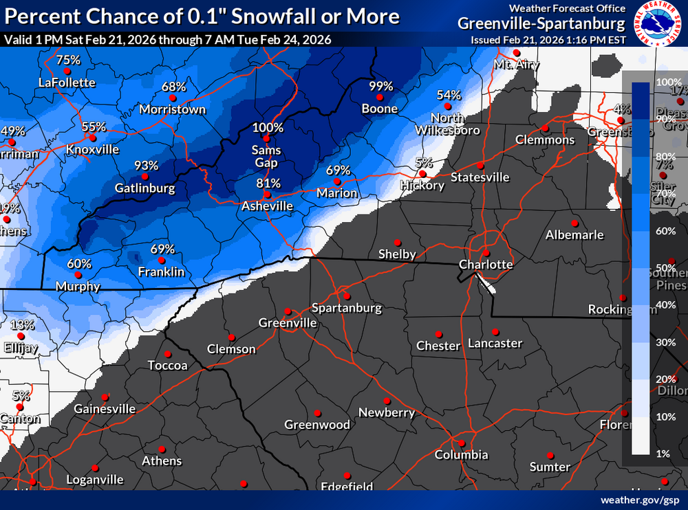
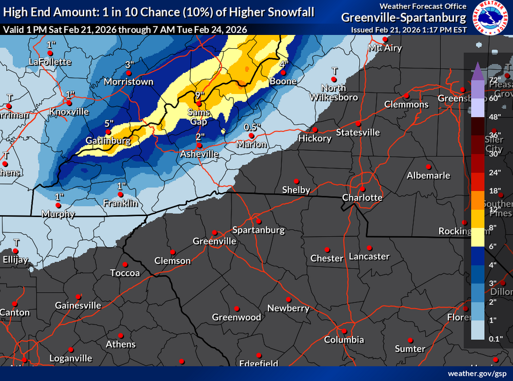
Latest guidance from GSP KEY MESSAGE 2: A BRIEF RETURN OF WINTER WEATHER WITH VERY GUSTY NW WINDS, ACCUMULATING SNOW FOR PORTIONS OF THE MOUNTAINS AND BELOW NORMAL TEMPERATURES SUNDAY THROUGH TUESDAY. NORTHWEST FLOW REALLY RAMPS UP ACROSS THE FORECAST AREA ON SUNDAY, AS A COASTAL LOW RAPIDLY DEEPENS IN THE MID-ATLANTIC COASTAL WATERS. A TIGHT PRESSURE GRADIENT AND STRONG LOW-LEVEL CAA WILL SUPPORT VERY GUSTY WINDS ACROSS THE AREA BY EARLY AFTN AND CONTINUING INTO SUNDAY NIGHT. PEAK GUSTS OF 30-40 MPH CANNOT BE RULED OUT ACROSS MOST OF THE FOOTHILLS AND PIEDMONT SUNDAY AFTN, BUT PEAK GUSTS INTO ADVISORY-CRITERIA RANGE OF 45-60 MPH WILL BE POSSIBLE ABOVE 3500 FT HEADING INTO SUNDAY NIGHT. WITH THE STRONGEST WINDS BEING IN LATE IN THE 2ND PERIOD AND INTO 3RD PERIOD, WILL HOLD OFF ON ISSUING A WIND ADVISORY. THERE MAY BE A BRIEF LULL IN SNOW SHOWER ACTIVITY IN THE MOUNTAINS LATE SUNDAY MORNING THRU ABOUT MIDDAY, BUT MOISTURE SHOULD INCREASE AGAIN IN THE AFTN AND RAMP UP SNOW SHOWERS ALONG THE TN BORDER. SNOW ACCUMS WILL BE HIGHLY ELEVATION-DEPENDENT FOR THE FIRST FEW HOURS OF THE EVENT DUE TO WARMER VALLEY TEMPS. THERE MAY ALSO BE A BAND OF RAIN DEVELOPING WITHIN A DEFORMATION ZONE ASSOCIATED WITH THE COASTAL LOW THAT COULD SET UP JUST EAST OF I-77. THIS IS NOT EXPECTED TO BE HEAVY AND SHOULD BE ALL RAIN. OTHERWISE, SKIES CLEAR OUT AND TEMPS RETURN TO BELOW-NORMAL FOR HIGHS, MAINLY IN THE 30 TO LOWER 40S IN THE MOUNTAINS AND UPPER 40S TO LOWER 50S IN THE PIEDMONT. THE NORTHWEST FLOW SNOW MACHINE WILL BE CRANKING UP SUNDAY EVENING, AS A STRONG MID-LEVEL SPEED MAX DIGS FROM THE CORN BELT SUNDAY EVENING TO THE SOUTH CAROLINA COAST BY MONDAY MORNING. IN RESPONSE, THE DEPTH OF POST-FRONTAL MOISTURE COVERING THE TN VALLEY AND MUCH OF THE SOUTHERN APPALACHIANS WILL INCREASE TO NEAR 700 MB...WITH TEMPS AT THE TOP OF THE MOIST LAYER COOLING TO -16 TO -20C. WHILE THE DEPTH OF THE MOIST LAYER IS FORECAST TO BECOME GRADUALLY MORE SHALLOW LATE SUNDAY NIGHT THROUGH MONDAY, TEMPS AT THE TOP OF THE MOIST LAYER REMAIN NO WARMER THAN -16 UNTIL TUE EVENING. THIS MEANS A PROTRACTED PERIOD...30 HOURS OR MORE OF A HIGH PROBABILITY OF DENDRITIC ICE CRYSTAL GROWTH AND EFFICIENT SNOW:LIQUID RATIOS...ALL WITHIN PERSISTENT STRONG NW UPSLOPE FLOW. SOLID WINTER WX ADVISORY CRITERIA SNOWFALL IS LIKELY FROM THE HIGHER ELEVATIONS OF THE SMOKIES NORTHEAST ACROSS THE MOUNTAINS AND VALLEYS OF THE OTHER NC COUNTIES BORDERING TN. CURRENT FORECAST STORM TOTALS ARE GENERALLY IN THE 1-4" RANGE IN THE VALLEYS NORTH OF I-40, WITH ABOUT TWICE THAT RANGE EXPECTED ABOVE 3500 FEET. ESPECIALLY FAVORED UPSLOPE/HIGH ELEVATION AREAS ALONG THE STATE LINE WILL LIKELY SEE AROUND A FOOT OR MORE. THIS IS ENOUGH TO WARRANT ISSUANCE OF A WINTER STORM WARNING FOR AVERY COUNTY AS WELL AS THE HIGH ELEVATIONS OF MITCHELL COUNTY, WHILE WINTER WEATHER ADVISORIES WILL BE ISSUED FOR YANCEY, MADISON, HAYWOOD, AND THE HIGH ELEVATIONS OF SWAIN. WITH VERY WINDY (LIKELY WIND ADVISORY-LEVEL CONDITIONS OVER THE MOUNTAINS) AND COLD ADVECTION CONTINUING INTO SUNDAY NIGHT, WIDESPREAD WIND CHILL VALUES IN THE SINGLE DIGITS ARE EXPECTED ACROSS THE MOUNTAINS, WITH SUB-ZERO READINGS LIKELY ABOVE 4000 FEET OR SO. CURRENT INDICATIONS THAT THIS WILL BE "VERY CLOSE, BUT NOT QUITE" IN TERMS OF REACHING COLD WEATHER ADVISORY CRITERIA, BUT CAN'T RULE OUT THAT ONE WILL EVENTUALLY BE NEEDED FOR THE HIGHER ELEVATIONS AND/OR THE NORTHERN NC MOUNTAINS. SNOW SHOWERS WILL FINALLY STEADILY TAPER OFF MONDAY NIGHT, WITH DRY AND COOLER-THAN- NORMAL CONDITIONS EXPECTED THROUGH TUESDAY. MOUNTAIN WIND CHILL VALUES WILL AGAIN BE LOW MON NIGHT, BUT WITH WINDS STEADILY DIMINISHING, THEY ARE EXPECTED TO BE A LITTLE HIGHER THAN ON SUNDAY NIGHT. -
2025-2026 Fall/Winter Mountain Thread
nchighcountrywx replied to Buckethead's topic in Southeastern States

-
2025-2026 Fall/Winter Mountain Thread
nchighcountrywx replied to Buckethead's topic in Southeastern States
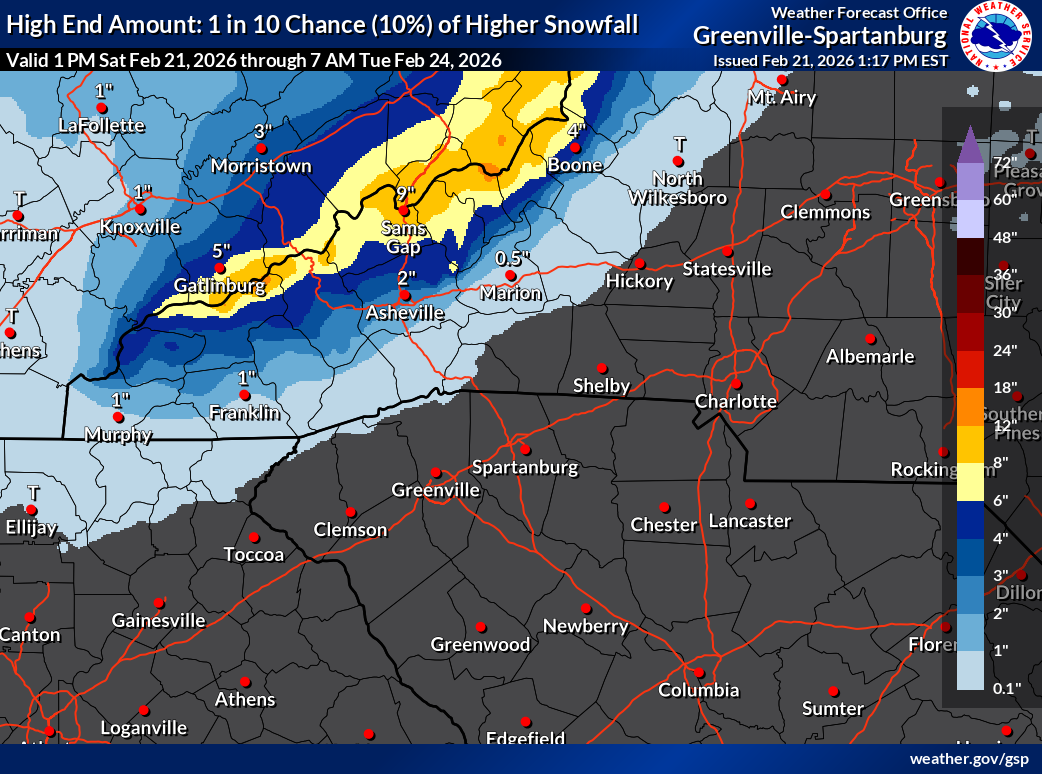
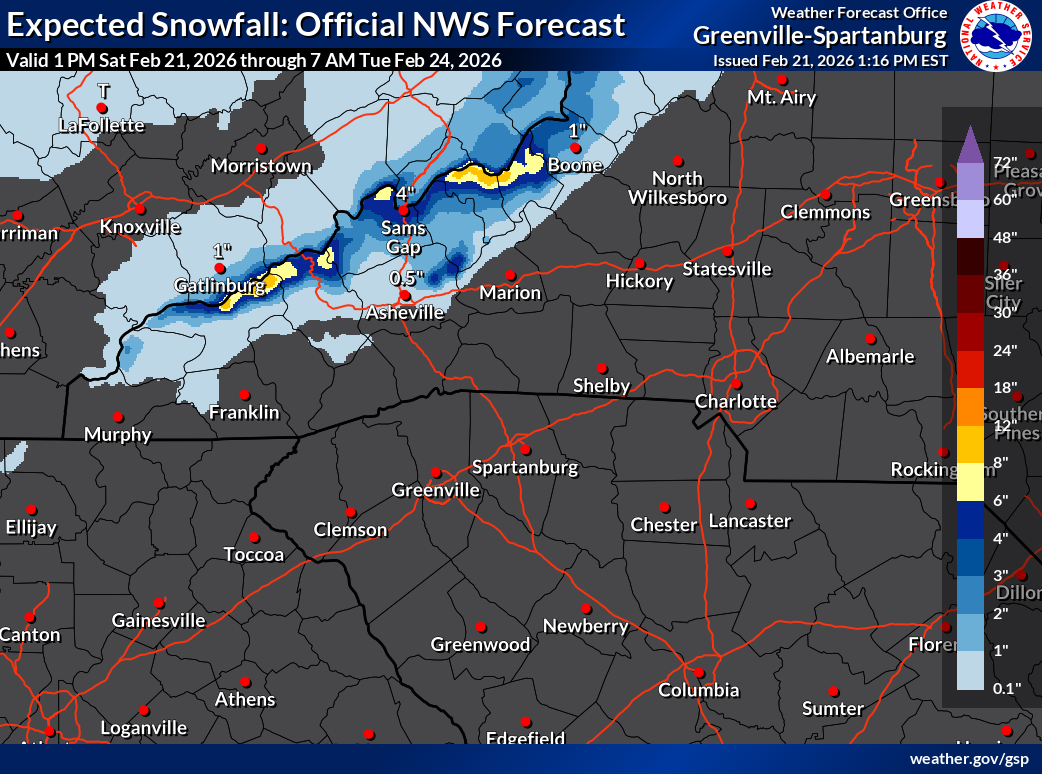
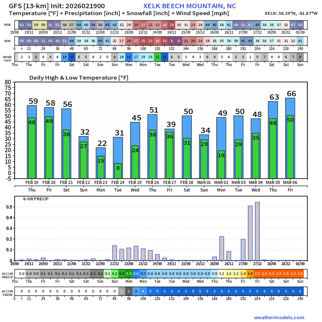
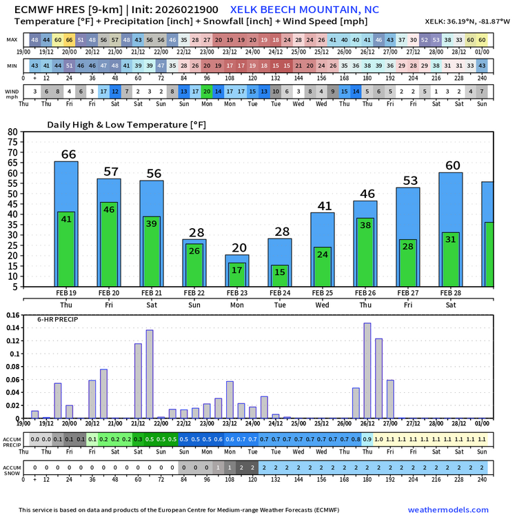
Winter Storm Warning hoisted. CZ033-220400-/O.NEW.KGSP.WS.W.0002.260222T0500Z-260224T0500Z/Avery-Including the cities of Banner Elk, Ingalls, and Newland150 PM EST Sat Feb 21 2026...WINTER STORM WARNING IN EFFECT FROM MIDNIGHT TONIGHT TO MIDNIGHTEST MONDAY NIGHT...* WHAT...Heavy snow expected. Total snow accumulations mostlybetween 2 and 6 inches, with amounts up to 10 inches possiblealong the Tennessee border and in the high elevations.* WHERE...Avery County.* WHEN...From midnight tonight to midnight EST Monday Night.* IMPACTS...The heavy snow will make many roads impassable and mayproduce a few power outages due to the weight of the snow on treelimbs and power lines. The hazardous conditions could impact theMonday morning and evening commutes.* ADDITIONAL DETAILS...Winds gusting as high as 50 mph could resultin areas of blowing snow and very low visibility Sunday night andMonday.PRECAUTIONARY/PREPAREDNESS ACTIONS...Monitor the latest forecasts for updates on this situation.Slow down and use caution while traveling.If you must travel, keep an extra flashlight, food, and water inyour vehicle in case of an emergency.&& -
2025-2026 Fall/Winter Mountain Thread
nchighcountrywx replied to Buckethead's topic in Southeastern States
-
2025-2026 Fall/Winter Mountain Thread
nchighcountrywx replied to Buckethead's topic in Southeastern States

-
2025-2026 Fall/Winter Mountain Thread
nchighcountrywx replied to Buckethead's topic in Southeastern States
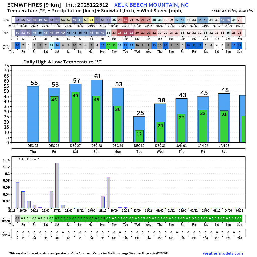
Official Guidance from NWS GSP: Key message 2: Accumulating snowfall is expected to begin Wednesday afternoon at high mountain elevations along the TN border. Snow level falls over the mountains as temps cool through the evening. Appreciable accumulations and the most significant travel impacts still look to be confined to elevations above 3500 feet. Flurries cannot be ruled out Wed night or early Thu morning in the Piedmont, though accumulation is not currently expected. As noted in previous forecast cycles, a compact southern-stream shortwave over the western Gulf Coast will phase with and be absorbed by a substantially deeper shortwave associated with an Arctic cold front tonight into early Wednesday. Low- to mid-level flow will back and amplify over the CWA during this time, ahead of the trough axis. Moisture return is limited at or below 850 mb, though by Wed morning deep saturation is seen above 800-700 mb; left-exit region of southern stream jet streak somewhat overlaps with right-entrance region of the northern one to concurrently bring some dynamic lift across GA and the Carolinas, which results in light QPF response near our southeastern CWA border in some models. This would be of little consequence given temps well above freezing in those areas. Saturation occurs closer to the surface during the afternoon just ahead of the surface front such that mentionable PoPs develop over the mountains; RH will be high at ice nucleation temperatures well aloft, so snow is possible wherever temps are cold enough in the PBL. Only the highest peaks appear likely to be cold enough for snow at onset, though rates greater than an inch per hour appear possible there. CAA from around 21z onward should begin to bring the snow level lower, particularly considering the wet-bulb temp profile, though temps still don`t cool fast enough to allow accumulation to begin in the valleys until after 8 PM. Lift will be enhanced for a time as the base of the shortwave shifts overhead, though drying quickly occurs aloft behind that. However, with temps continuing to fall and still decent low-level moisture, the PBL cools to support ice nucleation near the surface, with the needed lift then mainly resulting from NW upslope flow. Snow rates decline where NWF is not a factor. With strong (near-advisory) winds/gusts continuing, the upslope factor is respectable, and near 1"/hr rates look to continue on the peaks until the low levels too dry out after midnight Thu morning; additional accums after that time appear on the order of an inch or less, even in the higher elevations. Altogether it still appears this will be a highly elevation dependent event. Event totals of 4 to 8 inches now are expected in the highest elevations of the Smokies, with 3 to 6 inches on some of the higher peaks in the northern mountains and near Mt Mitchell. The larger cities in the mountain zones may not even see an inch per the current forecast, and averages for the lower-elevation portions of the zones are well below the 2 inch threshold for Winter Wx Advisory. Hence no Advisory is being hoisted at the current time, per local policy of considering the above- and below-3500 ft averages. Avery is considered as one zone as usual and does not meet the 2 inch criterion either. All this said, even the light accums may lead to some travel issues given overnight temps falling mostly into the teens, so will continue HWO mention. For the Piedmont, 15-30% PoPs are warranted Wed evening ahead of the base of the shortwave, though temps will be too warm for anything but rain at that time. Most model depictions show the cold air just barely chasing the precip, and particularly with saturation aloft and wet-bulb profiles near freezing down to the surface, it is reasonable to expect a few flurries will be seen. With the late overnight onset of subfreezing sfc temps, however, and the very light QPF depicted from those models producing it at all, any accumulation looks unlikely. Did see fit to add a flurry mention for the eastern I-85 and I-77 corridors where the overlap looks most likely to occur. Key message 3: Wind chills late Wed night and early Thu morning could prove dangerous in some higher elevations, requiring adequate protection from winter clothing. As noted above, winds will be near Advisory criteria in higher mountain elevations, where temps will fall into the lower teens (upper single digits above zero above 5000 ft). Resultant apparent temperatures fall into the -5 to -15 range which would support Cold Weather Advisory. Confidence is moderately high for such conditions above 3500 ft, but not yet confident if lower elevations may meet criteria. There remains time for re-evaluation on tonight`s forecast cycle, so will let the next shift take a look. Key message 4: Significantly colder temperatures continue Thursday through the weekend, albeit with a slight warmup on Saturday. Dangerously cold wind chills will be possible above 3500 ft Saturday night and Sunday morning. Any lingering light snow showers/flurries should end Thursday morning as moisture dissipates. The bigger story will be a cold air mass that moves in behind a departing cold front. Highs Thursday will be much colder than Wednesday, as much as 15 to 20 degrees below normal. Lows Thursday night will also be as much as 15 to 20 degrees below normal With winds diminishing overnight, locations with 5 below wind chill values should be limited to mainly locations above 4000 feet. Temperatures moderate Friday and Saturday high pressure moves east and a southwesterly flow develops. Lows Friday night and highs Saturday will range from near normal to up to 5 degrees below normal. Highs Saturday will be near normal with steady for slightly lower temps across the mountains. Another cold front crosses the area late Saturday or Saturday night bringing cold temperatures back into the region. Lows Saturday night through Monday nights will be nearly steady 10 to 15 degrees below normal. For now, winds appear to be low enough to keep wind chill values out of advisory territory for all but the highest peaks. Highs Sunday will be 15 to 20 degrees below normal then 5 to 10 degrees below normal Monday and Tuesday, with Monday the warmer of the two days. Key message 5: A clipper type low pressure/cold front may bring some light snow to the mountains Friday night possibly into Sunday. The cold air mass mentioned in the earlier key message will be proceeded by a clipper type cold front. The guidance varies greatly regarding this feature. The GFS favors a double barreled system with light snow showers for the mountains Friday night and early Saturday, then the second system on Sunday. The Canadian has a stronger system Friday night and Saturday with some precip spreading out of the mountains, then a series of weaker systems through Tuesday for mainly the NW flow precip areas. The ECMWF is similar to the GFS for Friday night and Saturday then a weaker system on Monday similar to the Canadian. And just to make things even more uncertain, the Canadian and GFS have a different flavor of a weaker font/clipper for Tuesday while the ECMWF is dry. The LREF mean shows light precip Fri nite/Sat then again Sat nite/Sun. The GEFS mean shows a light mountain event Fri nite/early Sat then a stronger event Sun/Sun nite. The Canadian ensemble mean shows a stronger event Fri nite/Sat with a weaker event Sat nite/Sun. Obviously, this makes for a confusing and low confidence forecast. As usual in these situations, have followed the model blend which shows light snow potential for Fri nite through Sat night with the possibility of some precip escaping the mountains across the I-40 corridor Saturday. Stay tuned as this will likely change. -
2025-2026 Fall/Winter Mountain Thread
nchighcountrywx replied to Buckethead's topic in Southeastern States
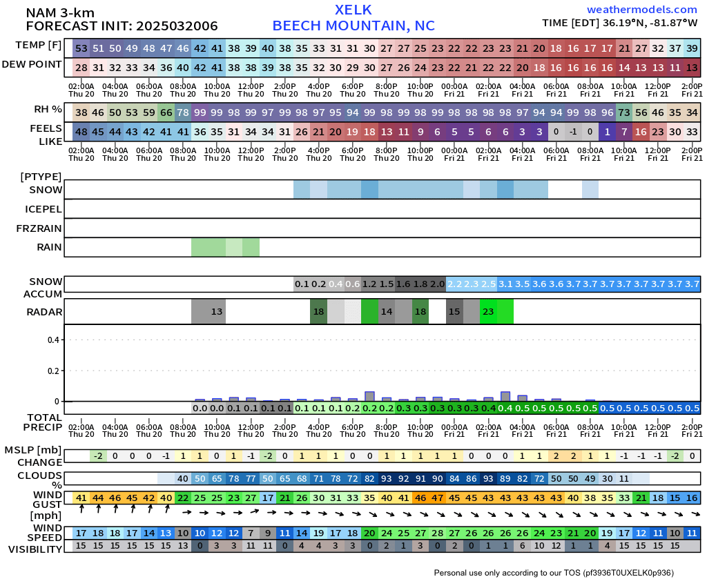
Guidance for Thursday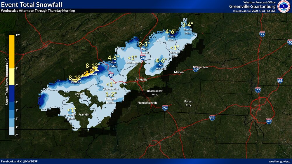
-
2025-2026 Fall/Winter Mountain Thread
nchighcountrywx replied to Buckethead's topic in Southeastern States
1052 AM EST Sun Jan 11 2026...SNOW AND GUSTY WINDS ACROSS THE NORTH CAROLINA MOUNTAINSTHROUGH THIS AFTERNOON...Reports of light to moderate snow with gusty winds are coming outof the North Carolina mountains. Snow will continue to fallthrough the early afternoon hours with wind gusts of 20-30 mph,and locally stronger gusts at higher elevations. A light dustingof snow is possible, with up to an inch at the highest peaks. -
2025-2026 Fall/Winter Mountain Thread
nchighcountrywx replied to Buckethead's topic in Southeastern States
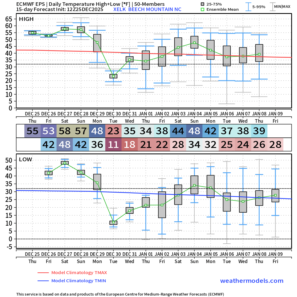
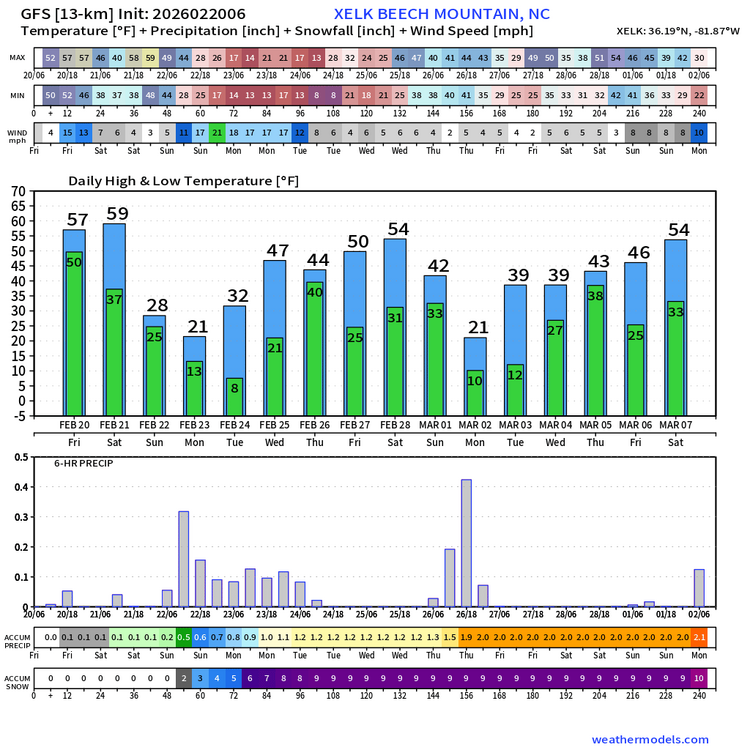
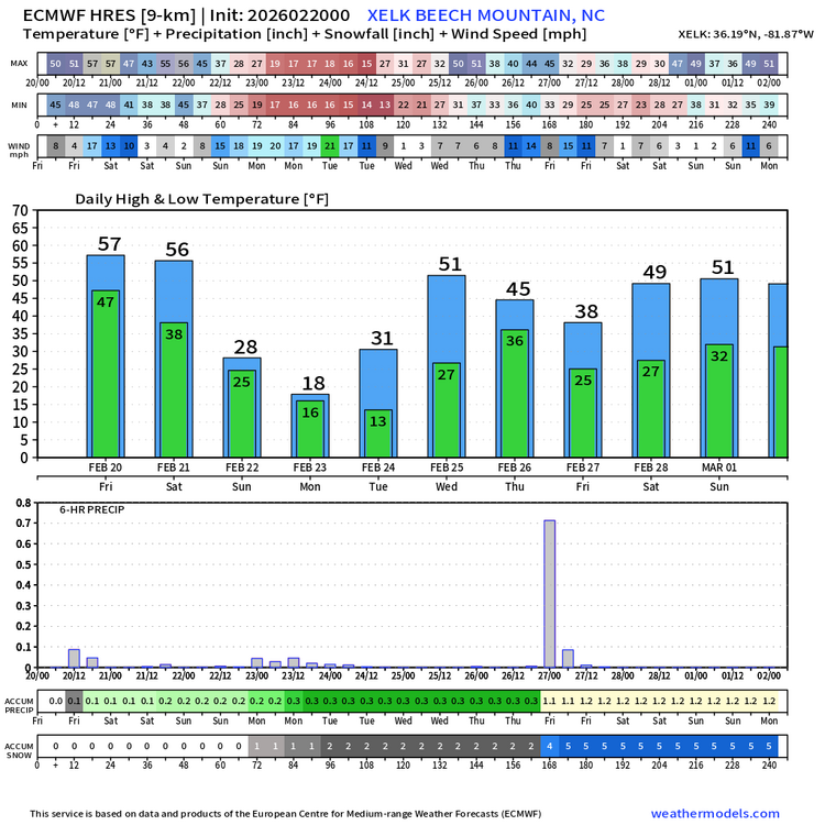
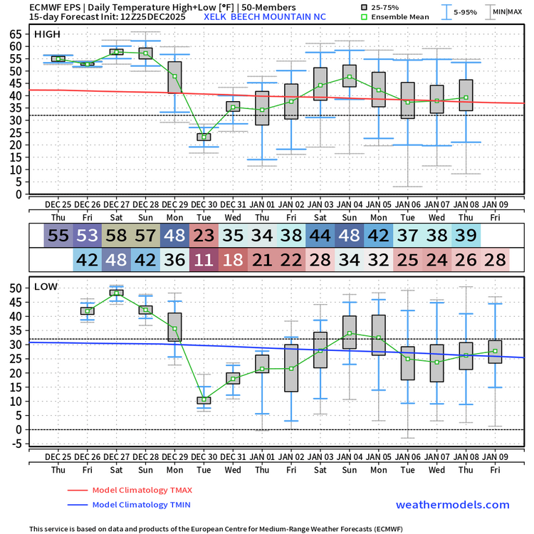
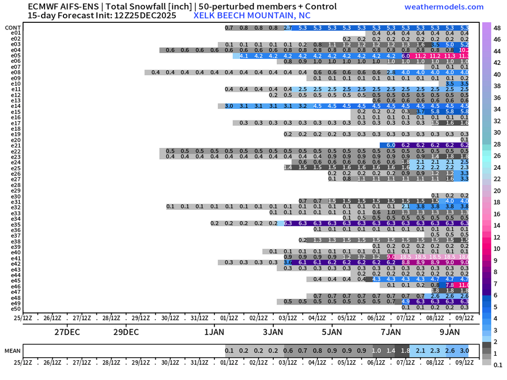
ECMWF EPS Next 10 Days
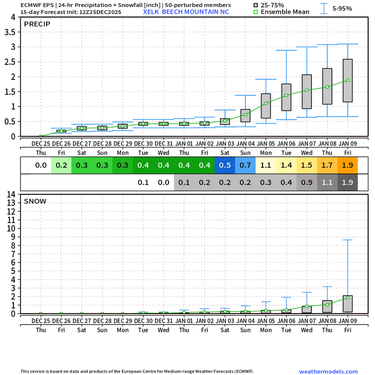
-
2025-2026 Fall/Winter Mountain Thread
nchighcountrywx replied to Buckethead's topic in Southeastern States
⚜ "Gloria in Excelsis Deo et in Terræ Pax hominibus bonæ voluntatis." May the peace, joy, hope and grateful blessings that only Christmas can bring, be yours for you and your family. Merry Christmas !
-
2025-2026 Fall/Winter Mountain Thread
nchighcountrywx replied to Buckethead's topic in Southeastern States
-
2025-2026 Fall/Winter Mountain Thread
nchighcountrywx replied to Buckethead's topic in Southeastern States
Courtesy of Thomas Mabry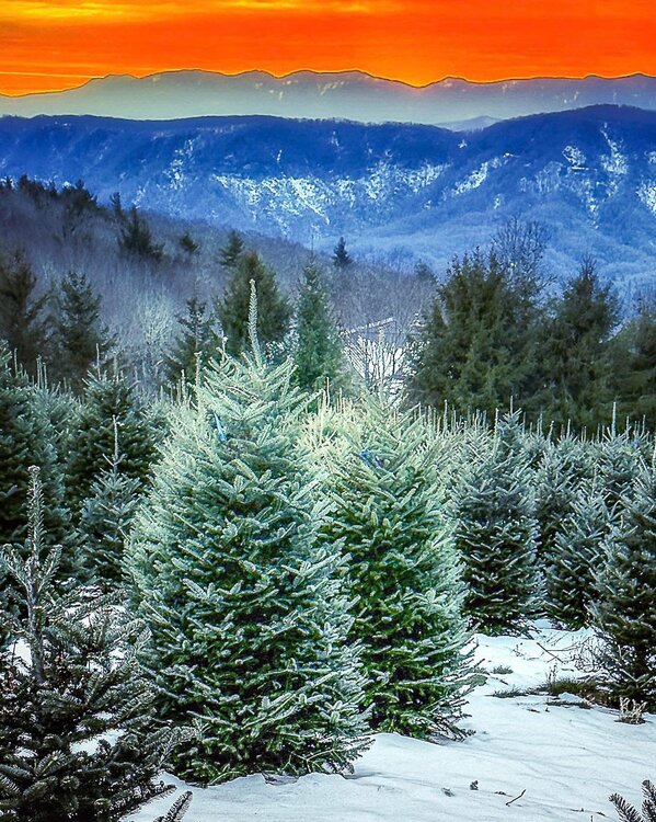
-
2025-2026 Fall/Winter Mountain Thread
nchighcountrywx replied to Buckethead's topic in Southeastern States
Grateful that we live in such a beautiful region of the state of NC. To God be the glory for all that he has made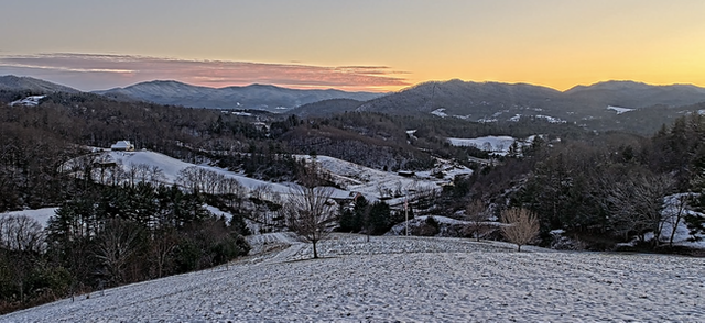
-
2025-2026 Fall/Winter Mountain Thread
nchighcountrywx replied to Buckethead's topic in Southeastern States
-
2025-2026 Fall/Winter Mountain Thread
nchighcountrywx replied to Buckethead's topic in Southeastern States
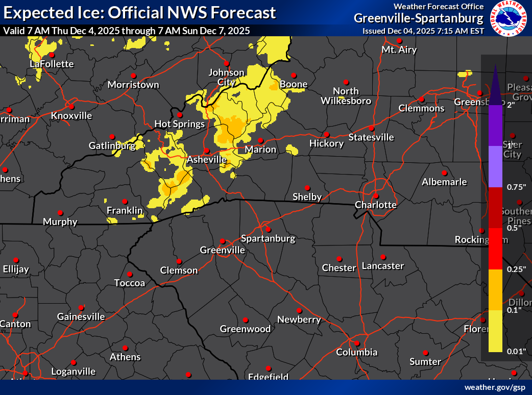
GSP 717am Updates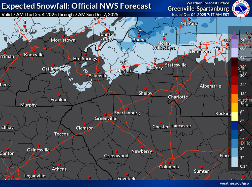

-
2025-2026 Fall/Winter Mountain Thread
nchighcountrywx replied to Buckethead's topic in Southeastern States
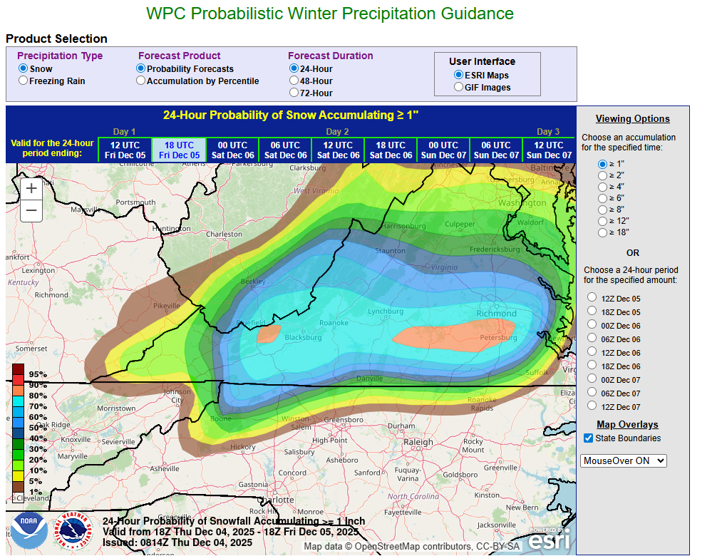
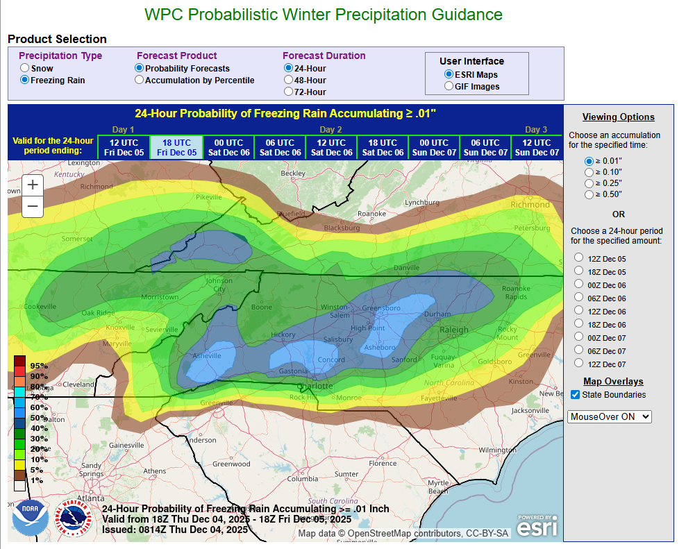
Good Morning. Referencing latest official guidance from WPC

-
2025 Spring/Summer Mountain Thread
nchighcountrywx replied to Maggie Valley Steve's topic in Southeastern States

-
2024-2025 Fall/Winter Mountain Thread
nchighcountrywx replied to Buckethead's topic in Southeastern States
32 years ago today -
32 years ago today
-
2024-2025 Fall/Winter Mountain Thread
nchighcountrywx replied to Buckethead's topic in Southeastern States
-
2024-2025 Fall/Winter Mountain Thread
nchighcountrywx replied to Buckethead's topic in Southeastern States
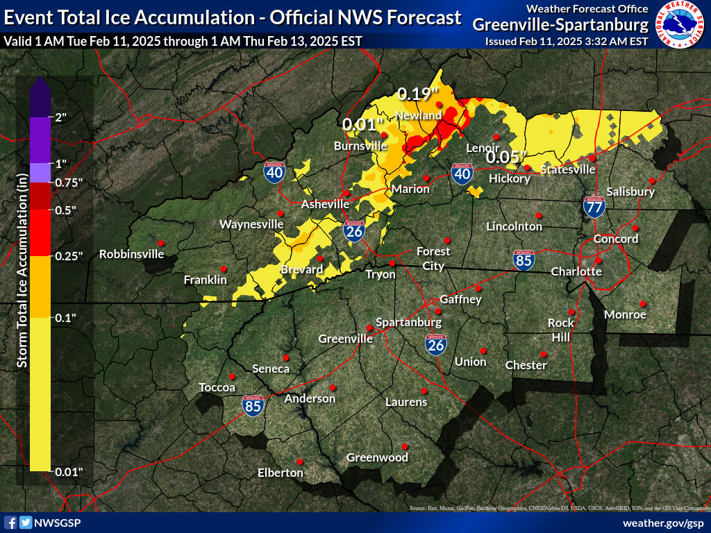
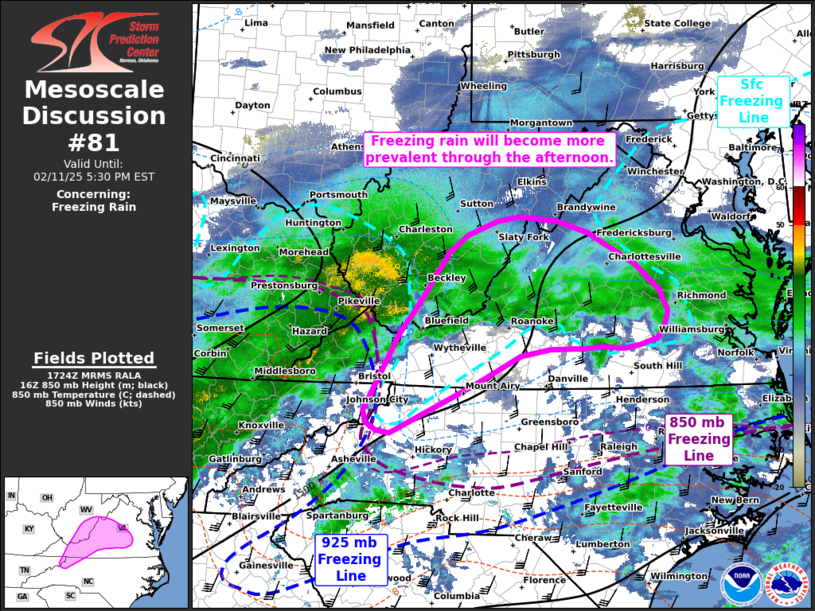
PRECIP RATES THROUGH THE DAY ARE EXPECTED TO BE TAME, WITH FORCING LIMITED TO RATHER SHALLOW ISENTROPIC LIFT. AS SUCH, ANY FREEZING RAIN SHOULD BE WELL WITHIN THE BOUNDARIES OF WINTER WX ADVISORY CRITERIA THROUGH THE DAYLIGHT HOURS. HOWEVER, PRECIP RATES WILL PICK UP THIS EVENING INTO THE OVERNIGHT, AS THE BAND OF FRONTOGENETICAL FORCING SHIFTS EAST. THIS IS WHEN THINGS COULD GET INTERESTING IN TERMS OF ICE ACCRETION ACROSS THE BLUE RIDGE AREAS OF THE NORTHERN MOUNTAINS. TEMPERATURES ARE EXPECTED TO GRADUALLY WARM THIS AFTERNOON/ EVENING, AS THE PARENT HIGH WEAKENS AND MOVES OFF THE COAST. HOWEVER, THE SURFACE PATTERN ACROSS THE NORTHERN CONUS AND SOUTHERN CANADA IS ACTUALLY RATHER COMPLEX, WITH TWO ANTICYCLONES EMBEDDED WITHIN A BROADER RIDGE. ONE OF THESE WILL BE STRENGTHENING (TO > 1030 MB) AND LOCATED SOUTH OF HUDSONS BAY BY 00Z WED...I.E., MOVING INTO AN INCREASINGLY FAVORABLE POSITION FOR REINFORCING THE CAD. THEREFORE, IT'S NOT AT ALL CLEAR THAT LOCATIONS ALONG THE NORTHERN BLUE RIDGE...ESP EAST OF THE CONTINENTAL DIVIDE WILL WARM ABOVE FREEZING BEFORE THE HEAVIER PRECIP RATES ARRIVE. AS A CONSEQUENCE, IT'S ENTIRELY POSSIBLE THAT A NARROW AXIS OF DAMAGING ICE (.25-.5") WILL DEVELOP ACROSS EASTERN AVERY COUNTY AS WELL AS FAR SOUTHERN MITCHELL/YANCEY, AND AREAS ABOVE ~2500' IN MCDOWELL/BURKE/CALDWELL. AFTER COLLABORATION WITH NWS BLACKSBURG, THERE IS ENOUGH CONFIDENCE IN THIS SCENARIO TO UPGRADE TO AN ICE STORM WARNING IN AVERY AND BURKE MOUNTAINS. FOR THE REST OF THIS AREA, CONFIDENCE IS NOT AS HIGH THAT ENOUGH OF THE FORECAST ZONE WILL SEE WARNING CRITERIA TO WARRANT AN UPGRADE, BUT WORDING TO THIS EFFECT WILL BE MENTIONED IN THE UPDATED ADVISORY. OTHERWISE, NO CHANGES ARE PLANNED TO CURRENT HEADLINES. OUTSIDE OF THE NORTHERN MOUNTAINS, THE REMAINDER OF THE ADVISED AREA SHOULD SEE UNDER 0.1" OF ICE, WITH ONLY MINOR TRAVEL DIFFICULTIES EXPECTED OWING TO MARGINAL TEMPS AND WARM ROADS. -
2024-2025 Fall/Winter Mountain Thread
nchighcountrywx replied to Buckethead's topic in Southeastern States
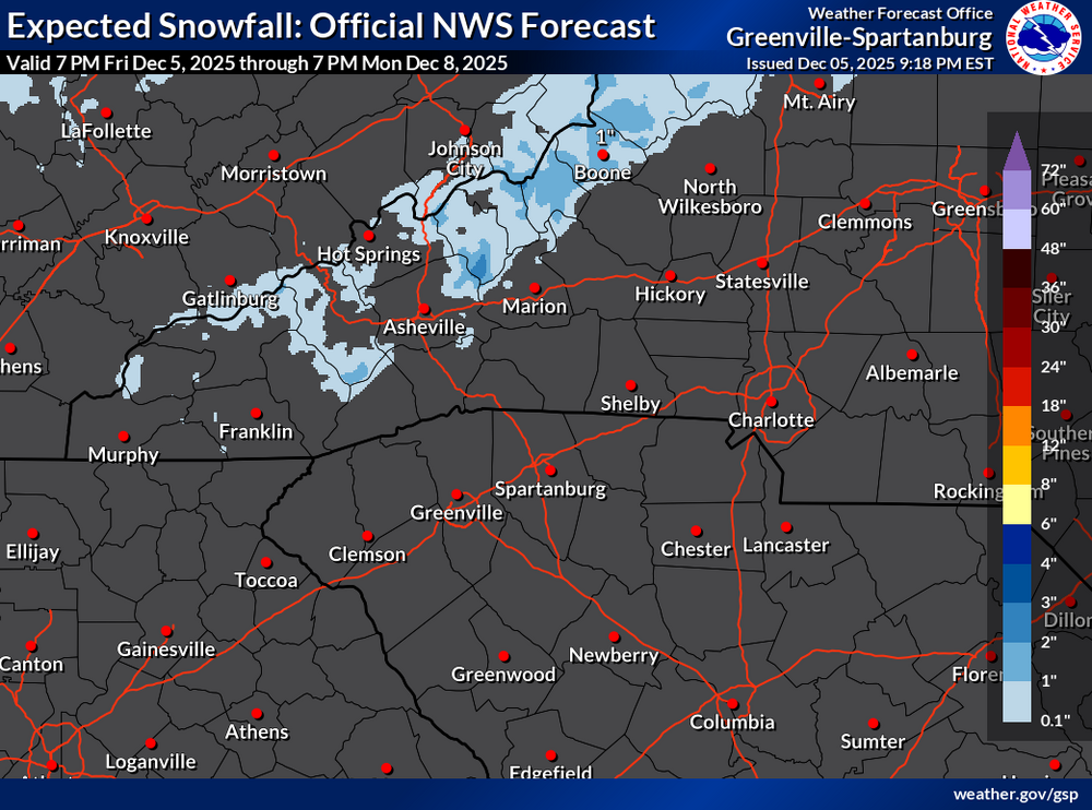
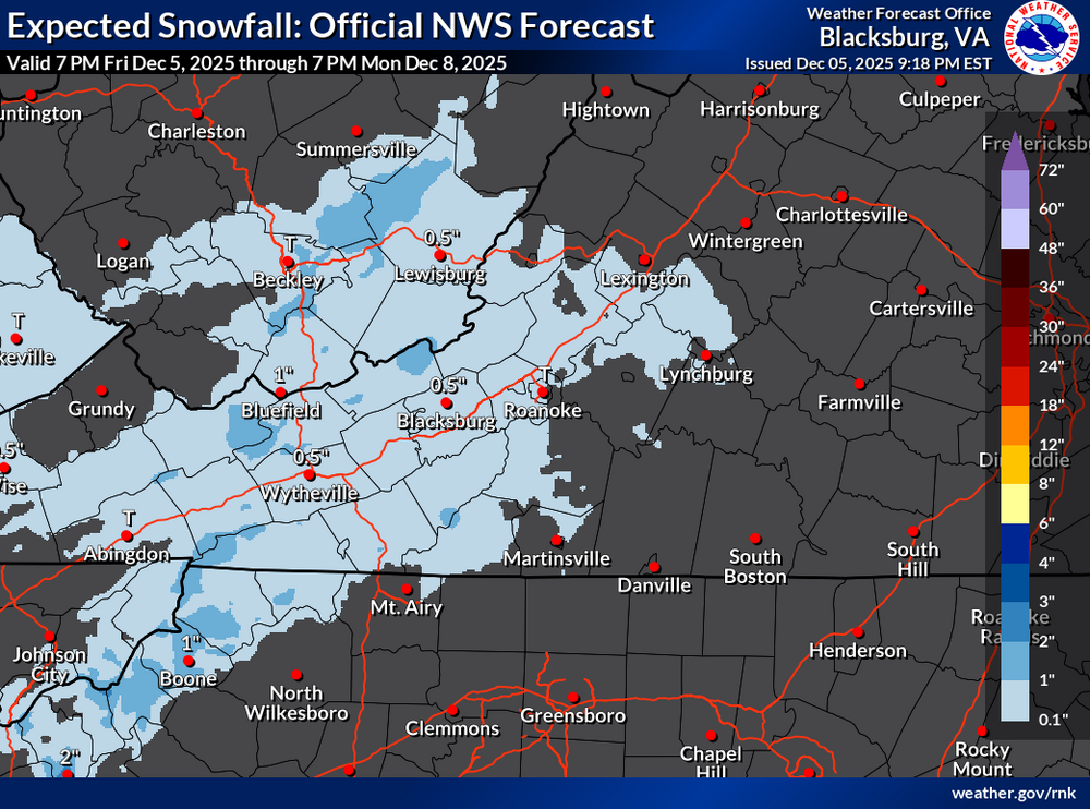
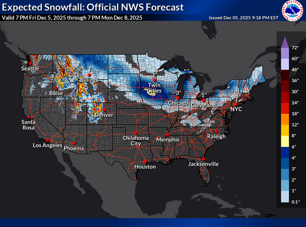
Guidance from GSP…
-
2024-2025 Fall/Winter Mountain Thread
nchighcountrywx replied to Buckethead's topic in Southeastern States
-
2024-2025 Fall/Winter Mountain Thread
nchighcountrywx replied to Buckethead's topic in Southeastern States
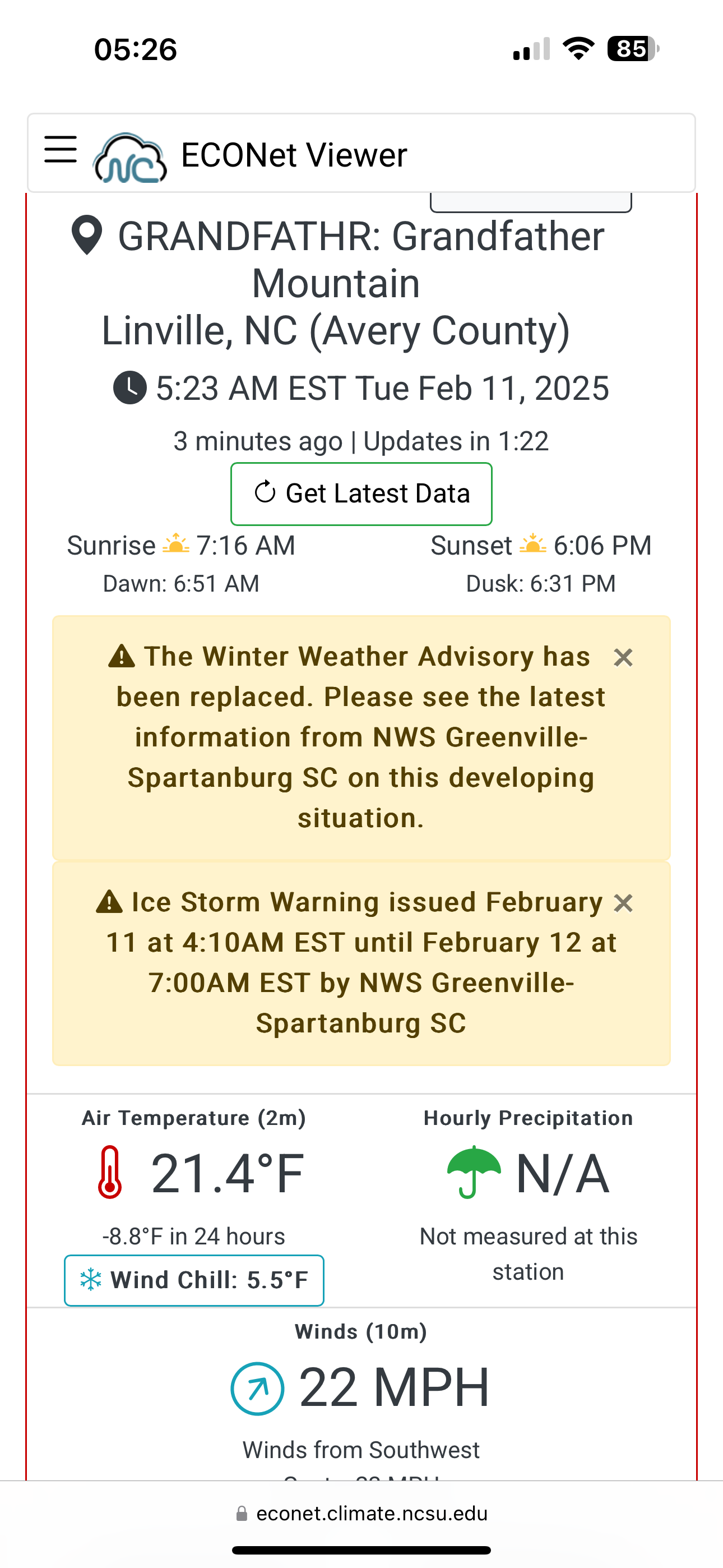
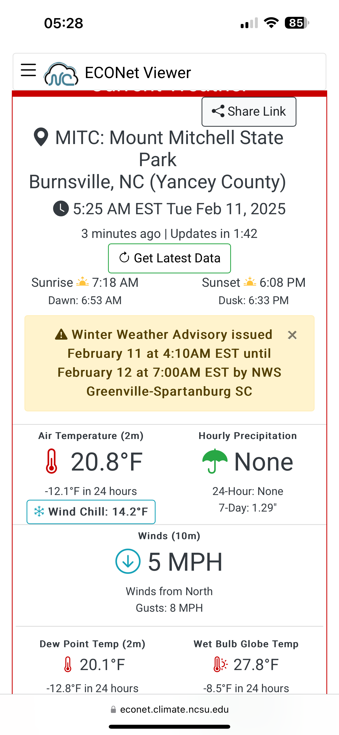
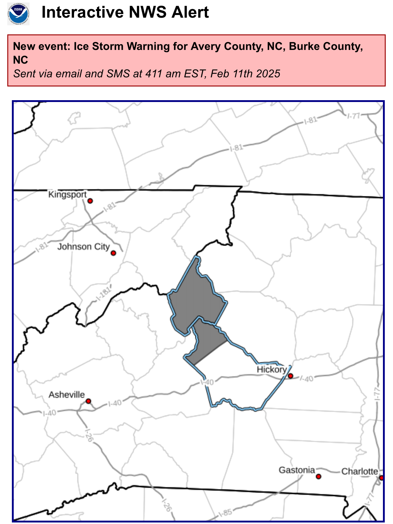
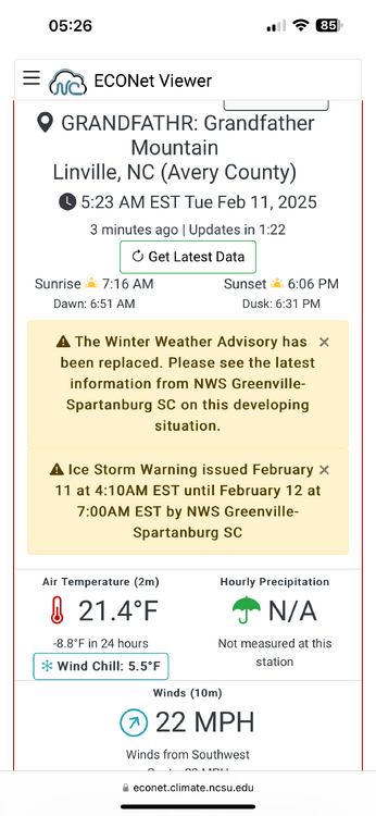
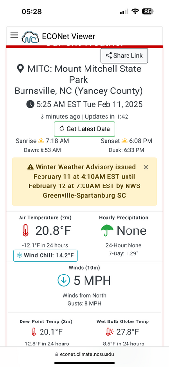
Ice Storm Warning https://inws.ncep.noaa.gov/a/a.php?i=109304611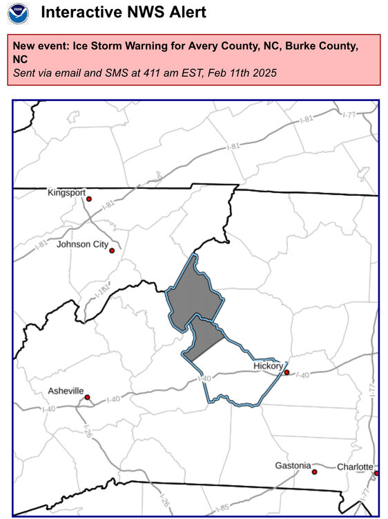
-
2024-2025 Fall/Winter Mountain Thread
nchighcountrywx replied to Buckethead's topic in Southeastern States
All in one place images: https://www.weather.gov/gsp/winter#tab-6