

SnowGoose69
-
Posts
16,758 -
Joined
-
Last visited
Content Type
Profiles
Blogs
Forums
American Weather
Media Demo
Store
Gallery
Posts posted by SnowGoose69
-
-
4 minutes ago, weatherpruf said:
there was no snow in central jersey for that one iirc......it was mainly south. or was that feb? in any case, there was no significant snow as it was my second year teaching and the only snow day we had was for the snowless wonder that winter where not a single flake fell.....i did not get my first actual snow day until the super storm of 93, but that's partly because the board in elisabeth were a bunch idiots. in 89 actually i was in jackson, where everyone was bussed so they called school ' on the 7th snowflake ' or as i noted, merely the threat of snow.....biggest bust until march 2001....
TTN had only 3.5, if I remember right it began snowing around 12-1 and was a Friday so it’s likely nobody bothered to close. I do believe it overperformed forecasts too.
-
Some similarities to 1/6/89 with this storm. Produced about 4-7 inches across the area in a -PNA pattern. BDL/BOS/PVD all got shutout.
-
1 minute ago, The 4 Seasons said:
Yeah i was looking at this recently because im getting ready to work on the 94-95 season. NYC got 10.8" from that storm and 11.6" all winter total. If it werent for that storm they would have had 0.8" on the winter, which would have made it, by far the worst season in history. Along with a lot of other climo sites, it would have been the worst winter ever including ORH.
That was just a wild winter, such a crazy +AO/NAO fairly far removed from the solar max and also in a weak to moderate El Nino.
-
RRFS is a squashed mess at 84, looks like if you extrapolate it we'd barely get a thing. That said, it was a squashed mess at 84 with today's system too. Maybe a bias of the model? Will have to see where we are in 3 days but its interesting to see it do the same. If we want to take its idea as gospel and assume same thing happens, something exactly like the Euro would happen.
-
 1
1
-
-
15 minutes ago, Terpeast said:
At least Webb admitted to the L. I’ll give him that.
There were a couple of ways I felt we’d head in early January. One was we’d gradually transition to something more +PNA and favorable for 2-3 weeks. The other was we’d lose the WPO/AO/NAO and it would go ugly for at least awhile if not most of the rest of the way. Some years in similar groupings of analogs did see that happen. Right now it looks like we’ll avoid that. The weeklies showing the same pattern for like 6 weeks into late January as recent as 5-7 days ago as we discussed somewhat was always unlikely as it feels as if the last 15 or so years we never hold any pattern in the winter for more than like 3 weeks anymore
-
1
-
-
7 minutes ago, 40/70 Benchmark said:
Welcome to November, Mr. Webb...happy to have had you join us.
+PNA January...book it.
The L that I will take is on the latter December/early January NAO block....missed that.
May depend on how negative it is early. I’m still not confident we see it go positive consistently til like 1/12-1/15 outside of what might be a brief transient positive phase coming up in a week or just under that. If it averages only like -1 to -1.5 the first 12 days of the month it could probably end up positive in the end on the means
-
7 minutes ago, North and West said:
Can’t believe I’m saying this, but does a storm like this give 1994 vibes to the old timers here? Just the unusualness of it, if it occurs.
.Nothing ever took that funky track but these were back to back overrunning events, first one was all snow, 2nd one was mixed.
https://www.meteo.psu.edu/ewall/NARR/1994/us0126.php
-
1
-
-
Neither the AI or Op GFS changed much from 12z
-
1
-
-
2 minutes ago, brooklynwx99 said:
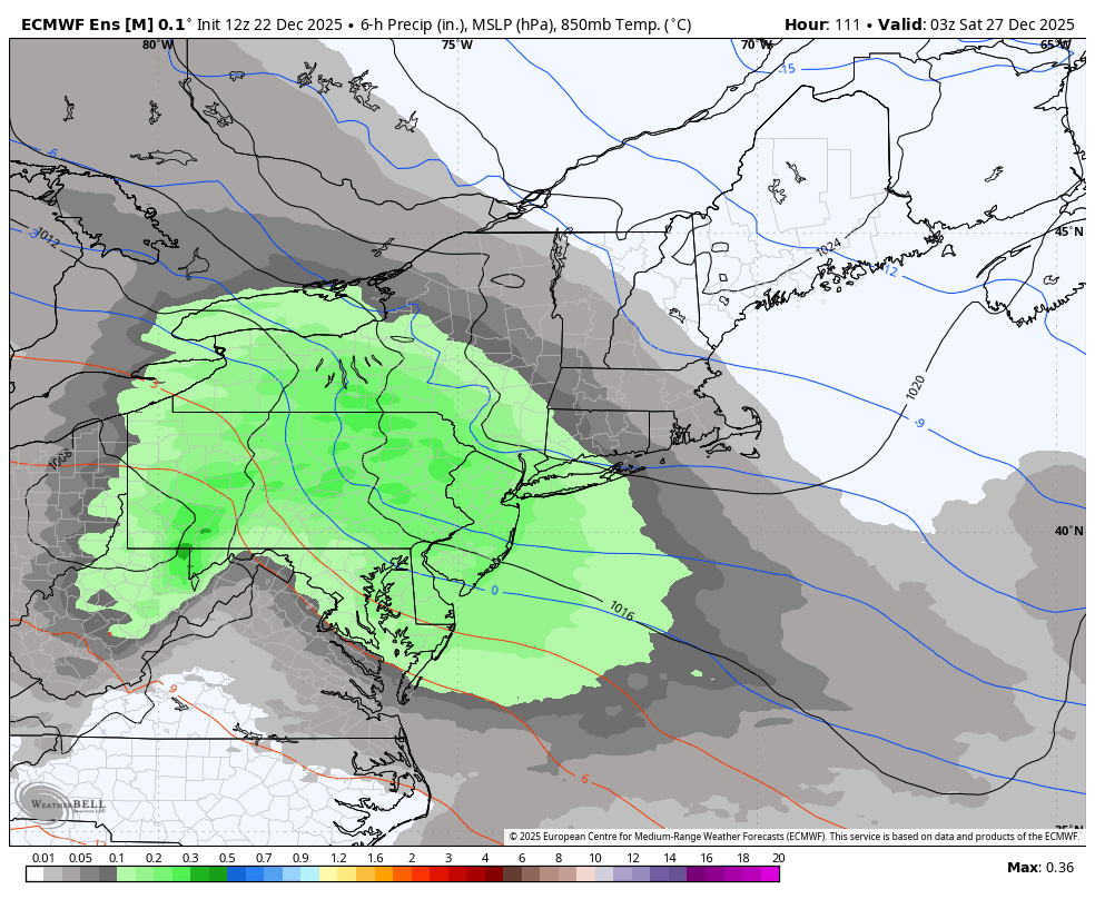
EPS continues to tick colder. mean is about 4" for NYC
i generally like this kind of event... shove moisture into HP and you usually have success


We had a bunch of these in 93-94, I feel we've had basically none since minus PDII
-
5
-
-
26 minutes ago, donsutherland1 said:
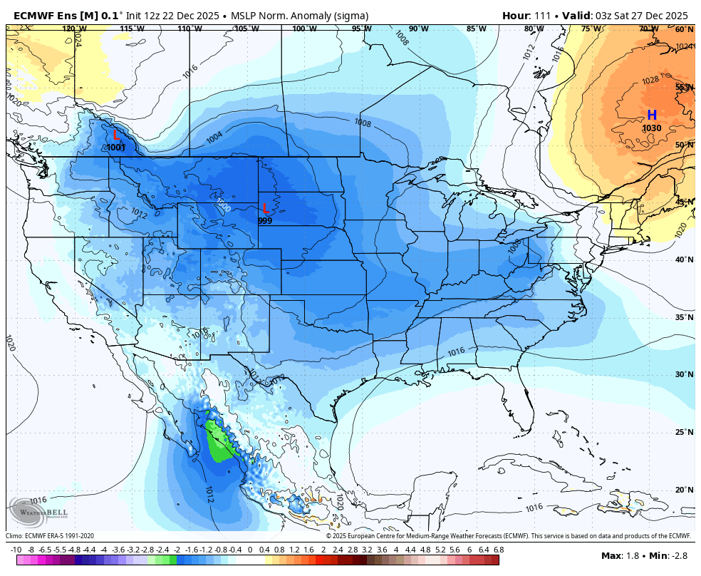
I agree concerning a miss to the south. The historical odds would favor something further north than what the recent runs of the GFS have been showing. It should also be noted that most storms during PNA- patterns have lighter amounts.
Many options are on the table, including a weak, sheared out primary that produces very little precipitation. Let's see how things evolve.
Yeah I still think less juicy and more north is likely. I could see SN/PL/FZRA in NYC. I am not highly confident in this range at the metro being mostly snow at all. I don't like the -PNA and think the pattern upstream over the N Plains/MW will allow this to probably gain too much latitude before its shunted.
-
2
-
-
1 minute ago, Krs4Lfe said:
Should be nice to look at as it falls but I would imagine it will all melt within a day or so. North and west of NYC might have enough to stick around until Christmas but NYC barely sticks even on a colder day Hopefully NYC can squeeze out one inch and get to the magic 4” mark for December
The temps did go to hell on this from what the models showed 3 days ago which is not surprising since it was always going to be a SW flow event in the low levels. I think its a case where you need it to be snowing by 8-9z. The longer you allow the DPs to rise on the SW flow the harder it will be to get down to 32-33 and get accumulation.
-
5 minutes ago, NittanyWx said:
I'm in the camp that risks with Boxing day event point towards more suppression vs P-type actually.
We have a pretty strong split this morning on social media as well as through friends who are Mets on the potential. I think about half say this could become a SNJ/SE PA mostly event and others saying this is a BDL/BOS bullseye. I do think even if we lean towards suppression its likely a fringer here and a bullseye in Philly. I don't know if this is Virginia special territory really.
-
1
-
-
3 minutes ago, 40/70 Benchmark said:
It will probably end up like a situation where it will come back enough for CT, but I'll be bent over before the next MHT points north event hits.
I'd feel pretty good in most of SNE at this time. I'm trying to talk off people in NYC/PHL that I don't think this can really get far enough south for them to be all or even mostly frozen. Despite the block I don't like the upstream setup really to get this to be a northern MA event.
-
1
-
-
6 minutes ago, RU848789 said:
12Z NAM12km, NAM3km, FV3 and RGEM all show 1" or more along and N of 78, including for NYC. We might get an overperformer if we're lucky.
They're all sloppy with the QPF fields...if that ends up being more a consolidated WAA snow shield we may see this overperform. Once again though the NAM was pretty bad with this til we got inside 36. I've been saying for awhile now, avoid that model beyond 36, sometimes it does okay 36-48 but often time its the final day or day and a half where its reliable.
-
1
-
-
4 minutes ago, MJO812 said:
Icon slightly more south

.thumb.png.6ada4ab833eeefeca8bf4b1b665befca.png)
That is about my guess for the moment on what happens. I think it'll be extremely hard to get this to be heavily frozen this far south.
-
The EPO/PNA still suck in the long range, so it won't be going January 94/85 February 2015 anytime soon but the location of the PV being on this side of the pole will mean it can easily get cold enough for snow and the -PNA means we are not in a bone dry pattern. The AO/NAO have the look of not wanting to consistently stay strongly - or + so far for more than 7-10 days and often times if thats your trend through 12/31 it stays that way all winter so those 2 may largely be non major factors. The PNA/WPO/EPO at some stage likely go through a major reversal of where they've been in the next 20-30 days and that probably decides what the 1/15-3/10 period is
-
1 hour ago, SHELEG said:
GFS is so far south it’s a miss.
Yeah that definitely won't happen. I'd still lean towards this probably being too far north for anything here, but there is potential now for something when 2-3 days ago there was none.
-
32 minutes ago, 40/70 Benchmark said:
January is going to be +PNA and the season will average -WPO....very strong statistical evidence.
The 18Z GEFS for the first time from like 360-384 shows signs of a +PNA trying to develop but I'd bet its close to the 12th-15th before any chance of it
-
1
-
-
1 minute ago, Sey-Mour Snow said:
LOL the replacement for NAM and HRRR: RRFS is a toaster bath for most of this forum.. It ticked SW another 35 miles from 12z.. It has 1-3" for SWCT down to central jersey and shutouts everyone else.. RRFS did really good with the last storm, so it has my attention.. It will have to earn our respect though..
I have not followed it beyond 48-60 with storms so far. I do know its had a bias of being too warm aloft, so basically the reverse of what the HRRR bias is
-
1
-
-
1 hour ago, qg_omega said:
NYC needs 0.2 to go above 3 inches, Kalshi odds only 45 percent for December. Seems low to me
I’d give them a decent shot now but we got a ways to go. This system will probably have two maxes. The area that gets hit from the initial warm advection and clipper and then from the developing surface low offshore. Someone in between will get the shaft. Right now the prime shaft zones may be places like central MA down through CT and central to eastern LI. It’s a case where Morristown could see more snow than New Haven
-
21 minutes ago, Stormlover74 said:
Its coming overnight with temps around freezing. Should be able to squeeze out an inch or so at central park before ending as drizzle. Unless the whole thing trends north. Still 3 days to go
I've not seen us get snow this far south with a clipper that far north that I remember. But its sort of a case of perfect timing here where it comes in after a fairly cold airmass is on its way out so you get overrunning snows. Its somewhat similar to 12/27/84 though that was more just a mid or upper level wave inducing overrunning snows than it was a clipper/warm front feature. It shows you how snow is often more luck than anything else and how in -PNA patterns it is easier for us to get lucky than +PNA ones where its more often boom or bust nowadays.
-
1
-
-
RRFS congrats NYC lol. Would not trust it at this range though
-
RRFS is ridiculously south. Probably can toss that. I have not looked at it much past 48 but it seems less wacky and ugly overall than the NAM does beyond that period most of the time so I guess good news there as far as improvement with the new model
-
1
-
-
The NAM appears to have NAM'd. ICON/RGEM are about what I'd expect. I think the Euro is a tad too far south with this right now.
December 2025 OBS and Discussion
in New York City Metro
Posted
I feel as if NYE is always 20 or 55, no in between, at least since my memory goes back