

SnowGoose69
-
Posts
15,271 -
Joined
-
Last visited
Content Type
Profiles
Blogs
Forums
American Weather
Media Demo
Store
Gallery
Posts posted by SnowGoose69
-
-
I checked Palm Springs daily precip records for 8/20 8/21 8.22 0.23 T 0.24
 Strangely enough Las Vegas all time daily record for August is 2.58 on 8/21...that may not get broken
-
 1
1
-
-
Just now, NJwx85 said:
Don't they see significant rains during monsoon season on a regular basis?
They do but for maybe 30-45 minutes, and even .30-.40 in that span can flood hotels/etc. I think if they saw a day with several inches and periodically saw amounts over .50 in an hour they'd have big issues
-
Vegas might shutdown for like a week if they see even 2-3 inches of rain
-
1 minute ago, NJwx85 said:
The latest HRRR says otherwise.

Tonight may be bad but I don't see much happening Tuesday night or late day
-
 6
6
-
-
38 minutes ago, wishcast_hater said:
How is the weather looking for Tuesday evening? I'm going to the Guns N' Roses concert and don't want a rain out.
Does not look bad unless you are down in SNJ. I think the convection here would depend on needing to develop near the surface low feature and would be later in the evening maybe 9pm-12am. I am not confident much fires at all on the front
-
2
-
 1
1
-
-
Taking the current radar as gospel the metro and LI could get squawked but chances are with the instability we have this will consolidate.
-
This should effectively move up the entire timing for everyone. Probably done in the city by 2 and most activity after that to the east
-
2
-
1
-
-
7 minutes ago, TWCCraig said:
Smoke returns to the skies starting Monday according to the RAP. I hate this stuff!
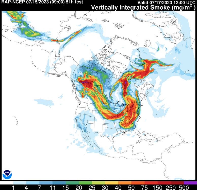
I don't think its a sustained enough NW flow pattern for it to really hang around long though or in high concentration near the surface. I think the worst of it remains west.
-
1
-
-
18 minutes ago, lee59 said:
See lightning to my Northwest, probably about as close as I'll get to the rain
Stuff is trying to pop on outflows now from Brooklyn into Nassau
-
Sharp gradients in Nassau now..70-72 by Merrick Road...80 around the SSP...82-85 from there to the NSP then 85-89 north of that
-
10 minutes ago, bluewave said:
The Euro weakens the -PDO. But since it is now close to a super El Niño, we would have to deal with that warmth. So it will be interesting to see how it goes.
April run much stronger

March run weaker

New April run weaker -PDO

Hard to believe it’ll be that strong. Last I checked the consensus on the ENSO models was mostly around 0.8-1.0
-
1 hour ago, LibertyBell said:
One thing I am puzzled about, with the Gulf Stream warming so much how come we haven't seen a hurricane like Hugo hit us (not that I want that of course, but that was a hurricane that warmed up rapidly because of the Gulf Stream.) Hurricanes still seem to rapidly weaken before they get to our region.
You need a stupidly odd pattern to really get a Cat 3 or 4 up here and even then its probably likely to be a warm seclusion type thing which many now think 1938 was. It has to be a case of a trof over the lakes interacting with a strong ridge where the system is pulled N or NNW because anything else will want to bend NNE naturally as it comes north and any storm which is near or touches the NC coast will usually weaken and be west of the warmest Gulf stream waters.
-
7
-
-
Its hard to say if the NATL SSTs are solely responsible for that change though, there may be some other factor we just are not aware of which is leading to it. I know many in the meteorology world argue that SSTs really do not impact atmospheric heights and that its an overblown theory...we see this in the GOA every year when the argument breaks out whether its the chicken or the egg
-
5
-
1
-
-
Will be interested to see if the Mets wimp out and postpone Thursday or not...models have not budged from a 4-6pm arrival on that front really which is late enough to not impact the starting pitcher but the Yanks canned opening day last year 24 hours out given the open date available as is customary...could see Mets just doing the same. I'm not sure why the Euro seems so enthused with convective potential relative to other models. I am not impressed with the instability overall
-
2
-
-
5 hours ago, MANDA said:
Anyone taking bets on when we next get a below normal month temperature wise around here?
We're 3 for 3 above normal for the year so far. Below normal months are getting so rare. Even if they are below normal it is barely below.
If we get a decent El Niño it’s highly likely October will average below normal but even summers can be below normal during El Niño here so don’t be shocked if one of June July august is
-
1
-
-
Could be dare I say some inland 80 plus highs late next week if ensembles are right and it’s not showery or overcast. That second part is a big if now
-
1
-
-
Those hoping for the Central Park record we need big time help right now lol. Unless we have a nasty bust on the short range models they’re gonna get 0.6 I think on a snow board with trees around
-
2
-
 1
1
-
-
The HRRR at hour 18 is markedly less stupid over SNE with low placement than the 18Z HRRR run was at hour 22 so maybe its beginning to get an idea. I could see 00Z runs finally agreeing for the most part
-
What probably is going to happen is when this thing finally organizes tonight the 06 and 12Z runs will all finally agree and be similar
-
That NAM run would not be bad even down this way if we were like 5 degrees colder
-
1
-
-
2 minutes ago, Winterweatherlover said:
I would not be surprised if southern Rockland and most of Westchester get no accumulation at all. It depends on temps and rates tomorrow morning.
The dewpoints are fairly good on the models tomorrow late AM into the afternoon...if somehow some way there is a steady light snow I think those areas will easily fall to 30-32 tomorrow afternoon...the DPs and air mass in place to the north with the last event did not have that
-
That 18Z HRRR was hilarious for ERN MASS...that would be quite a blown forecast
-
The bust potential across most of CT is really big with this because if the models are even slightly wrong on the idea of that secondary low signature being too strong those areas will probably get alot more snow
-
2
-
-
Well...this might tell you where the NWS is headed in their afternoon update for the Hartford area lol...
TERMINAL FORECAST
BDL NWS 131730 KBDL 131727Z 1318/1424 12010KT P6SM VCSH BKN026
OVC040
FM132000 11009KT P6SM -RA OVC015
FM132200 09009KT 1 1/2SM -RA BR OVC008
FM140800 04014G23KT 1SM RA BR OVC008
FM141200 03018G31KT 3/4SM -RA BR OVC008
FM141500 01021G35KT 1/2SM -RA OVC008
FM142000 35023G38KT 3/4SM -RA BR OVC008-
4
-
 3
3
-

Hurricane Hilary
in Tropical Headquarters
Posted
Palm springs has had .97 the last hour and a half