
AnEndlessMaze
-
Posts
5,316 -
Joined
-
Last visited
Content Type
Profiles
Blogs
Forums
American Weather
Media Demo
Store
Gallery
Everything posted by AnEndlessMaze
-

Southern MD / Lower Eastern Shore weather discussion
AnEndlessMaze replied to AnEndlessMaze's topic in Mid Atlantic
It looks like our region is about to get T-stormed pretty good... reds and yellows on radar over St Mary's county now. Edit: Heavy showers here now with thunder -
Southern MD / Lower Eastern Shore weather discussion
AnEndlessMaze replied to AnEndlessMaze's topic in Mid Atlantic
12z GFS moved it all north/west and gave us the classic fringe job... rain for us. -
Southern MD / Lower Eastern Shore weather discussion
AnEndlessMaze replied to AnEndlessMaze's topic in Mid Atlantic
Most of the eastern shore of MD/DE got GFS'ed last night for this Friday... southern MD got sorta GFS'ed too lol -
Southern MD / Lower Eastern Shore weather discussion
AnEndlessMaze replied to AnEndlessMaze's topic in Mid Atlantic
Yep, I'm not sure we're completely done this winter... -
All these records were indeed broken. Edit: Actually it was 3/6 and 3/7
-
Southern MD / Lower Eastern Shore weather discussion
AnEndlessMaze replied to AnEndlessMaze's topic in Mid Atlantic
I think I'm going to go with 6.5". You had 6", trained spotters in Hungtingtown, Dowell and California had 6.1", 6" and 6.5", respectively, and most of the measurements I took now are giving me around 6.25-6.5" even after compaction (we had some light snow again late last night it seems). Either way, it puts me over climo- my two winters in Prince Frederick have both been above average snow now! Great song to listen to while looking at the full moon over the newly fallen snow last night: https://www.youtube.com/watch?v=OU2_mQMZFZw -
Southern MD / Lower Eastern Shore weather discussion
AnEndlessMaze replied to AnEndlessMaze's topic in Mid Atlantic
Well, I have a discrepancy now. My usual snow measuring spot was about 5.5" which seems too low and it appears snow drifted away. My neighbors yard is a consistent 7.5-8" inches everywhere which is definitely too high and it appears snow drifted into her yard. All other measurements I've taken in various spots have been within that range (between 5.5-8"). I did measure 4" this afternoon. I'll see what other totals are in my area but for now I'm thinking of calling it 6" or 6.5" just to average it out. Anybody from Calvert, please post your snow totals so I can compare! Tried to take a Jebwalk but it was too cold and windy! -
Southern MD / Lower Eastern Shore weather discussion
AnEndlessMaze replied to AnEndlessMaze's topic in Mid Atlantic
I see that yellow on radar under you. Both of us could be in the game for a few more hours I think, if the moisture keeps sliding west to east like it currently is on radar. -
Southern MD / Lower Eastern Shore weather discussion
AnEndlessMaze replied to AnEndlessMaze's topic in Mid Atlantic
4 inches so far and still snowing hard. -
Southern MD / Lower Eastern Shore weather discussion
AnEndlessMaze replied to AnEndlessMaze's topic in Mid Atlantic
As I said in the main thread, I can definitely call this heavy snow. Can't see the power lines that are only 1/4 mile away from my house. Roads and everything are covered. If this keeps up through the evening the LWX calls will verify. -
Southern MD / Lower Eastern Shore weather discussion
AnEndlessMaze replied to AnEndlessMaze's topic in Mid Atlantic
Its happening! Moderate snow finally. -
Southern MD / Lower Eastern Shore weather discussion
AnEndlessMaze replied to AnEndlessMaze's topic in Mid Atlantic
Oh I know, I don't take them seriously. There seems to be a lot of NoVa weenies who just pop up every storm now with these type of obs. LWX isn't blinking- in fact, they've doubled down for my area. I've been upped to 6-8". I think, based on obs I've seen, that the screw zone is just south of northern Calvert. Still rain/sleet here. -
Southern MD / Lower Eastern Shore weather discussion
AnEndlessMaze replied to AnEndlessMaze's topic in Mid Atlantic
Its sleet here now. Its always ripping and tearing SN+++ obs from some people in the main thread, every storm. -
Southern MD / Lower Eastern Shore weather discussion
AnEndlessMaze replied to AnEndlessMaze's topic in Mid Atlantic
Nothing but rain so far, but my guage says we've had 1.13" for this event. It rained hard here last night, but its only a light drizzle now. 41 degrees. Snowpack is mostly gone. I'm gonna stay away from reading or posting on the main thread until it starts to turn over to snow here, cause I know I'm gonna get pissed off reading everyone's snow obs north and west when it hasn't turned over here yet. -
I didn't realize BWI had a low-hanging-fruit daily snow record for 3/5- only 4.0 inches (days before it and after it are much higher). We'll probably break that if everything goes as planned. Also, record low watch for 3/5 and 3/6.
-
Southern MD / Lower Eastern Shore weather discussion
AnEndlessMaze replied to AnEndlessMaze's topic in Mid Atlantic
Debating if its too early to build a St. Patrick's Day themed snowman (I did one last year on the St. Patrick's Day storm). It would only be 12 days away. But then what happens if we get a repeat on 3/17/15? Decisions, decisions... Edit: actually I'd build it on the 6th, so only 11 days away. Hmmm... -
Southern MD / Lower Eastern Shore weather discussion
AnEndlessMaze replied to AnEndlessMaze's topic in Mid Atlantic
Ok, I got a big forecast round-up. This is for both sides of the bay. Quite a bit of spread in these forecasts: TWC: 3-5" everyone. Accuweather: 3-6" Calvert and Charles, 1-3" St. Mary's and all of the lower eastern shore. DT (1st call): 6-10" for most of us, with a 10"+ blob that reaches parts of northeast Calvert and all of DE LWX: 4-6" for Charles, Calvert and northern half of St. Mary's. 3-4" for southern half of St. Mary's. CWG: 4-7" for for Charles, Calvert and northen half of St. Mary's. 1-4" for southern half of St. Mary's and the lower eastern shore. Justin Berk (first call): 6+ inches northern half of Charles and Calvert, Ice and 3+ inches for southern half of Charles and Calvert, all of St. Mary's, Dorchester, Salisbury and southern DE. Ice and 1-3" south and east of Salisbury. Ava Marie (WBAL): 6" in Charles, 7-8" everyone else. Ellinwood: Mostly 4-8", with lower St. Mary's (around NHK) and anything south of Salisbury in 2-4" -
Southern MD / Lower Eastern Shore weather discussion
AnEndlessMaze replied to AnEndlessMaze's topic in Mid Atlantic
Early forecast round-up for us: TWC: 3-5" for most of us, but nothern half of Charles, Calvert and Dorchester (and all of DE) crossing the line to 5-8" LWX: 4-6" for all of southern MD Ellinwood: Mostly 4-8", with lower St. Mary's (around NHK) and anything south of Salisbury in 2-4" -
Best Mid-Atlantic winter storm of the last 50 years
AnEndlessMaze replied to AnEndlessMaze's topic in Mid Atlantic
ummm.... it was supposed to be within the last 40 years lol -
Best Mid-Atlantic winter storm of the last 50 years
AnEndlessMaze replied to AnEndlessMaze's topic in Mid Atlantic
3/5/15? lol Just an excuse to bump one last time this winter, so get your votes in. -
Southern MD / Lower Eastern Shore weather discussion
AnEndlessMaze replied to AnEndlessMaze's topic in Mid Atlantic
Have to agree with others on here that I'm wary of a situation where we have to thread the needle and time cold air in early March- keep thinking about the 3/6/01 and 3/6/13 busts, although this is a completely different setup from either one of those. But I don't just dismiss stuff automatically like some do just because its March. It does snow in March: 2009, 2013 and 2014 had March as my snowiest months for those winters. But I wouldn't bet on much at this point: -
If you're looking for a better stretch of below normal months at BWI (using the 1981-2010 normals), the most recent one I could find was the period between Jan. 2003 - Feb. 2004, which had 10 out of 14 months below normal. An even more impressive stretch would be the period between Oct. 2002 - Feb. 2004, which had 13 of 17 months below normal. Also, the period between Jan. 2009 - Feb. 2010 had 9 of 14 months below normal. By the way 2003, as a calendar year, actually finished colder than 2014- 2003 finished 13th coldest, whereas 2014 finished tied for 14th coldest.
-
Southern MD / Lower Eastern Shore weather discussion
AnEndlessMaze replied to AnEndlessMaze's topic in Mid Atlantic
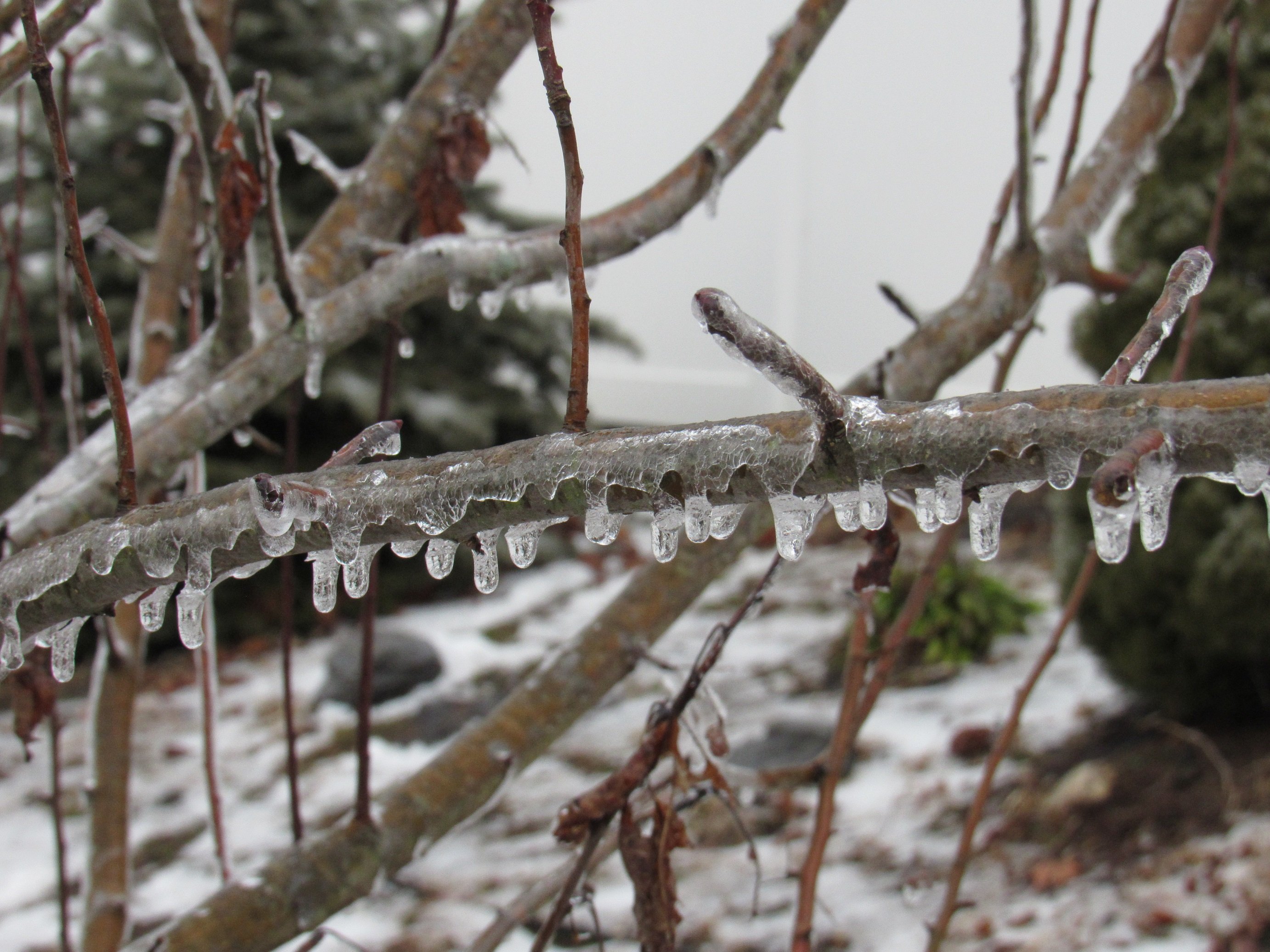
Driveway and sidewalk (concrete) are frozen, but roads in my neighborhood (asphalt) look mostly ok. I'm not going out to drive though. Ice is starting to build up on some of my trees and bushes. Temp is 32. -
Southern MD / Lower Eastern Shore weather discussion
AnEndlessMaze replied to AnEndlessMaze's topic in Mid Atlantic
Today could possibly be an overperformer for some of us I think. I know its far out but... you guys have any thoughts on the stuff later this week? -
BWI finished February at 25.3 degrees, making it the 2nd coldest February ever and 5th coldest month ever (top 10 coldest months are listed below): Jan. 1977 - 22.9 degrees Jan. 1918 - 24.2 degrees Feb. 1934 - 24.3 degrees Jan. 1893 - 24.3 degrees Feb. 2015 - 25.3 degrees Dec. 1989 -25.4 degrees Jan. 1982 - 25.5 degrees Feb. 1979 - 25.6 degrees Jan. 1912 - 25.8 degrees Jan. 1940 - 26 degrees This was also the 2nd coldest Jan-Feb period ever for BWI at a combined average of 28.1 degrees (the first was 1904 at 28.0 degrees). May be too soon but... could BWI try making a run for top 10 coldest year again this year? Edit: I forgot about Dec. 1989 so its been put in the list. I hadn't even bothered checking Dec. cause I figured it couldn't even compete. Wow...