

weathermedic
-
Posts
1,871 -
Joined
-
Last visited
Content Type
Profiles
Blogs
Forums
American Weather
Media Demo
Store
Gallery
Posts posted by weathermedic
-
-
95/65 wind still westerly here.
-
91/65 on a northerly breeze. High so far was 92. Waiting for the sea breeze.
-
Down to 84 here in Sheepshead Bay now with the sea breeze after a high of 95 at 1pm.
-
Just spiked up to 96. My high for the day.
-
26 minutes ago, weathermedic said:
Wind flipped to the north and my temp jumped up to 93.
Wind veered to the east and temp now down to 88. Holding at .40 inches of rain for the month at my station in southern Brooklyn.
-
Wind flipped to the north and my temp jumped up to 93.
-
 1
1
-
-
Reports of ping pong ball size hail in Hicksville via OKX mesonet local storm report automated Twitter feed.
-
Looks like a hook on radar northeast of Hempstead and southwest of the radar indicated hail core.
-
2
-
-
6 minutes ago, weathermedic said:
Cell popped in northern NJ and is in the vicinity of West Orange moving northeast
Severe warned now.
-
Cell popped in northern NJ and is in the vicinity of West Orange moving northeast
-
89/78 at my station.
-
1 hour ago, wthrmn654 said:
NYZ072>075-176-178-211015-
/O.EXT.KOKX.HT.Y.0002.000000T0000Z-220725T0000Z/
New York (Manhattan)-Bronx-Richmond (Staten Island)-
Kings (Brooklyn)-Northern Queens-Southern Queens-
316 PM EDT Wed Jul 20 2022

...HEAT ADVISORY NOW IN EFFECT UNTIL 8 PM EDT SUNDAY...
URGENT - WEATHER MESSAGE
National Weather Service New York NY
316 PM EDT Wed Jul 20 2022

NJZ107-108-211015-
/O.EXT.KOKX.HT.Y.0002.000000T0000Z-220725T0000Z/
Western Union-Eastern Union-
316 PM EDT Wed Jul 20 2022

...HEAT ADVISORY NOW IN EFFECT UNTIL 8 PM EDT SUNDAY...
Don’t ever remember a heat advisory being issued for so many consecutive days.
-
JFK up to 90 on the 10am obs with a westerly wind. EWR also at 90. LAG-87 and of course the park is only at 85.
-
9 hours ago, TriPol said:
Did that bust our drought?
I only received .20 yesterday.....so not everywhere cashed in.
-
Tornado warning for central Baltimore County in MD
-
81/77 zero rain so far today at my station.
-
6 minutes ago, dWave said:
I hearing reports of flooding uptown too. There was flooding from the early morning storms already before this round. I-95 from north of Newark to CT been getting it today. Meanwhile haven't seen a drop in Lower Manhattan.
Yday I was marveling at how dry and brown it was looking.
NYC DOT traffic cam on the Major Deegan Expy at 179 St showing a vehicle stuck in high water under the overpass. NYPD ESU on scene making the rescue. https://webcams.nyctmc.org/google_popup.php?cid=1203
-
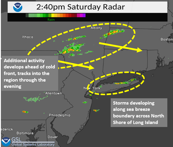
Looks like storms forming along the sea breeze front across Long Island
-
82/73 at my station in Sheepshead Bay
-
From NWS OKX Twitter feed:
-
Basically from central Nassau through most of Suffolk and from the LI Expy and northward.
-
Cell developed over Staten Island and moving east. Another cell over central NJ. Northeast Suffolk County getting hit pretty good.
-
1
-
-
Up to 88/75 now.
-
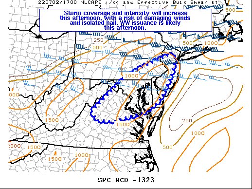
Mesoscale Discussion 1323
   NWS Storm Prediction Center Norman OK
   1216 PM CDT Sat Jul 02 2022

   Areas affected...Parts of Northern VA...Eastern WV
   Panhandle...MD...DC...DE...NJ...Southeast PA

   Concerning...Severe potential...Severe Thunderstorm Watch likely

   Valid 021716Z - 021915Z

   Probability of Watch Issuance...80 percent

   SUMMARY...An increase in storm coverage and intensity is expected
   this afternoon, with an attendant risk of locally damaging wind
   gusts and isolated hail. Severe Thunderstorm Watch issuance is
   likely.

   DISCUSSION...Strong heating is underway across much of the Mid
   Atlantic early this afternoon, though cirrus emanating from
   convection over WV is limiting insolation across parts of northern
   VA. Convection is gradually increasing south of the cirrus shield
   across western VA, while cumulus is gradually increasing across
   southeast PA, to the north of the VA cirrus shield and south of
   another cirrus shield across central/eastern PA. Continued
   destabilization (MLCAPE increasing to near or above 2000 J/kg) will
   support scattered thunderstorm development later this afternoon,
   though local minima in storm coverage will be possible where
   persistent cirrus limits diurnal heating.

   This region is on the southern fringe of stronger midlevel flow
   associated with the deep mid/upper-level trough across eastern
   Canada. Effective shear of 30-40 kt across southeast PA into
   southern NJ will support the potential for a couple of organized
   clusters and/or marginal supercells, capable of locally damaging
   wind gusts and hail. Shear will be somewhat weaker into parts of
   MD/VA/DE, but still sufficient for a few multicell clusters capable
   of locally damaging wind gusts (especially where stronger heating
   occurs), and perhaps some isolated hail.

   Once a definitive uptick in storm coverage/intensity appears
   imminent, Severe Thunderstorm Watch issuance is likely across
   portions of the MCD area.
July 2022
in New York City Metro
Posted
88/67 with the westerly breeze here.