

weathermedic
-
Posts
1,874 -
Joined
-
Last visited
Content Type
Profiles
Blogs
Forums
American Weather
Media Demo
Store
Gallery
Posts posted by weathermedic
-
-
Flurries or what appears to be more like graupel falling in extreme SW Nassau County in Inwood just east of JFK.
-
OKX AFD has it summed up good (at least I think so) as of their 4:48pm update:
All attention is then turned to the approaching low pressure system. This low will form along a frontal boundary over the southeastern CONUS late tonight as a shortwave trough digs through the Southern Plains. It will then track northeastward and pass just to our south and east. 12z guidance has continued to show the area now being on the far northern edge of the precipitation shield. This is a similar solution to what the GFS has been showing for the past several days. Given the cold air that will work into the area overnight tonight, and the low being far enough to our south and east, any precip that does fall over the area will be in the form of snow. Uncertainty still remains, especially given some dry air that needs to be overcome in the midlevels. This will overall be a minor light snow event. Snowfall totals are expected to be greatest over eastern Long Island, where 1-2 inches are possible. Farther west over northeastern NJ and NYC up to an inch is possible. Snow totals drop off farther north, with the CT coast and southern portions of the Lower Hudson Valley likely seeing less than an inch and far northern locations staying dry. Trends in track will need to be monitored given the nature of the tight gradient in QPF and snowfall. Timing of the event may be the biggest concern. Snow starts in the early morning hours on Monday and will continue through the evening. This could impact the morning commute and potentially the evening commute for eastern Long Island. With temperatures dropping quickly overnight tonight to below freezing, snow is expected to stick right away. Given the uncertainty that surrounds this system, and current light snowfall totals, have decided to hold off on any headlines over our area in collaboration with neighboring offices. Subsequent shifts will have to monitor new guidance and a Winter Weather Advisory may be possible for eastern Long Island. The area will likely be completely dry after 7PM and high pressure will build in behind the departing low. Skies clear quickly from west to east in the late evening and a cold night is expected. Winds will also be decreasing overnight as the pressure gradient relaxes, so there may be several hours of good radiational cooling conditions. This will be the case especially if any areas have a fresh snow cover. Lows Monday night are currently forecast to be in the low teens across the interior and the LI Pine Barrens, mid teens to low 20s elsewhere.-
 1
1
-
-
JFK broke their record high temp for the day with 59 degrees. Old record was 57. They could have a couple of inches of snow on the ground by this time tomorrow.
-
1
-
-
1 hour ago, bluewave said:
Almost like a cold season version of what happened with the extreme heat in the PACNW last summer.
And that's with only 6.5 hours of sun:
Dec 27, 2021 9:54 AM -- 4:26 PM 6 hours and 32 minutes -
1
-
-
65 at my station now. Impressive even with the southerly wind off the water.
-
1
-
-
I don’t ever recall seeing a special weather statement with those speeds
-
Showers moving at 100 mph! Is that a typo?

At 1017 PM EST, Doppler radar was tracking showers along a
broken line extending from Clark to Middle Island to near Guilford.
Movement was east at 100 mph.
-
1
-
 1
1
-
-
13 minutes ago, White Gorilla said:
Pretty out of the ordinary isn't it?
Becoming more ordinary as the years go on.
-
It's December but...
Special Weather Statement National Weather Service New York NY 746 PM EST Thu Dec 2 2021 CTZ005-NJZ002-NYZ067>070-030145- Northern Fairfield CT-Western Passaic NJ-Putnam NY-Rockland NY- Northern Westchester NY-Orange NY- 746 PM EST Thu Dec 2 2021 ...Strong thunderstorms will impact portions of north central Fairfield, western Passaic, northern Westchester, Orange, Putnam and Rockland Counties through 845 PM EST... At 745 PM EST, Doppler radar was tracking strong thunderstorms along a line extending from Greentown to near Philmont. Movement was east at 50 mph. HAZARD...Winds in excess of 40 mph and pea size hail. SOURCE...Radar indicated. IMPACT...Gusty winds could knock down tree limbs and blow around unsecured objects. Minor damage to outdoor objects is possible. Locations impacted include... Newburgh, Middletown, West Milford, Peekskill, Ringwood, Mahopac, Monroe, Lake Carmel, Walden, West Point, Warwick, Goshen, Sherman, Sloatsburg and Cold Spring.-
2
-
-
Had what appeared to be graupel falling while on the Verrazano Bridge around 2:15pm.
-
BULLETIN - EAS ACTIVATION REQUESTED Tornado Warning National Weather Service New York NY 253 PM EST Sat Nov 13 2021 The National Weather Service in Upton NY has issued a * Tornado Warning for... West central Suffolk County in southeastern New York... East central Nassau County in southeastern New York... * Until 330 PM EST. * At 252 PM EST, a severe thunderstorm capable of producing a tornado was located over Levittown, moving northeast at 35 mph. HAZARD...Tornado and quarter size hail. SOURCE...Radar indicated rotation. IMPACT...Flying debris will be dangerous to those caught without shelter. Mobile homes will be damaged or destroyed. Damage to roofs, windows, and vehicles will occur. Tree damage is likely. * This dangerous storm will be near... Farmingdale around 300 PM EST. Plainview and Melville around 305 PM EST. Huntington Station and Deer Park around 310 PM EST. Huntington and Dix Hills around 315 PM EST. Commack and Centerport around 320 PM EST. PRECAUTIONARY/PREPAREDNESS ACTIONS... TAKE COVER NOW! Move to a basement or an interior room on the lowest floor of a sturdy building. Avoid windows. If you are outdoors, in a mobile home, or in a vehicle, move to the closest substantial shelter and protect yourself from flying debris. && LAT...LON 4066 7356 4071 7361 4092 7337 4080 7323 TIME...MOT...LOC 1952Z 231DEG 31KT 4072 7355 TORNADO...RADAR INDICATED MAX HAIL SIZE...1.00 IN-
3
-
-
Very windy here now. Gust up to 39 so far here.
-
Had heavy rain (.29) with very little pea sized hail at my station in Sheepshead Bay.
-
2
-
-
-
OKX AFD updated at 1pm:
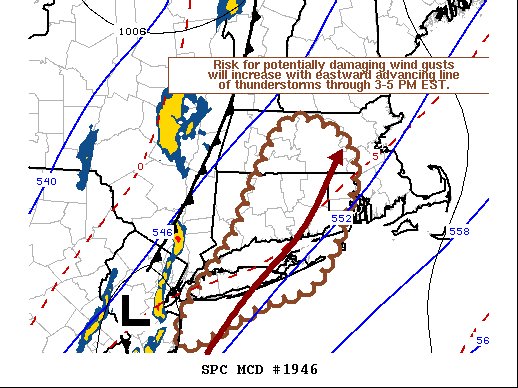
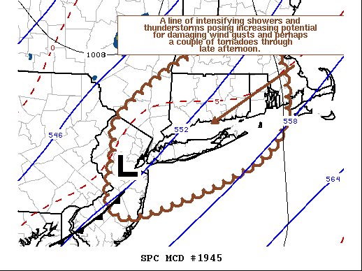
.NEAR TERM /UNTIL 6 PM THIS EVENING/...
Forecast continues on track, except for the NYC area where bkn
mid and high level clouds ahead of the approaching front were
already starting to move in, skies were mostly sunny. Temps had
reached 60 in/around NYC, but dewpoints were still mostly on
the low side, still in the 40s, while lower 50s dewpoints were
draped across Long Island and southern NJ. This higher dewpoint
air should advect northward into this afternoon and help provide
instability for shower/tstms this afternoon. Disorganized line
already forming across the NW NJ/E PA border where there was a
lightning strike earlier. CAM's insistent on development of a
convective line along the approaching cold front over Orange
County southward into NJ between 17Z-18Z and sweeping E this
afternoon, with only minor differences in timing, moving across
NYC and the rest of the Hudson Valley between 18Z-20Z, SW CT
and western Long Island 19Z-21Z, and SE CT/eastern Long Island
20Z-22Z. Fcst soundings show a low CAPE, high shear environment,
with steep lapse rates due to sfc temps in the 50s to lower 60s
and H5 temps as cold as -25C, also strong low level winds
veering from SE to S over the lowest 1 km, with 1 km AGL winds
35-40 kt, and a push of boundary layer winds 40-45 kt right
behind the line. Latest HRRR/NAM-3km have shifted the focus of
potential severe wx a little farther south, so not only agree
with SPC slight risk for most of CT, but think this risk will
also encompass most of the CWA, except perhaps Orange and W
Passaic. So all modes of svr wx are on the table, primarily
wind, but marginally svr hail is also a risk given very cold H5
temps, and cannot totally rule out an isolated tornado given
veering wind profiles with height, but think this risk is lowest
of the three modes since 0-3km CAPE may be limited. Storms will
be fast movers, so the heaviest rain producers will only have
time to drop 1/4 to 1/2 inch at most.
-
Severe t-storm warnings with those cells in western NJ for hail up to .75 inches and winds up to 60mph.
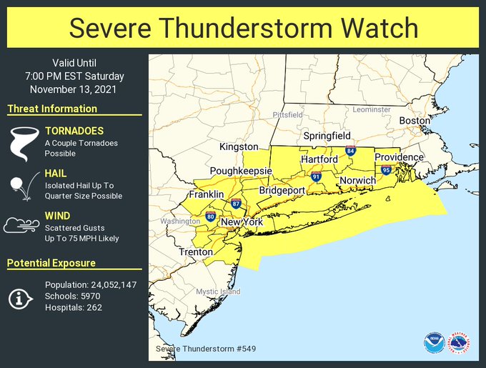
Watch just issued for most of the area:
-
 1
1
-
-
-
-
-
OKX just put this out:
Special Weather Statement
National Weather Service New York NY
1126 AM EST Sat Nov 13 2021

CTZ005>012-NJZ002-004-006-103>108-NYZ067>075-078>081-176>179-
132200-
Northern Fairfield-Northern New Haven-Northern Middlesex-
Northern New London-Southern Fairfield-Southern New Haven-
Southern Middlesex-Southern New London-Western Passaic-
Eastern Passaic-Hudson-Western Bergen-Eastern Bergen-
Western Essex-Eastern Essex-Western Union-Eastern Union-Orange-
Putnam-Rockland-Northern Westchester-Southern Westchester-
New York (Manhattan)-Bronx-Richmond (Staten Island)-
Kings (Brooklyn)-Northwest Suffolk-Northeast Suffolk-
Southwest Suffolk-Southeast Suffolk-Northern Queens-
Northern Nassau-Southern Queens-Southern Nassau-
1126 AM EST Sat Nov 13 2021

...LINE OF SHOWERS AND THUNDERSTORMS WITH GUSTY WINDS AND HAIL
EXPECTED THIS AFTERNOON...

* A cold front moving across this afternoon will be accompanied
  by a line of showers and thunderstorms. This line should develop
  over western portions of New Jersey and the lower Hudson Valley
  after midday and sweep across the rest of the area this
  afternoon, moving across northeastern New Jersey and the rest of
  the lower Hudson Valley before 2 PM. New York City and vicinity
  between 1 to 3 PM. Southwestern Connecticut and Western Long
  Island from 2 to 4 PM. Southeastern Connecticut and eastern Long
  Island from 3 to 5 PM.

* Wind gusts of 40 to 50 mph, brief heavy rain of one quarter to
  one half inch, and small hail are possible as this line moves
  through. The strongest thunderstorms could produce damaging wind
  gusts over 60 mph and hail close to 1 inch in diameter. Some
  downed trees, limbs, and power lines may occur.

* Severe thunderstorm watches and warnings may be a possibility
  for this afternoon as the situation unfolds. Keep an eye to the
  sky and listen to NOAA All Hazards Weather Radio and broadcast
  media for further details.
-
1
-
-
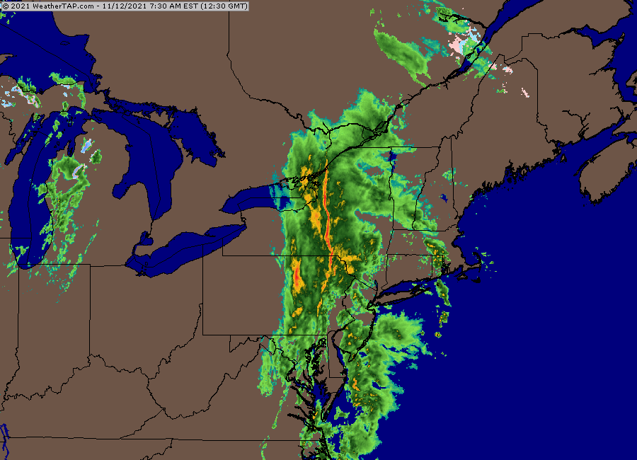
Nice squall line across upstate NY and trying to form in Pennsylvania as well.
-
1
-
-
PUBLIC INFORMATION STATEMENT
NATIONAL WEATHER SERVICE NEW YORK NY
646 AM EDT SUN OCT 31 2021

...CENTRAL PARK NEW YORK WEATHER OBSERVING STATION EARNS
INTERNATIONAL HONOR FOR CENTURY OF WEATHER OBSERVATIONS...

IN RECOGNITION OF ITS LONG TERM AND QUALITY CONTROLLED
METEOROLOGICAL OBSERVATIONS, THE NATIONAL WEATHER SERVICE
OBSERVING STATION LOCATED IN CENTRAL PARK, NEW YORK CITY, HAS
BEEN RECOGNIZED AS A CENTENNIAL OBSERVING STATION BY THE WORLD
METEOROLOGICAL ORGANIZATION (WMO). OBSERVATIONS HAVE BEEN
COLLECTED AT THIS LOCATION SINCE 1868, OVER 150 YEARS.

THE MORE THAN A CENTURY-LONG ACCUMULATION OF DAILY WEATHER
OBSERVATIONS TAKEN AT THE CENTRAL PARK SITE IS THE CLIMATE RECORD
STANDARD FOR THE CITY. FROM THE BLIZZARD OF 1888 TO THE REMNANTS
OF IDA, THE STATION HAS MEASURED THE METEOROLOGICAL EXTREMES OF
THE MOST NOTORIOUS OF WEATHER EVENTS IN NEW YORK CITY HISTORY. THE
WEATHER MEASUREMENTS COLLECTED AT THE CENTRAL PARK STATION
INCLUDE, TEMPERATURE, PRECIPITATION, BAROMETRIC PRESSURE,
HUMIDITY, WIND SPEED AND DIRECTION, VISIBILITY AND CEILING
HEIGHT.

"THE NATIONAL WEATHER SERVICE RELIES ON THE WEATHER STATION IN
CENTRAL PARK, NY FOR CURRENT SURFACE OBSERVATIONS NEEDED FOR
WEATHER FORECASTING, AND ITS LONG PERIOD OF RECORD IS A VALUABLE
RESOURCE FOR MEASURING CLIMATE VARIABILITY," SAID LOUIS W.
UCCELLINI, PH.D, DIRECTOR, NATIONAL WEATHER SERVICE AND THE
UNITED STATES PERMANENT REPRESENTATIVE FOR WMO.

IT IS RARE TO HAVE A WEATHER OBSERVATION SITE REMAIN ON THE SAME
LAND FOR OVER 100 YEARS, ESPECIALLY IN A MAJOR CITY. CENTRAL PARK
IS ONE OF ONLY EIGHT STATIONS IN THE COUNTRY, 234 IN THE WORLD,
TO BE NAMED A CENTENNIAL OBSERVING STATION. OFFICIAL WEATHER
OBSERVATIONS BEGAN IN NEW YORK CITY IN 1868, WHEN AN AGREEMENT
WAS MADE BETWEEN THE CENTRAL PARK BOARD OF COMMISSIONERS AND NEW
YORK STATE TO TAKE AND RECORD METEOROLOGICAL OBSERVATIONS. A FEW
YEARS LATER, ADDITIONAL WEATHER OBSERVATIONS BEGAN IN THE LOWER
PARTS OF MANHATTAN BY A FLEDGLING NATIONAL WEATHER SERVICE,
ORIGINALLY THE US SIGNAL SERVICE. ON JANUARY 1, 1920, THE NATIONAL
WEATHER BUREAU TOOK OVER THE WEATHER OBSERVATIONS IN CENTRAL
PARK, OFFICIALLY AT THE BELVEDERE CASTLE. ALTHOUGH THE WEATHER
INSTRUMENTATION HAS CHANGED A BIT OVER THE YEARS, THE LOCATION IS
PRECISELY THE SAME.

"THESE ARE THE TYPES OF STATIONS, THE RELATIVE FEW, THAT GARNER
THE MOST INTEREST AND RIGHTFULLY CLAIM THE HIGHEST VALUE," SAID
TIM MORRIN, OBSERVATION PROGRAM LEADER, NATIONAL WEATHER SERVICE
NEW YORK WEATHER FORECAST OFFICE. "IT WOULD BE VERY DIFFICULT FOR
US TO FULFILL THE MISSION OF SAVING LIVES AND PROPERTY WITHOUT THE
HELP OF THE DEDICATED INDIVIDUALS AND INSTITUTIONS COLLECTING AND
ARCHIVING THESE IMPORTANT OBSERVATIONS FOR THE NATIONAL WEATHER
SERVICE."

A VIRTUAL AWARD CEREMONY TO HONOR CENTRAL PARK AS A CENTENNIAL
STATION WILL BE HELD AT 11 A.M. ON NOVEMBER 3RD. FOR MORE
INFORMATION PLEASE CONTACT...TIM MORRIN, [email protected]

THE NATIONAL WEATHER SERVICE NEW YORK FORECAST OFFICE, LOCATED IN
UPTON N.Y., IS THE PRIMARY SOURCE OF WEATHER DATA, FORECASTS AND
WARNINGS FOR ABOUT 19 MILLION PEOPLE IN NORTHEASTERN NEW JERSEY
(5 COUNTIES), SOUTHEASTERN NEW YORK (11 COUNTIES), AND SOUTHERN
CONNECTICUT (4 COUNTIES).
-
 1
1
-
-
3.82 at my station here in Sheepshead Bay.
-
Up to 3.06 inches at my station so far. Still not much wind to speak of.
January 2022
in New York City Metro
Posted
Freezing rain/drizzle over much of the area. Even in the city with temps of 33-34, some of the bridges and overpasses are beginning to get slippery. Especially Staten Island crossings.