

CNY_WX
-
Posts
2,717 -
Joined
-
Last visited
Content Type
Profiles
Blogs
Forums
American Weather
Media Demo
Store
Gallery
Posts posted by CNY_WX
-
-
2 minutes ago, lakeeffectkid383 said:
Well to my north but beautiful looking band right over KBUF for the last hour or so.

Things look pretty nasty at Elmwood Ave!
-
40 minutes ago, Buffalo Bumble said:
January 2022's weather journal for Buffalo written circa 1691...
* Every day this month (26 days!) has had measurable snow. I fear this climate is too harsh for any long-term settlement as these conditions are akin to those rumored to occur in the far northern regions.
* The snow appears suddenly out of nowhere. Our local Doctor/Pastor/Postmaster/Weatherman announced today that the snow streak would be broken as the atmospheric pressure was certainly too high for any frozen precipitation to fall. No sooner said than 2 inches of fluff fell from the sky this morning. And lo...as I pen this there are yet more cotton balls pouring down into the night. Clearly weather forecasting has a long way to go...I'm sure by the 21st century such folly will never take place.
* The heavy falls of snow are unlike anything even written in legend. Two separate days in a little over a 1 week span where 17 inches fell!
* Remarkably, we have a report from our fellow settler Tughillory Matt of the Lysander colony of no snow cover, mild temperatures, and even early blooming plants. Given his proximate latitude to our colony he must be located in a wonderful microclimate to afford such mid-winter bliss. Oddly, all of his correspondence gives a sad and bitter tone.
So that's my silly way of relaying some pretty amazing stats for BUF in January (20)22!
I believe the Lysander colony is possessed of a spirit from the underworld who brings sizzle to the colony and environs. A witch hunt may be in order.
-
 1
1
-
 4
4
-
-
8 minutes ago, Syrmax said:
Close to same here. I'll say one thing, this Jan has delivered the cold.
January should be the first month with a negative temperature departure in quite a while.
-
1
-
-
-3 here already. I got down to -10 this morning.
-
50 minutes ago, brentrich said:

Why didn’t you pick this time period.

-
5
-
-
26 minutes ago, Ericjcrash said:
They’ve been NAMed.
-
1
-
-
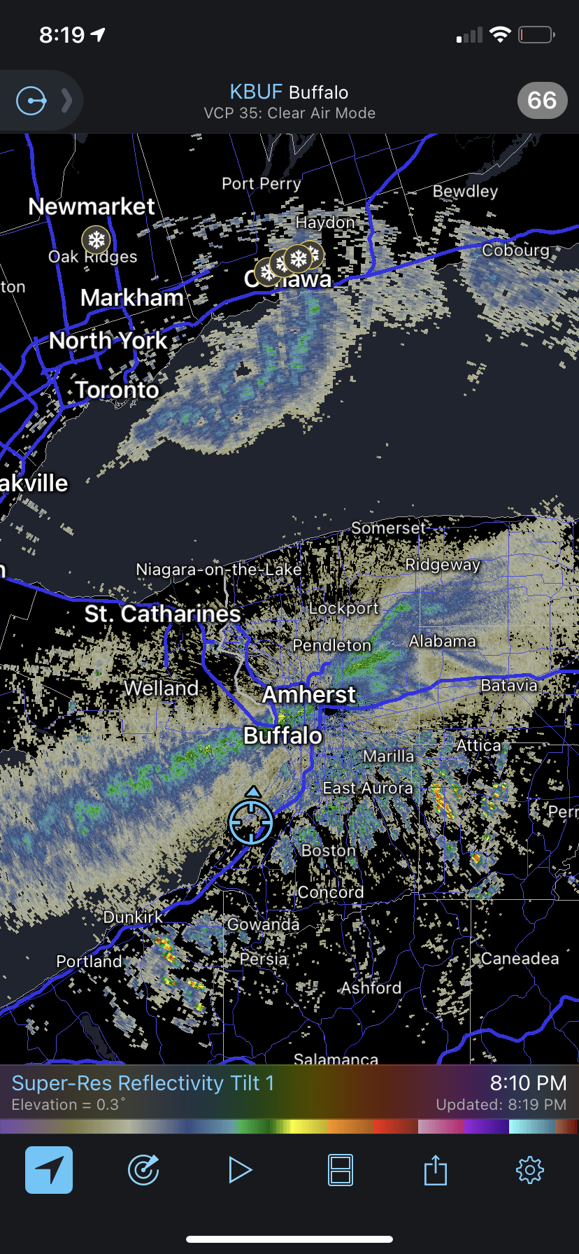
11 minutes ago, SouthBuffaloSteve said:
 this Lake Ontario band has been incredible to watch. Looks like it’s going to spin up into a bigger more defined swirl as it gets pushed north
Heading towards Toronto? It looks like the band over the lake could be over the GTA right around rush hour.
-
5 minutes ago, wolfie09 said:
Powerful CF . KSyr drops 30° in 6 hours.. Granted it's 200 hours out lol


Unfortunately most of the precipitation is on the warm side.
-
1
-
-
Just now, TugHillMatt said:
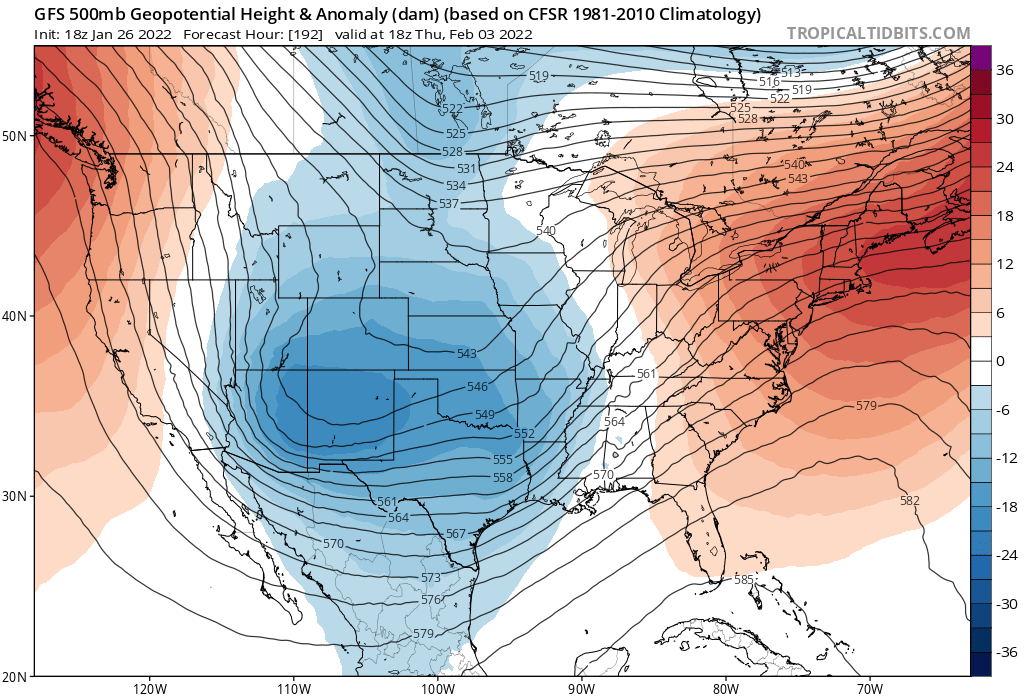
Yikes, looks pretty boring through the end of next week. Hopefully the lake effect keeps providing.
Looks like the GFS wants to wind up the storm at the end of next week and wipe out our snow cover with rain and mild temperatures. Then the next wave passes over us and gives us mixed precipitation.
-
I’ve always said that when we get screwed by synoptic systems we find a way to make it up with lake effect. Almost 8 inches here over the last 3 days.
-
3
-
-
3 minutes ago, rochesterdave said:
My mojo. COME TO DADDY
I was going to blame it on Tim and his snow magnet but he lives east of there.
-

What is causing that band to bend into Rochester? -
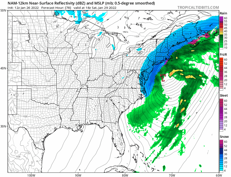
12 minutes ago, BuffaloWeather said:
I can almost guarantee the low pressure system will not do this track. Nam is such a trash model lol
81 vs 84 hour it goes back SW and strengthens, not happening


You can see what happens between 81 and 84 hours. At 81 hours there are 2 low centers, one southwest of the center marked with the L. At 84 hours the 2 centers consolidate and the resultant center is slightly south of the 81 hour center.
-
1
-
 1
1
-
-
35 minutes ago, Syrmax said:
If i read that radar map right I'm virtually due west of you. Maybe a touch south of due west.
Snowing pretty hard.
I think that was the last heavy cell to move through here. There were a couple upstream that looked promising but they fell apart. I don’t think I’m that far from you but I have just enough additional latitude to get me into some of these bands while you get flurries.
-
1
-
-
27 minutes ago, wolfie09 said:
We'll get em in 12 days..
.thumb.png.6aff31a20efb222bac9b339d82c56c66.png)
I’m holding my breath.
-
2
-
-
Riding right along the southern edge of this band. I’m in and out of some heavy snow showers. This one that’s about to hit should be interesting.

-
1
-
 1
1
-
-
2 minutes ago, sferic said:
4 miles more south please
You should be catching the southern edge of the cell I’m in for at least a little while.
-
1
-
-
11 minutes ago, Revracer800 said:
Those heavier burst keep coming through here every 10 minutes lol. Whiteout to nothing, whiteout to nothing lol.
It is really snowing here again. Radar shows multiple embedded heavy cells with breaks in between.
-
2
-
-
3 minutes ago, TugHillMatt said:
Based on the radar this afternoon, Syracuse and just SOUTH of the Thruway has been doing better with snowfall than the North Syracuse
 zone.
zone.
Most of the snow has moved north. What a crazy setup. I had about an hour this morning when conditions looked really good. Then the band fell apart and the good action moved south. Now there is a few heavier cells but nothing organized.
-
1
-
-
3 minutes ago, Revracer800 said:
Didn't notice lol. It's dumping like crazy here right now. Complete whiteout.

I see what’s over you. You have a couple more waves behind this.
-
1
-
-
2 minutes ago, Syrmax said:
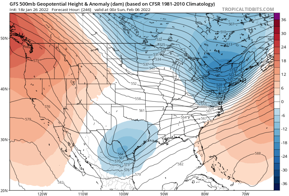
Classic setup for them, slp over the BM or a smidge outside it. I have friends in SE CT so a chase visit is tempting as that area looks to be 16-18" on that GFS map. But, local knowledge, SECT near the coast is a notorious screw hole for max snows. Could see them getting a foot but not chase worthy. Maybe.
My wife is from NE Connecticut. Looks like they could get a foot and a half along with strong winds.
-
1 minute ago, TugHillMatt said:
The band is weakening and did the splits. However, it's snowing heavily here with huge flake size.
I’m hoping to eventually get back into that heavier stuff near Granby.
-
Just now, sferic said:
A few hundred yards off of 31, Two miles east of 81, just mood flakes now
Near South Bay?
-
2 minutes ago, TugHillMatt said:
The band arrived here about 5 minutes ago. Nothing heavy, but a light to moderate snowfall of pea-sized snowflakes.
Flake size is good here. There’s a “notch” in the band that shows pass over me so I see a break coming. But the band seem to be well oriented west of there so I should get back into it.


.png.09e64eac4f1b3b3a666bf4ecdc40e227.png)


Upstate/Eastern New York-Pattern Change Vs Tughill Curse?
in Upstate New York/Pennsylvania
Posted
I love reading the comments on the TheForumThatShallNotBeNamed. Right now there’s never been a better model than the CMC, the GFS should never be trusted and one met even mentioned the JMA since it has consistently shown a big storm for the sub-forum.