

CNY_WX
-
Posts
2,717 -
Joined
-
Last visited
Content Type
Profiles
Blogs
Forums
American Weather
Media Demo
Store
Gallery
Posts posted by CNY_WX
-
-
The temperature of Lake Erie is anomalously warm for this time of year. With very cold 850 temperatures that could produce extremely heavy snowfall rates that could be over the stadium at game time.
-
Sizzlecuse living up to the name.
-
40 minutes ago, BuffaloWeather said:
Just talked to Dan over at BUF NWS and he confirmed no more than 4 wipes per 24 hour period. They are trying to gather data for 24 hour maximum totals. Just gave him all my 6 hour measurements.
Did he say anything about placing the board on top of the snow after each measurement? That seems to be a point of contention to some.
-
I measured 9.6 inches here for yesterday. Got a burst of snow for about an hour in the morning. Then for the afternoon the main band moved about 10 miles north of me. Around 6 PM it moved south and I got about an hour and a half of very heavy snow. The band started weakening but the snow lasted until almost midnight. It’s nothing compared to western New York but about what I was hoping for.
-
 1
1
-
-
8 hours ago, BuffaloWeather said:

Only 3.7 inches at KSYR. KBUF can start planning the victory parade for the golden snowball.
-
Is the golden snowball race over before it even started?
-
2
-
 3
3
-
-
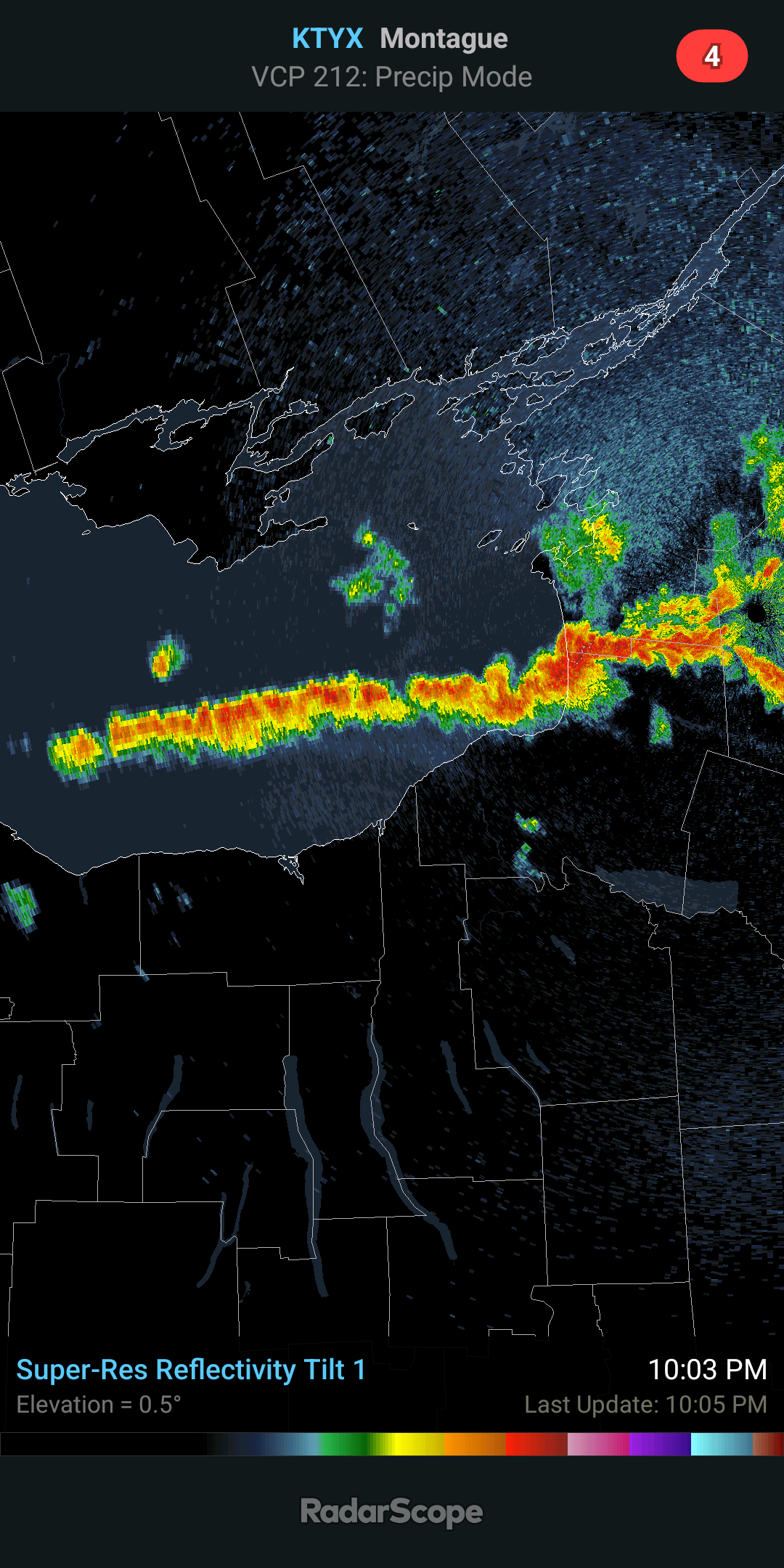
KBUF 190654Z 21014KT 1/8SM +SN BLSN VV002 M03/M04 A3006 RMK AO2 PK WND 22029/0607 SLP187 SNINCR 4/19 P0031 T10331039 RVRNO $
-
1
-
-
4 minutes ago, BuffaloWeather said:
airport getting hit hard!

They reported 4 inches between 1 and 2 AM. 19 inches on the ground.
-
2
-
-
-
31 minutes ago, BuffaloWeather said:
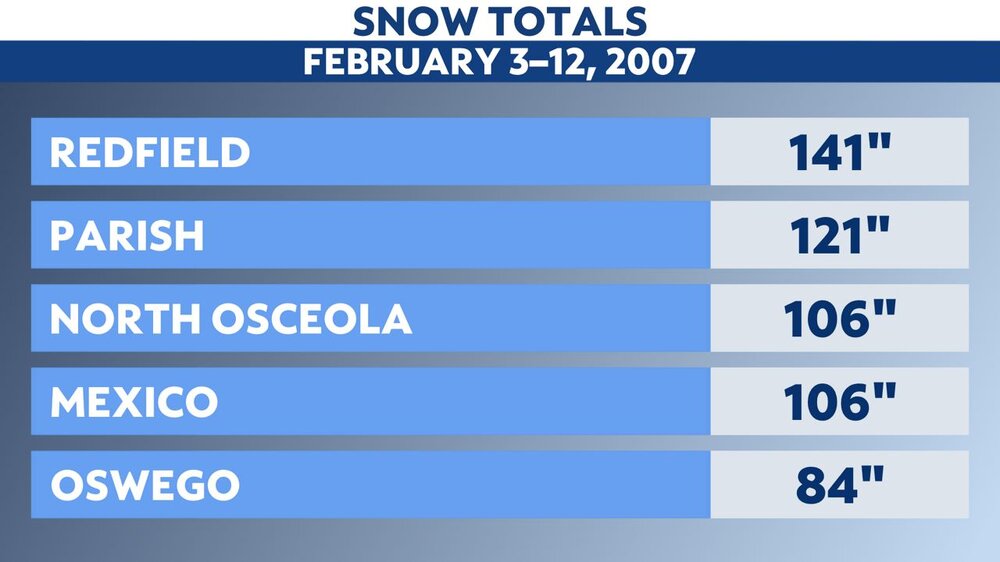
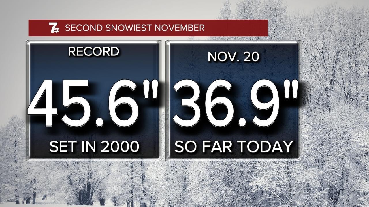
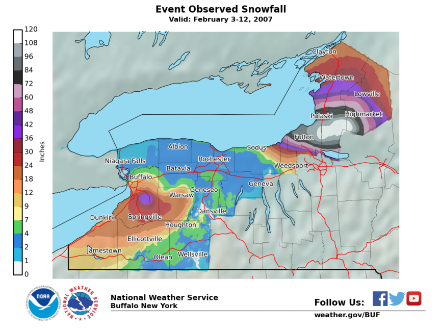
Elma ny had 98” in November 2014, I had 88” here. Buffalo airport record is dec 2001 event at 82”. 2007 is biggest event on record at tug hill 10 day totals of 140”
-
 1
1
-
-
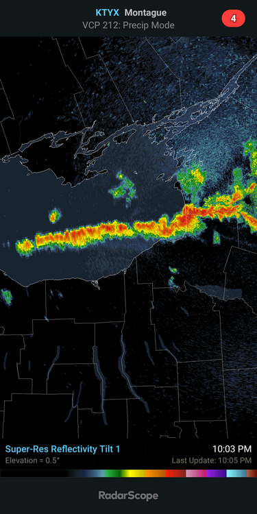
If that band is still sitting over Orchard Park on Sunday what’s the possibility that the game is either called off or played in an empty stadium. There would probably be a travel ban in effect at that time.
-
1 hour ago, BuffaloWeather said:
This looks to be a 3/4 part event. RGEM showing 20" for the southtowns tomorrow night/thursday

This appears to be the time that if we are to get anything meaningful in northern Onondaga/southern Oswego counties it will happen before the band moves north. Not expecting anything blockbusters but it would be nice to at least have a couple of inches on the ground.
-
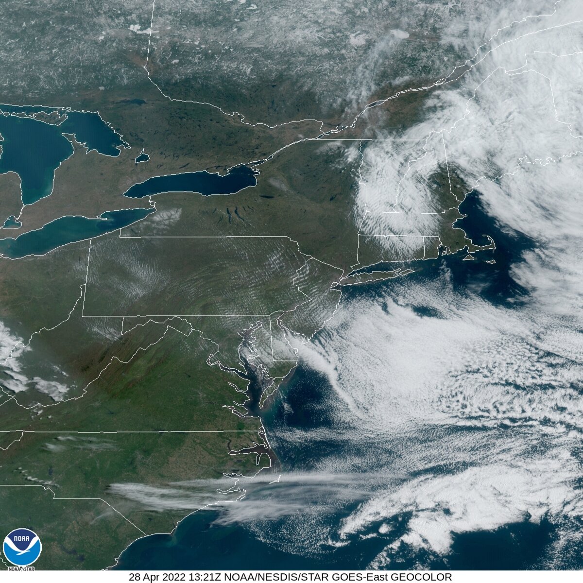
As I mentioned in the other Ian thread, NASA made the correct decision to move the Artemis rocket from the launch pad back to the Vehicle Assembly Building. It looks like the remnants of the north eye wall will pass near or over Cape Canaveral tomorrow.
-
1
-
-
2 minutes ago, Wannabehippie said:
Ivan?
Plus no rocket should get hit with lightning, which is a possibility as well.Sorry, you know I meant Ian.
-
4
-
-
It looks like NASA made the right decision moving the Artemis rocket back to the Vehicle Assembly Building. If Ivan stays on the current course it looks to exit the east coast around Melbourne. That would put Cape Canaveral in the remnants of the north eye wall. I don’t think that rocket was designed to withstand that kind of wind and rain.
-
4
-
-
13 hours ago, wolfie09 said:
Crazy lightning with this..
That line came through here around 11:30 PM with a burst of heavy rain. I’ve measured 4.85 inches of rain in August, most of which fell in the last 10 days. There’s a definite touch of fall in the air on the first day of meteorological fall.
-
1
-
-
After a dry few weeks we had several heavy downpours yesterday that added up to 1.51 inches as of 8 AM. We are currently experiencing an extremely heavy downpour and are probably pushing another inch since 8 AM. Any rainfall deficit for the month is now erased.
-
2
-
-
Goofus says what torch?
-
1
-
-
I was at 82 just after midnight. It made it down to 72 (prob after the thunderstorms, 0.26”). Already back in the mid-upper 80s.
-
1
-
-
11 hours ago, Syrmax said:
I had 1.12" rain yesterday, mainly in afternoon with a garden variety thunderstorm. Severe threat looked to generally not materialize.
There was golf ball sized hail not too far west of us in Victory. I ended up with 0.82 inch of rain but nothing severe. Winds were stronger here this afternoon probably in the 25-30 mph range.
-
1
-
-
Severe Weather Statement National Weather Service Binghamton NY 520 PM EDT Thu Jun 16 2022 NYC011-053-067-099-162145- /O.CON.KBGM.SV.W.0058.000000T0000Z-220616T2145Z/ Seneca NY-Madison NY-Cayuga NY-Onondaga NY- 520 PM EDT Thu Jun 16 2022 ...A SEVERE THUNDERSTORM WARNING REMAINS IN EFFECT UNTIL 545 PM EDT FOR NORTHWESTERN SENECA...NORTHWESTERN MADISON...NORTHWESTERN CAYUGA AND CENTRAL ONONDAGA COUNTIES... At 520 PM EDT, severe thunderstorms were located along a line extending from Cayuga to near Kirkville, moving east at 15 mph. HAZARD...60 mph wind gusts and quarter size hail. SOURCE...Radar indicated. IMPACT...Hail damage to vehicles is expected. Expect wind damage to roofs, siding, and trees. Locations impacted include... Onondaga, Syracuse, Auburn, De Witt, Van Buren, North Syracuse, Seneca Falls, Solvay, Waterloo and Chittenango. PRECAUTIONARY/PREPAREDNESS ACTIONS... A Tornado Watch remains in effect until 1100 PM EDT for central New York. -

This morning’s visible satellite shows the snow that fell over western New York yesterday.
-
3
-
-
2 minutes ago, Syrmax said:
I was up late watching Better Call Saul S6 premiere that I had recorded. By 1 a.m. I turned in and it was still a mix, more R than S it appeared.
I recorded that too, haven’t watched it yet. It didn’t start flipping here until almost 2:30.
-
21 minutes ago, donsutherland1 said:
Elevantion notwithstanding, it was an amazing event. Based on some of last night's radar, the snow fell really heavily at times (probably near 3" per hour in spots).
Last night on Facebook NWS Binghamton reported 3 inches between 1 and 2 AM at KBGM.
-
4
-


Lake Effect Event-Buffalo Bills Playoff Game Impacts
in Upstate New York/Pennsylvania
Posted
Getting to be late in the game, no pun intended, to move the game now.