

tombo82685
-
Posts
13,428 -
Joined
-
Last visited
Content Type
Profiles
Blogs
Forums
American Weather
Media Demo
Store
Gallery
Posts posted by tombo82685
-
-
5 minutes ago, wolfie09 said:
Icon won't let the northern solution go lol

Even further north looks like it goes over syr. Nice qpf blitz with the waa. We take violently. Might get mixing to me in that solution
-
 1
1
-
-
3 minutes ago, Geez150 said:
If I hit the lotto that's where I'd be headed...one can only dream.
I could see UP of mich, but Maine doesn’t avg nearly as much as syr or tuggies
-
7 minutes ago, wolfie09 said:
Well this what the NWS is talking about..I'm surprised warm air doesn't make it farther north TbH, might have something to do with the transfer off the coast..
.thumb.png.85024a8fb2d1c45e12ce6301821155d4.png)
.thumb.png.a3d92c94930b00c46cee7e75cc67d23a.png)
Reason why I’m thinking mix gets to i90. Globals will miss sneaky warm layers as we have seen all winter long. Let’s see what mesos show as we get closer in. Regardless still looks like 4-8” event region wide
-
 1
1
-
-
ggem, looks good, gets mixing to about bgm, bit colder than 12z
-
IMO, think mixing gets up to or close to i90 corridor
-
4 minutes ago, BuffaloWeather said:
For you snow depth weenies. 4-5’ up top

boing
-
1
-
 2
2
-
-
2 minutes ago, rochesterdave said:
I feel like this storm has a lot in common with the early February one. Monster high to the north seems familiar here. Hope so.
yes sir, both overrunning systems. Remember how that came north within like 3 days
-
1
-
-
31 minutes ago, BGM Blizzard said:
Probably right. I'm fully expecting the mix line to get atleast to the Southern Tier for a time... and yeah maybe even a bit north of there. I don't think the ICON solution comes to fruition though. This system looks too weak to get that far north. I think I90 is pretty safe for all snow.
Well strength will be determined by how much energy digs out west. There is no blocking to anchor that high in really so you’re at the mercy of the tpv being close enough to basically be your pseudo block to keep this south
-
3 minutes ago, BGM Blizzard said:
Meanwhile the ICON keeps steaming for Jamestown
Honestly, gfs probably still to far south imo given how gfs has been last to catch up. Ggem and euro have been locked in and get mixing to about cortland area. Icon could be close to final outcome with how these like to bump north inside of 3 days. Still tho k everyone gets a good thump regardless. That’s a beast of a high to the north
-
1
-
-
11 minutes ago, BGM Blizzard said:
12/18z NBM
.thumb.png.1dff7e5ade9aba2063254358b1dff005.png)
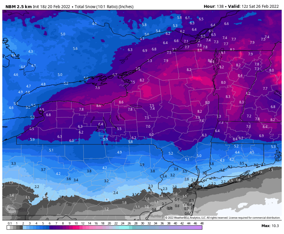
I like that shift
-
3
-
-
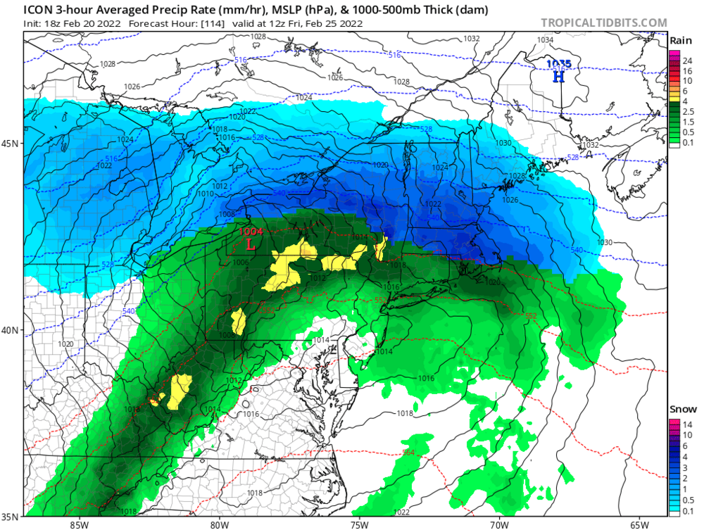
Eps targeting i90 corridor for center of this
-
 1
1
-
-
generally looks like a nice 4-8 on models right now across the area
-
1
-
-
euro looks a bit warmer than 0z, but not a ton of difference. Def a bit wetter down towards bgm. Could be decent thump to ice there
-
1
-
-
Also keep in mind these overrunning systems love to tick north inside 3 days. Remember the one back in early February
-
1
-
-
Seems like gfs is reverting back to its old ways of making everything so progressive in medium range with blasting cold air to the coast. Then to only correct to other models once we get inside 5 days
-
1
-
-
2 minutes ago, tim123 said:
This isn't va or southern pa
March is a winter month down in southern PA too lol. They avg almost as much as December
-
1 minute ago, Thinksnow18 said:
Oddly I’ve always felt March was October, April was September, may was August and June and July were on their own.
Start of March is probably like early October, but once into mid March probably looking like late September sun angle. Regardless, it plays a role in March
-
1
-
-
4 minutes ago, CNY_WX said:
I have to disagree with you. As we get into March the increasing sun angle makes it more and more difficult to accumulate snow during the day, especially on paved surfaces. Once we get past mid month snowfall like we had yesterday will get obliterated by the sun within a day even with temperatures in the 20s.
Agreed, March sun angle is that of September. You can definitely notice the difference big time that snow struggles to accumulate unless it’s snowing at a good clip
-
1
-
-
@wolfie09you see Pulaski coop had a T for yesterday unless all your snow came after 7am yesterday
-
Looks like that’s about it. Go with 8” on the day, not bad
-
4
-
-
What a snow squall, of course I’m in southeast PA lol

-
 1
1
-
-
Crushed. Those trees are like .15 of a mile from my house

-
2
-
1
-
-
Coming down good right now. On the outer fringe of that weenie band. Getting some tentacles off of it
-
1
-
-
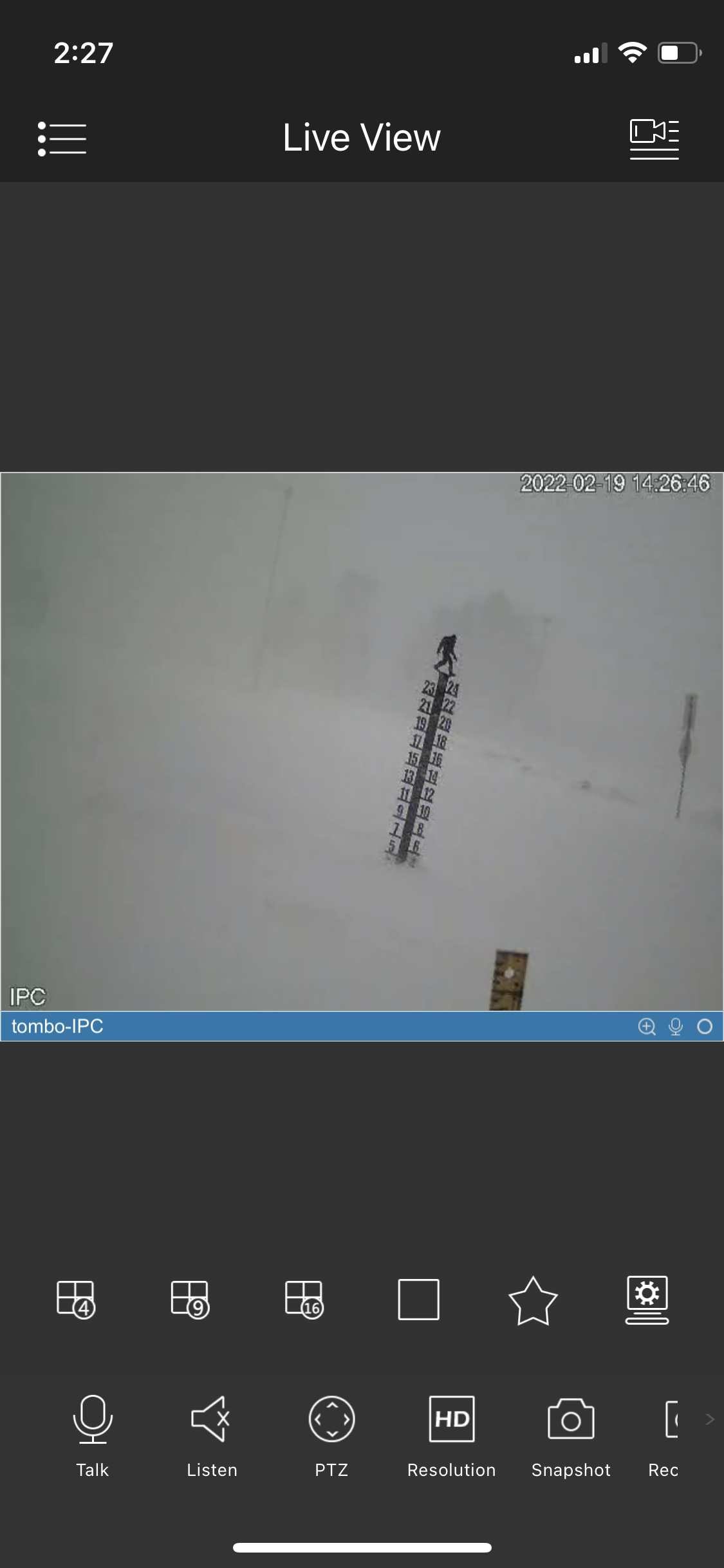
24 minutes ago, wolfie09 said:
All snow is being pushed against the house..

Yea I had 8” on my snow stake before the wind took over. Now it’s impossible to figure how much has fallen
-
2
-
.png.ce5bbb8a615832aed0975a645b737c4a.png)
.png.0cb80c1f59e037e19d6c8fa4f4840ede.png)

.png.37434e04a7650234d880884463624bb3.png)


Potential of Widespread Snow/ Mixed Precipitation 2/25
in Upstate New York/Pennsylvania
Posted
Yea that Sunday afternoon/night period looks interesting with a potent ULL dropping south with arctic blast