donsutherland1
-
Posts
23,765 -
Joined
Content Type
Profiles
Blogs
Forums
American Weather
Media Demo
Store
Gallery
Everything posted by donsutherland1
-
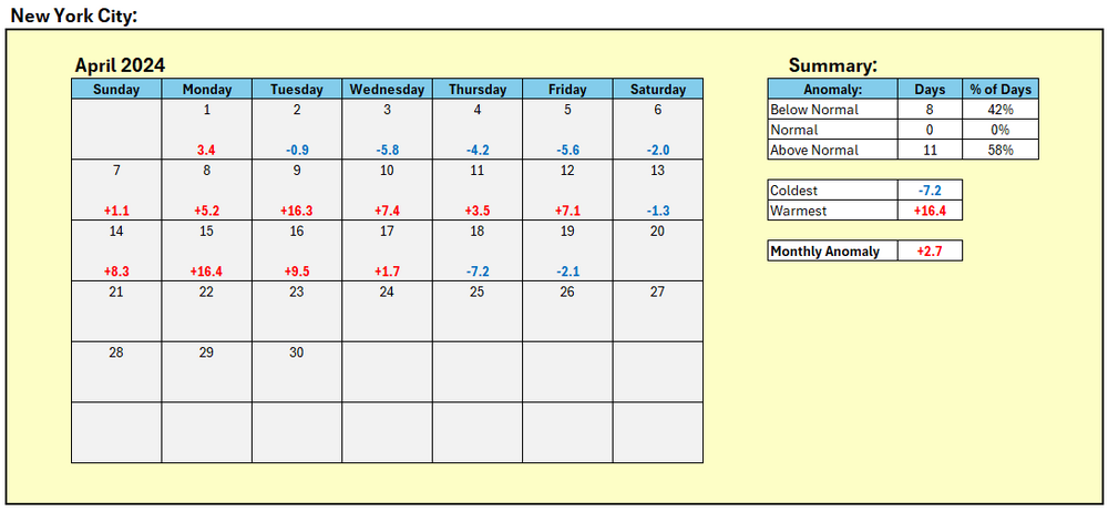
Under mainly cloudy skies, much of the region struggled to reach the low 50s. Tomorrow will be somewhat milder, but generally cooler than normal conditions will likely persist through most of the week. It could turn warmer as April concludes with May starting with warmer to much warmer than normal temperatures. The ENSO Region 1+2 anomaly was -0.2°C and the Region 3.4 anomaly was +0.9°C for the week centered around April 10. For the past six weeks, the ENSO Region 1+2 anomaly has averaged +0.10°C and the ENSO Region 3.4 anomaly has averaged +1.15°C. The ongoing basinwide El Niño event is fading. Neutral conditions could develop later in the spring. The SOI was -4.33 today. The preliminary Arctic Oscillation (AO) was -0.594 today. Based on sensitivity analysis applied to the latest guidance, there is an implied 74% probability that New York City will have a warmer than normal April (1991-2020 normal). April will likely finish with a mean temperature near 54.9° (1.2° above normal).
-
Occasional Thoughts on Climate Change
donsutherland1 replied to donsutherland1's topic in Climate Change
Some actually are on the front lines e.g, NASA’s Peter Kalmus. The news media covers even trivial entertainment and business developments (small scale impact) and devotes very little coverage to climate change and related events. Perhaps an extreme heatwave in Paris that coincided with the summer Olympics would bring worldwide coverage. In the meantime, the fossil fuel industry continues to dump greenhouse gases into the atmosphere, receive trillions of dollars in subsidies, and inflict growing harm on human health/lives and ecosystems. -
Occasional Thoughts on Climate Change
donsutherland1 replied to donsutherland1's topic in Climate Change
Tragically, society tolerates their dishonesty. -
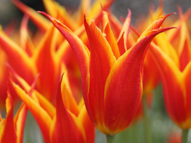
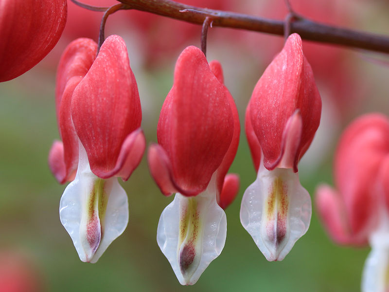
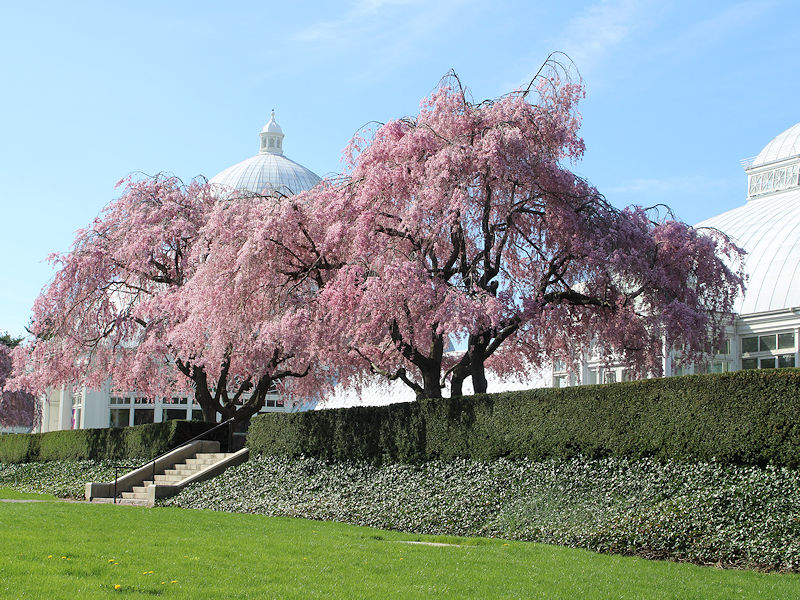
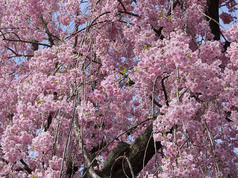
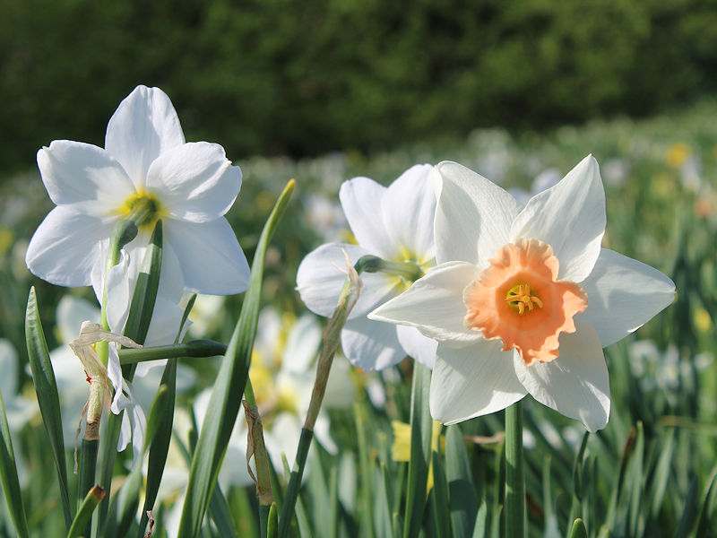
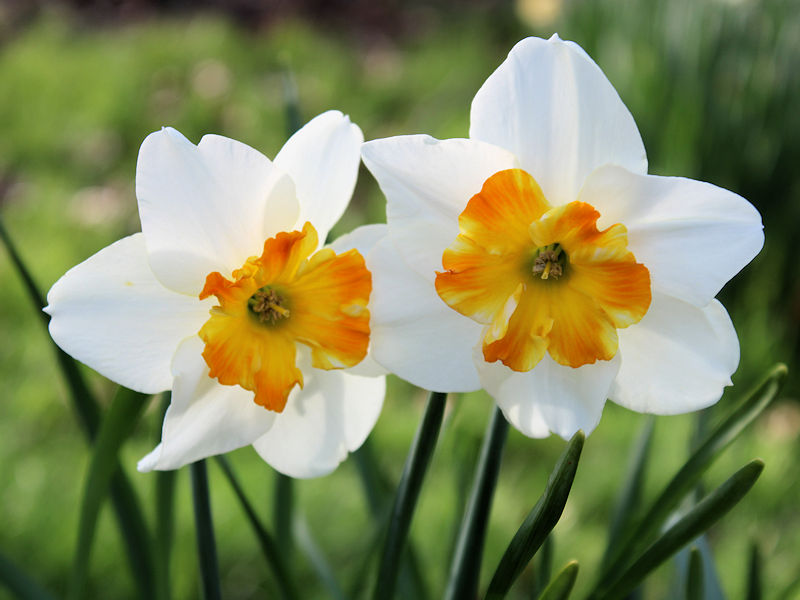
Despite the rapid arrival of clouds, spring is in all its spectacular glory at the New York Botanical Garden.


-
My guess is that we'll see the temperature reach 90 or above at least once during May.
-
The temperature did overperform today. At NYC, it was 2 sigma above the forecast high. However, it does seem that busts more often than not occur when temperatures are higher than forecast. It's tough to know whether on a day-to-day basis, the warming climate is playing a role. But on a weekly or longer scale, the warming climate has contributed to outcomes winding up generally above the modeled forecasts.
-
Sunshine returned this afternoon boosting regional temperatures into the 60s. Some locations, including New York City, Newark, and Philadelphia reached 70° or above. Cooler air is now overspreading the region on a gusty breeze. Generally cooler than normal conditions will likely persist through most of next week. However, the cold won't be exceptional. It could turn warmer as April concludes with May starting with warmer to much warmer than normal temperatures. The ENSO Region 1+2 anomaly was -0.2°C and the Region 3.4 anomaly was +0.9°C for the week centered around April 10. For the past six weeks, the ENSO Region 1+2 anomaly has averaged +0.10°C and the ENSO Region 3.4 anomaly has averaged +1.15°C. The ongoing basinwide El Niño event is fading. Neutral conditions could develop later in the spring. The SOI was +5.33 today. The preliminary Arctic Oscillation (AO) was -0.246 today. On April 14 the MJO was in Phase 4 at an amplitude of 0.520 (RMM). The April 13-adjusted amplitude was 0.553 (RMM). Based on sensitivity analysis applied to the latest guidance, there is an implied 80% probability that New York City will have a warmer than normal April (1991-2020 normal). April will likely finish with a mean temperature near 55.1° (1.4° above normal).
-
I suspect some of the interest can be seen in severe weather discussions and tropical cyclone discussions. Commentary seems to drop off when it comes to heat, probably because a lot of people don't like it. Nevertheless, heat is an important topic for discussion.
-
For NYC:
-
Probably by summer.
-
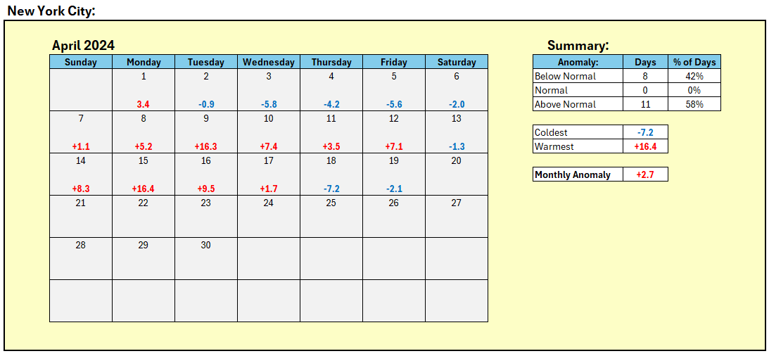
Tomorrow will see temperatures briefly return to near seasonable levels. However, another cold front will likely cross the region with a return to cooler conditions to conclude the weekend. Overall, generally cooler than normal conditions will likely persist through most of next week. However, the cold won't be exceptional. It could turn warmer as April concludes with May starting with warmer to much warmer than normal temperatures. The ENSO Region 1+2 anomaly was -0.2°C and the Region 3.4 anomaly was +0.9°C for the week centered around April 10. For the past six weeks, the ENSO Region 1+2 anomaly has averaged +0.10°C and the ENSO Region 3.4 anomaly has averaged +1.15°C. The ongoing basinwide El Niño event is fading. Neutral conditions could develop later in the spring. The SOI was +12.18 today. The preliminary Arctic Oscillation (AO) was not available today. On April 14 the MJO was in Phase 4 at an amplitude of 0.520 (RMM). The April 13-adjusted amplitude was 0.553 (RMM). Based on sensitivity analysis applied to the latest guidance, there is an implied 74% probability that New York City will have a warmer than normal April (1991-2020 normal). April will likely finish with a mean temperature near 55.0° (1.3° above normal).
-
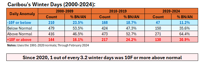
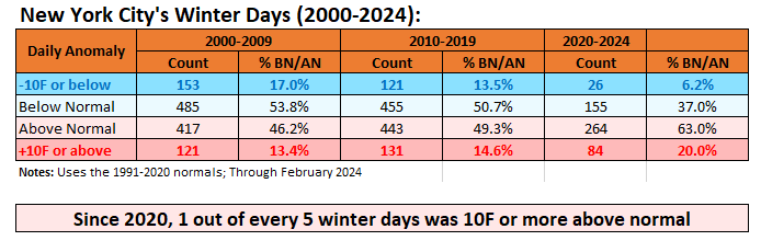
Not just New York City: At Caribou, where winters have warmed 2.9°F over the past 30 seasons, nearly 1-in-3 winter days has been 10°F or more warmer than normal since 2020.
-
Temperatures will rebound into the upper 50s tomorrow under partly to mostly cloudy conditions. Saturday will see temperatures briefly return to near seasonable levels. However, another cold front will likely cross the region on Saturday with a return to cooler conditions. Overall, generally cooler than normal conditions will likely persist into at least the middle of next week. The ENSO Region 1+2 anomaly was -0.2°C and the Region 3.4 anomaly was +0.9°C for the week centered around April 10. For the past six weeks, the ENSO Region 1+2 anomaly has averaged +0.10°C and the ENSO Region 3.4 anomaly has averaged +1.15°C. The ongoing basinwide El Niño event is fading. Neutral conditions could develop later in the spring. The SOI was -5.77 today. The preliminary Arctic Oscillation (AO) was not available today. On April 14 the MJO was in Phase 4 at an amplitude of 0.520 (RMM). The April 13-adjusted amplitude was 0.553 (RMM). Based on sensitivity analysis applied to the latest guidance, there is an implied 70% probability that New York City will have a warmer than normal April (1991-2020 normal). April will likely finish with a mean temperature near 54.9° (1.2° above normal).
-
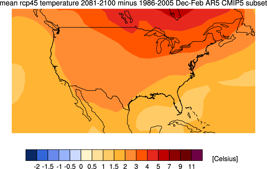
Climate Model Forecasts for Future Winters for RCP 4.5 (most likely scenario):
-
Occasional Thoughts on Climate Change
donsutherland1 replied to donsutherland1's topic in Climate Change
The report didn't mention a synergistic heat wave. -
Occasional Thoughts on Climate Change
donsutherland1 replied to donsutherland1's topic in Climate Change
While some on Social Media continue to dismiss or deny climate change, real world evidence of the consequences of anthropogenic climate change continue to pile up in a growing body of attribution studies. The latest study concerns an extreme heatwave that affected Africa's Sahel Region from March 31-April 4, 2024. The magnitude of the heat was assessed as having been "virtually impossible" in the absence of climate change. Moreover, as the climate warms further, the frequency of such heat is expected to increase dramatically, with such events become a once-in-20-year case. The full attribution study can be found at: https://spiral.imperial.ac.uk/bitstream/10044/1/110771/2/Report 1.pdf -
The above table was broken down into decadal periods:
-
Periods of rain are likely tonight into tomorrow. A general 0.25"-0.50" rainfall with locally higher amounts is likely. Tomorrow will be the coolest day of the week with the mercury struggling to reach 50°. Another cold shot could arrive on Saturday. Overall, generally cooler than normal conditions will likely persist into at least the middle of next week. The ENSO Region 1+2 anomaly was -0.2°C and the Region 3.4 anomaly was +0.9°C for the week centered around April 10. For the past six weeks, the ENSO Region 1+2 anomaly has averaged +0.10°C and the ENSO Region 3.4 anomaly has averaged +1.15°C. The ongoing basinwide El Niño event is fading. Neutral conditions could develop later in the spring. The SOI was -5.77 today. The preliminary Arctic Oscillation (AO) was not available today. Based on sensitivity analysis applied to the latest guidance, there is an implied 69% probability that New York City will have a warmer than normal April (1991-2020 normal). April will likely finish with a mean temperature near 55.0° (1.3° above normal).
-
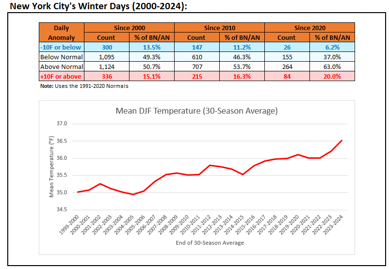
New York City's Warming Winters:
-
Starting tomorrow, it will turn somewhat cooler with unsettled conditions. Thursday will be the coolest day of the week with the mercury struggling to reach 50°. Another cold shot could arrive during the weekend. The ENSO Region 1+2 anomaly was -0.2°C and the Region 3.4 anomaly was +0.9°C for the week centered around April 10. For the past six weeks, the ENSO Region 1+2 anomaly has averaged +0.10°C and the ENSO Region 3.4 anomaly has averaged +1.15°C. The ongoing basinwide El Niño event is fading. Neutral conditions could develop later in the spring. The SOI was -12.91 today. The preliminary Arctic Oscillation (AO) was +2.288 today. Based on sensitivity analysis applied to the latest guidance, there is an implied 63% probability that New York City will have a warmer than normal April (1991-2020 normal). April will likely finish with a mean temperature near 55.0° (1.3° above normal).
-
The temperature soared into the 80s across much of the region today. It was even hotter in the southern Mid-Atlantic region where the temperature topped out at 90° in Norfolk (old record: 89°, 1941) and Richmond. Tomorrow will be another warm day with readings rising toward or above 70°. Afterward, it will turn somewhat cooler with unsettled conditions before a stronger cold shot arrives during the next weekend. The ENSO Region 1+2 anomaly was -0.1°C and the Region 3.4 anomaly was +1.2°C for the week centered around April 3. For the past six weeks, the ENSO Region 1+2 anomaly has averaged +0.28°C and the ENSO Region 3.4 anomaly has averaged +1.22°C. The ongoing basinwide El Niño event is fading. Neutral conditions could develop later in the spring. The SOI was -4.69 today. The preliminary Arctic Oscillation (AO) was +3.405 today. Based on sensitivity analysis applied to the latest guidance, there is an implied 63% probability that New York City will have a warmer than normal April (1991-2020 normal). April will likely finish with a mean temperature near 55.2° (1.5° above normal).
-
Tomorrow and Tuesday will be warm days with widespread readings in the 70s. Tomorrow will be the warmer of the two days with readings rising well into the 70s and perhaps near 80° in the warmest spots. Afterward, it will turn somewhat cooler with unsettled conditions before a stronger cold shot arrives during the next weekend. The ENSO Region 1+2 anomaly was -0.1°C and the Region 3.4 anomaly was +1.2°C for the week centered around April 3. For the past six weeks, the ENSO Region 1+2 anomaly has averaged +0.28°C and the ENSO Region 3.4 anomaly has averaged +1.22°C. The ongoing basinwide El Niño event is fading. Neutral conditions could develop later in the spring. The SOI was -4.69 today. The preliminary Arctic Oscillation (AO) was +3.405 today. Based on sensitivity analysis applied to the latest guidance, there is an implied 63% probability that New York City will have a warmer than normal April (1991-2020 normal). April will likely finish with a mean temperature near 55.3° (1.6° above normal).
-
I ran into some pea-sized hail about 60 miles east of Binghamton.
-
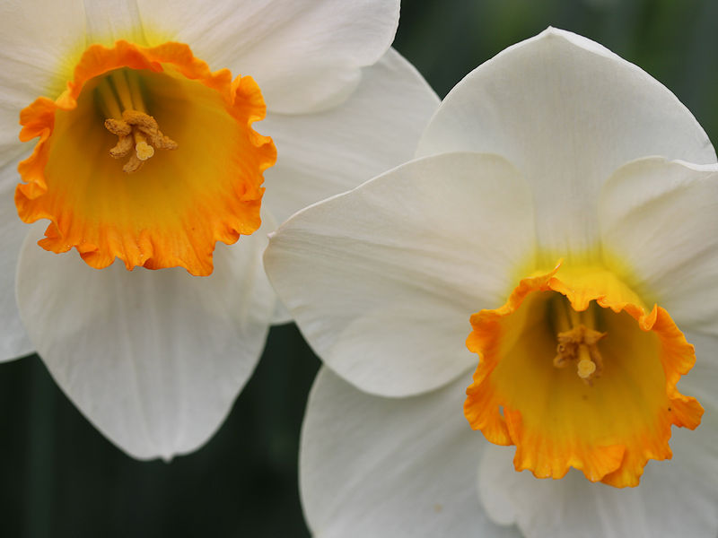
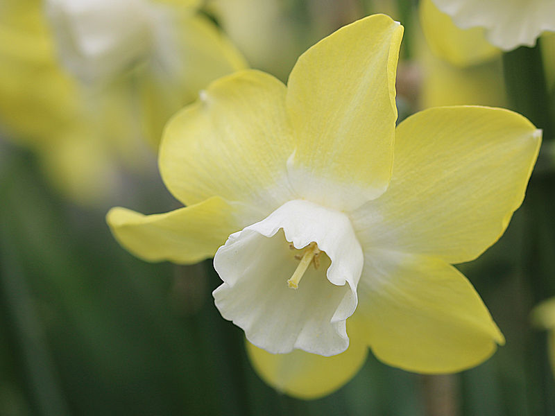
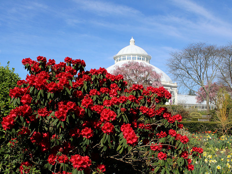
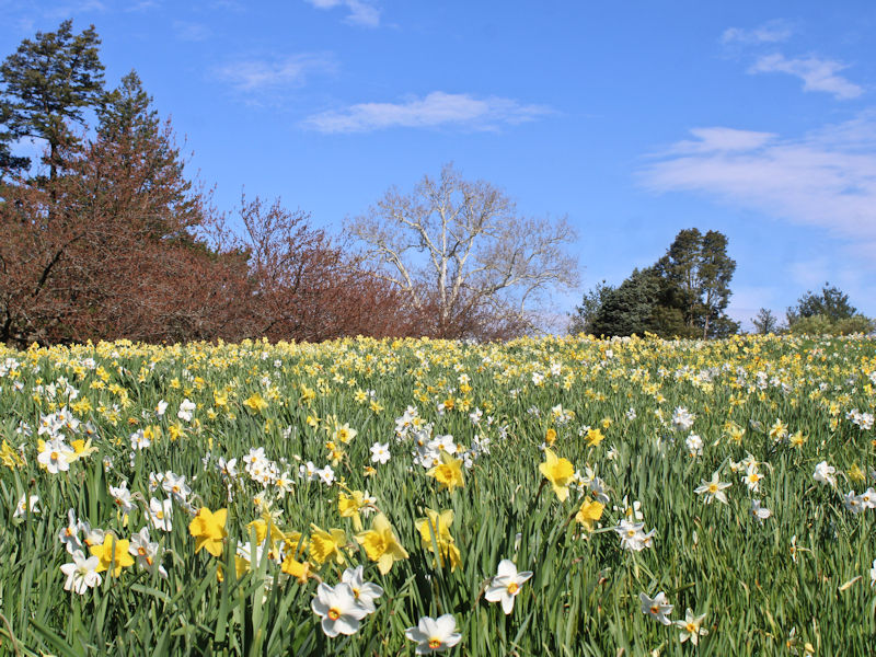
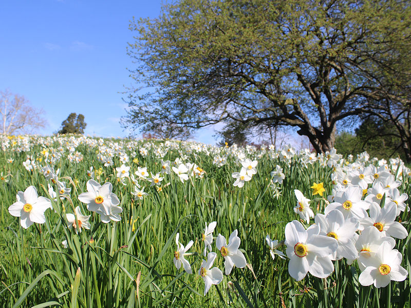
Spring is now in full bloom at the New York Botanical Garden. Some photos from this morning:
-
Occasional Thoughts on Climate Change
donsutherland1 replied to donsutherland1's topic in Climate Change
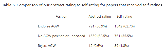
There's more to the story. When the authors of the papers that expressed no view in the abstract regarding AGW were asked to self-rate their positions, more than 60% endorsed AGW. Rejection of AGW languished at 1.8%. In short, very few scientists actually reject AGW. The majority endorse it. https://iopscience.iop.org/article/10.1088/1748-9326/8/2/024024