H2Otown_WX
-
Posts
3,947 -
Joined
-
Last visited
Content Type
Profiles
Blogs
Forums
American Weather
Media Demo
Store
Gallery
Everything posted by H2Otown_WX
-
Agree, D here as well but Ds get degrees
-
Seems like the torch keeps getting pushed back. It was originally gonna torch Tuesday-Thursday and now only Tuesday is gonna be somewhat mild. Wed-Thurs look terrible with the cold front pushing through Tuesday night and looks like maybe a reinforcing BD on Thursday? Weekend looks warm but that's a ways out.
-
Congrats GON
-
Is it just me or does anyone else really want a April Fools '97 redux when looking at Torch Tiger's avatar?
-
It would be cool to hear some stories from peeps who were in the jackpot zone. Well, maybe next year for the 25 year anny.
-
If it's rain, we never Stein. If it were snow we would have gotten half of what was modeled for QPF
-
Albuquerque?
-
Wow, cool recollection. I can't remember details like that. Was there sleet up by me? I'm guessing the cutoff in extreme SW CT is because it was so late blooming? Also, any idea how much liquid fell?
-
Lol, nice weenie over Bristol, Farmington and West Hartford. I think the Thomaston report is pretty accurate. 9 year old me measured 13" in Watertown. Seems like some pretty weird banding stuff going on which makes sense given the dynamics of that storm. You said it lasted 50 hours?
-
Wow, like a different planet up there
-
He seemed like a good guy, I was reading his obituary.
-
It's that time of year again @The 4 Seasons
-
This only has a chance if @ORH_wxman starts posting again
-
I wonder if there are people at NCEP that know just the right combination of bad data to show a KU just to screw with us?
-
I guess forky will have to hide in OT for at least another month
-
Tip made a post this morning about how things are trending away from his signature heat burst. So, good luck.
-
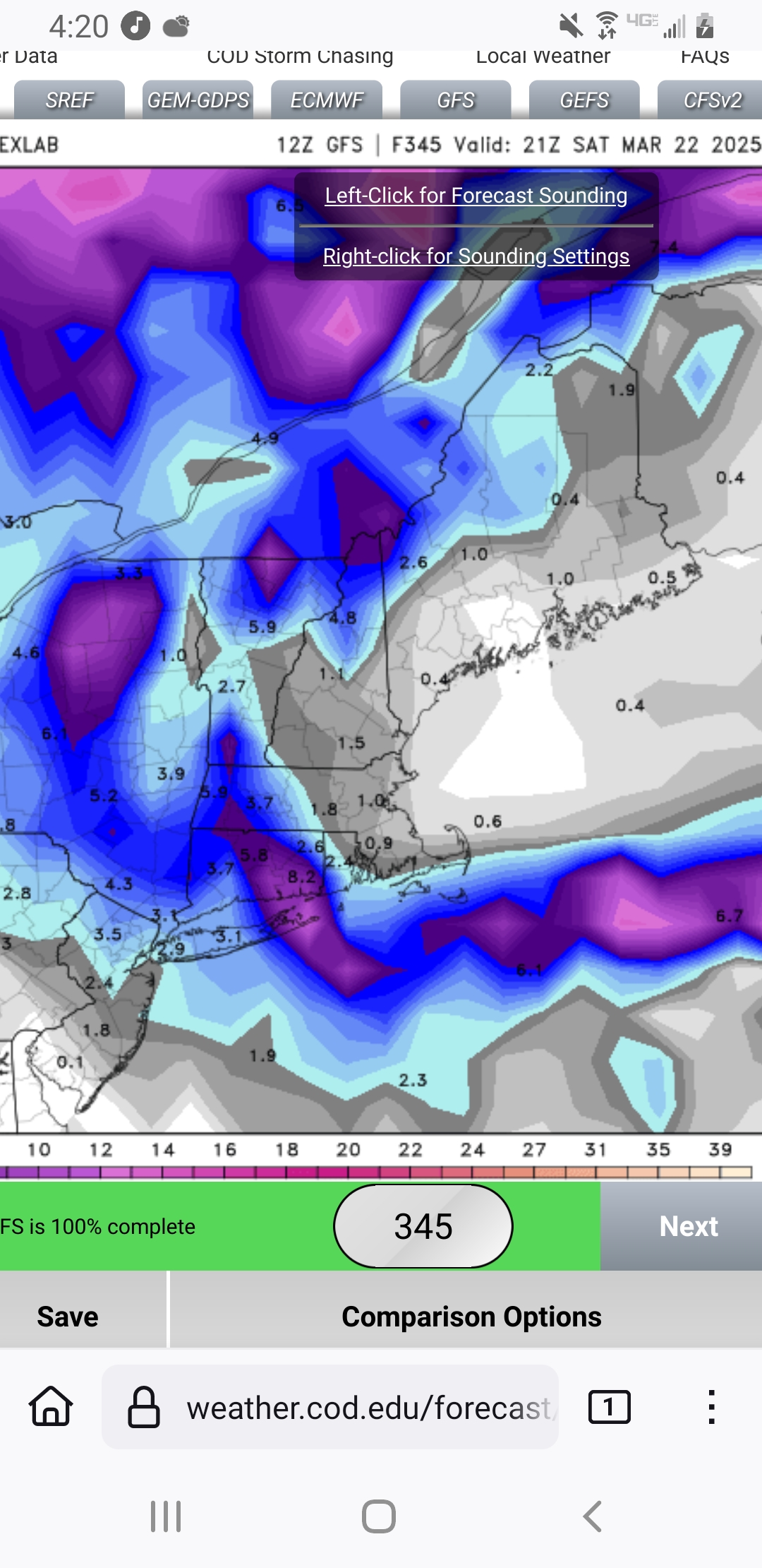
While you guys were wasting time drooling over another fake GFS snowstorm our "big warmup" has now been reduced to one day. The 12th on the Euro and the 14th on the GFS. The GFS has subzero temps on the 11th lol. It shows mostly 30s for highs, this sucks.
-
GFS trying to cancel the torch in the LR. Granted it's just one op run but at the end it has MSP naping nude in the low 60s while we sit in marine mid 40s puke.
-
Seems like a bit of a torch cancel showing up on guidance. I guess that's to be expected this time of year.
-
Only a few days away from the 24 year anniversary of "Here's...the demon"
-
Stop it lol
-
Tippy's heat burst! Could we make a run at 80?
-
I'm sure when March 2018 was about to happen you said this isn't March 2005 or 2003 or 1996
-
63 days remaining in the period or 9 weeks
-
Congrats NNE