OHweather
-
Posts
4,887 -
Joined
-
Last visited
Content Type
Profiles
Blogs
Forums
American Weather
Media Demo
Store
Gallery
Everything posted by OHweather
-
Looks like a nice burst of lake enhanced snow Tuesday night as a shortwave moves through. SW winds will shift NW, so probably just a gradually moving burst with the trough axis transitioning to weaker multi-bands behind the trough. It looks like activity shuts down pretty quickly into Wednesday morning. Instability with the setup is extreme, with lake to 500mb temperature differentials of about 50C along with good synoptic support. The band/burst that crashes ashore with the trough axis probably will be accompanied by some lightning. It seems like this burst could affect much of the snowbelt in NE OH/NW PA (both primary and secondary), along with the Cleveland metro and perhaps some counties farther west along the lakeshore. Most areas probably only see a couple hours of good precip, though sometimes these bands can pivot a bit and last a little longer in a localized area as they work through. Temperatures will be marginal, though with dew points away from the lake falling into the 20s and 925mb temps dipping to -2C I think it will be cold enough for this burst of precip to fall as mainly snow and graupel away from the lake and probably more graupel with some rain and wet flakes mixed in closer to the lake. Forecast soundings suggest there will be good flake production aloft. Along the lake it may be tough to accumulate much as the ratios will be very low, but inland a bit from the lake could see a 1-3" type accumulation across much of the metro area and snowbelt. There may be enough QPF to play with for some of the highest hills to get a little more than that, but they'd have to get lucky and have a band sit over them. It won't last long, but I'm pretty optimistic many of us wake up to some snow on the ground Wednesday morning.
-
We haven’t made the map yet. Hopefully before the flakes start flying at this rate (the data isn’t going anywhere)
-
I will check and see if we produced one. We tallied up all the snow spotter totals but I'm not sure if there's a map to go with it.
-
Was wondering how that band performed when it sank into your area. It snowed hard for a couple hours in Chardon very early this morning, and while accumulations weren't much into Cuyahoga County the heavy snow/graupel in the band made 271 slick during the commute and caused accidents. Luckily the band was moving because if it would've sat in one spot for its duration it may have dropped several very dense inches...we would've needed at least an advisory if not more due to what would've happened to the trees. Pretty impressive setup for May. No accums anywhere between the office and my house (Brooklyn Hts/Reminderville) but we had a nice graupel shower yesterday afternoon and wet flakes did mix in this morning. We've seen snow in the month of May in recent years much more than what I remember up through about 2015. I believe in 2016 we had some May snow that stuck a bit in parts of the snowbelt and then again in 2020, 2021 and 2023. With that said, it's snowing less in the months it is supposed to snow in recent years, probably a trade none of us want to make.
-
Congrats! I have been wondering if we can get into consistently above normal temperatures again anytime soon...just has been an impressive tendency the last couple weeks for blocking/a -NAO pattern which keeps forcing a trough over eastern Canada and the NE US. I do think we'll gradually warm up through May (after the next 7-10 days it shouldn't be a s bad as it is right now) but it'll probably be tough to get prolonged warmer than average weather for a good portion of the month. 6" in Columbus on April 30th is pretty hard to imagine!
-
After the 70s and 80s earlier this month the showery weather with snow flakes mixing in over the last couple of days has been unwelcome. But, nothing has stuck and I think I’m ready to call it a “winter” in Reminderville. My final tally is 33.7”, which is 40-45% of average. The driveway was plowed twice. Definitely feels even more underwhelming than my previous personal “low water mark” in NE Ohio of 2011-12.
-
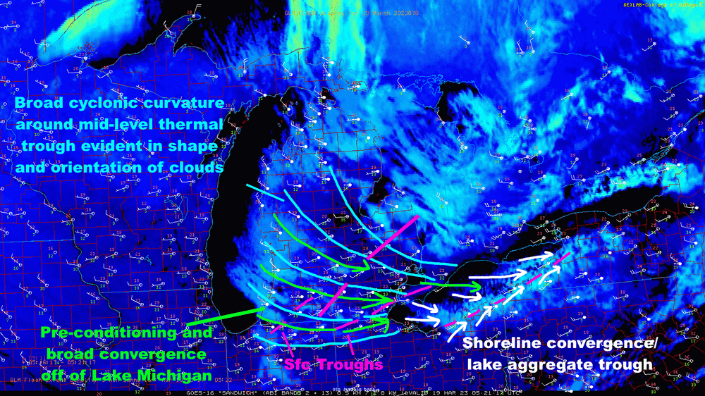
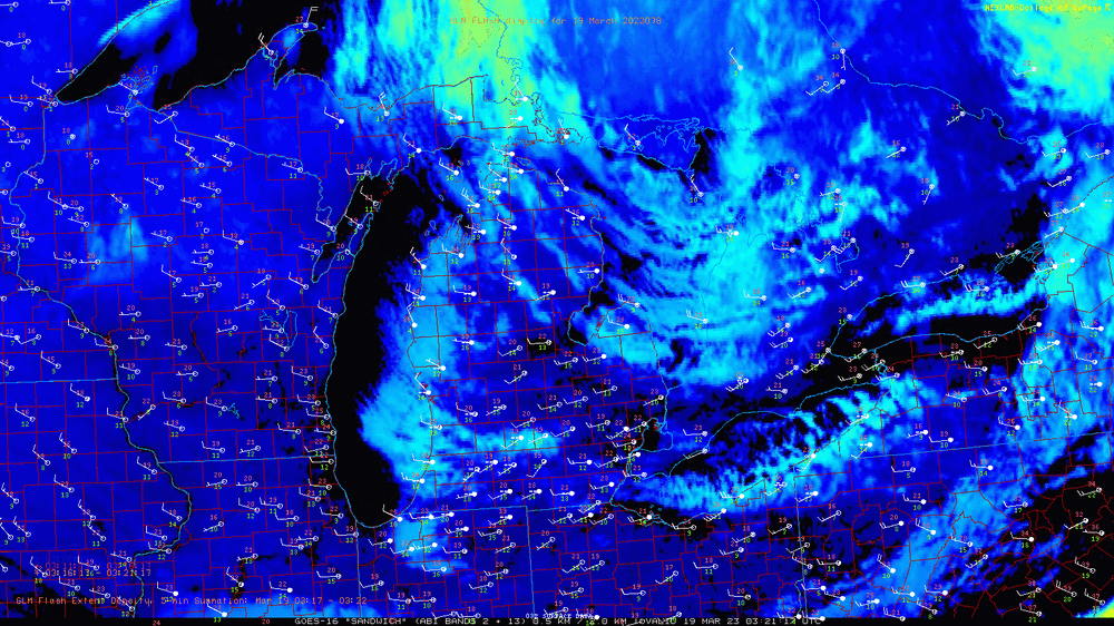
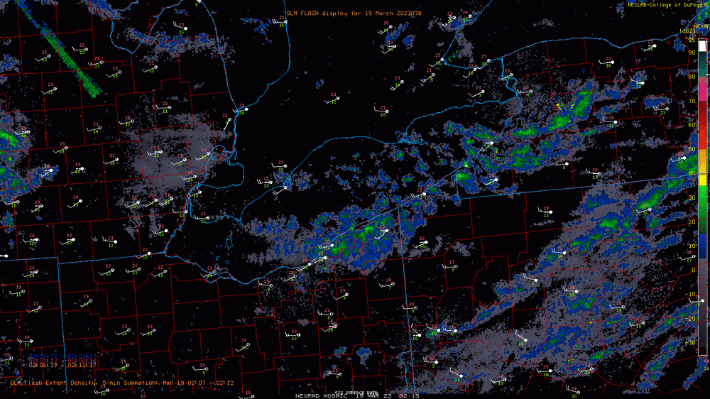
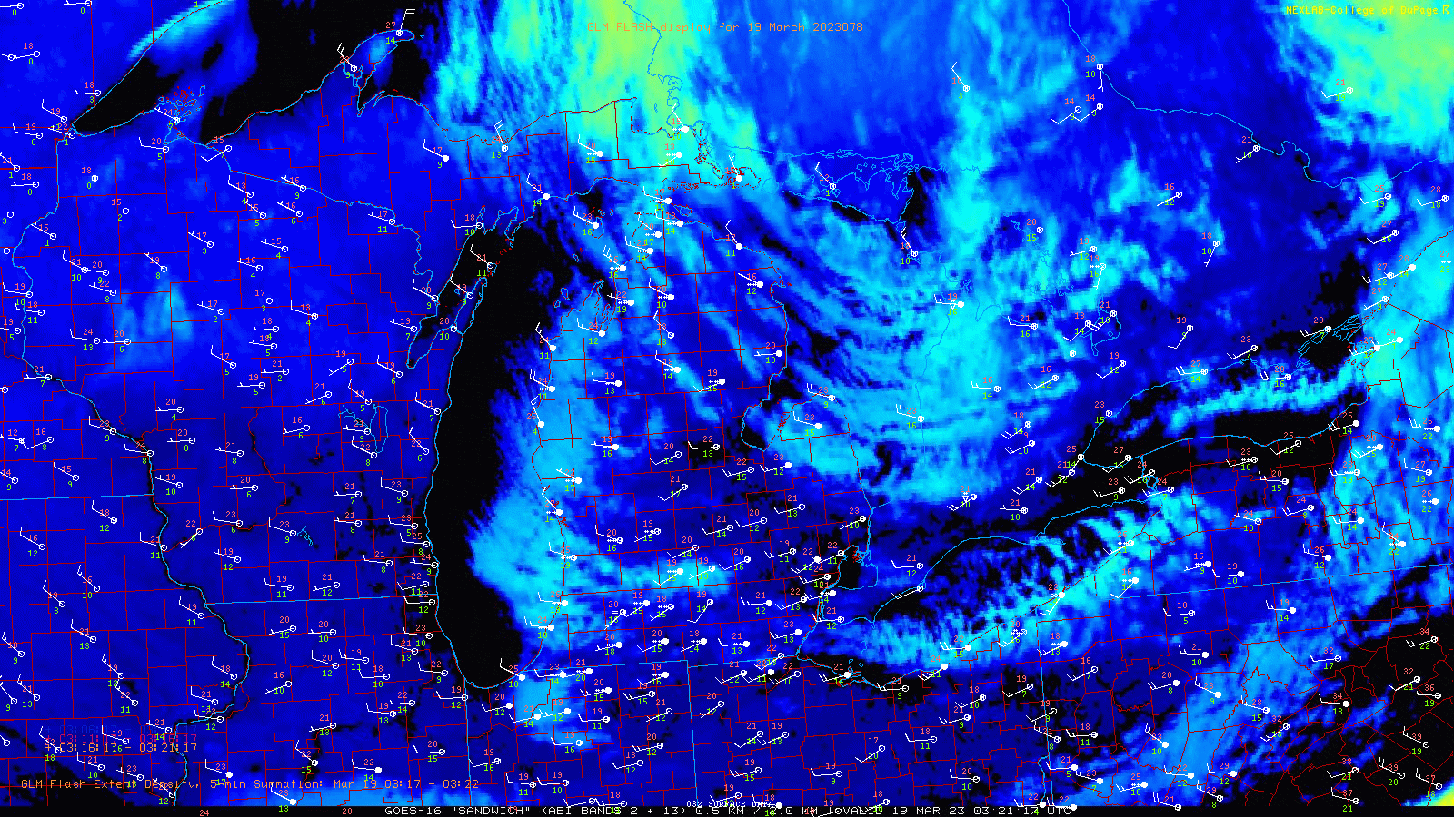
Some subtle features evident on satellite helping our lake effect peak in intensity tonight...unfortunately winds on land are backed to the southwest so it's struggling to push south into more of Cuyahoga and southern Geauga. Basically, subtle sources for ascent and convergence are aligning near and just downwind of Lake Erie as we approach the diurnal maximum in lake-induced instability. This is allowing Lake Erie's lake effect event to peak. Activity may shift slightly farther south as surface troughs over Michigan move southeast across the lake. It's snowing pretty good and I think the warnings will marginally verify in a few spots (probably southern Lake or northern Geauga, and southern Erie or northwestern Crawford), though it probably won't be a very widespread 6"+. This event isn't dropping quite as much as the instability and snow growth could support. Looking at a radar loop and surface obs, some limiting factors are evident. It is a dry airmass and winds are strong with gale warnings over the lake. This is limiting residence time and pushing the snow fairly far inland. However, winds over land are backed pretty far southwest, about 240 degrees, while winds in the lake effect clouds average closer to 280 degrees. This leads to a fair amount of shear, which is limiting band organization somewhat. Winds over the lake are much better-aligned, so I think if the winds were lighter we'd see more focused bands closer to the lake that could drop higher totals. Because of the instability and very efficient snow growth this is a nice little event, just not huge because of the limiting factors (really, lighter winds would've made a big difference).
-
I'll phrase my response to that as: Given the nature of the snows this year (it's immediately settling or melting once it's on the ground) it's been easy to "under-measure" snows in Northwest Ohio if you wait until the synoptic times (i.e. 0z, 6z, 12z, 18z) to measure. Being at an open air field never helps when there's wind either. It's possible there's been a bit more snow in Toledo than the 14.1", though I'd also say it's somewhere in the ballpark even if it's a conservative number.
-
A bit over 4” since Sunday night here, with about 3.5” of that since yesterday afternoon. Not bad. Glad a snow event finally panned out.
-
Late Monday afternoon through early Tuesday strikes me as the kind of setup where a mesoscale surprise happens somewhere from the central lakeshore counties and Cleveland area points east-southeast towards Trumbull and Mahoning Counties and into western PA. Really good lift and instability under an upper trough as a surface trough drops southeast across the lake could cause quite an enhanced band to come onshore and then "train" along the surface trough axis, leading to a localized swath where moderate to heavy snow lasts a few hours. Could see a swath of locally over 4" of snow. It will be quite convective and should easily accumulate as the sun sets.
-
Areas where the bulk of the snow occurred during the daylight today mightily struggled...we used fairly low snow ratios to come up with the forecast but it was still way too much snow outside of the higher terrain. Had an inch or so here based on what's left in shaded areas. I don't know enough about the climate stuff discussed on the prior page off the top of my head to chime in, but will read through it and see if I can come up with anything.
-
I was on the desk today and one can see where there are advisories now in our CWA. Can add that the reason midnight shift didn't issue more advisories was due to feeling the set-up is fragile (due to temps) and the snow accum forecast uncertain more so than not thinking the forecast would warrant one if it held. Nothing major changed today (the forecast held) so advisories were expanded. Snow was still 24 or so hours out early this morning so midnight shift didn't necessarily need to issue advisories yet. I can see an argument that maybe not issuing just for Lucas (which some may have found misleading) and holding off altogether would've been better, but Toledo was completely boxed in otherwise and they felt confident enough that Lucas was pretty fail safe which is why they did what they did.
-
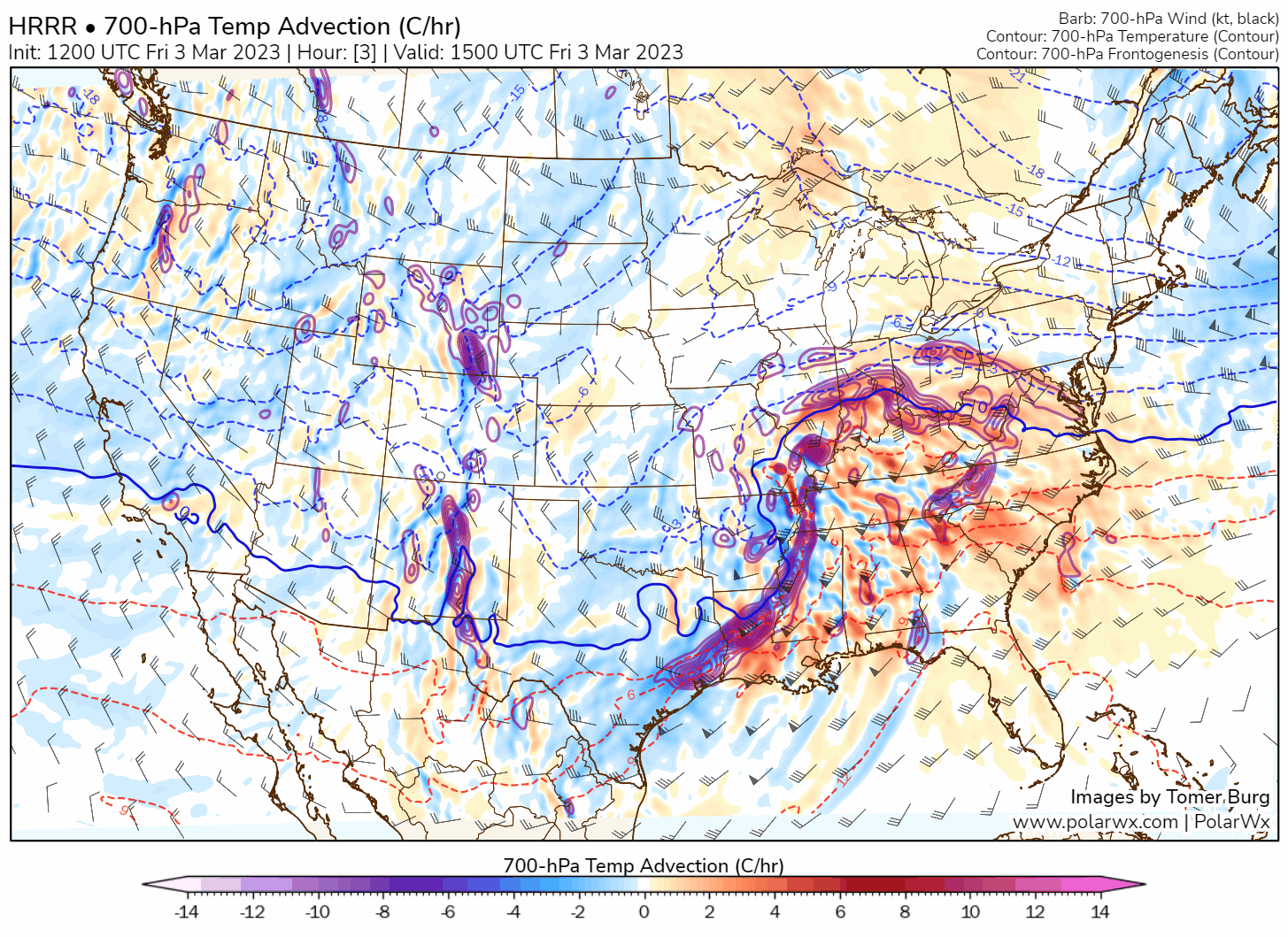
To both of these points, soundings off of Lake Michigan do support some marginal lake enhancement...there's a conditionally unstable layer up to about 900mb and while it isn't much (or into the DGZ), it's modeled to be saturated which if accurate would at least contribute some precip production. Since flakes are being made aloft and seeding the lower level lake enhancement, those low clouds will be able to make flakes and add some amount of snow. It won't be a ton, but over the course of several hours maybe is an extra inch or two. Models briefly have a rather similar look off of Lake Huron so there probably will be some enhancement, but it's similarly marginal...and the synoptic precip starts shutting off quicker so the lake enhancement may not last long off of Huron. Since it won't be that intense it may just not be able to add more than an inch?
.thumb.png.fa78ce8c20716e177e2032e18abb2eab.png)
.thumb.png.292697f42a4af86a439eadff5c29d259.png)
-
To your point, an argument could be made that there should've been a Wind Chill Warning (along with or perhaps instead of a Winter Storm Warning) since the cold was just as big of a hazard, sure. Unfortunately, it's not entirely consistent when offices issue cold headlines separately from or included in other winter weather headlines (some offices try not to issue both at once, others sometimes issue both at once). I think in that case the Winter Storm Warning was locked in more than a day out when the snow looked somewhat more impressive. In our area we figured about 2" of that snow led to enough blowing snow to necessitate a Winter Storm Warning, though we had prolonged 40-55 MPH wind gusts which may have been a bit stronger than what you had.
-
The pre-Christmas storm was absolutely worth Winter Storm Warnings btw...it wasn't much snow (yes, less than expected), but it was blowing around quite a bit for a day and a half with brutal wind chills. There was a prolonged period where travel was hazardous in any kind of open/windy area with dangerous cold causing infrastructure issues. It was a distinctly elevated risk to life and property for those not prepared for the conditions and lasted a solid day and a half. It was worth the warnings even if the impacts weren't as significant as what looked possible a couple days out. For this one, it's the short duration and marginal boundary layer that's the issue. The lift and moisture are good, agree with Stebo there should be some banding on the east/northern flanks, but it just won't last long and won't be extremely efficient so it'll be hard for many to get 6"+. It'll snow hard and be a wet/picturesque snow (though not quite as wet as last Friday's) but the totals will mainly be in the 3-6" range IMO. The area that could *locally* get 6"+ is near the western Lake MI shoreline where some lake enhancement will be in play, especially if banding can pivot over that general area. That'd be enough for a narrow 6"+ lolli just inland from the lake in WI or NE IL.
-
Going away would imply that it was ever here! I actually think this could be a warning-level snowfall for the primary snowbelt (and probably Cleveland metro too) if we see the southern low track advertised by the GFS and Euro, with at least a good few inches of synoptic snow Friday followed by wrap-around and some lake enhancement Friday night. However, the NAM/RGEM/CMC are a little farther north with the low track and bring a dry slot and some rain up to the lake even in northeast OH for a few hours Friday afternoon and would maybe more of a sloppy system with probably more of a casual advisory snow. The blocked pattern over eastern Canada and the north Atlantic at least leaves the door open for the southern track, but the bologna is sliced pretty thinly. Curious to see what today's 12z runs show. Suspect the NAM/RGEM are too amped but could see some sort of a compromise solution in which the GFS/Euro tick somewhat warmer.
-
Euro just bumped south. Friday is getting interesting.
-
Was looking at the HRRR positive depth change, it did pretty well yesterday morning with the max swath (and maybe was just a tad too low on some on the fringes in eastern IL?). I thought the rates/QPF could support12”+ lollis where the band would pivot between N IN/SE MI/S ON (figured when rates were really heavy ratios would come up enough to allow for that kind of accumulation) but it seems like about 11” of concrete was the most anyone could muster.
-
Guessing it's mainly because their focus is on the severe wx in the Ohio/Tennessee Valleys as opposed to not expecting this/not thinking it's worth an MD.
-
I wouldn't have bet money on the 70mph gusts in IL on the north side of the low ahead of time either, but throwing out 50mph and hoping that holds when there was a pretty coherent hi-res signal for at least 60mph (with the HRRR consistently advertising the potential for 70+ exactly where it happened) is pretty blegh given the borderline rapid deepening and very anomalously low MSLP values...that were fairly well-advertised.
-
Frankly was miffed (and still am for some areas from NE OH into NW PA/SW NY where wind headlines STILL haven't been hoisted) at how conservative some offices have been with wind headlines on this one, outside of offices south of the Ohio River where warnings went up much earlier. Maybe when we're setting record low pressures it's a good sign to just issue the darn wind headlines. Hi-res models had gusts as high as what's been measured...I get that sometimes they're overdone but it's rare that a <980mb low isn't a giant wind bag.
-
It's not a proper "heavy wet snow" unless it can cover roads despite air and ground temps being above freezing. That's my rule of thumb at least
-
An argument could be made for a swath of High Wind Warnings from central IL across central/northern IN into NW Ohio for the next several hours. Hi-res models have been insistent on a broad corridor of 50-60 MPH gusts just N/NE of the low track this afternoon and early evening and the wind will have an easterly component, which with a wet ground which may make it easier to topple trees. Kind of an interesting set-up because it's all driven by the tightening pressure gradient and unusually strong isallobaric flow (blowing towards the rapid pressure falls from the SW) as opposed to mixing down stronger flow aloft...now that we're starting to see some 40-50+ knot measured gusts I think it gives credence to the idea.
-
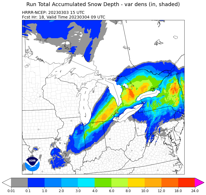
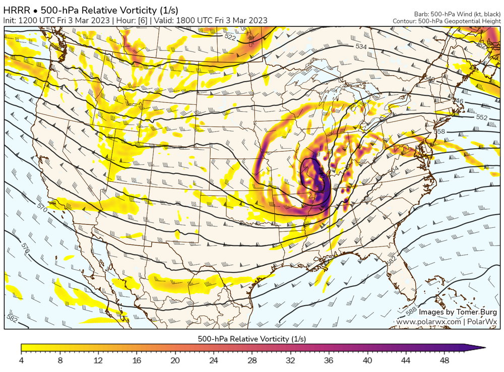
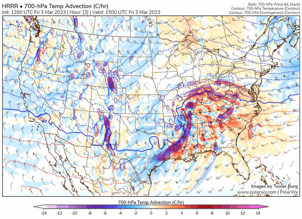
This is disappointing for Chicago and surrounding areas (while it's still close for the southern suburbs, it will be an extremely sharp western/northwestern cut-off) but for those that cash in, this will be nuts. Seems like it starts getting good somewhere over far eastern IL or northern/western IN. With an outside-of-early-March-climo low pressure tracking through the Ohio Valley ahead of an extremely sharp, negatively tilted shortwave and deepening considerably while ingesting and lifting a very moist and somewhat unstable airmass precip amounts will be impressive. The lift is progged to be maximized in the DGZ in the deform band that will peak in intensity from northern IN into southern/eastern lower Michigan, southern Ontario and northern NY this afternoon and evening. While it's too warm to snow now, dynamic cooling will be more than adequate later. This sounding supports production of all ice crystal types due to saturation and lift through an incredibly deep layer. However, with very impressive lift maximized in a weakly stable DGZ to go along with a deep 0 to -5C layer in the low-levels dendrite production will reign supreme aloft and large aggregates will result by the time they reach the surface. This kind of heavy snow with large flakes will have no problem cooling surface temps to 32-33F under the heart of the band once it gets going. Hi-res QPF guidance suggests 3-hourly precip rates of 0.75-1.25" in a narrow zone in the deform band as it peaks in intensity from northern IN and southern/eastern lower MI into southern ON this afternoon and early evening, with peak hourly rates of 0.25-0.50" implied. Snow ratios will probably be ~8:1 under the heart of the band when rates maximize (and will otherwise be less), suggesting hourly snow rates of 2-4" an hour are possible (if not likely) in a narrow zone where the snow band is heaviest. This will be 2-4" per hour of very heavy, wet, substantial snow. Outside of the heaviest band slightly warmer surface temperatures and lighter rates will lead to lower ratios and sharp snowfall gradients. While it seems like somewhere from northern/western IN (perhaps starting in far eastern IL) into southern/eastern MI and southern ON/northern NY will all be impacted by this heavy band, there's a consistent signal it will pivot somewhere over northern IN or southern/eastern MI. Where this occurs, 2-4" per hour rates will last a good 4-6 hours and storm totals jackpotting 12"+ (not sure what the max possible amount is given low ratios and marginal surface temps, maybe 16 or 18"?) are likely. Where this band pivots and the higher amounts occur it will be a crippling snowstorm as roads will be nearly impassable by late afternoon/early evening due to rapid accumulations of heavy, wet snow...and due to what will likely be more widespread tree damage and power-outages, given what will be an excessive amount of very sticky snow to go along with wind gusts over 40 MPH at times. My gut feeling is that Detroit proper will get several inches (3-6") of very wet snow with amounts quickly increasing to the west/northwest due to less urban influence and slightly more elevation.


.thumb.gif.b319dfc6b6278dc71be207ee970e3d22.gif)
-
This winter has felt worse than 2011-12, and I believe the numbers show that (this winter was definitely a bit warmer, and snow has been at least a bit less across the board, especially in the snowbelt). 11-12 was my prior "low benchmark" in this area. 19-20 was much worse where I was living in NJ (we got about a foot for the winter, average where I was living was probably 40-45"), but their climo baseline is warmer/less snow than here.


.png.b366c61686b02c73ed93e82f113057d3.png)
.png.8fefd73b07db4e0a6e0843d1507fbacb.png)


.gif.7688c082bad9b32b76a861d0b1c1b544.gif)