frd
-
Posts
6,928 -
Joined
-
Last visited
Content Type
Profiles
Blogs
Forums
American Weather
Media Demo
Store
Gallery
Everything posted by frd
-
Yes, it was windy yet again.
-
Winds forecast globally. May to July 2025
-
As per X our area is under some of the coldest air on the planet. ha ha, but OK. Way to go JB you nailed it bro.
-
Damn a gust front advisory leading to a special marine warning pecial Marine Warning ANZ530-531-538-539-152045- /O.NEW.KLWX.MA.W.0028.250415T1845Z-250415T2045Z/ BULLETIN - IMMEDIATE BROADCAST REQUESTED Special Marine Warning National Weather Service Baltimore MD/Washington DC 245 PM EDT Tue Apr 15 2025 The National Weather Service in Sterling Virginia has issued a * Special Marine Warning for... Chesapeake Bay from Pooles Island to Sandy Point MD... Chesapeake Bay north of Pooles Island MD... Chester River to Queenstown MD... Patapsco River including Baltimore Harbor... * Until 445 PM EDT. * At 245 PM EDT, gust fronts were located along a line extending from near Gunpowder River to 10 nm southwest of Fort Smallwood State Park, moving southeast at 25 knots. HAZARD...Wind gusts in excess of 48 knots. SOURCE...Radar indicated. IMPACT...Boaters could easily be thrown overboard by suddenly higher wind and waves capsizing their vessel. Boats could suffer significant damage in high winds. * Locations impacted include... Fort Smallwood State Park, Pinehurst, Turkey Point, North Point State Park, Magothy River, Hart Miller Island, Dobbins Island, Gibson Island, Bodkin Point, Tolchester Beach, Worton Point, Pooles Island, Spesutie Island, Love Point, Gunpowder River, Sandy Point State Park, Baltimore Light, Northeast River, Sevenfoot Knoll, and Chester River. PRECAUTIONARY/PREPAREDNESS ACTIONS... Move to safe harbor immediately as gusty winds and high waves are expected.
-
Wind advisories have been posted for the Eastern areas now
-
Winds starting to pick up here. Appears we are nearing some clearing before a line of showers possibly moves through later. 63 F with a dew point of 47
-
Interesting wording by Mount Holly Looking at the radar the strong upper level energy is now entering Western PA. and Western VA. moving East quickly. This atmospheric setup will allow for a few things to occur... 1) A well-mixed boundary layer will allow wind gusts across the region to reach into the 30-45 mph range... 2) Any stronger showers that develop will be capable of producing stronger wind gusts locally given the transporting of stronger winds aloft down to the surface along with some evaporational cooling taking place within the downdraft... 3) Any strong showers or convective cells could be capable of producing some small hail/graupel given some instability combined with favorable low and mid level lapse rates along with lower freezing levels. SPC has introduced a marginal risk across portions of eastern Pennsylvania and northern New Jersey for severe weather this afternoon due to the potential for an isolated thunderstorm producing damaging winds. High temperatures on Tuesday will be in the upper 50s to mid 60s.
-
I am so much enjoying this majority of cloudy weather. It does so much for my mood. Not !
-
Well, on a positive note some clearing moving in quick from the West during the next few hours. Tomorrow starts with clouds, but sunny conditions should increase in the afternoon, as the winds increase significantly.
-
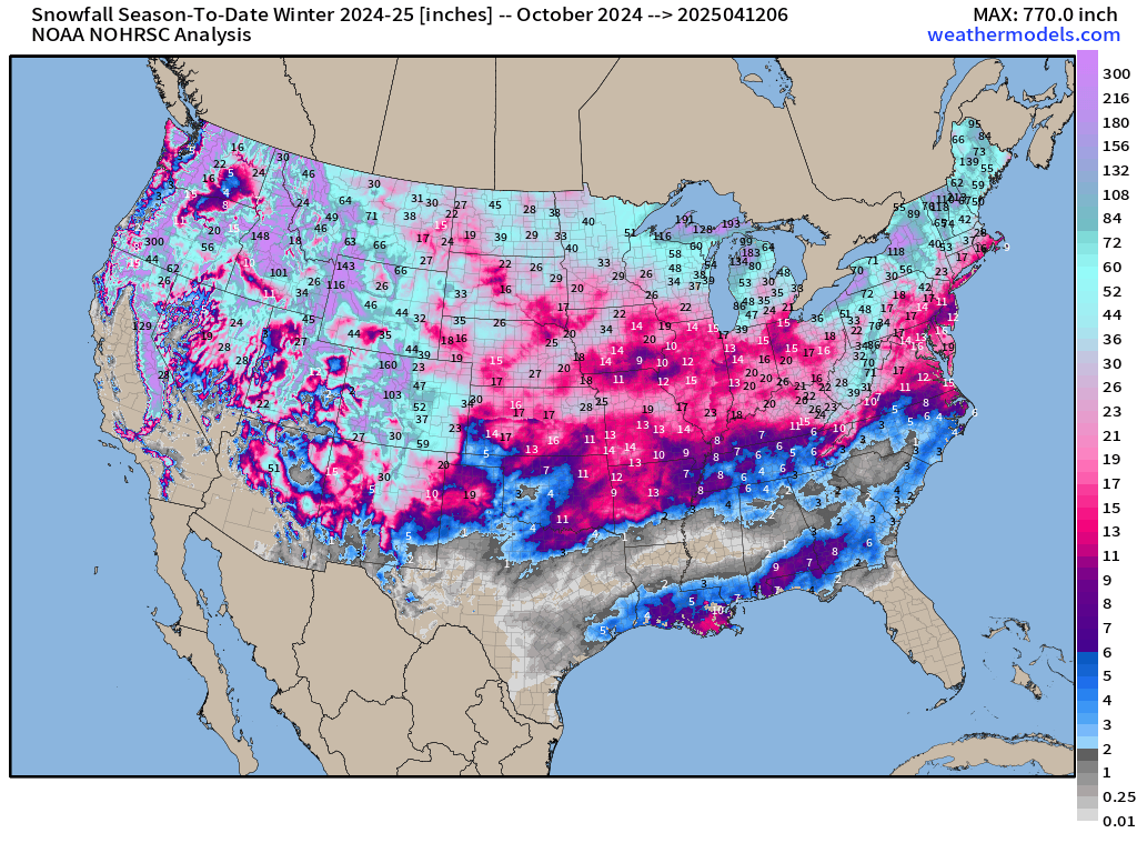
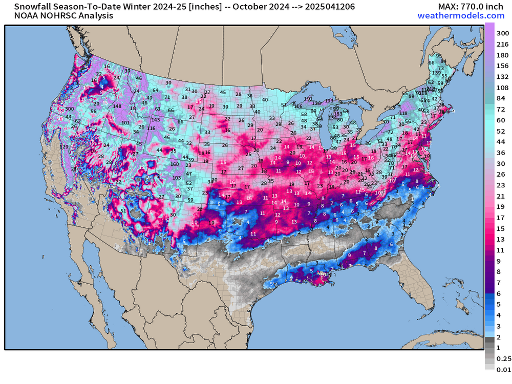
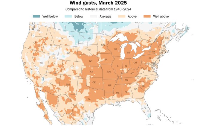
We are good at clouds too. Majority of the last 20 days have been cloudy. March was the windiest month in 50 years at some locations.
-
Mount Holly has increased their rainfall forecast compared to yesterday. I have not looked at the modeling, but it looks like there's a better chance of rainfall now.
-
Still snowing to our North.
-
1.78 inches here. Chilly out there this morning. Tomorrow is Rehobeth's 5 K. Good luck to those participating including my daughter. Next after this is the Broad Street run in Philly. Sunday morning hopefully better than this morning at the beach.
-
I thought even for March it was very windy.
-
Long range models look to delivery yet another cold blast next week. Frost and freeze threat is not over.
-
We will issue a Freeze Watch for most of our Delmarva counties (with the exception of the Delaware Beaches and New Castle County DE) since the growing season is considered to have officially started there. In the tier of zones just to the north and east, the start date isn`t until the 11th.
-
The favored corridor that existed during the winter going across the central Eastern shore to Dover and slightly South seems to be the same area this morning receiving the better rainfall. Rain has picked up in intensity here recently. Looks to continue for several more hours. The grass is excessively tall. Looking forward to 35 to 40 mph wind gusts tomorrow to help dry things out.
-
Significant rainfall chance next Friday and Saturday.
-
Higher elevation snows on Tuesday possible, also snow showers to the far NW. A secondary cold front Monday night may end up moving through our area with little in the way of precipitation with it as the deeper moisture is shoved offshore with the earlier front. Given the strength of the incoming upper-level trough however, cannot ruled out some lingering light rain showers (snow showers across the far northwest) Monday night and early Tuesday morning. Low temperatures by Tuesday morning will be mainly in the 30s. While temperatures in the mid 30s are forecast all the way south into Delmarva, it will be too windy and dry for any frost formation.
-
https://x.com/RyanMaue/status/1907793713801077104 Damn that SE ridge ! Several days of deep layer moisture feed out of the Caribbean and Gulf into the lower/mid-Mississippi River Valley leading to extreme rainfall totals. Blame the "high pressure/ridge" off Southeast U.S. coast for blocking traffic and directing the massive atmospheric river.
-
Looking like a wet weekend pattern going forward. Also, no way to be able to mow or do early crops.
-
Very small area of clearing. Moving across Northern northeastern Maryland into Northern Delaware won't last long, but temperatures have come up a bit since the sun has showed itself
-
Looks like .28 here
-
Getting hit rather hard this morning. Initial line of storms maybe 4:00 a.m. secondary line of storms that were stronger hitting the area around 6:10 a.m.
-
Mostly NW of us. But, better than nothing, just wish it would not be cloudy every day.