

Birds~69
-
Posts
34,319 -
Joined
-
Last visited
Content Type
Profiles
Blogs
Forums
American Weather
Media Demo
Store
Gallery
Posts posted by Birds~69
-
-
Yeah, just going outside you can just hear dripping, drainpipes flowing and a couple birds chirping...depressing.
42F
-
 1
1
-
-
Damn, some rain moving in?
This week will be depressing w/temps in the 40s (50s?) and rain over the weekend with no real signs of snow...
35F

-
1
-
-
9 minutes ago, KamuSnow said:
Oh yeah.
If you ever decide to invest in a "Mildo" snow making machine, I'd pay money to see the expression on their face. Most people try to rid themselves of snow...meanwhile you're pumping it out at full throttle and creating large piles. You may see "For Sale" signs popping up around your house after you have a foot accumulation/large piles while the neighbors lawns are bare. Kids would dig you though...
-
 1
1
-
 1
1
-
1
-
-
1 minute ago, KamuSnow said:
Lol, the one neighbor doesn't say anything but he's said in the past "you're doing what you enjoy" in reference to other things (we're always outside working on this place and we love it, in fact we're having a kettle fire right now).
The other neighbor actually has a plow and over the years has made passes through here which I appreciate (we help each other out). But there have been times when I've asked him not to, including this month, and I have no idea what he says to others, but he does know that we like to make piles lol.
Lol...that's funny!
Probably says to other neighbors "What the hell is that grown man making large piles again? I told him I would plow it." (If he only knew:)
Sounds like you're cool w/them and vice-versa so all is good...
-
1
-
1
-
-
2 minutes ago, KamuSnow said:
Lol, I had that thought, but I worked my butt off to get it that size, and that record may stand (here), so why keep it a secret. This is the place for sharing crazy weather stuff after all : -).
I've been doing fun things with snow for a looong time!
Hell no, enjoy it!
-
Kamu, are your neighbors close by to view the pile? If so, do they question your motive?
I would know right off the bat....weenie galore.
-
1
-
-
Just now, Birds~69 said:
Show off!
^ Nice job!
-
1 minute ago, KamuSnow said:
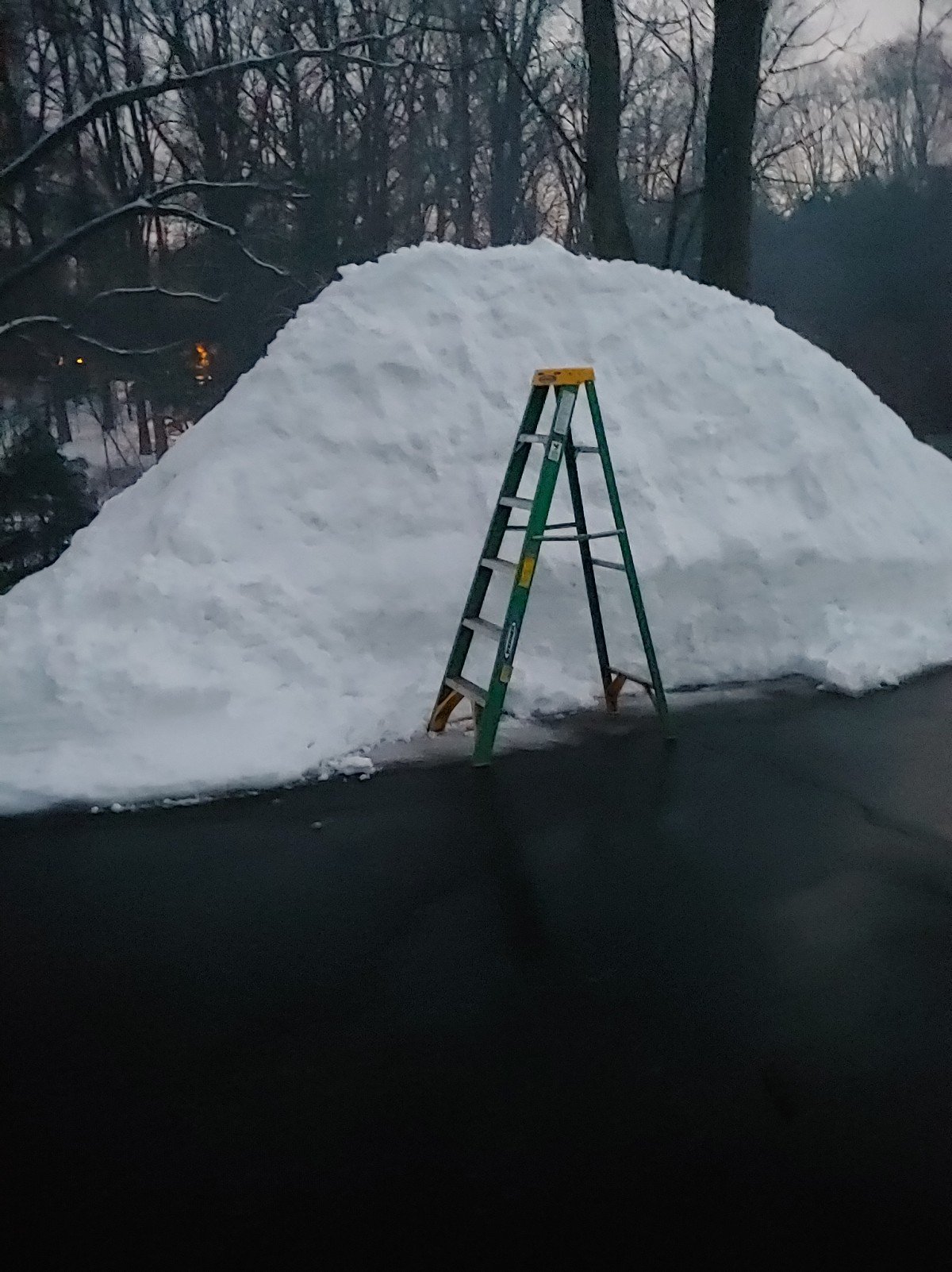
Here is the snow pile, a new record at just over 8ft high! Now I'm ready for a couple days of rest, lol. (I used a 6ft stepladder to measure it).

Show off!
-
1
-
-
Hvy snow/ 33F /4 - 4.5"
Spotter in Skippack 5.5"....just saw it on 6abc as well.

-
Still mod/hvy snow/32F
I would think Philly had to flip over by now. When that happens I'm usually 1/2 hr away, if not sooner.
-
13 minutes ago, BBasile said:
Made the changeover. Went straight to rain. 0.25" of snow before it did. 33.4F
It appears the changeover line is moving rather quick. Glenn thinks changeover in Philly 12- 12:30pm and calls it a "Springtime snow"...
31F / Mod/heavy snow
-
Just now, KamuSnow said:
Also true. Snow is getting steadier here now, still relatively small flakes.
Just started here...
31F
-
Just now, KamuSnow said:
Might be okay - most of rush hour is past, warmer in the pm, mid day thru early afternoon for cleanup. Could be not too bad.
Many work from home as well compared to years past...
-
This is going to be a nice snow wall coming...some "pinks" starting to show as well.
31F

-
This definitely looks like a thump on radar. Goes from nothing, then snow to steady/heavy snow real quick...
31F

-
Just now, Ralph Wiggum said:
Sounds like sun angle won't have much of an impact until after the fact
No doubt, this will stick. We're not in Mid-March+ sun angle territory yet...
-
2
-
-
Just now, The Iceman said:
I'm sorry but if they are expecting 1-2"in a hour to fall, they really need to update those areas to winter weather advisory. Don't understand why they are erring on the side of caution here... Going to be a lot of people complete caught of guard as is...
I agree.
The radar really juiced up within the past hour...waiting for the thump.
31F
-
NWS 8:46am update...including Philly/Del so more south.
32F

-
Snowing in Lancaster, radar looks solid. Nice returns around the M/D line...
31F


-
1
-
-
1 minute ago, Ralph Wiggum said:
I thought I read somewhere that reed timmer (chaser) hinted this would be a late start for severe but also that there is a higher risk for more extreme/historic outbreaks?
I have no idea how they could possibly predict this. Maybe some insight but certainly wouldn't take it too seriously. Much like winter outlooks which fail more times than not..
-
As l
9 minutes ago, Ralph Wiggum said:Only thing worse is reading you complain about for 5 months

As long as we receive a good amount of T-storms/severe weather I'll keep myself in check...
31F
-
2
-
-
1 minute ago, Ralph Wiggum said:
Extended ens means show what the Feb pattern was 'supposed to be in a Nina heading into March. SER, 50/50 high, -PNA, TPV anchored over the N Pole. All signs point to an early spring for a change. That would be awesome! I like fishing for early April striped bass and weakfish in the 50s and 60s not the 30s and low 40s.
I like all of that as well if it stays in the 50s or 60. I just don't want a early blow torch which last though Aug/Sept. Nothing worse than a looong Summer...
* Just noticed my income tax return was deposited into my bank account overnight. Today's storm could fail completely and I'll still be in a good mood...
-
1
-
-
3 minutes ago, Ralph Wiggum said:
Latest hrrr colder....95% snow now with 4" here. Probably mostly on old snow but a nice refresh. All guidance on board for 3-6" here now. I dont buy it. My bar is set at 2.5"
28F
I'm just looking forward to a couple hours of snow at good rates and yeah this be last we see flakes for some time. Weekend looks wet w/temps near 50F...
-
1
-
-
Just now, Ralph Wiggum said:
27F here. Plenty cold. Should be a nice quick thump then we welcome spring?
Reading 31F


E PA/NJ/DE Winter 2020/2021 OBS Thread
in Philadelphia Region
Posted
Imagine tomorrow w/the highs 50F+ and sun. Lord have mercy on any snow pack....