WxUSAF
-
Posts
28,636 -
Joined
-
Last visited
Content Type
Profiles
Blogs
Forums
American Weather
Media Demo
Store
Gallery
Everything posted by WxUSAF
-
This is the white Christmas so enjoy it weenies. I’m going to put some music on, bake cookies, wrap presents, put a fire in the fireplace, watch my favorite football team piss down their legs again, and we’ll have the hap hap happiest Christmas since bing crosby tap danced with Danny fucking Kaye.
-
I’d vote for a thread for Sunday
-
I’m modestly confused why WBAL in Baltimore has a temp range of 29-32 on Sunday. That’s the high and low. 0z euro has mid-upper 10s by 0z Monday.
-
So 18z euro is drier, warmer, about the same, or best yet?
-
Happy hour smashes a bottle over Maryland’s head
-
Going to assume 20-30:1 ratios based on my last snowfall
-
Not sure if it’s the coastal per se or just good dynamics (jet entrance region and frontogenesis). They’re all linked of course. Maybe. Seems like Sunday is the stronger wave. @SnowenOutTherehas the hot hand. I did the December 2nd rain thread
-
Nice consensus at 12z. Now just needs to hold for 90 hours.
-
Euro AI is consistent with the idea of coastal development on Sunday. Definitely the solution PHL-BOS is rooting for. Don’t know how much snow for our area. Probably 1-3”ish?
-
0z and 6z euro looked a lot like gfs and ukie?
-
Nice right entrance region of the jet max over us also around 6-12z on the gfs.
-
Something like that is showing up in the euro too. Tiny coastal enhancement? Need a 20-30mi north shift though.
-
Yeah, I think that was the coldest Xmas of the 20 year period and it was the worst snowfall year ever for MBY.
-

12/12: The little Friday clipper that could? Or won't.
WxUSAF replied to dailylurker's topic in Mid Atlantic
Gonna ignore the white dot over my house -
Uh, well it Fs us both pretty badly, but other people cash in
-
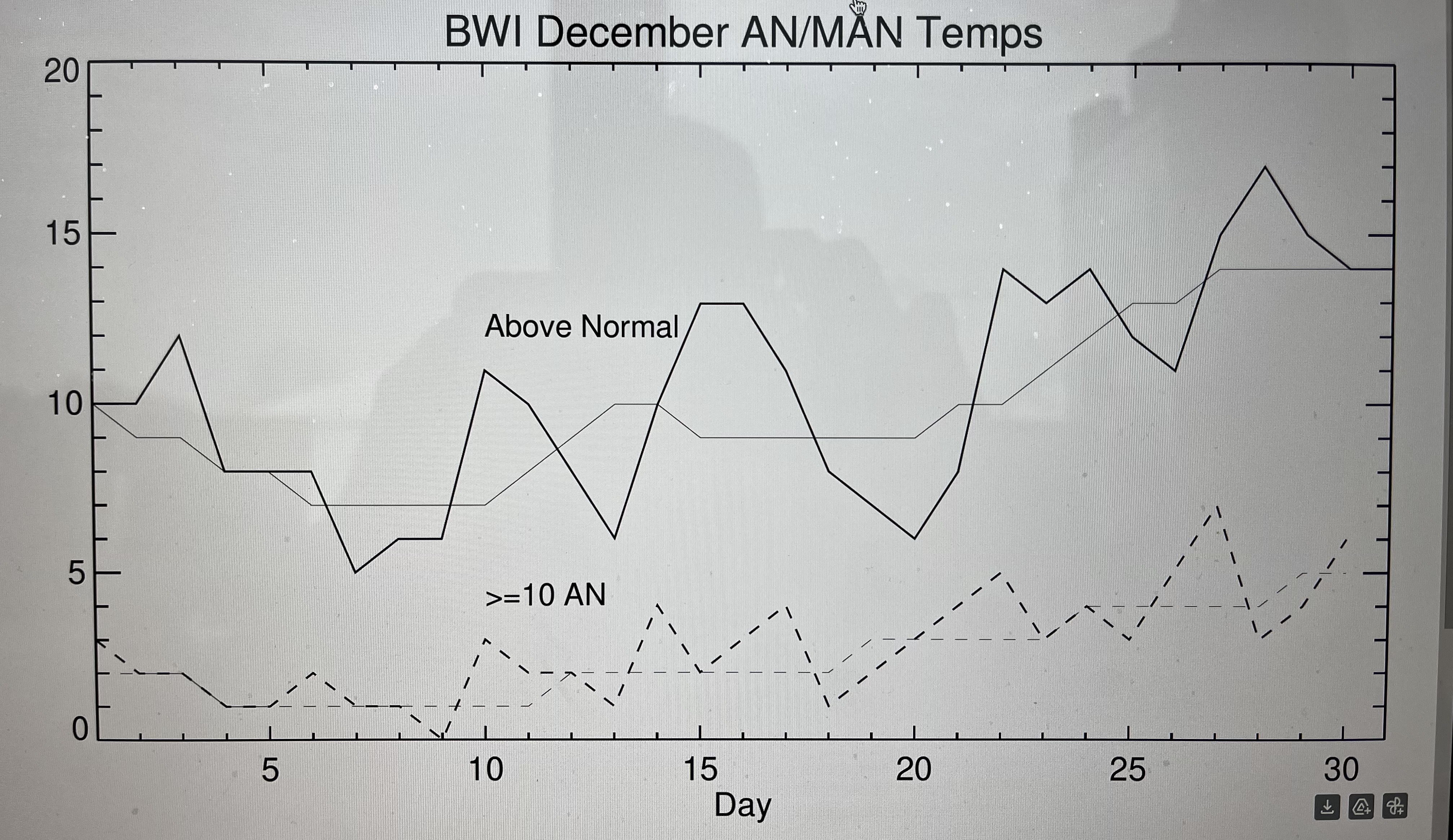
With potentially another Xmas torch staring us in the face, I decided to make a plot to see if it’s been as real as it feels or has been for years. So this plot is BWI above normal and much above normal (>=10F) occurrences from 2005-2024. Thicker lines are the year by year counts for each calendar day and thin lines are smoothed by 7 days. Short answer is yes…and the week after Xmas before new years has been the most torch prone.
-
The warm pool moving eastward would be a good thing for us. Basically puts the background conditions to support the strongest convection (essentially the MJO) in a more favorable position for eastern troughing.
- 827 replies
-
- 13
-

-

-
Last Friday's storm almost disappeared for DC-north within 36 hours? So I don't expect much consistency on a weak vort in fast flow until like 0z Thursday.
-
Just seems weak based on precip. Doesn’t give anybody a ton of love.
-
EPS likes Friday more than Sunday.
-
Euro AI is nothing for Friday outside the mountains. Sunday leans north of us, but dusting for DC, 1” for Baltimore, near 2” along M/D line
-
There it is on 12z gfs. Which is more inevitable? Thanos or Torchmas?
-
GGEM follows icon and Fs us twice
-
Gfs Friday clipper looks great and then falls the F apart, but not before giving VA some much deserved snow!