
strongwxnc
-
Posts
5,611 -
Joined
-
Last visited
Content Type
Profiles
Blogs
Forums
American Weather
Media Demo
Store
Gallery
Posts posted by strongwxnc
-
-

Wall to wall torch starting next week through the end of the run. Doesn't look like a promising start to "Fab" Feb
But we got that snow pack
. -
bottomed out at 12.7
-
 2
2
-
-
14.9 / 5.3
Coldest of the season so far.
-
1
-
-
I love northern Rutherford County.
And I swear, if you wanted to drop off the face of the earth, you could do it in northern Cleveland County.
No doubt! Polkville to Casar in the shadow of south mountain would do it. Or Hollis in Rutherford county.
.-
1
-
-
Down to 31.3. Dropping real fast this afternoon. was 45 at 1:00.

-
2
-
-
Appreciate that strong! I’ll be going live again next few days as we’re getting another 2-3’!
I’m all about it man! Great stuff
.-
 1
1
-
-
1 minute ago, calculus1 said:
730 days since an inch or more of snowfall IMBY: 5.5 inches on January 16, 2022.
I had no idea at that time how long I would have to wait to see any additional significant snowfall IMBY. Still waiting...
It's pretty sad when there are virtually no prior winter weather events to speak of for the past several years on the NWS Raleigh Past Events page:
Yup. Was going through videos and pictures last night from this storm. Four solid days on sledding at the house!
-
1
-
-
We (anyone outside of mountains and south of Virginia) are cooked. Looking at burning 2 more weeks of prime climo with nothing showing besides historical analogs and LR pattern analysis. Seriously, there has been so much time spent over the last month analyzing what will turn out to be 4 below normal days with a warmup for next week.
Don’t forget the snow pack
. -
937 AM EST Tue Jan 16 2024
...SNOWFALL REPORTS...
Location Amount Time/Date Lat/Lon/Elev (ft.)
...North Carolina...
...Avery County...
2 N Banner Elk 15.0 in 0800 PM 01/15 36.19N/81.88W
Beech Mtn 14.0 in 0730 AM 01/16 36.19N/81.87W/5053
1 ENE Sugar Mountain 9.0 in 0640 PM 01/15 36.13N/81.84W
7 NNW Banner Elk 9.0 in 0700 PM 01/15 36.25N/81.91W
1 ENE Banner Elk 6.0 in 0547 PM 01/15 36.17N/81.85W
Newland 6.0 in 0800 PM 01/15 36.09N/81.93W
2 ENE Elk Park 5.5 in 0518 PM 01/15 36.17N/81.94W
2 WSW Banner Elk 2.0 in 0318 PM 01/15 36.15N/81.91W
Plumtree 0.5 W 1.0 in 0700 AM 01/16 36.03N/82.02W/3008...Buncombe County...
Fairview 1.4 WSW T in 0700 AM 01/16 35.51N/82.43W
Weaverville 0.7 SW T in 0700 AM 01/16 35.69N/82.57W
Leicester 2 SE T in 0700 AM 01/16 35.63N/82.68W/2204...Burke County...
Jonas Ridge 1.4 S 0.2 in 0700 AM 01/16 35.95N/81.89W/3635...Caldwell County...
Lenoir 5.9 NNW T in 0700 AM 01/16 35.98N/81.58W/1371...Davie County...
Sheffield 1.9 NE T in 0700 AM 01/16 36.00N/80.66W/914...Haywood County...
Maggie Valley 6.2 in 0930 PM 01/15 35.52N/83.09W
2 N Balsam 5.0 in 0830 AM 01/16 35.46N/83.09W
2 ENE Maggie Valley 3.0 in 0700 AM 01/16 35.54N/83.05W/3450
2 N Balsam 2.5 in 0238 PM 01/15 35.46N/83.09W
Waynesville 2.5 in 0301 PM 01/15 35.48N/83.00W
Waynesville 1.0 NW 1.0 in 0700 AM 01/16 35.49N/83.01W/3039
Waynesville 0.7 ENE T in 0700 AM 01/16 35.49N/82.99W/2679
Waynesville 2.2 SE T in 0730 AM 01/16 35.46N/82.97W/3697...Jackson County...
4 SW Cherokee 2.5 in 0800 PM 01/15 35.43N/83.36W...Madison County...
15 NNE Marshall 5.6 in 0700 AM 01/16 36.01N/82.62W/3104
4 WSW Hot Springs 1.0 in 0557 PM 01/15 35.87N/82.89W
Hot Springs 1.0 in 0700 AM 01/16 35.89N/82.82W/1404
3 SE Spring Creek 0.2 in 0700 AM 01/16 35.77N/82.81W/2866
Marshall T in 0700 AM 01/16 35.80N/82.67W/2000...McDowell County...
Old Fort 4.9 SW T in 0720 AM 01/16 35.58N/82.23W/2679
Marion 3.2 NNW T in 0800 AM 01/16 35.72N/82.03W...Mitchell County...
Buladean 1.3 ESE 8.2 in 0800 AM 01/16 36.10N/82.17W/4029
4 E Bakersville 3.0 in 0900 PM 01/15 36.02N/82.08W
2 SE Bakersville 2.0 in 0800 AM 01/16 35.99N/82.13W/2929
1 SE Buladean 1.0 in 0700 AM 01/16 36.09N/82.17W/3831
Little Switzerland 1.0 W 1.0 in 0800 AM 01/16 35.85N/82.11W/3535...Swain County...
Wesser 1.7 SE 0.9 in 0700 AM 01/16 35.32N/83.56W/2520
...Yancey County...
5 NNE Faust 12.0 in 0800 PM 01/15 35.98N/82.50W
4 SW Burnsville 6.0 in 0650 PM 01/15 35.87N/82.34W
Celo 2 S T in 0700 AM 01/16 35.83N/82.18W/2696-
3
-
1
-
-
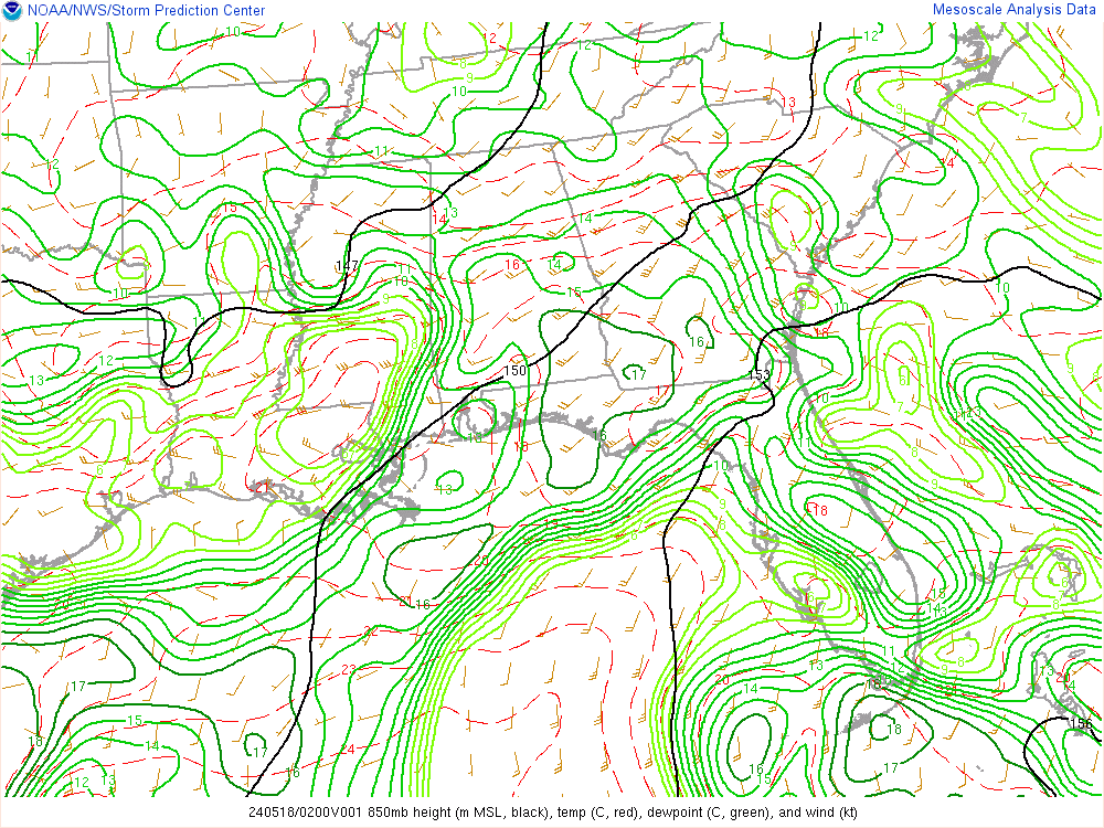
12 ICON pops the SLP in WV when the 6 GFS has it off the coast.

-
2
-
-
9 minutes ago, ncjoaquin said:
Late in a NAM run, but it really picks up on the upslope at the end of the run.
yes it does.
-
1
-
-
The 12 NAM watches the SLP walk out in the sea as it develops on SC coast.
-
@BuffaloWeather has great stream on you tube! He had great long live streams from the system this week.
-
1
-
1
-
-
Nice Jeb Walk @Met1985 !
-
4
-
-
5 minutes ago, ncjoaquin said:
Any of you border counties picking up anything? I have a friend just over the border in TN that says 23 and freezing drizzle. They said it is a skating rink there.
Tight lines at 850.
-
2
-
-
its all going to be ice for the next few days!!
Be careful and have fun!
This was the warmest day in a while starting the school bus at 5:50. That will change
")
-
2
-
-
17 minutes ago, eyewall said:
For Raleigh the last 1 inch or better snowfall was 725 days ago.
729 days for me. 1/16/22
4.5" that day
-
3
-
 4
4
-
-
0700 PM Snow 5 NNE Faust 35.98N 82.50W
01/15/2024 M10.8 inch Yancey NC Public
Heavy snow still falling, accumulating
quickly. Elevation 4360.-
1
-
-
1 minute ago, Maggie Valley Steve said:
We are going to have concrete tomorrow night into Wednesday morning. My forecast low for Wednesday morning is 1. Looking like we will have snow on the ground throughout the upcoming weekend with more snow possible Thursday night into Friday.
Thats the best kind IMO. Well around here it is. Staying power helps with those forecasted cold temps for sure.
-
1
-
-
14 minutes ago, Sw NC weather said:
Looks like yall northern mountain people will be getting smoked over the next hour or so. Temp is down to 33 here hoping the batch from Chattanooga will stay far enough south for me to get a inch or two at the house.
Yes they are! The web cams up that way are fire!
the one at Less Mcrae is so cool.
Congrats folks!!
-
2
-
-
No rain here! Just mid 40’s. Live vicariously through the WebCams.

.-
3
-
-

Some folks getting raked here! Looks like all snow above the line on the CC.
. -
1 hour ago, BuffaloWeather said:
41" storm total here. Winter storm watches in effect for another 1-2'
Thanks for the content man! I always enjoy watching your streams!
-
2
-
-
Dagger!

.-
2
-
 1
1
-
2024 Foothills Thread
in Southeastern States
Posted
Yup. He puts out great content!