
strongwxnc
-
Posts
5,611 -
Joined
-
Last visited
Content Type
Profiles
Blogs
Forums
American Weather
Media Demo
Store
Gallery
Posts posted by strongwxnc
-
-
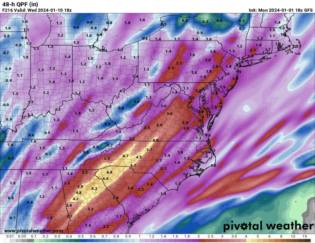
.71 “ of Wasted potential

.
However my new station amount of rain matched my CoCoRaHS gauge exactly!-
 6
6
-
-
5 hours ago, Coach McGuirk said:
4 Rain storms over the next ten days. Then maybe snow?
Maybe after the cutters.
-
picked up .09 so far at 34.5/32.4
WB 32.8
looks like at rain
Winds out of the ENE.
-
1
-
-
Down to 36.5.
.-
1
-
-
39.7/23.0 here
.-
4
-
-
17.6 at the house today.
I upgraded my station for Christmas and added a soil temp sensor. It is at 37.8 this morning.
-
5
-
-
I will take it!
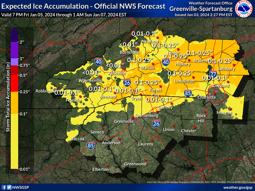
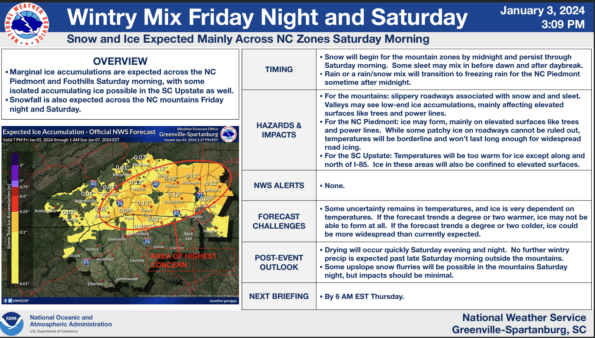
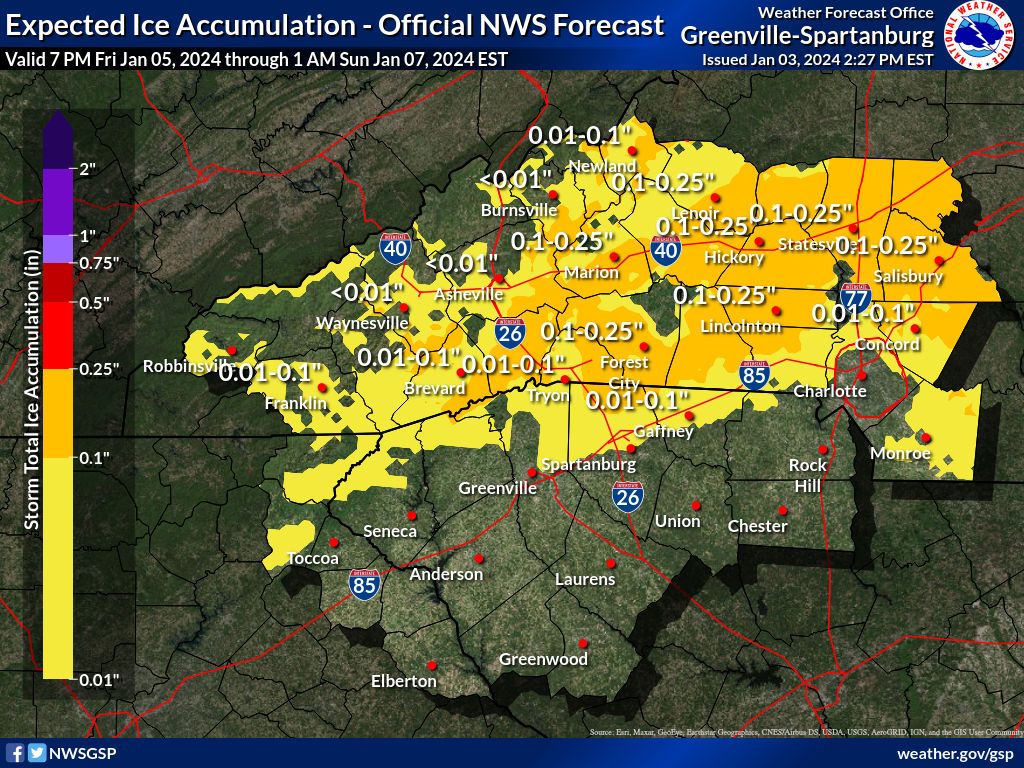
https://www.weather.gov/media/gsp/YouTube/brief.pdf
...WINTER WEATHER ADVISORY IN EFFECT FROM 1 AM TO 1 PM EST
SATURDAY...

* WHAT...Mixed precipitation expected. Total snow accumulations
  of up to one inch and ice accumulations of up to two tenths of
  an inch.

* WHERE...Portions of the foothills of North Carolina.
-
1
-
-
4 hours ago, BretWx said:
Unrelated, but approaching 13 years on here! Feel like I know y'all but don't at the same time. It has been fun my friends.

Yup, that was when Eastern WX moved over to American WX. I started when Eastern WX got going around 01-02 or so when I was at APP.
-
4
-
-
Decision Support Briefing:
-
2
-
-
Sitting in the .1–.25
.
Just a little bit of everything-
1
-
-
7 minutes ago, BooneWX said:
I need to print some “I hate the Pacific” t-shirts. I’d make a killing with our group and the Mid Atlantic crew.
When the west coast we toast for sure.
-
1
-
-
I was really hoping that i could track a good storm during our Christmas break from school. Nope.
I swear If i hear, "the long term looks good" one more time, Im going to burn it down. LOL
Going back to my old rule of thumb of, when he shows shows 6 hours out I'll bite.
..I feel better now...
-
3
-
 1
1
-
-
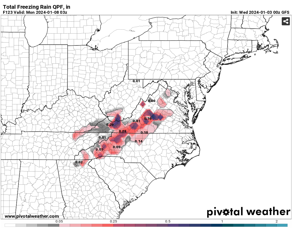
GFS ZR Map, seeing some 0.25 down to ~ shelby, nc

Canadian says lights out
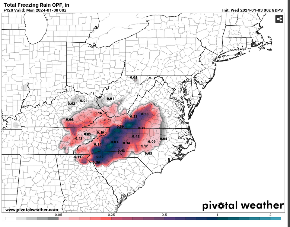
Poling 1” totals in Rutherford. Dang
.-
1
-
-
Perfect. That's exactly what I was looking for!
TW
I lived in sugar grove my last year at app in 03/04. Got 19” in December on 03 that year. Nice area!
.-
1
-
-
Just now, Met1985 said:
The third system on the gfs may bring some flooding....

Sent from my SM-G998U using Tapatalk
Nothing says winter like flooding rains.. lol
-
2
-
 2
2
-
-
I’ll take that man cake down here in Rutherford county!

.-
2
-
-
23 minutes ago, SnowDawg said:
Just got NAM'd!! Too bad it's the NAM at range lol.
Most likely on an island but Im heading to that island for now
-
3
-
-
The cmc has what we want.

Sent from my SM-G998U using Tapatalk
Big time !
.-
2
-
-
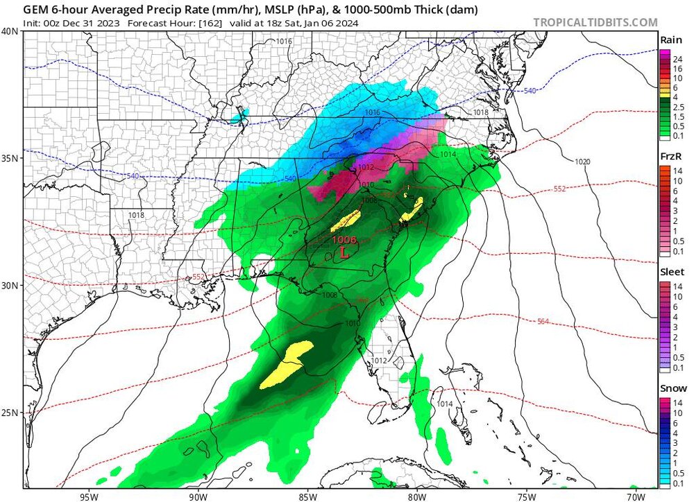
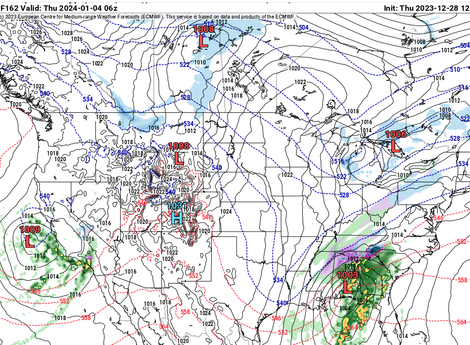
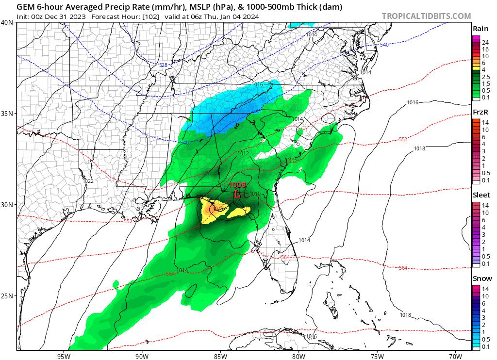
7 hours ago, Tyler Penland said:
0z GFS is a step in the right direction for Wednesday night. I could see this sneak into a light event if things trend a little stronger with the low.
Even more with the 006 Z run of the GFS.
Over night discussion from gsp-1:30am:
The GFS and EC have maintained decent
run-to-run consistency, with low tracks far enough south that only
our southernmost zones fall under the precip shield. The GDPS
has also shifted the low farther south, but features a sharper
thermal gradient and slightly slower trough, so it is more expansive
with precip across the Carolinas in a somewhat more Miller B-type
pattern. It had been the wettest but warmest model 24 hours ago,
but now its sfc temps/wet-bulbs make it the coldest model despite
having all the precip. A few members of all three of these models'
ensembles depict a wetter solution, but as we typically see, these
members are among the warmest during the passage of the low. -
NCZ048-051-052-058-059-062-291700-
Madison-Swain-Haywood-Graham-Northern Jackson-Macon-
Including the cities of Faust, Mars Hill, Marshall, Walnut,
Allenstand, Hot Springs, Luck, Alarka, Almond, Bryson City,
Luada, Wesser, Waynesville, Waterville, Canton, Cruso,
Cove Creek, Robbinsville, Stecoah, Cullowhee, Tuckasegee, Sylva,
Franklin, Rainbow Springs, Kyle, and Highlands
928 AM EST Fri Dec 29 2023
...LIGHT SNOW THIS MORNING OVER THE SMOKIES...
An area of light precipitation seen on radar this morning over
east Tennessee will move slowly eastward over the mountains of
North Carolina along the Tennessee border. Most of the
precipitation will fall as light snow through noon because of the
cold temperatures over the mountains. Some parts of the Smokies
could get up to an inch of accumulation, particularly above 3000
feet. A dusting will also be possible across valley locations,
mainly along and west of a line from Franklin to Sylva,
Waynesville, and Marshall. Be careful while driving on untreated
roads this morning and watch out for slick spots.-
2
-
-
European with a little something for next week. Temps need a little help.
Nice look for now.
.-
1
-
-
Updated my PWS from a ambient 2902-b to the ambient ws-2000 yesterday.
The 2902 ran strong the last five years before having small issues. But still worked well!
I was looking for the ability to add more sensors to my home.
Looking forward to calibrating it over the next few weeks.
38.5/38.2
.-
3
-
-
2.81” so far. Looking to pick up a lot more this morning.
Saw some lightning a few minutes ago.
54.1/53.0
.-
3
-
-
The sound of steady rain hitting the metal roof is easing the soul tonight. Been battling either the flu or strep for 2 days. Hope yall had a better holiday than I did
 . Merry Christmas!
Same here man! Been dealing with a fever since Thursday. Feel better
Merry Christmas
.-
3
-


Southeast Sanitarium - Winter 23/24 Edition
in Southeastern States
Posted
1.03” of rain in January will always piss me off. lol
Even though this was going to be a non event, come one.
Wasted potential
.