
wxmanmitch
-
Posts
2,087 -
Joined
-
Last visited
Content Type
Profiles
Blogs
Forums
American Weather
Media Demo
Store
Gallery
Everything posted by wxmanmitch
-
I had 11.0" on the front end Saturday AM.
-
3.0" new in the past 24 hours. I've now had 13" of upslope since Saturday afternoon, depth is 22". 74.1" for the the season. Not bad at all considering where we were a week ago.
-

January 16 2021 - Inland runner Rain/Snow/Wind
wxmanmitch replied to Baroclinic Zone's topic in New England
I've driven the National Forest roads up to Somerset Reservoir and there are some off the grid homesteaders up there that are about 2,200-2,300' elevation. That place has the ultimate weenie spot for snow, but no, I don't think I could live there, lol. I need power and Internet. But with solar power and this soon to be released low orbit, low latency satellite Internet from SpaceX called StarLink who's to say more people won't be able to move to places like that. That whole area is basically a 2,000-2,500' basin that catches snow and retains it. I don't know what that area averages, but 200" per year isn't far fetched at all. -
January 16 2021 - Inland runner Rain/Snow/Wind
wxmanmitch replied to Baroclinic Zone's topic in New England
It does. The base of Mt. Snow is at 1,900' at doesn't get as much of the upslope on W to NW flow as Woodford or my location do. -
January 16 2021 - Inland runner Rain/Snow/Wind
wxmanmitch replied to Baroclinic Zone's topic in New England
I'm actually about 5 miles to the SE of Woodford center, but on the same ridge at about the same elevation. The person who measures there is on the east side of the town at exactly my longitude (4.5 miles due north of my spot). They are sometimes too high while other times reasonable. Woodford reported a 24" two day total yesterday while I had 17", which seems like a rather large difference given the small distance and roughly same elevation (2300' vs. my 2,230'). It's conceivable that they may have had a little more than I did (perhaps 18 to 20") but I find it somewhat hard to believe that there was that large of a difference without some type of mesoscale snow band evident on radar to account for it. But without going up there to poke around and measure myself, I will give them the benefit of the doubt since it is an extremely snowy place. Anyway, enough of scrutinizing Woodford's total since snow measuring is not an exact science. I had another 3.1" from upslope overnight last night and into today. Three day total is now 20.1" with a depth of 20.5". -
January 16 2021 - Inland runner Rain/Snow/Wind
wxmanmitch replied to Baroclinic Zone's topic in New England
As best I can tell, 6.0" from the backside and upslope so the storm total is 17". It's very windy so there's lots of blowing and drifting. The measurement is an average of several. 0.56" of liquid. The 24" report from Woodford seems a bit high IMO. -
January 16 2021 - Inland runner Rain/Snow/Wind
wxmanmitch replied to Baroclinic Zone's topic in New England
1.54" of liquid in my 11.0" of snow yielding a 7.14 to 1 ratio. This is really meaty stuff! It has compacted down to about 10" since I did get a little above freezing. Meso models are dumping anywhere from 0.5" to over 1" of liquid equivalent in upslope snow over the next 48 hours, so we'll see what that results in. -
January 16 2021 - Inland runner Rain/Snow/Wind
wxmanmitch replied to Baroclinic Zone's topic in New England
11.0" total for the front end. Getting some light rain showers now at 33° F in the dry slot. The sun even popped out briefly. Woodford just to my north reported 16" at 9 AM, I had ~10" then. Seems a little high given that we're only ~5 miles apart and 70' difference in elevation. -
January 16 2021 - Inland runner Rain/Snow/Wind
wxmanmitch replied to Baroclinic Zone's topic in New England
10" even as of 10 minutes ago. Dry slot looks to be filling in a bit with more showery precipitation. We'll see if I stay all snow or mix when it arrives. -
January 16 2021 - Inland runner Rain/Snow/Wind
wxmanmitch replied to Baroclinic Zone's topic in New England
Not yet, I'll do once the front end is over. I'm guessing this snow is about 10:1 so far. It's dense, but not super wet since I'm below freezing up here. -
January 16 2021 - Inland runner Rain/Snow/Wind
wxmanmitch replied to Baroclinic Zone's topic in New England
Moderate to heavy snow, 30.0° F. 8.7" as of 15 minutes ago, so probably about 9" now. Grid power is down, but thankfully I have backup. I'm guessing I'll finish the front end with 12-13". -
January 16 2021 - Inland runner Rain/Snow/Wind
wxmanmitch replied to Baroclinic Zone's topic in New England
28.8° F with freezing drizzle. Not too concerned about it as the column is likely below freezing but not quite cold enough for nucleation in the SE flow upslope stratus deck. Getting increasingly breezy too. -
January 16 2021 - Inland runner Rain/Snow/Wind
wxmanmitch replied to Baroclinic Zone's topic in New England
Woodford, VT at 2.4K looks great! -
January 16 2021 - Inland runner Rain/Snow/Wind
wxmanmitch replied to Baroclinic Zone's topic in New England
I like where I am for this event. NAM and GFS both pumping out 2-2.5" of QPF here the next 2 to 3 days. How much of it falls as solid vs. liquid will make a big difference with respect to snowfall. My gut tells me the front end is a 6-8" blue bomb here that turns to some light rain or drizzle in the dry slot tomorrow followed by several more inches of upslope on the backside tomorrow night into Sunday. As such, a foot plus is not out of the question here even if we do get a little rain tomorrow after the heavier precipitation moves out. -
New Jersey tags are plentiful as well, particularly up around Wilmington and Mt. Snow. They're the worst drivers though...
-
I like my location in southern Vermont. Good snow and not terribly far from the big cities: 1.5 hours to Albany, 2 to Hartford, 3 to Boston, and 4 to NYC. Plus, all of the cultural and outdoor recreational options of the Berkshires and southern Vermont are nearby. I definitely tend to feel this part of New England is sometimes overlooked and unappreciated, especially by the Boston crowd. Connecticut and NYC area people are well represented here though.
-
That 131.0" was for the 2020 calendar year. My 2019-20 snowfall total is in my signature.
-
My 2020 weather stats: Total precipitation: 58.32" Total Snowfall: 131.0" Average Temperature: 43.6° F Lowest Temperature: -7.9° F on 2/15 Highest Temperature: 84.8° F on 7/19 I'm amazed at how high my precipitation total is given that Bennington just over the hill about 12 miles away had only 36.94" and Pittsfield, MA about 30 miles to my SSW had 37.41". This total is from a Stratus rain gauge and not from my Davis VP2 tipping bucket gauge.
-
2.0" of icy crap-o-rama here with 0.93 liquid equivalent. 0.2" of ice accretion after the 2" of snow and sleet. I also had about 0.2" of ice accretion two nights ago, so there was 0.4" total glaze. Fortunately only some twigs and small branches came down and no power issues. Glad to see a decent little 5-8" event for the north country since they largely missed out on the big storm two weeks ago.
-
I sure do! I "measured" 45 inches in that event, but have since changed my measuring protocols to be consistent with CoCoRaHS methodology since I was clearing the board too much. I probably had somewhere in the 36-40" range. I clear the board once every 24 hours now.
-
23.0" with 2.11" of liquid the final here. I was surprised there was that much liquid in the snow given how cold the storm was. Maybe I'll core it again tomorrow to confirm that liquid equivalency...
-
Yup, and Okemo too. Seeing some reports of around 36" up around Ludlow, VT.
-
Wow! Looks like 18" or so here. Haven't gone out to measure yet. That death band wound up about 20-30 miles further north than modeled. Amazing storm.
-
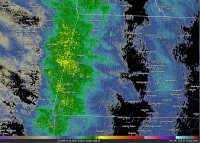
I literally have goosebumps right now after seeing the RDPS (RGEM) and the radar. Death band incoming and I may very well be very close to or under the pivot point. It's already pounding snow, although flakes are small to medium. 9.4° F.
-
December 5-6, 2020 Storm Observations and Nowcast
wxmanmitch replied to Baroclinic Zone's topic in New England
4.0" final here. Wind is absolutely howling just above the surface with the occasional gust mixing down. Snow is blowing around all over the place making measuring difficult. 25.5° F.
