Jump to content

snywx

Members
  • Posts

    10,049
  • Joined

  • Last visited

Everything posted by snywx
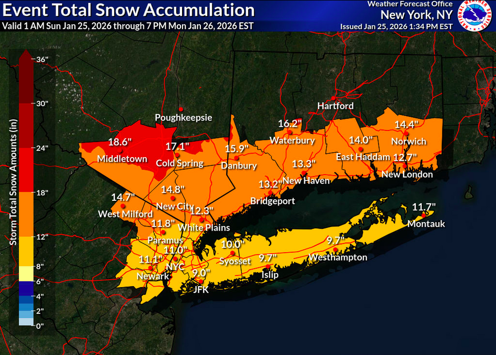
  1. My strongest winds were after the storm as well
  2. About 1” or so.. plenty of bare spots
  3. Interesting.. I was just on the road and everything seemed to be operating as normal. Only thing I can think of is teachers who live in effected areas may be having trouble coming in
  4. So the kids have a 2 hr delay from some rain in january lol.. Gotta love it. Snowpack is still quite healthy here Temp 41°
  5. 6z GFS caught on to idea of a coastal
  6. 31 here Snow picking up in intensity
  7. 000 NOUS41 KOKX 071303 PNSOKX CTZ005>012-NJZ002-004-006-103>108-NYZ067>075-078>081-176>179-080103- Public Information Statement National Weather Service New York NY 803 AM EST Sun Jan 7 2024 ...LATEST SNOWFALL REPORTS... Location Amount Time/Date Provider ...Connecticut... ...Fairfield County... 4 SSE Sherman 6.0 in 0701 AM 01/07 Trained Spotter Greenwich 4.5 in 1200 AM 01/07 Public Redding 4.0 in 1209 AM 01/07 Public Ridgefield 2.4 NNE 3.9 in 0700 AM 01/07 COCORAHS Stamford 3.5 in 1022 PM 01/06 Public 2 S New Canaan 3.0 in 0850 PM 01/06 Public 1 SE Wilton 3.0 in 1016 PM 01/06 Public 1 NNW Rowayton 3.0 in 1138 PM 01/06 COCORAHS Bridgeport Airport 3.0 in 0700 AM 01/07 Official NWS Obs Norwalk 3.0 in 0700 AM 01/07 COCORAHS Norwalk 2.8 in 1100 PM 01/06 Public Bethel 2.5 in 0620 AM 01/07 Emergency Mngr 3 E Easton 2.4 in 1140 PM 01/06 Public 3 WSW Shelton 2.1 in 0710 AM 01/07 Trained Spotter Stratford 2.0 in 0600 AM 01/07 COCORAHS Newtown 5.3 S 1.9 in 0700 AM 01/07 COCORAHS Stratford 1.8 in 1028 PM 01/06 Trained Spotter Ridgefield 1.8 in 0630 AM 01/07 COCORAHS Newtown 1.3 in 1045 PM 01/06 Public Trumbull 2.6 SSE 1.3 in 0730 AM 01/07 COCORAHS ...Middlesex County... Durham 3.2 in 0700 AM 01/07 COCORAHS Middlefield 1.4 W 2.5 in 0600 AM 01/07 COCORAHS Moodus 0.7 SSW 1.7 in 0700 AM 01/07 COCORAHS Westbrook 0.8 in 0742 AM 01/07 Trained Spotter Westbrook 0.5 in 0942 PM 01/06 Trained Spotter ...New Haven County... 1 E North Haven 3.0 in 1215 AM 01/07 Trained Spotter Naugatuck 3.0 in 0700 AM 01/07 COCORAHS Guilford 2.5 in 0645 AM 01/07 CO-OP Observer Seymour 1.2 WSW 2.5 in 0700 AM 01/07 COCORAHS Wallingford 2.0 in 1200 AM 01/07 Trained Spotter Milford 1.2 in 0910 PM 01/06 Public Madison 0.7 in 0700 AM 01/07 Public Meriden 0.5 in 0915 PM 01/06 Trained Spotter East Haven 0.3 in 0915 PM 01/06 Trained Spotter ...New London County... Norwich 2.7 in 0600 AM 01/07 COCORAHS Norwich 2.0 in 0700 AM 01/07 COOP Waterford 0.8 in 0700 AM 01/07 COCORAHS Preston 0.7 in 0730 AM 01/07 COCORAHS Niantic 0.5 in 0600 AM 01/07 COCORAHS Uncasville 0.5 in 0700 AM 01/07 COCORAHS Niantic 0.3 in 0915 PM 01/06 Trained Spotter Old Lyme 0.3 in 0700 AM 01/07 COCORAHS ...New Jersey... ...Bergen County... 1 N Franklin Lakes 5.7 in 1030 PM 01/06 Trained Spotter Franklin Lakes 4.0 in 0815 PM 01/06 Trained Spotter Glen Rock 4.0 in 0934 PM 01/06 Trained Spotter Ridgewood 3.7 in 1123 PM 01/06 Public Fair Lawn 3.4 in 1000 PM 01/06 Trained Spotter Westwood 2.8 in 0830 PM 01/06 Trained Spotter River Vale 2.8 in 0900 PM 01/06 Trained Spotter Bergenfield 1.0 in 0725 PM 01/06 Trained Spotter East Rutherford 0.5 in 0800 PM 01/06 Trained Spotter ...Essex County... North Caldwell 4.4 in 0535 AM 01/07 Public Livingston 3.6 in 1000 PM 01/06 Public West Orange 3.5 in 1130 PM 01/06 Public ...Hudson County... Harrison 1.0 in 0700 AM 01/07 COOP ...Passaic County... Totowa 5.0 in 0150 AM 01/07 Public Wayne 3.8 in 0730 AM 01/07 Trained Spotter ...Union County... Plainfield 2.2 in 0820 PM 01/06 Trained Spotter New Providence 1.7 in 0815 PM 01/06 Public Linden 0.7 in 0630 PM 01/06 Public Newark Airport 0.4 in 0700 AM 01/07 Official NWS Obs ...New York... ...Nassau County... Manhasset Hills 0.5 in 0736 PM 01/06 COCORAHS Plainview 0.3 in 0847 PM 01/06 Public ...New York (Manhattan) County... Central Park 0.2 in 0700 AM 01/07 Official NWS Obs ...Orange County... 2 SE Port Jervis 13.1 in 0630 AM 01/07 COCORAHS 3 NNE Unionville 12.4 in 1253 AM 01/07 Public Middletown 11.8 in 1215 AM 01/07 Fire Dept/Rescue Montgomery 11.0 in 1130 PM 01/06 Public 3 SSW Pine Bush 9.5 in 1201 AM 01/07 Public Salisbury Mills 9.2 in 0500 AM 01/07 Trained Spotter Newburgh 9.0 in 1125 PM 01/06 Public 2 SSW Stewart Airport 9.0 in 1205 AM 01/07 Public 1 WNW Monroe 8.0 in 1230 AM 01/07 Trained Spotter 2 E Highland Mills 7.5 in 1212 AM 01/07 Public Warwick 7.0 in 1030 PM 01/06 Public Chester 5.5 in 1015 PM 01/06 COCORAHS Highland Mills 4.8 in 1026 PM 01/06 Public Firthcliffe 2.9 in 0954 PM 01/06 Public West Point 2.5 in 0940 PM 01/06 Trained Spotter ...Putnam County... Cold Spring 6.5 in 0700 AM 01/07 COCORAHS Nelsonville 0.3 S 6.0 in 0700 AM 01/07 COCORAHS Cold Spring 6.0 in 0700 AM 01/07 Cocorahs ...Queens County... NYC/La Guardia 0.3 in 0700 AM 01/07 Official NWS Obs Little Neck 0.3 SE 0.3 in 0700 AM 01/07 COCORAHS NYC/JFK 0.1 in 0700 AM 01/07 Official NWS Obs Howard Beach T in 0700 AM 01/07 COCORAHS ...Richmond County... Westerleigh 0.2 in 0545 PM 01/06 Public ...Rockland County... Stony Point 4.0 in 0700 AM 01/07 COCORAHS Blauvelt 3.5 in 0922 PM 01/06 Public New City 3.0 in 1135 PM 01/06 Trained Spotter 2 W Buchanan 3.0 in 0720 AM 01/07 Public ...Suffolk County... Commack 1.3 SW 0.4 in 0700 AM 01/07 COCORAHS Commack 0.3 in 0800 PM 01/06 Public Ridge T in 1159 PM 01/06 COCORAHS Upton T in 0700 AM 01/07 Official NWS Obs Islip Airport T in 0700 AM 01/07 Official NWS Obs Orient Point T in 0700 AM 01/07 COOP ...Westchester County... Shrub Oak 4.0 in 0600 AM 01/07 COOP 2 WNW Jefferson Valley 4.0 in 0600 AM 01/07 CO-OP Observer Hartsdale 3.5 in 1040 PM 01/06 Trained Spotter Croton-on-Hudson 2.9 in 0945 PM 01/06 Public White Plains 2.8 in 1037 PM 01/06 Trained Spotter Ossining 2.5 in 0845 PM 01/06 Public &&
  8. Some of the heaviest snow I've ever seen. Dropped 9" in just over 2 hrs. 12.2" otg here
  9. That was impressive! 9" in just over 2 hrs
×
×
  • Create New...