Tony Sisk
-
Posts
439 -
Joined
-
Last visited
Content Type
Profiles
Blogs
Forums
American Weather
Media Demo
Store
Gallery
Everything posted by Tony Sisk
-
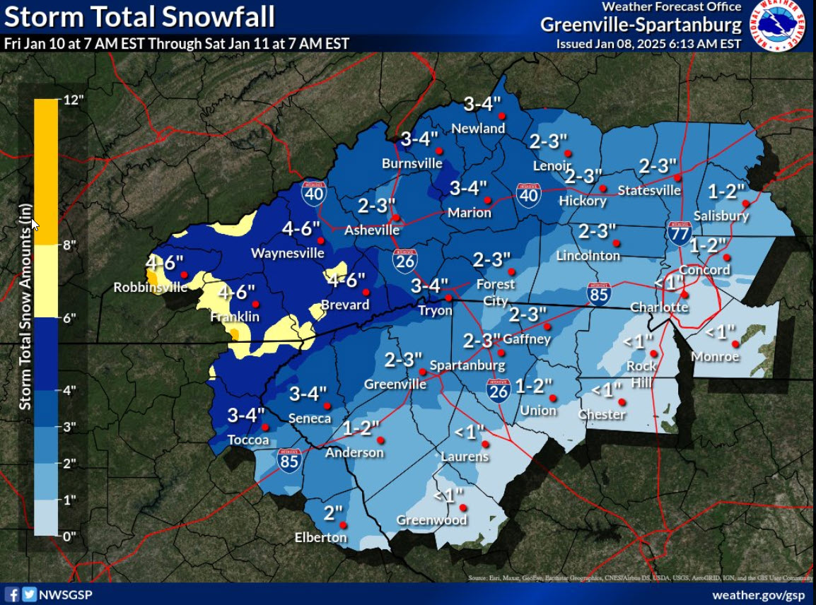
 Initially, most precipitation will fall as snow. Temps will have dropped well below freezing across the area Friday morning, and the mid/upper levels will be saturated enough that nucleation should not be an issue. So, whatever falls will fall as snow...and although a deep dry layer will be in place as precipitation begins, guidance depicts such strong isentropic ascent that it won`t take more than 1-2 hours for this layer to saturate...allowing for things to pretty quickly evolve from dry conditions, to flurries, to accumulating snow during the late morning or early afternoon. Temperatures should max out before the normal diurnal max, peaking at basically however warm it can get before precipitation begins and temps begin wet-bulbing down. This looks like it may take place as early as the 9am-12pm window, at least for the western half of the CWA, where things will ramp up sooner. The details beyond this point, however, are murkier. During the evening and overnight, WAA will continue, and some form of changeover from all-snow to wintry mix appears likely. The most recent 12z cycle of operational guidance has sped up its handling of low-level isentropic ascent, but in response to a more southward storm track, the resulting warm nose is also higher - as high as 700mb per the latest NAM - with a deeper subfreezing layer at the surface. Accordingly, calibrated sleet probabilities have increased at the expense of lower snow and freezing rain probs...somewhat reducing overall ice accumulations despite the robust warm nose. Unfortunately, there`s still a lot of room for error, and a lot of time for the forecast to change. If low-level profiles get even a tiny bit warmer, it`ll mean less sleet and more ice. If the warm nose gets stronger...less snow, more ice. If the system speeds up, QPF, which continues exhibit a lot of spread among ensembles, could change, which would alter both snow and ice totals. It looks increasingly likely, though, that the Upstate won`t escape at least a small amount of ice, and that zones as far north as I-40 will be under the gun for some sleet. Dreams of an all-snow forecast? Quashed.
 -
Winter Storm Watch now in for the Upstate of SC Winter Storm Watch
-
Really curious/surprised as to why GSP NWS did not extend the Watch criteria to the Upstate of SC in the 11am update. Do you think it is coming at 4pm?
-
Could not have drawn it up any better
-
wonder why northern SC is generally not treated the same as northern MS/AL/GA?
-
I'd say more like 4-6" Asheville. We should start seeing "first call" snow maps this afternoon for the evening newscasts. 2-4" will be along and north of 85 in the upstate. (My guess) For sure Warning criteria for our neck of the woods.
-
#ClimateChangesEveryDay
-
and it's been that way for the entire 58 years of my life as well as, as long as records have been kept.
-
Bryson City - Smokey Mtn Railway
-
Live look at Waynesville
-
you do realize, it's all your fault!
-
my Mama used to tell me to never eat from the first snowfall. I mean, I didn't realize then that we didn't have many options. Sometimes, there is no snowfall....you better take advantage on all snowfalls!
-
good stuff....the system literally exploded right over the upstate of SC
-
January 20-22 “bring the mojo” winter storm threat
Tony Sisk replied to lilj4425's topic in Southeastern States
game over as being, out of play...I think is what you are saying. -
January 20-22 “bring the mojo” winter storm threat
Tony Sisk replied to lilj4425's topic in Southeastern States
it was Parella -
January 20-22 “bring the mojo” winter storm threat
Tony Sisk replied to lilj4425's topic in Southeastern States
Well, it was a twitter post he linked. We all know twitter can be a ceaspool. But seriously, I consider this more of a family setting, and should be treated as such. Thanks for speaking up gman!! -
January 20-22 “bring the mojo” winter storm threat
Tony Sisk replied to lilj4425's topic in Southeastern States
Where is burrell2? I don’t believe I’ve seen his name in this thread. He was fantastic with the last storm! -
Winter Storm Izzy Obs Thread
Tony Sisk replied to Prismshine Productions's topic in Southeastern States
A good 7” here in Taylors near East Lee Rd. Took two measurements on less disturbed area I could find in the open. Flat table surfaces. There are “drifts” a good foot deep in wind driven areas. -
Winter Storm Izzy Obs Thread
Tony Sisk replied to Prismshine Productions's topic in Southeastern States
Surface low is leaving the upper low behind. It’s been a great show! -
Winter Storm Izzy Obs Thread
Tony Sisk replied to Prismshine Productions's topic in Southeastern States
Best we have had in years…thanks family! -
Winter Storm Izzy Obs Thread
Tony Sisk replied to Prismshine Productions's topic in Southeastern States
I was just looking at the mountain cams, hardly no snow in Bryson City. Makes no sense. -
Winter Storm Izzy Obs Thread
Tony Sisk replied to Prismshine Productions's topic in Southeastern States
This has been pretty much perfect for the I-85 corridor in SC. The heavy precip that fell from 2:00am to 7:00am was ALL Snow. The precip that is falling now is very light, but a mix bag. Not sure how much wrap around snow we will get…but it appears the nasty stuff is going to be light. -
Winter Storm Izzy Obs Thread
Tony Sisk replied to Prismshine Productions's topic in Southeastern States
I heard anywhere from 4-7” in Taylors. I did 3 different measurements of 5”. Matter of fact, had to go on the roof to clear the satellite dish. I thought I was on the bottom step, but i5 was the 3rd step…I busted my tail…then made a snow angel and laughed at myself! -
Burrell never wavered on what he expected. It happened exactly as predicted. GSP and Justus reacted, which is unusual.