

weatherwiz
-
Posts
76,424 -
Joined
-
Last visited
Content Type
Profiles
Blogs
Forums
American Weather
Media Demo
Store
Gallery
Posts posted by weatherwiz
-
-
EWB.
The best part of big snow events...is looking at omega values on buflit. This also shows there is going to be serious subsidence somewhere. Cross sections are going to display this super well

-
 1
1
-
-
Just now, Zeus said:
You've got three more 12z's to go before you see a flake. Let us reflect on this, and permit the comfort that it brings.
Very poetic. I feel better already
-
This pisses me off..any other day 12z GFS bufkit is out by now. ughhhhhhhhhhhhhhhhhhh

-
May see legit thunderstorms out on the Cape. Severe thunderstorms containing heavy snow


-
-
Just now, 40/70 Benchmark said:
I hope your relationship survives this storm....weenie marriages are going to be tested all throughout NE. Glad wifey still away lol
12-24''+ of snow > relationship

-
 2
2
-
-
I know it's early but I can wait to check out some 12z GFS bufkit profiles. Betting we see like -60 to -70 units of omega popping...hopefully well into the DGZ
-
 1
1
-
-
1 minute ago, 40/70 Benchmark said:
Hopefully the H5 low isn't 200 mi wide like Boxing day.
Agreed...and IIRC that was something that was overlooked heading into the storm. There was so much focus on what looked great that many flags were missed.
-
Just now, 40/70 Benchmark said:
There going to big ranges.....someone within 15 miles of me will be doing kegs stands in 37, while I bitch about 15".
Absolutely...that's pretty much a given I think. Some are going to get screwed compared to some around them.
-
1 minute ago, Go Kart Mozart said:
If you look closely, does this imply a frontogen band near the NY CT border?
It's actually not uncommon to see two bands unfold in major storms like this. And they can be a forecast killer (in both directions) b/c you can get some serious subsidence between the two. In some cases the two bands will even consolidate and all hell just breaks lose under it
-
 1
1
-
1
-
-
The degree of dynamic cooling is jaw dropping on this. The distance between like +11C to +12C and -13C to -14C (talking 850 temps) is very small.
-
1
-
-
5 minutes ago, dryslot said:
Pwats are going to be high.
Historic snowfall rates are probable if this verified.
-
1
-
-
Looks like +11C or s at the core
 The moisture inflow into the CCB is going to be ridiculous

-
5
-
-
5 minutes ago, CT Rain said:
Beast mode. Scooter can stop is complaining... but not quite perfect for us in CT lol
Super close. May be pretty solid eastern CT. 700 pops just a bit too late for western/central CT to probably get into the CCB goods

-
1
-
-
1 minute ago, 40/70 Benchmark said:
Faster than 00z EURO is pretty unlikely,
I would agree with that.
-
2 minutes ago, 40/70 Benchmark said:
The NAM had no other direction to hedge, it was burying it into Hawaii last night.
Faster timing/scenario is plausible at this time.
-
2 minutes ago, jbenedet said:
Yea and it would come in much faster. 12 hrs+. Would be a Friday/Saturday impact, rather than Sat/Sunday
I could see that happening. Seems like more times than not we see timing sped up as we get closer...especially with no block in place. You can see the NAM probably hedging in that direction.
-
3 minutes ago, jbenedet said:
The western Ridge keeps trending further west with time on guidance at around hr 72. An axis over western Washington state without any blocking in eastern Canada is typically a recipe for a cutter or very tucked in track. If the northern stream and southern stream cleanly phase early—around hr 72, this comes much further west than current guidance consensus—there’s plenty of “room” in terms of wave spacing.
Not only a bit more west but also stronger (higher heights pushing slightly more north.
-
1 minute ago, ORH_wxman said:
NAM would prob be more than a light event....it is more amped than the 06z GFS was at 90h.
Looks much better (favorable) with the ridging into the West and is slightly further west with the trough axis into the Gulf Coast. Would probably continue to see amplification too based on the jet. Still have a developing jet steak on the western side of the trough axis.
-
Hopefully some of the recent changes in direction are not a product of starting to get better sampling (which would be not so good news) but the notable differences in the structures of just about everything...ridging in the West, evolution of the southern shortwave, the trough, and also the ULJ across the region is a bit concerning right now. We're not talking about subtle changes either.
-
1
-
 1
1
-
-
4 minutes ago, CT Valley Dryslot said:
NAM can't even give a consistent 24hr forecast.
It moved the kicker vort 150mi east into NM at hour 27 compared to 6z!
The differences in short-term between the NAM/GFS have been insane...and not just here but throughout the country. Finally there seems to be some agreement on that but even yesterday morning the NAM/GFS were worlds apart on that system. It's been that way with just about every weather system this winter across the country.
-
1
-
-
4 minutes ago, JC-CT said:
I was asking about the domain, not forecast time.
both the shortwaves of interest are within the domain
-
2 minutes ago, JC-CT said:
Is it even inside the NAMs grid range right now
Just now, CT Valley Dryslot said:I don't believe so. And it won't be for a few days.
Not the storm but watching how the NAM starts to handle the evolution of the pattern across the eastern Pacific and western U.S. is certainly in range.
When there is storm potential we spend so much time focusing on the U.S. domain when in reality the domain of focus should be shifted much farther west to incorporate the Pacific. For example, models have been really been building the ridging into the western U.S. moving into Wednesday...well the processes and evolution of that is really starting over the Pacific now so understanding how the models are handling what's occurring over the Pacific may yield big clues.
-
1
-
-
Just now, JC-CT said:
It happens between hours 39 and 54
It's insane...not just differences with the strength of the ridge but orientation too. The pattern over the Pacific is quite chaotic. Probably need to get that resolved before anything else


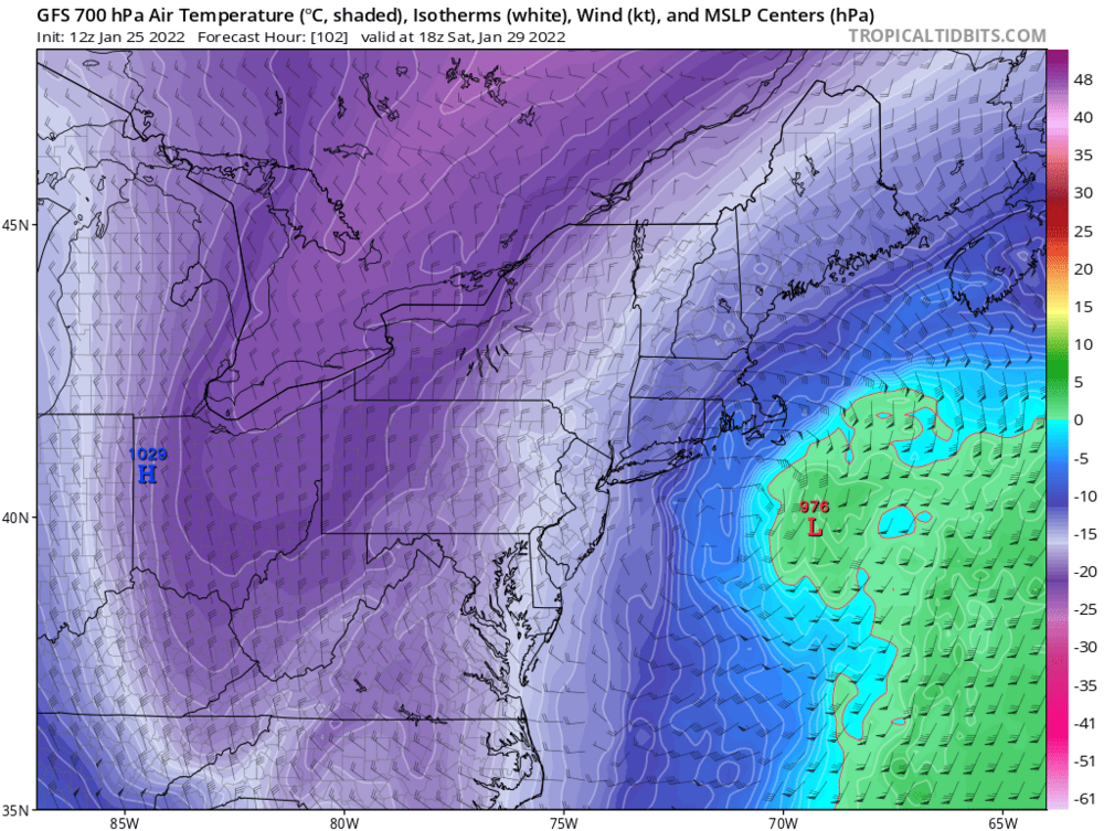
Powerful Multi-regional/ multi-faceted east coastal storm now above medium confidence: Jan 29 -30th, MA to NE, with snow and mix combining high wind, and tides. Unusual early confidence ...
in New England
Posted
Don't really like where the 700 low is developing and closing off.