

OceanStWx
-
Posts
20,346 -
Joined
-
Last visited
Content Type
Profiles
Blogs
Forums
American Weather
Media Demo
Store
Gallery
Posts posted by OceanStWx
-
-
25 minutes ago, dendrite said:
Wonder if the smoke will increase CG frequency and intensity. Let’s get a yore light show.
“The lightning did most brightly rend the heavens that night.”
-
 1
1
-
-
2 minutes ago, vortex95 said:
Having the Doppler radars now in Canada really helps for NNE radar coverage, esp. since CXX is practically useless ern semicircle.
 It still amazes me that the NWS was not allowed to put the CXX radar on a mountain top when it was installed in the late 90s. This action thumbs its nose at protection of lives and property, and should override anything else in this case.
Was that due to VT State Regulations about towers on mountain tops? It wasn't always that way, right? Mt Mansfield has communication towers.Well before my time, so I don't know.
But Canadians have dual-pol as well, so TDSs are possible to observe. I'm pretty sure I've seen a couple outside my forecast area.
-
1 minute ago, Chrisrotary12 said:
HRRR tries to bring New Hampshire into the game overnight.
I wouldn't be surprised if we get severe elevated hail overnight given those morning soundings to our west. Plenty of support for that.
-
30 minutes ago, weatherwiz said:
I wouldn't be surprised if that areas gets more tornadoes than what's realized. Dual-pol will make this easier but I bet if we had the data there would be a secondary max (if not overall max) of severe weather instances across that part of Maine, its just it does unreported because of population density. They probably end up with an overlap of favorable ingredients more times than the remainder of the region. Far enough north to be influenced by the stronger jet dynamics/shortwaves and far enough south to tap into warmer/humid air.
We'll see. We have yet to really see an uptick in TDS/tornado verification in our area. And our radar is well sited to capture stuff to our northwest.
Now if it's some moose fart north of the mountains our radar won't see that lofted debris anyway. We do catch "lost" tornadoes sometimes with satellite passes. Like sometime after 2017 a tornado track appeared in the Pemi Wilderness. No idea when it happened, but it's there.
-
 2
2
-
-
41 minutes ago, Chrisrotary12 said:
Storms dying as they approach the border.
Still waiting on the real show around 22z though.
-
2 minutes ago, tamarack said:
I don't know if Maine has ever had a confirmed EF3 (or stronger).
They have not. But it is also exceedingly difficult to rate up to EF3 with tree damage alone.
-
1
-
 1
1
-
 1
1
-
-
5 minutes ago, weatherwiz said:
I just can't get over the environment. 50-60 knots of bulk shear per mesoanalysis with >40 knots of effective shear. Forecast is for ~200 m2/s2 of of effective helicity with MLCAPE approaching and exceeding 2000-2500 J/KG. Forecast hodos. Based on what CAMS are spitting out its very difficult to believe we will come out of today without any significant severe. Hopefully anyone camping or out in those areas is aware and has shelter plans.
The thing about this event is that even if we blow the surface based opportunity, you could still rip some elevated hailers through with golf balls or greater.
-
5 minutes ago, Winter Wizard said:
In theory, wildfire smoke could be a potential fly in the ointment since it reduces surface heating and limits instability to an extent. Though the question is how much would that mix down to the surface? In this case, it probably wouldn't and I think the surface dynamics are more than enough to overcome that.
It has mixed down to MWN, so it's starting to get into the near boundary layer. The EML may help keep that off the surface until late though.
-
1
-
-
14 minutes ago, Cyclone-68 said:
If an EF3 hits a forest and nobody is around, does it make a sound?
*Unintelligible moose noises*
-
1
-
1
-
-
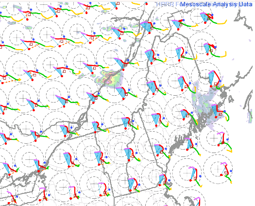
This kind of event has so much potential in New England for main reason that you rotate the entire flow pattern and create something more akin to what happens in the Midwest.
Around here you typically have much more stable air to the southeast, the complete opposite of central CONUS severe weather. Northwest flow allows stable air to be in the right top quadrant relative to the storms. Check out the line of cumulus marking the surface based instability. Also the forecast for theta-e later today. That marks the warm front, and storm motion is parallel to this. So this is the exact orientation you need for long tracked supercellular storms.


-
8
-
-
Just now, weatherwiz said:
I was sitting in the McDonalds parking lot across from BDL when the tornado warning went out and was hoping something would drop
That kind of behavior gets you on neighborhood watch lists.
-
3
-
-
Just now, Chrisrotary12 said:
Did it produce?
Two long tracked supercells that produced swaths of wind damage. Sadly for some, no tornadoes.
-
24 minutes ago, Cyclone-68 said:
Has there been any other occasion with a 10% hatched for tornadoes in New England?
One time?

-
1
-
-
12z HRRR keeping severe weather going in the GYX CWA until 08-09z tomorrow
-
1 minute ago, dendrite said:
Is Ekster at the office or still riding one of those cages at the clubs in YSC
That was the pregame. After party at GYX later today.
-
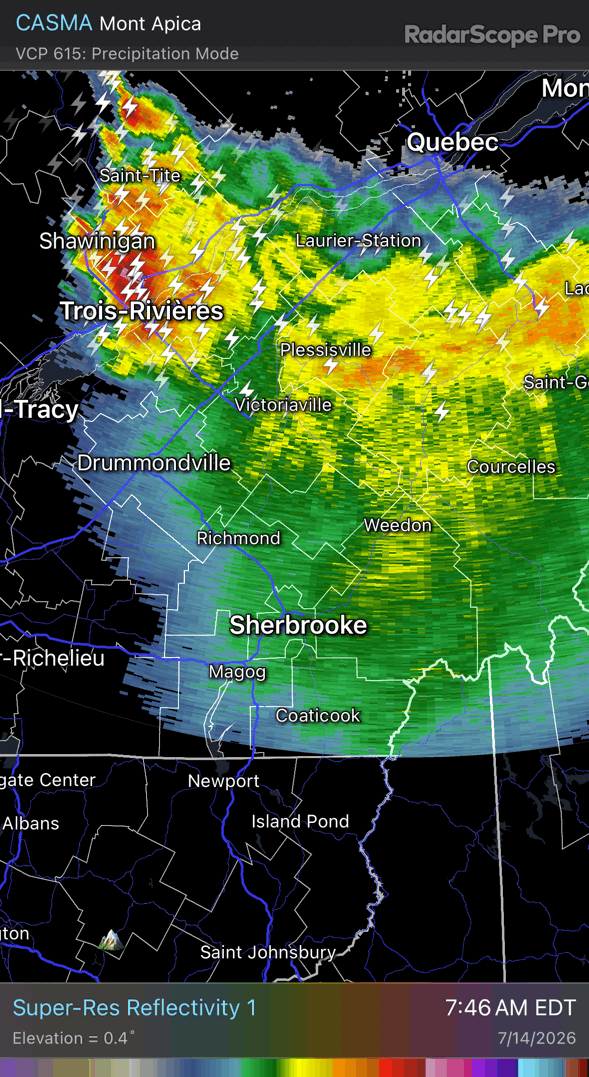
Just now, dendrite said:
Congrats moose
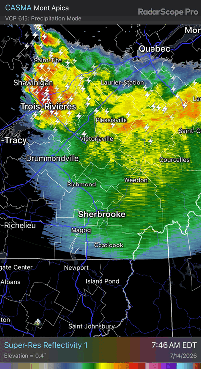
More like Sherbroke
-
-
7 minutes ago, wxeyeNH said:
Looking at the sat pics this morning there are lots of fires burning in Southern Ontario. The thick smoke plume is moving into our area. How much is this going to affect the severe storms later for NNE? Also the MCS is creating a lot of cloud cover especially this morning. So we are not getting much insolation. Maybe this will reduce convection later?
There is mixed research on smoke and storms. In some cases the smoke layer can actually hold the cap longer and allow the instability to really build before breaking (think smoke absorbs heat and warms that layer aloft). But that really depends on the height of the smoke layer.
-
4
-
-
3 minutes ago, weatherwiz said:
Do tornadoes crossing the border need a passport?

-
2
-
-
14 hours ago, vortex95 said:
Summaries I made using data from The Tornado Project.
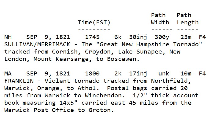
The 1821 outbreak is my Roman Empire.

-
1
-
3
-
-
1 minute ago, CoastalWx said:
I would just hold off showing it. Just makes the public confused.
Our hydrologist just won't put it in the briefings each week if we've had rain but it's not included.
-
1
-
-
4 hours ago, CoastalWx said:
NO change in drought where 3-6" of rain fell. Those maps should have been DOGE'd.
Never underestimate the power of the atmosphere to rain between the data cutoff and when the map is released on Thursdays.
-
2
-
-
1 minute ago, kdxken said:
New one to me.
It's a pretty cool visualization tool. More shading means that more ensemble members are showing something anomalous for the time of year. More black lines with higher numbers mean the most extreme ensemble members are quite extreme.
-
3
-
1
-
-
Just now, Damage In Tolland said:
What models besides the NAM and HREF which is NAM based ?
 It's 20% NAM.
-
1
-

Significant Severe Weather Event Possible for NNE on July 14 into July 15, 2026
in New England
Posted
That stuff really got entrained and concentrated ahead of the front. Surface based stuff may be a loss, but these lapse rates could produce hail all night along with a rogue wind gust.