

Ralph Wiggum
-
Posts
16,101 -
Joined
-
Last visited
Content Type
Profiles
Blogs
Forums
American Weather
Media Demo
Store
Gallery
Posts posted by Ralph Wiggum
-
-
30 minutes ago, Bob Chill said:
Gefs is north of the op but def shifted towards favoring some kind of transfer and sig precip event. Personally, I despise these kinds of setups. Too much heartbreak...
Could be a forum divider with CAPE on the winning side. I really hope the primary shifts south. I can't recall an event with the primary tracking so far north in the midwest that works out. Philly on the other hand...
We have heart breaks of our own with these up here. You say Philly can do ok....up here we say the same that we usually fail but NYC usually does good. And in NYC they say BOS. So, yeah funny how that works. NAO block ftw! C'mon lets do this even if it goes to sh!t afterwards. Need a DC-BOS special to break the ice early.
-
I'll just leave this here

-
 1
1
-
-
15 minutes ago, C.A.P.E. said:
Nearly a perfect inversion of our ideal pattern


Talk about a complete pattern rollover. Hey at least with that look we can set expectations low and there is plenty of upside. Only one way to go....cant get much worse right?
-
12 minutes ago, Bob Chill said:
Are we nervous yet? Lol
Seeing such a drastic flip of the ao/nao could be a sign that this Nov is the headfake kind and not the early season clue month it can be.
Opening Dec with a strong +ao is usually a bad omen. Way too early to jump to conclusions but won't lie... seeing all guidance converge on the same idea of a fairly robust +AO to kick off Dec is not a positive development. Entirely possible it all flips back to a blocked look quickly. Not going to overthink anything yet. Prime climo is still a month away.
What you dont like seeing all that blue in the AO/NAO regions? Guess now we hope the SSWE can reshuffle things if in fact this was/is the November headfake in play. Probably not a bad thing to roll the roulette wheel with the SPV/TPV if we are relying solely on the EPO. Been down that road before.....cold/dry is not my favored look but like I mentioned earlier I guess cold hanging around is never a bad thing as we know pattern relaxes can yield a front end thump scenario that is if the Atl and HL arent going to play nice.
-
28 minutes ago, showmethesnow said:
P15. Saw it too. Not quite sure I am ready to be shoveling 2-3 feet of snow quite yet.
Just kidding.

Just tuned up my snowblower....new plug, oil, sea foam, axle grease, hex shaft lube, wheel rotation, air, and grease, auger lube, gear lube, pulley adjustments....running like day 1. So that should be the kiss of death for any significant snow this season. You're welcome.
-
 3
3
-
-
Negative NAO pops for a period over the next 4 days before losing traction in the medium range in response to a flexing EPO ridge out West. Split flow continues off the West Coast. Strat PV taking a beating and looks to continue to do so. How that translates down to the trop as a SSWE unfolds in the coming weeks tbd but at the very least should allow for the PV to move around as opposed to be anchored in one gyre over the North Pole. Should be seeing a BN temp regime trying to set up during the last few days of November into December as the EPO ridge takes over the flow out West into the Plains and possibly lead to some CPF eventually spilling East.
With that said, Thanksgiving week is and has appeared to be a week of transition irt the overall hemispheric pattern. There was uncertainty as where it would head leading into the start of December but we are beginning to see some agreement among guidance. EPO ridging will be the main player heading into the LR with an active pattern/stj evolving. Whether we can get the Atl side to play nice or the PV sets up over Hudson Bay with little HL blocking keeping the flow fast and furious over the Northern tier and Northeast will be something to watch. Seems the pattern evolution wont be horrible. Could see a clipper-type pattern trying to take shape. If we can get any blocking during such a period would yield greater potential for a slow mover. But alas, cloud talk at this point.
This GEFS plot does pose some interest and I believe this is a period that deserves some monitoring as the pattern setup has some potential. 50/50 sets up following the holiday as the EPO ridge flexes allowing for a fresh cold air supply. Some ridging (waning) is still seen over the Eastern NAO region but is slowly being pushed out by a piece of the PV dropping into the Baffin Bay region. A piece of UL energy is moving into the Eastern Plains and there are signs that a +PNA may briefly pop in conjunction. So this is a somewhat threatening look. If the PNA is real and can help force the UL energy farther S and under us that could yield a trackable event. Is a period the keep an eye on as the season is finally upon us.

-
A sad sad time in the computer model forecast world. It appears the CRAS, after season upon season of being a well-respected forecast tool, has been discontinued.
-
Proof that really locking onto any one particular ens mean solution past day 10 even day 7 is dangerous territory. Where we were once seeing ridging in the NAO region across the board is now being replaced medium range with the shortest-lived -NAO ever and going 180 replaced by an anchoring PV potentially. Not the worst look.....think quick hits/progressive. EPO ridge should help with the cold. Of course this is purely speculation post 180 hours. But I think the SPV battering (which has been forecast relatively well actually) is starting to throw fits at the trop. Going to be interesting to see how it plays out...a SSWE can be linked to a reshuffle of the 500mb hemispheric pattern....not clear where we will end up. I hope the look of lots of blues up top and oranges down at ML doesnt verify personally, but we've seen worse. I guess cold is better than warmth right?
-
11 minutes ago, RedSky said:
Hey Ralphie that is 10-15" over or near 50% above average snow for Philly. He cloned last winter but added more snow. Entertaining video by the cane.
Right I forgot I'm thinking KDYL.
-
Hurricane's winter outlook is out. Low solar activity, near normal to slightly above (30-35") snowfall. He and I are on similar pages which that sort of company I will gladly take!!
-
Hey, I'm really liking the Flyers core and youth. Should actually make a push this year. Farabee and Frost are exciting. Myers on D has been a welcome piece. TK playing well. Most vets playing solid. I still think Jake needs to go. Losing faith in Ghost too. But I am hearing Patrick is progressing nicely and may return sooner than later.
-
Any non weather related stuff and/or general banter that may derail the actual obs and weather threads goes here.
-
42 minutes ago, frd said:
What is your opinion of the AO trends? A divergence here.
Latest is even more so. Can not get that one to post.
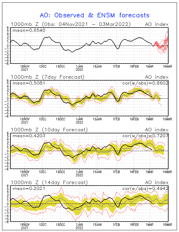
Trends have been good, no doubt. Going neutral and neg as we move farther along in fall is never bad. It does have to level off at some point, can only go so low and remain there so long. I think that the EPO is sort of a reflection of that balance. I can see a pattern where the EPO ridge develops and propogates East with bridging to the NAO while the AO fluxes states between + and - thru the winter. I had HL blocking as a key player in my outlook and think that holds. Just need to see what form it takes and how it morphs in between phases.
-
1 hour ago, Ralph Wiggum said:
Seems that since the HH run a few evenings ago when this thread was brimming with confidence irt the LR -EPO/-AO/-NAO trifecta looks things have become more muted in the LR especially in the AO/NAO regions on some guidance as the PAC is taking on the dominant player look and is trying to show signs of running the show as early as day 8. As usual, grain of salt past 240. But we can see the NAO goes negative as early as Sunday but around the same the time or soon after, the EPO ridge is beginning to try and flex which is the new player on the field emerging. With that said, where we were once seeing the NAO establish and bleed into the AO the pulsing EPO appears to dampen out any HP over the pole while the NAO slowly fades. You can also see on the ens how the EPO starts a bit west and in turn pumps a SE and even an argument for a S Central ridge before migrating towards the west coast (hopefully but again that is post 240). Like someone said, it is refreshing to see a 50/50 pop now and then so with an EPO ridge and no NAO it has that transient quick-hitter kind of look thump to you know what sorta flow if that pattern held during early climo. So not a total fail nor a total victory sort of pattern coming up. Just one where caution is still urged and I'm not sure anyone knows where this is going to head in Dec right now. Thanksgiving week as stated is going to be a transitional week....it is either a reload as the pattern relaxes and resets or a complete reshuffle of the deck where we start seeing the PaC play bully and push the Atl around as has been so common in recent years.
(Attached are the EpS and GEFS day 10....big diffs at HL. FWIW the GEPS is more like the EPS in keeping the NAO neutral/neg.)


-
1
-
-
Speaking out loud here but watch....we finally get a pattern that may feature NAO blocking and a neg AO periodically and a SSWE comes along and could muck it up. You know how the saying goes, careful what we wish for. I dont see any red flags tbh nor do I see any victory parades being scheduled. Steady as she goes for now. But how we emerge from T-Giving week as our transition and press into Dec is going to be telling imho.
-
1
-
-
38 minutes ago, C.A.P.E. said:
Its pretty clear now that whatever NA blocking does develop, it will break down around the Dec 5th time-frame. So it makes some sense we will get our 12/5 snowstorm. After that the EPO will bring the big cold and hopefully a clipper type pattern, as anything amped will likely cut if the NAO goes positive as advertised.
How r u that confident the NA fizzles Dec 5 when we dont know where we are headed 180 hours out? Could go either way. I guess if u look at the 384 ens and weeklies there is support for what you are saying and heck it may be accurate. But that is conjecture at this point....we've seen this LR thing do a 180 as recently as the NAO development which wasn't even supposed to occur just 240 hours ago.
-
Seems that since the HH run a few evenings ago when this thread was brimming with confidence irt the LR -EPO/-AO/-NAO trifecta looks things have become more muted in the LR especially in the AO/NAO regions on some guidance as the PAC is taking on the dominant player look and is trying to show signs of running the show as early as day 8. As usual, grain of salt past 240. But we can see the NAO goes negative as early as Sunday but around the same the time or soon after, the EPO ridge is beginning to try and flex which is the new player on the field emerging. With that said, where we were once seeing the NAO establish and bleed into the AO the pulsing EPO appears to dampen out any HP over the pole while the NAO slowly fades. You can also see on the ens how the EPO starts a bit west and in turn pumps a SE and even an argument for a S Central ridge before migrating towards the west coast (hopefully but again that is post 240). Like someone said, it is refreshing to see a 50/50 pop now and then so with an EPO ridge and no NAO it has that transient quick-hitter kind of look thump to you know what sorta flow if that pattern held during early climo. So not a total fail nor a total victory sort of pattern coming up. Just one where caution is still urged and I'm not sure anyone knows where this is going to head in Dec right now. Thanksgiving week as stated is going to be a transitional week....it is either a reload as the pattern relaxes and resets or a complete reshuffle of the deck where we start seeing the PaC play bully and push the Atl around as has been so common in recent years.
(Attached are the EpS and GEFS day 10....big diffs at HL. FWIW the GEPS is more like the EPS in keeping the NAO neutral/neg.)
-
4 minutes ago, psuhoffman said:

How Dietz Nuts taste? Are they delicious?
-
14 minutes ago, Bob Chill said:
I'm excited about the med term and what it implies down the line... in just 4-5 days we should have the strongest -nao we've seen early during season since 2010. Complete agreement the upper level ridge closes off and parks for a while.
It was noted yesterday on some of the ens that those looks.may have legs as you could see some of the transition by days 8ish. So I'm with you and when u r optimistic that's not a bad thing. Just urging caution for some on any specific surface solutions at 384hrs+ lol.
-
I feel like with the flip of a switch many posters are back to looking past 240 hours and getting their hopes up. And based on a HH op run at that. I admittedly took a peek but I urge optimistic caution lest we forget last winter.
-
2
-
 1
1
-
-
17 minutes ago, Bob Chill said:
The numerical calc is 1000mb pressure but we all know what a good h5 look is no matter the numerical index.
These type of long range op looks keep happening and it's intriguing. Not that I think the gfs is right or anything but seeing these solutions are a potential clue that an extreme blocking event is possible

I was just looking at the LR GFS from 18z just for kicks and noted how convoluted of a pattern is appeared with a massive positive SD anomaly over the Aleutians and a fairly crud PAC BUT up top and the N Atl actually allows for workable conditions. Might be venturing into a season where we see some crud looks yet miraculously they deliver? We can hope anyway and tbh I wouldnt be surprised. We are sort of due even tho I realize that isnt how science works.
-
Geez, gorgeous GEFS runs at 6z and seeing some repeating themes. Noteworthy items...WAR which seems to always be a feature these days instead of locking in or feeding the SE ridge like last year appears to be more of a player in feeding the NAO ridge. Ridge N of Hawaii doesnt lock in destroying the ML Pac flow but rather appears to help pump and feed the EPO ridge down the road. AO goes bonkers negative and appears to hang in for the extended. Lower heights under the region as December approaches. CPF trying to set up. Split flow out West continues. Aleutian low does reload briefly but appears to setup again later on. There isnt anything not to like at this time tbh. I wouldnt call it a unicorn/epic or any of those terms but if verbatim is pretty much almost exactly what we would want to see moving forward. Of course some of this IS past 240 so grain of salt as always but even by day 8ish you can see the pattern reloading and key features trying ti redevelop so it may not be too far off in some of the ideas. I am especially intrigued by the base pattern that is slowly starting to show itself across all ens families. Getting there slowly but surely. Let's get thru next week because as I mentioned a few times, that seems to be the transitional week with a reloading or changing of the pattern. Want to see how we come out of that before celebrating any premature victories for the region(s).
-
3
-
-
5 hours ago, cbmclean said:
For what it is worth on the cpc page giving the NAO/AO conditions, the label says 500 mb for the NAO but 1000 mb for the AO.
.
"The North Atlantic Oscillation (NAO) is a weather phenomenon in the North Atlantic Ocean of fluctuations in the difference of atmospheric pressure at sea level (SLP) between the Icelandic Low and the Azores High."
Obviously I would be more inclined to side with CPC and how they determine the NAO but I found that wiki article contradictory of what the CPC uses to measure. It seems odd that two of the big oscillation patterns would be gauged on 2 different atmospheric levels....apples to apples sort of thing.
-
3 hours ago, WxUSAF said:
If you want something positive to look at, select northern hemisphere MSLP anomaly on the 18z GEFS and scroll to about hr160+. Lots of red in Santa land means a -AO.
Is it correct that the AO and NAO phases are actually based on surface pressures more than 500mb/geopotential heights?


December 2019 Med/Long Range Disco
in Mid Atlantic
Posted
Thought this was worth noting on the GEFS. Past few runs show less of a trof near the NAO region towards the end of the range (240) I pay attention to and more of a ridging look. Isnt a stout -NAO look by any means but delays the flip to a +NAO with each run.
Eta: the growing blue ball in the midwest isnt horrible. Maybe we can score some sort of quick hitting NS system if that look holds.