.jpg.82995912781a8a839ab578c3b293f48f.jpg)

weatherbo
-
Posts
6,475 -
Joined
Content Type
Profiles
Blogs
Forums
American Weather
Media Demo
Store
Gallery
Everything posted by weatherbo
-
I have 8-12" on average with wind prone areas showing bare ground in a few spots. The Tamarack weather station in Calumet still has 24".
-
After tagging 70 yesterday the first thunderstorms in 6+ months rolled through overnight dropping .52" exacerbating the ongoing flooding issues. Creeks and rivers running high with some even out of their banks at levels I haven't seen in a few years. light rain/fog/45 at noon. Will need a fire today to take the chill out of the house.
-
First 70 of the season! Snow continues to melt and I'm gonna bet inland lakes will be ice free this weekend.
-
Beautiful sunny day in the mid 50's before the lake breeze hit, dropping temps down into the 40's. Cool sat shot today of the remaining snowpack.

-
Low of 13 here. Coldest I can find in the UP is 5 degrees just nw of here @ the Yellow Dog/Eagle Mine station. Sun and mid 40's should make for a pretty decent day.
-
Spent the day in Houghton yesterday then drove the spine of the Keweenaw down to Ontonagon County to check out Victoria Dam Falls. Never seen anything quite like it. The falls created their own rain. My bad on the audio, I had my finger over the microphone by mistake.
-
19 0vernight here. The high today should stay just below freezing then fall into the mid-teens tonight. Might be the last teens of the season as temps warm to the 50's and low 60's by mid to late week and that would be fine with me.
-
Meanwhile, in the UP... rapid melt ongoing. The persistent fog this month has returned and is ushering in much colder weather for the next couple days that will slow the melt before temps warm again next week.
-
This is by far the nicest day since last Autumn. Zero wind and 64. The sun feels so good. lol The melt had been slow with cool temps and fog for the past week but has accelerated the past two days. Going to check out some waterfalls this weekend but will likely do it with some snow showers around. Measuring 32" off the driveway this afternoon... and going quick.
.thumb.jpg.ebc4611669d33c70100498ab3216501d.jpg)
- 224 replies
-
- 11
-

-
39 degrees this morning, hoping for a high in the mid-50's. Days and nights should remain above freezing for the next week. NWS MQT mentioned most of the UP should be snow free by the middle of next week with the exception of the Keweenaw and the high terrain along Superior from Herman through here and down to Negaunee where 3 to 4 feet of snow still remains. Put the rain gauge out yesterday for the first time since October and recorded .5 inches last night. Snow depth here is just over 40" with drifts and piles still 5-6' in spots where the snow was piled all season. Went out to the back of the property yesterday to check my hunting shack and see how it fared the winter, and it's still standing.
.thumb.jpeg.51a23fc6ebcd2b1debf121947f1e2e9e.jpeg)
-
Haha! West Ishpeming was -13.
-
With fresh snow and clear skies, it ended up getting a little colder than the forecast indicated with -1 here at the house. A cool day in the mid 30s today before rain showers and some 40’s to near 50 to end the week.
.thumb.jpg.053d47cea9d9b6e9452b00d1664d845c.jpg)
-
3-4 inches of windblown snow fell in a pretty short span today. Current temp is 19 with a forecast low of 8. The last single digit of the season...?
-
Spring has yet to arrive in Marquette County. There's been a handful of days above freezing but no real significant thaw weather to speak of. Snowpack is about as dense as it gets with 16-18 inches Liquid locked in. A shot of colder air this evening into tomorrow could yield 4-6 inches locally. Looking ahead, snow is probably not done but maybe big storms are. A few pics from this morning.
.thumb.jpg.bc1757949a79a189a6aac19e73e0c9b4.jpg)
.thumb.jpg.e3bfada82fdbf118a0781b1bb0737902.jpg)
.thumb.jpg.89106401c9f4d8128155cd09d8f98056.jpg)
- 224 replies
-
- 20
-

-
-

-
Had an inch of snow earlier and now it's sleeting with occasional snowflakes mixing in. Brisk east wind, 27 degrees. A solid 40" glacier in place.
-
low to mid 20's all day.
-
The 10th Anniversary of the Dead River Flood 23 years ago, worst case scenario.
-
Road was opened sometime during the night finally. Was beginning to think they forgot but I know this area is far from a priority. Some sun and low 30's for the drive in. Just a phenomenal snowpack in place.
.thumb.jpg.b148ce5e3c314bb05370a8350c0515a3.jpg)
2.thumb.jpg.3ebd3c6b517158dba81dc297697ac71e.jpg)
- 299 replies
-
- 16
-
-
As of this afternoon, they're @ 347.5". On average they'll still receive another 40" and I've seen a lot of big dogs in April. Also, Herman has 68" otg with a LE of probably 18". The snow will NOT be gone by mid April in the UP. I routinely still have snow into the 1st and 2nd week of May.
-
As long as we keep a fire going, the heat from the stovepipe creates a hollow cavity around the stack, even if the snow accumulates a foot or two higher than the pipe. But obviously shovel it out as soon as possible just to keep it free and clear and to avoid ice issues. The first thing I did when moving here was to reroute the furnace exhaust off the roof and have it exit the sidewall up high just beneath the roof soffit. That worked out well until this year. Keeping the snow cleared is a job you def don't want to fall behind on.
-
This was definitely one for the books. Just goes to show what mid-west/great lakes climate can churn out from time to time. Now on to spring!


-
You'd finally get your fill of snow! This is what 5.5+ feet of snow looks like. Pretty much standing in the same spot as the late August pic this past Summer. Took some weight off the roof as well. Inside the house is like a cave. EDIT: The lesser snow on the left side of the pic is a path i blew to the propane tank a few weeks back.
.thumb.jpg.3d0e39c862f82eb199a5a3c7ecbed964.jpg)
.thumb.jpg.8ffe17758073ea48d9625eb91547c165.jpg)
.thumb.jpg.a6f185d720da9735362f3448425bf055.jpg)
- 716 replies
-
- 13
-
-
I have and sometimes still do. Back around 2014-2018 I reported almost daily but it became too much of a chore. MQT gave me my two official snow stakes that I still put out each year for shits and giggles.
-
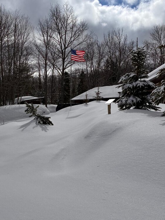
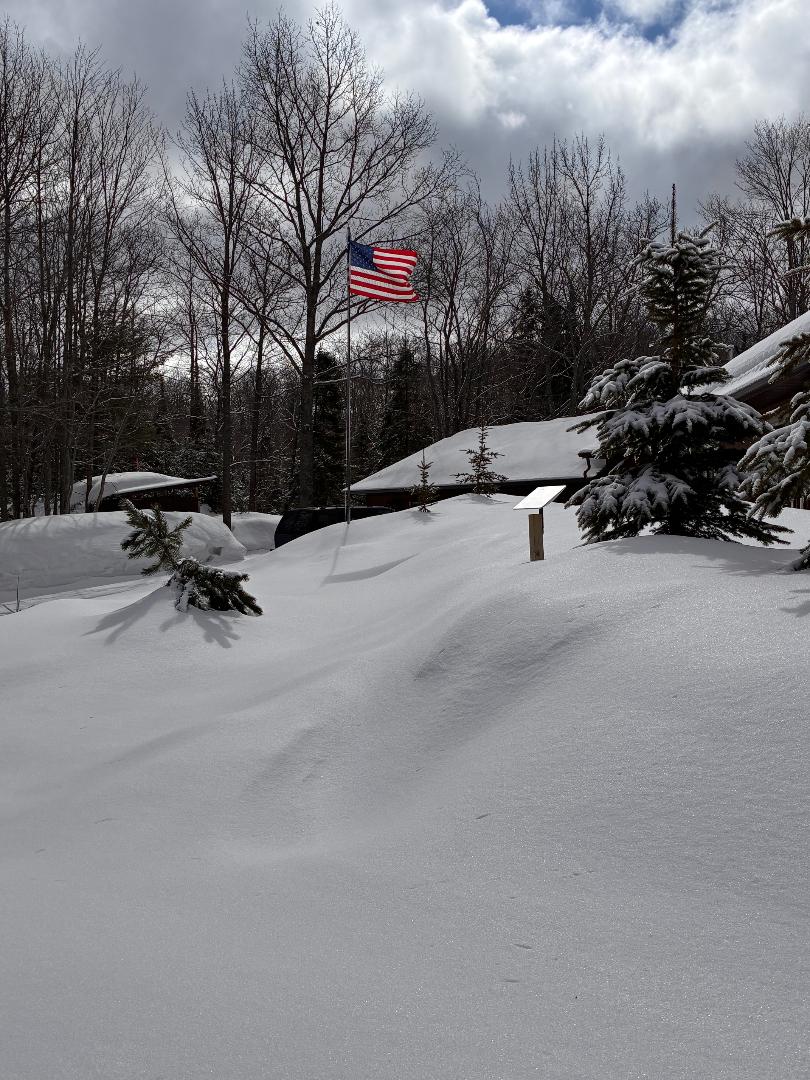
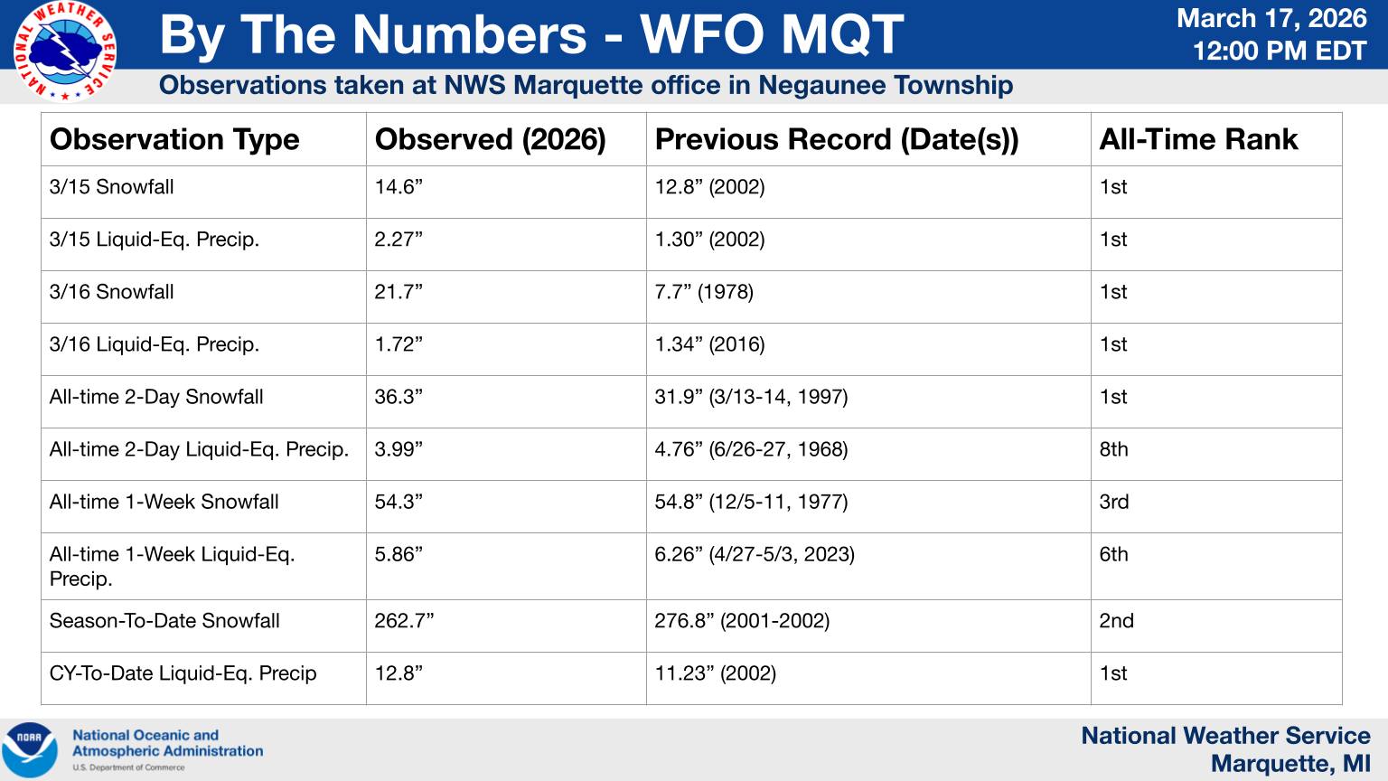
Somewhere around 300". I'm usually pretty close to Herman's totals and they stand at 341" as of today but there were a few times this winter they were hit a bit harder than me. Measuring snow here is damn near a fulltime job and I just don't care as much as I use to. However, from Friday through last night I've received an estimated 55" while MQT officially stands at 48.1" during the same time, with a season total of 262.7". Today starts the cleanup. There's 4-5' drifts of wind-packed snow across the entire driveway this morning and while I do have a Kubota tractor, this is still going to take some time. Will try to post a few more pics today.
-
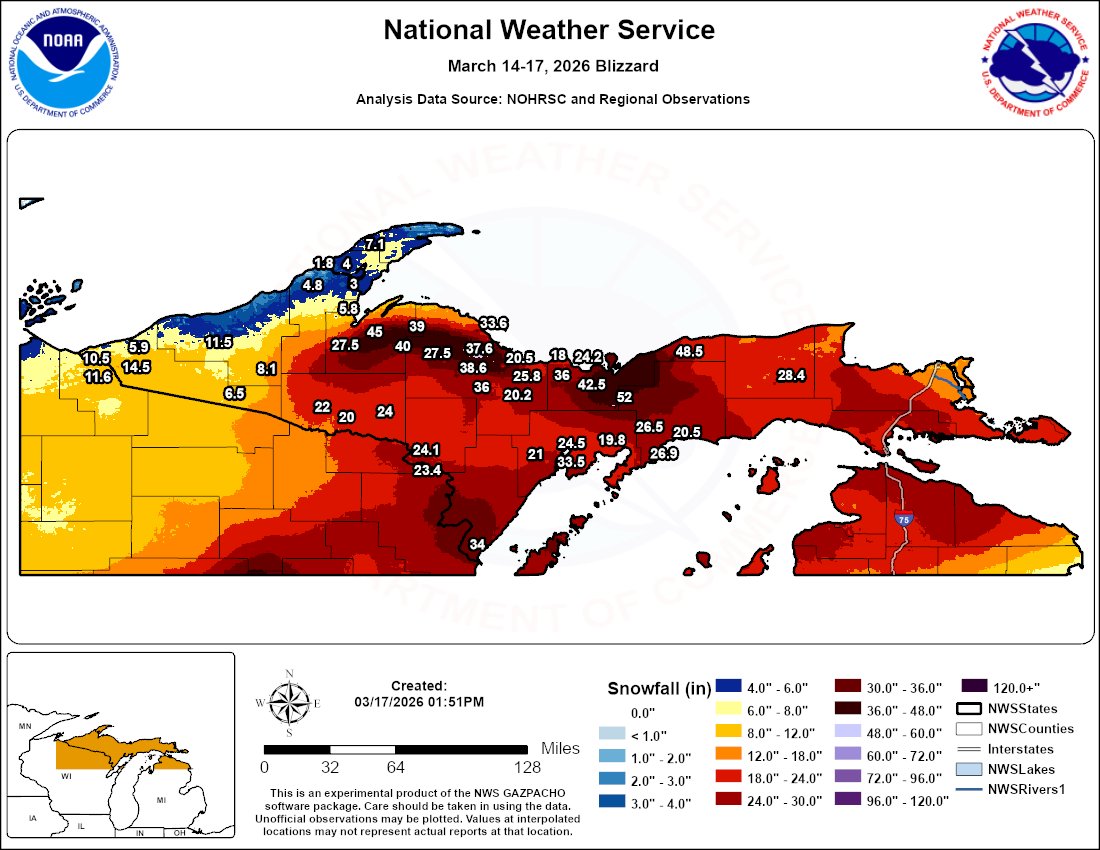
2' is still a lot of snow especially this time of year when the thrill is def over. At least we are only 6 weeks away from May. MQT received 33.7" (LE- 3.79"). Probably nearing 40" out this way. Good to see you were spared the ice!


.jpg.45a2c296fb2cedd7f117dcd64695d30e.jpg)
.jpeg.62fb3a290a461d3dd7ed948caf5b92ac.jpeg)

.jpg.2b9f3a6aa6e105cba97d0a551004fd72.jpg)

.jpg.ac458ca479b6b56109d186c8d142e41d.jpg)
.jpg.9d42c7b5b646f80f9a52aeb6670ab65f.jpg)
.jpg.028344ad1159cdd281ba5468279a1e08.jpg)

.jpg.7992b5ab75ca0e13802f18ae762d0dba.jpg)
2.jpg.65f6bd3e6f209237fd3553fa79f9e60e.jpg)
.jpg.5b8688b35f2d7b4869d74dbd628ce61e.jpg)
.jpg.f1d94c24c673dab80d61f06ba016d8d7.jpg)
.jpg.9506928314a74a31353e1e40b29739ac.jpg)