

Dunkman
-
Posts
2,080 -
Joined
-
Last visited
Content Type
Profiles
Blogs
Forums
American Weather
Media Demo
Store
Gallery
Posts posted by Dunkman
-
-
59 minutes ago, SnowDeac said:
Radar looks awful for the Charlotte area. Starting to fill in nicely RDU, GSO, Asheboro. 2nd round cancel?!
It's all zr right now I don't think you're missing out
-
14 minutes ago, Queencitywx said:
Just want to point out that’s the 18z RGEM
Lol thanks. I need to sleep probably.
-
1 minute ago, hickory said:
Anyway you can post? Am NE of Greensboro already sitting at .10 of ice and it's still heavy drizzle. Most forecast were calling for .10 max
Sure

-
 1
1
-
-
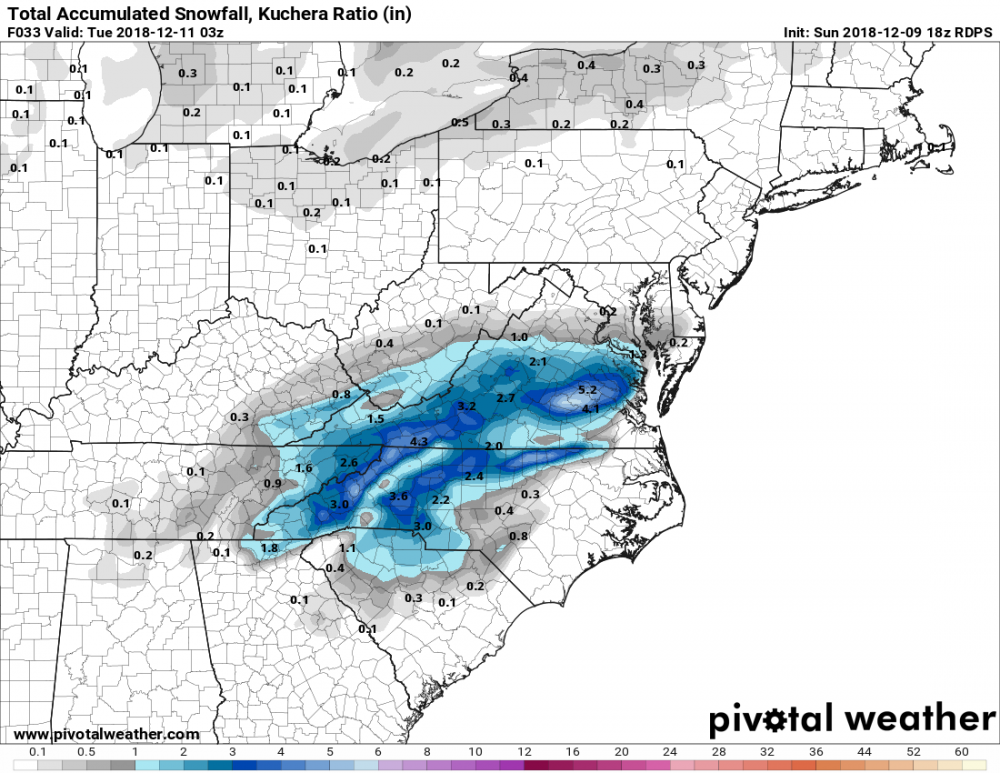
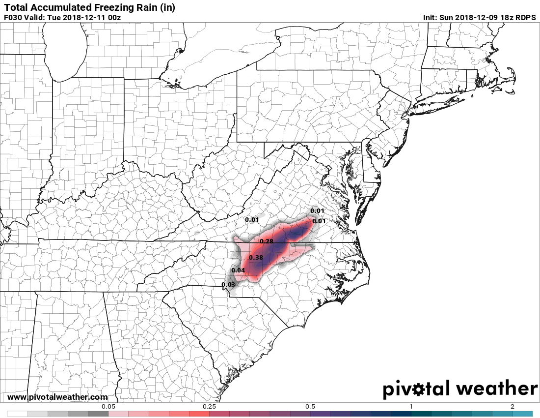
There's actually a pretty substantial stripe of ZR on the RGEM from the Triad and points ENE.
-
7 minutes ago, SouthWake33 said:
Can anyone post RGEM accumulation maps? RAP?
-
1 minute ago, SouthCentralWakeCo said:
True, but it is interesting. Didn't the NAM verify the best for the last nights/today's band of snow/sleet/freezing rain? Not sure, just asking.
There were some people on the edges of the transition zones in which the NAM seemed to give the most accurate forecast but as a whole it was pretty bad for this event compared to the other guidance.
-
1 minute ago, weatherlover said:
Do upper air temps support snow?
Probably location dependent but in general temps are supposed to get better as the night goes on and into the morning hours.
-
Just when I thought we were done it started absolutely pouring snow here again. Wild storm, need like half an inch for 12.
-
Just measured 11" but the transition line is close. Instead of nice flakes we're just getting a bunch of mostly dust now. It's gonna be close.
-
 1
1
-
-
It was snowing so hard I couldn't get a decent picture. Sigh. Anyway, 9"+ and counting here.
-
 1
1
-
-
A solid 8" here north of High Point as of about 10 minutes ago. Really seems like we may have a shot at a foot before it changes over.
-
2
-
-
Just want to say I'm glad we can go back to treating the NAM like crap. This new world in which it was a trustworthy and respectable model was not a place I was comfortable living.
-
Up to 7" here now. If it stays snow for another 7-8 hours as has been forecast we're gonna have one for the record books.
-
1
-
-
3 minutes ago, Poimen said:
I'm going to measure again in about 10 minutes. I'm curious to see how much has accumulated in the last hour. I'm guessing somewhere between 1.5-2."
You dealing with a lot of drifting? I had a hard time getting a solid measurement because of it.
-
Wow, so I was expecting to wake up to 2 maybe 3 inches. Got almost 6. Gonna be something if we stay snow as long as has been forecast.
-
1
-
-
My point and click has me at 9-16 now. I'd take 9 in a heartbeat and be thrilled about it, they sure are optimistic at RAH tonight.
-
1
-
-
24 minutes ago, kvegas-wx said:
Watching CLT piss away all this QPF just trying to drop 5 degrees has me worried for the Triad. If we get to 1am and all I see are posts about mixing, virga and nothing yet, the majority of this board is going to start having flashbacks. Its never easy here......ever.
I do feel bad for those in SC and GA that invested heavily and are coming up empty. You need another surprise 6" snow in downtown ATL!
Our WSW doesn't even start until 1am. Isn't that what's supposed to happen?
-
3 minutes ago, CarlHill said:
Yep, and 3 years running, if I question or bitch about it I get silenced on here. I suppose we can't question, doubt, or criticize here without being put in the quiet corner. But seriously, there have been times when people were dropping $1000 on generators due to overhype on these boards and got nothing but cold rain.
You should make decisions based on NWS forecasts. I promise you the meteorologists in your local weather office take into account everything that is discussed here in the forecast.
-
1
-
-
1 minute ago, Cornsnow said:
That's not good right? If it's in Asheville it does not bode well for other areas, correct?
It's fine that's just the column cooling down. Has nothing to do with the warm nose that may/will push in later.
-
2
-
 1
1
-
-
2 hours ago, superjames1992 said:
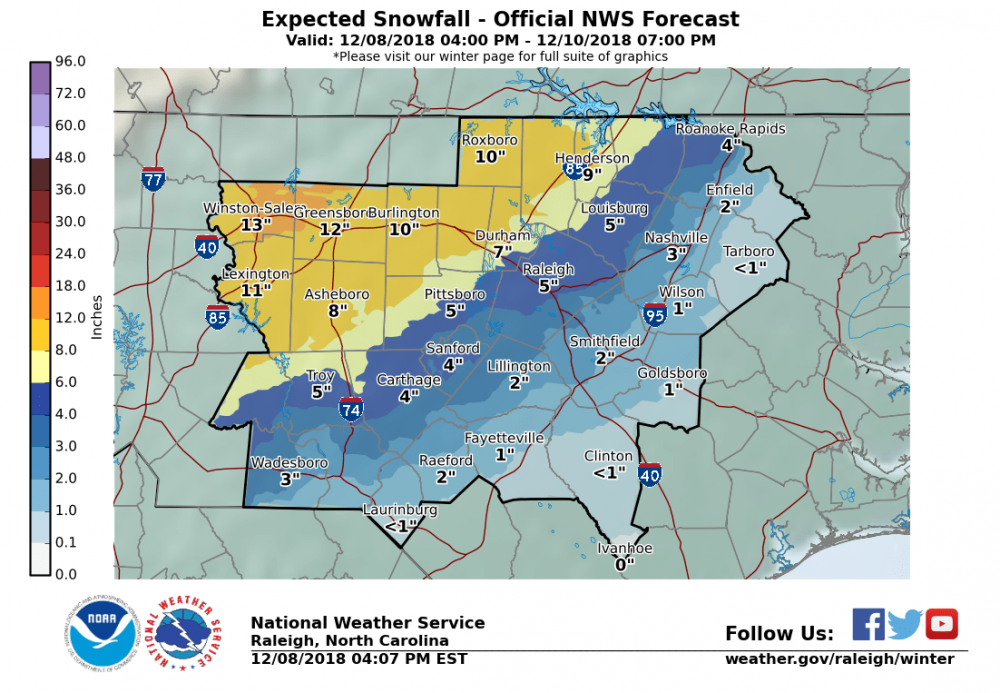
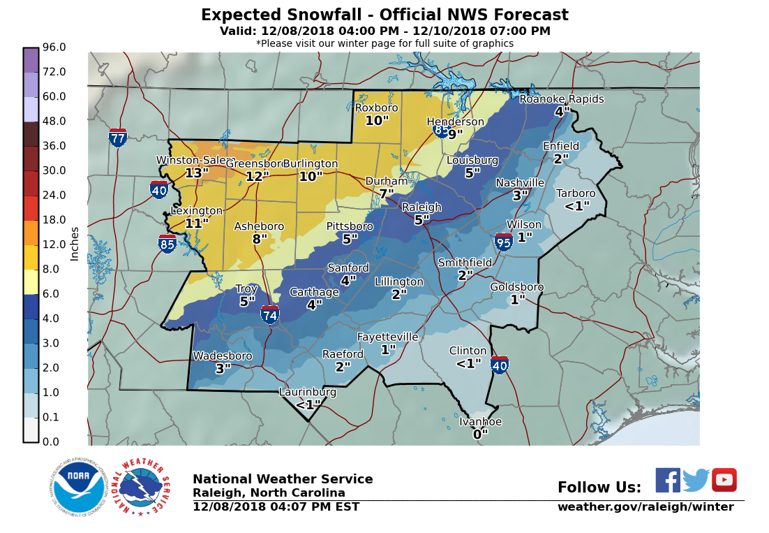
Hey, man, you're going to have a nice storm as long as you haven't bought into some of the "historic" storm hype (maybe for the northern mountains). Looks like a typical 6-8" snow/sleet/ice mixed bag for the Triad still to me. A front end thump of snow that's exciting followed by an infuriating length of sleet after that that makes you wonder what could have been. See: February 2014, December 2009, etc....

Wouldn't be surprised if the precip arrives earlier than expected, either, which seems common with these. The timing with regards to the time of day seems decent for the Triad, at least, not that the sun angle is any significant overriding factor this time of year, anyways.
Thanks, yeah I hope so. Takes a perfect setup for us to stay snow when the QPF approaches an inch or more and this is not that. I'll be happy to take our usual this early in the season.
-
1
-
-
2 minutes ago, Poimen said:
RAH doubling down in the Triad

Here's the number guesses instead of ranges. I haven't had a foot at my house since I bought it in 2006. Not expecting it this time either but it's nice to see.
-
2
-
-
1 minute ago, burgertime said:
GFS brings a second round on Monday. I don't think I've ever seen a clown map for NC on a global that looked like this, this close to an event. Unreal.
We'll see what ends up happening but I was wondering if the second round may start showing back up on some models. It's the kind of thing I recall showing up very late in the modeling more than once in the past.
-
I remember a few years ago we had a basically all sleet storm. It was kind of amazing in its own way. We had something absurd like 5" of sleet but the really crazy thing was the foot deep sleet drift on my back deck where it had rolled down the roof and piled up. I don't remember how long exactly but it took forever for it to melt. Feels like it may be time for another one of those. Also instead of snow cream we tried to make snow icees from the sleet. Do not recommend. Maybe get some fruit flavored syrup instead of vanilla/sugar/milk or something.
-
5 hours ago, burrel2 said:
It'll be nice to have some company for once in here!
Oh we're all going to be in here for this one I think!

December 8-10 Winter Storm Obs
in Southeastern States
Posted
Nice fluffy light to moderate snowfall here in north High Point. It's really beautiful, great sized flakes.