

Dunkman
-
Posts
2,080 -
Joined
-
Last visited
Content Type
Profiles
Blogs
Forums
American Weather
Media Demo
Store
Gallery
Posts posted by Dunkman
-
-
4 minutes ago, Cold Rain said:
What has been the reason this thing has been steadily weakening in the face of what has continually been modeled to be a good environment for strengthening?
Upper level wind shear sending dry air into the southern half of the system.
-
 1
1
-
-
1 minute ago, HKY_WX said:
Its interesting to note the entire rain shield is likely displaced north of the coc right now.
We spent days thinking this wouldn't be the usual east coast half a cane on approach and, umm, oops?
-
 1
1
-
-
2 minutes ago, olafminesaw said:
It may partly be a function of a different part of the eye being exposed, but it appears that Flo has taken a big step to the West over the past few hours.
Definitely need to use a more long-term motion when dealing with a ragged eye like this. It's gonna wobble all over the place.
-
 2
2
-
-
9 minutes ago, ILMRoss said:
For the umpteenth time today Florence is trying to figure out how to eye wall.
Don't know how big of an issue dry air really is, we'd probably see more examples of outflow arcs racing away from the center on VIS if it was reallllllyyyyy a big problem.
If southerly shear has been over the storm all day, that's probably helped with some sinking air on the south side. If winds aloft have a slight southerly component, then winds are starting to turn counterclockwise with height- backing winds. That's going to cause the air to sink, and it's probably why we haven't seen any CDO maintenance on that side of the storm whatsoever.
If this shear really is expected to abate, we'll probably see any CDO persist a little longer.
What do you think about the coastline perhaps providing some friction to help Florence tighten up a bit? Seems like we've seen that happen in the past.
-
12 minutes ago, yotaman said:
Good, keep weakening. I would love to wake up tomorrow and see a sub 100 mph storm.
You may see one at 11 if this is all recon finds.
-
People on Ocracoke know the risk they're taking. We can look at the same circumstances and think they're reckless but they aren't ignorant of their situation. People living there have experienced many hurricanes.
I mean yeah it's still a dangerous storm and will have a surge much larger than you'd expect for the winds. That said, recon found cat 1 winds on that SW to NE pass. 90mph is not 140mph I don't care how big it is. Certainly seems like the rain will be the biggest story, which I think is what many people thought all along.
-
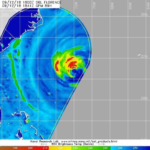
Here's a recent mw pass. The morphed image loop is pretty but I'm not sure how useful it is (especially when it's a day old).
-
On the last recon pass they measured category 2 surface winds 50 miles north from the center. I think pretty much every model has the storm getting that close or closer to Jacksonville at some point.
-
1 minute ago, griteater said:
By hr72, it has dropped due south out over the open water, then into a position just NE of Charleston, right along the coast
The surge is going to be held in place by relentless onshore winds for days it seems in certain places.
-
5 minutes ago, jjwxman said:
So how about this forecast for Greensboro from RAH... is this their way of telling folks not to let their guard down? Seems a little over the top to me based on the forecasts... Thoughts?
I mean right now you have 111mph flight level winds 110 miles north of the center. And the hurricane force wind radii seem to only be expanding. I certainly think they're trying to be proactive but I wouldn't call it ridiculous with a storm this size. Strong rain bands can absolutely mix those winds down to the surface at times.
-
1
-
-
33 minutes ago, bugalou said:
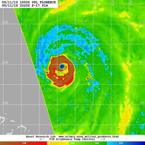
Microwave imaging sure seems to look like its headed toward and eye that big.
Do you happen to have links to some current microwave imagery? The most recent I could find is almost 10 hours old.
-
1
-
-
I didn't expect this storm to get the classic east coast comma shape with weaker/drier west and south sides but it certainly looks to be taking on that appearance. Maybe it's just temporary but it could be tough to maintain cat 4 with that structure.
-
5 minutes ago, jayson said:
Satellite presentation is starting to look a bit better, but something def was eroding the SW quadrant. It has likely been a Cat3 for the past few hours.
There has definitely been some shear but it shouldn't persist much longer.
-
Well highest SFMR on the first pass was 101 kts. FL was a little better at 126 but Florence may have trouble maintaining cat 4 now with the expanded wind field.
-
6 minutes ago, mackerel_sky said:
High Risk excessive flash flood risk , issued by WPC! It’s only the 2nd time it’s ever issued one of those!! The 1st one was issued for Harvey!!
I know it's a fairly new product but that's still really freaking ominous.
-
5 minutes ago, irishbri74 said:
Any eta on recon arrival?
Should be about to enter the storm, looks like they're making a SW to NE pass to start.
-
It's pretty hard to tell what's going on with core dynamics from an IR satellite. This pass was from like an hour ago:
-
1
-
-
2 minutes ago, TriPol said:
Has there ever been a storm that's stalled right before making landfall in the Carolinas?
Yes, but I only ever remember it happening with tropical storms and a category 1 (I think it was Dennis maybe?) Even then it was devastating as water steadily backed up into rivers and sounds. It's hard to imagine what that looks like if it's a category 3-4 stalled off the coast.
-
1 minute ago, Blue_Ridge_Escarpment said:
That’s what I said. Nothing north of Wilmington. That appears to be northern extent. No model has any thing north of there.
12z UK went well north of Wilmington.
-
It doesn't look like any models really want to strengthen the storm much from here on in which would certainly be a blessing. That said, satellite is looking better all the time.
-
15 minutes ago, Chinook said:
Did anybody post the hurricane recon plots from AF308 Mission #7 into Florence? I can't find the data on Tropical Tidbits since the mission is over. It's just so neat to see these plots from Tropical Tidbits. If not, I am curious about the vortex data message pressure/ max FL wind/ max surface wind.
I have it saved on google earth. I'll post the vortex data messages and let me know if there's anything else you'd like.
Product: Air Force Vortex Message (URNT12 KNHC)
Transmitted: 11th day of the month at 12:55Z
Agency: United States Air Force
Aircraft: Lockheed WC-130J Hercules with reg. number AF98-5308
Storm Number & Year: 06 in 2018
Storm Name: Florence (flight in the North Atlantic basin)
Mission Number: 7
Observation Number: 15A. Time of Center Fix: 11th day of the month at 12:31:50Z
B. Center Fix Coordinates: 26.51N 64.84W
B. Center Fix Location: 400 statute miles (644 km) to the S (181°) from Hamilton, Bermuda (U.K.).
C. Minimum Height at Standard Level: 2,668m (8,753ft) at 700mb
D. Minimum Sea Level Pressure: 951mb (28.09 inHg)
E. Dropsonde Surface Wind at Center: From 165° at 8kts (From the SSE at 9mph)
F. Eye Character: Closed
G. Eye Shape & Diameter: Circular with a diameter of 32 nautical miles (37 statute miles)
H. Estimated (by SFMR or visually) Maximum Surface Wind Inbound: 108kts (124.3mph)
I. Location & Time of the Estimated Maximum Surface Wind Inbound: 19 nautical miles (22 statute miles) to the ENE (63°) of center fix at 12:26:00Z
J. Maximum Flight Level Wind Inbound: From 150° at 143kts (From the SSE at 164.6mph)
K. Location & Time of the Maximum Flight Level Wind Inbound: 21 nautical miles (24 statute miles) to the ENE (62°) of center fix at 12:25:00Z
L. Estimated (by SFMR or visually) Maximum Surface Wind Outbound: 107kts (123.1mph)
M. Location & Time of the Estimated Maximum Surface Wind Outbound: 17 nautical miles (20 statute miles) to the SW (232°) of center fix at 12:37:00Z
N. Maximum Flight Level Wind Outbound: From 330° at 108kts (From the NNW at 124.3mph)
O. Location & Time of the Maximum Flight Level Wind Outbound: 17 nautical miles (20 statute miles) to the SW (232°) of center fix at 12:37:00Z
P. Maximum Flight Level Temp & Pressure Altitude Outside Eye: 12°C (54°F) at a pressure alt. of 3,048m (10,000ft)
Q. Maximum Flight Level Temp & Pressure Altitude Inside Eye: 15°C (59°F) at a pressure alt. of 3,049m (10,003ft)
R. Dewpoint Temp (collected at same location as temp inside eye): 7°C (45°F)
R. Sea Surface Temp (collected at same location as temp inside eye): Not Available
S. Fix Determined By: Penetration, Radar, Wind, Pressure and Temperature
S. Fix Levels (surface & flight level centers within 5nm of each other): Surface and 700mb
T. Navigational Fix Accuracy: 0.02 nautical miles
T. Meteorological Accuracy: 2 nautical milesRemarks Section:
Maximum Flight Level Wind: 143kts (~ 164.6mph) which was observed 21 nautical miles (24 statute miles) to the ENE (62°) from the flight level center at 12:25:00Z
Maximum Flight Level Temp: 16°C (61°F) which was observed 13 nautical miles (15 statute miles) to the ENE (68°) from the flight level centerProduct: Air Force Vortex Message (URNT12 KNHC)
Transmitted: 11th day of the month at 11:10Z
Agency: United States Air Force
Aircraft: Lockheed WC-130J Hercules with reg. number AF98-5308
Storm Number & Year: 06 in 2018
Storm Name: Florence (flight in the North Atlantic basin)
Mission Number: 7
Observation Number: 08A. Time of Center Fix: 11th day of the month at 10:47:30Z
B. Center Fix Coordinates: 26.35N 64.40W
B. Center Fix Location: 412 statute miles (663 km) to the S (177°) from Hamilton, Bermuda (U.K.).
C. Minimum Height at Standard Level: 2,669m (8,757ft) at 700mb
D. Minimum Sea Level Pressure: 951mb (28.09 inHg)
E. Dropsonde Surface Wind at Center (Undecoded): NA
F. Eye Character: Open in the north
G. Eye Shape & Diameter: Circular with a diameter of 34 nautical miles (39 statute miles)
H. Estimated (by SFMR or visually) Maximum Surface Wind Inbound: 98kts (112.8mph)
I. Location & Time of the Estimated Maximum Surface Wind Inbound: 16 nautical miles (18 statute miles) to the NW (319°) of center fix at 10:42:30Z
J. Maximum Flight Level Wind Inbound: From 56° at 113kts (From between the NE and ENE at 130.0mph)
K. Location & Time of the Maximum Flight Level Wind Inbound: 22 nautical miles (25 statute miles) to the NW (317°) of center fix at 10:40:30Z
L. Estimated (by SFMR or visually) Maximum Surface Wind Outbound: 112kts (128.9mph)
M. Location & Time of the Estimated Maximum Surface Wind Outbound: 15 nautical miles (17 statute miles) to the SE (136°) of center fix at 10:52:00Z
N. Maximum Flight Level Wind Outbound: From 223° at 113kts (From the SW at 130.0mph)
O. Location & Time of the Maximum Flight Level Wind Outbound: 19 nautical miles (22 statute miles) to the SE (135°) of center fix at 10:53:00Z
P. Maximum Flight Level Temp & Pressure Altitude Outside Eye: 11°C (52°F) at a pressure alt. of 3,046m (9,993ft)
Q. Maximum Flight Level Temp & Pressure Altitude Inside Eye: 15°C (59°F) at a pressure alt. of 3,053m (10,016ft)
R. Dewpoint Temp (collected at same location as temp inside eye): 6°C (43°F)
R. Sea Surface Temp (collected at same location as temp inside eye): Not Available
S. Fix Determined By: Penetration, Radar, Wind, Pressure and Temperature
S. Fix Level: 700mb
T. Navigational Fix Accuracy: 0.02 nautical miles
T. Meteorological Accuracy: 2 nautical milesRemarks Section - Remarks That Were Decoded...
Maximum Flight Level Wind: 113kts (~ 130.0mph) which was observed 22 nautical miles (25 statute miles) to the NW (317°) from the flight level center at 10:40:30Z
Remarks Section - Additional Remarks...
CENTER DROPSONDE TERMINATED AT 13M WITH WINDS 140 DEGREES 12 KNOTS
-
GFS and getting a clue 3 days late. Name a more iconic duo.
-
1
-
-
950mb/130mph at 11am. I'm a little surprised they didn't bump the winds back up to 140 given what recon found but it hardly matters.
-
1
-
-
1 minute ago, NJwx85 said:
Okay two passes. The past missions included many more passes.
The NOAA plane was flying out of Bermuda which was ~400 miles away. The AF plane is flying out of Savannah which is ~1100 miles away.
Major Hurricane Florence: STORM MODE THREAD
in Tropical Headquarters
Posted
Looking at recon observations so far there is no real eyewall left at all. It's just a huge area of category 1 winds.