

Dunkman
-
Posts
2,080 -
Joined
-
Last visited
Content Type
Profiles
Blogs
Forums
American Weather
Media Demo
Store
Gallery
Posts posted by Dunkman
-
-
7 minutes ago, Poimen said:
Should the RGEM concern us? It's basically a sleet storm for even the Triad. I seem to recall that it has performed well in the past.
Absolutely. As you know I'm sure, it can always sleet here. We've had mostly IP storms when the models never even hinted at mixing until in the short range.
-
 1
1
-
-
Looks like the RGEM is what, at least 75 miles north of any other guidance with the heaviest precipitation? Definitely an outlier, however given our history of NW trends as a storm approaches and the RGEM's reputation I certainly wouldn't completely discount it.
-
2 minutes ago, beanskip said:
That's one of the scariest maps I've seen on these boards. Greenville and Spartanburg would never been the same -- and Charlotte/Rock Hill wouldn't be much better.
Yeah 1.39 ZR = be prepared to not have power for a week. There's going to be an unlucky ice zone it seems, just hope it isn't that large and doesn't last that long.
-
3 hours ago, superjames1992 said:
Feels a lot like that for the Triad to me. Usually mix with a lot of sleet in these storms. I think 6-8" is a good call.
Or maybe I'm just vindictive and bitter since I live in Florida now and the Triad looks in line for a good storm. I don't know!
I'm also expecting our usual 6-8 with a little of everything mixed in. This doesn't feel like an all snow setup. Or even mostly snow.
-
1
-
-
RAH with 8-12 for GSO and 1-2 for Raleigh...I guess that's about right for the last few years. You may have a much better city but at least we get the snow!
-
3 minutes ago, tarheelwx said:
I thought RGEM was excellent for temps in CAD situations. Anybody confirm?
TW
Seems to maybe do better in the MA and points north? It has done well here too but took it on the chin from the NAM in a couple recent events.
-
1
-
-
9 minutes ago, BornAgain13 said:
Yeah sorry about that... "for VA".
Nah, for everyone. It was a much better look than 12z and 18z and what we really needed was just for it to stop trending in the wrong direction.
I mean I guess the ice isn't a look everyone wants but just as far as having a winter storm we were another couple NAM warmups away from this being all rain outside of the mountains.
-
54 minutes ago, wake4est said:
Weird I have no functional memory of that. Must have been really terrible for us.
We got like a dusting in the triad iirc. I'm pretty sure I went and did a trail run in it and it had all melted by the time I got out of the shower.
-
Modeling was consistent for the most part and RAH went from 1-2 in the Triad to 10+ in, what, a day? Less than a day? Yeah that makes sense. Whatever, bring on the storm!
-
I mean the Triad had a couple years recently in which we had more inches of sleet than snow on the season. I'd never count out a raging sleet storm, especially in a CAD event. Just historically in these very mixed events we (again, piedmont triad) usually seem to end up with snow at the beginning and end, something like 4-8", and then a bunch of crap in the middle. The sum total of the guidance so far seems (to me at least) to fit with that general narrative.
-
1
-
-
35 minutes ago, Poimen said:
One disturbing thing is that the GFS soundings are consistently showing less than full saturation in the snow growth region early Sunday morning, which coincides with the heaviest precip and coldest portion of the storm through the column. I'm not sure what to make of that, but I'd like to see full saturation up there.
Sounds like a lot of pingers which I am definitely concerned about. Good for sledding I guess.
-
7 minutes ago, PackGrad05 said:
Greg Fishel just said either a rain or snow event. He isn't predicting a lot of mixing or in between.
I've heard a lot of people (mets) say that over the years. And then we mix.
-
1
-
 1
1
-
-
3 minutes ago, PGAWx said:
Seriously RAH? I get you want to be conservative but 1 inch for the triad looks absurd right now.
I'm not going to pretend to have a better feel for this than RAH does but I did find it kind of interesting that they opened saying it looked like a significant winter storm and then proceeded to forecast conditions that are very much not significant for the region.
-
6
-
-
8 minutes ago, southernskimmer said:
We need to stop living and dying by each model run. A variety of solutions are on the table and it’s impossible to nail this far out . Long way to go before anybody reels anything in.
If we were ever gonna stop living and dying with every model run it would have happened by now.
-
5
-
5
-
-
1 hour ago, ILMRoss said:
There's also counties in that dma that are pretty far south of the triad. I think she is being a little conservative but it goes without saying that a full fledged "omg it's going to snow" message would freak people out, and if that forecast is blown less people may watch that station. There is palpable pressure, from the sales department to the news director, to have this right. Before I got into broadcast, I thought, "oh hue hue hue I'm going to be brazen and I'll speak my mind!" but it's *a lot* harder said than done.
Yeah I need to get new sleds for my kids tomorrow so if she (and the other local mets) could be conservative until tomorrow evening that would be perfect.
-
1 hour ago, Windspeed said:
Haha that's an awesome typo!
Recon is getting close.
Edit: Actually, scratch that. They were en route and even descending to an operational altitude, then suddenly did a 180° and are heading back over the Mexican mainland. Perhaps something is wrong?
-
1
-
-
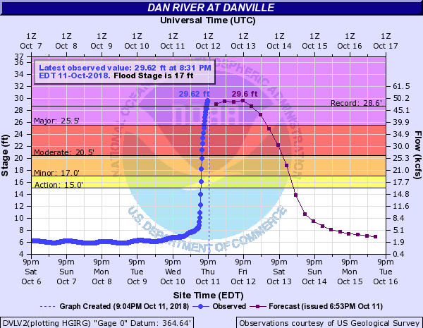
The situation with the Dan River in Danville is truly awful tonight. It's a foot over the record now with no real signs of being near a crest.
-
 2
2
-
-
RAH finally sounding the alarm on the band of heavy wind on the backside in their latest briefing
https://www.weather.gov/media/rah/briefing/NWSRaleighLatestBriefing.pdf
-
 1
1
-
-
I mean yes it's overdone I don't think anyone is expecting 90mph gusts. But can you rule out 70? Probably not?
-
1
-
-
I don't know, I'd certainly think about including the Charlotte metro up through the Triad. People here have done absolutely nothing to prepare in any way. Should be interesting tomorrow.
-
6 minutes ago, Orangeburgwx said:
124kt (150mph) winds found by the aircraft at flight level...
Is this b**** going to go Cat 5?
Oh they've found 130 knots in the last half hour. Classic rapid intensification going on tonight. Best hope now I guess is that it peaks and begins to weaken before landfall.
-
4 hours ago, downeastnc said:
MHX already got TS conditions in forecast for MBY.....that forward speed is a issue as far as wind goes along and east of the track could see some decent gust especially over the IBX/OBX
ThursdayTropical storm conditions possible. Showers and thunderstorms likely. Mostly cloudy, with a high near 83. Chance of precipitation is 60%.Thursday NightTropical storm conditions possible. A chance of showers and thunderstorms. Mostly cloudy, with a low around 68. Chance of precipitation is 50%.Yeah with the enhancement from the front it looks like there will be a huge area of TS winds north of the track.
-
1 hour ago, hickory said:
Yes I will agree this is a significant event for NC, but with that being said If you live near a river or the coast line this is to be expected a few times in your lifetime. There is going to be massive flooding. I dont know am just not impressed yet. That opinion could change over the next few days but so far am like meh...
It says in the freaking title of the thread "no saying the storm isn't that bad plz." We aren't here for your spicy hot takes. Try harder.
-
1
-
-
1 minute ago, Solak said:
Another ERC?
There isn't even an eyewall left at this point so I'd say definitely not.
Southeast Sanitarium - A Place to Vent
in Southeastern States
Posted
I have a feeling everyone who isn't in the mountains or Virginia is gonna end up here before we're done. As for us in the triad, I really don't like being a few miles from disaster on both the NAM and RGEM.