

Dunkman
-
Posts
2,080 -
Joined
-
Last visited
Content Type
Profiles
Blogs
Forums
American Weather
Media Demo
Store
Gallery
Posts posted by Dunkman
-
-
10 minutes ago, griteater said:
This says the TVCN is a combination of: AVNI (GFS), EMXI (ECMWF, or Euro), HWFI (HWRF), CTCI (NRL COAMPS-TC w/GFS initial boundary conditions), and EGRI (UKMet)
Yeah it could have been COAMPS instead of HMON. Those are the models they used last year. For some reason I thought they had tweaked it this year but I've been trying to find where I saw it and can't so there's a good chance I just imagined it.
-
Just to add, I believe for 2018 the TVCN is equally weighted GFS, ECMWF, UKMET, HWRF and HMON. (I actually can't find where I saw that but I think that's what I remember reading)
-
I posted this in the main thread as well but recon just found 165 mph flight level winds in the NE quad. Was definitely hoping the ewrc had dropped the winds more than this.
-
143 kts. FL wind in the NE quad on this latest recon pass. First eyewall dropsonde of this run measured 130mph at the surface as well. Florence hasn't weakened much if at all it seems.
Also of note, tropical storm force winds were measured on a dropsonde 125 miles NE of the center.
-
 2
2
-
-
18 minutes ago, mempho said:
In case anyone wants something fun to do over the next couple of evenings....
A good drinking game for major hurricane threads is to take a shot of tropical liquor (rum/tequila) every time someone uses the word "annular."
Sent from my SM-G950U using Tapatalk
DO NOT do this in the comments section of Dr. Masters blog. You will die.
-
1 hour ago, Jakkel138 said:
Since storm mode thread was posted, i'm gonna just lurk. I've had some problems with posting too much yesterday.
I acknowledge that storm mode is a very serious thread and involves tracking a dangerous/deadly hurricane which has to potential to cause significant loss of life and destruction of property. Therefore i'm gonna take it seriously.
I think it's better to just lurk when you're very new and have less than 500 posts and learn from other posters.
I've been here since the site launched and tracking hurricanes for 30 years and I mostly just lurk the main thread at this point. Sometimes I'll post some images I think would add to the discussion but when there are a dozen or more actual meteorologists in the thread my analysis is pretty worthless.
-
8 minutes ago, ncskywarn said:
Start of a new trend? stay tuned. NAM is coming in SW of 18Z at hour 51
I don't trust the NAM, or really anything outside of the operational EC, UK and GFS, to have any chance to resolve this complicated steering pattern. Even if the NAM does stumble into an ultimately correct solution it's probably more of a broken clock being right twice a day scenario.
-
I posted this in the main thread as well but from the mw pass a couple hours ago it does look like some definitely core reorganization going on. I don't know if I'd call it a full eyewall replacement but there's a secondary maxima on at least half of the storm.
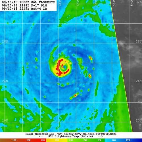
-
Here's a microwave from a couple hours ago if some people didn't see it:

-
 1
1
-
-
Point stands though it's still a large spread at 84 hours.
-
1
-
-
36 minutes ago, Orangeburgwx said:
Eye looks ragged, the storm size is about to explode after its EWRC... Still moving due west atm based off both the IR and visual aids
Ragged? And no eyewall replacement cycle. It just developed a proper eyewall recently.

-
8 minutes ago, downeastnc said:
Its all about the blend.......some models will be to far right, some will be to far left, that's why the NHC etc use a consensus and go down more pr less down the middle....so far the FV3 has been pretty good at being in the middle of the spread
Exactly this. Actually the TVCN consensus model has been beating even the official NHC forecast tracks recently. Similarly, the IVCN consensus is the best bet for intensity.
As for the GFS, I really think it's just missing on the strength of that ridge. Be nice if the GFS got one right for a change though.
-
1
-
-
So those WPC forecasts aren't entirely automated but they do lean heavily on the GEFS and NCEP numerical models.
-
NOAA "Kermit" was supposed to take off at 12z from Bermuda for a mission. Awfully hard to get recon into this storm (although that should change today).
-
56 minutes ago, WinstonSalemArlington said:
Is DC/NoVA not a good place to evacute to?
Landfall at like MHC and a slow drift and stall up to the NC/VA line is going to inundate the DC area with much of the rain that the Euro has going into central and western NC. And the DC area, as you know I'm sure, has had a ton of rain already in the last couple months. It's on the northern edge of the danger area for sure but definitely still in it.
-
The NC coast can take a hurricane. This isn't the northeast. People know what to do. There will probably be a lot of damage but they'll be ok. I'm expecting the rain to end up being much more dangerous than surge or wind.
-
1
-
-
47 minutes ago, BIG FROSTY said:
Joe Bastardi Retweeted Joe Bastardi
First ideas on flooding with this were last Thur/Fri but worry was centered more in Va to Pa. In any case honing in now a bit further south,
Joe Bastardi added,
Joe BastardiVerified account @BigJoeBastardiSince Wednesday we have had this going inland over NC and then crawling into VA. Should this turn out correct, this is likely to be the worst natural disaster on record for Carolinas into VA Major hit combined with 3-4 feet of rain in some places over 3-4 day period.Show this threadWith Floyd in the history books this seems a little premature.
-
2
-
-
25 minutes ago, Gibby said:
You're probably right. I was just hoping she'd slow down enough for me to squeeze in.
I think there's a good chance that the weather will be ok at 5pm Thursday in Raleigh. The problem is that there are a lot of other factors in play. You don't want to get a flight crew stuck there, or a plane. And cancelled flights in other locations may also have an impact. I'd definitely take the earlier flight if you can.
-
17 minutes ago, ncskywarn said:
WOW HWRF 195 Kt=225 MPH at the 850 level at hour 120. Looks definitely plausible when you look at the bottom 2 images.
Yeah the SSTs support at least a category higher than normal, probably more than that in spots. Strong category 3 is usually the worst case scenario for NC but I'm not sure that's the case this time.
-
17 minutes ago, NJwx85 said:
Damn, thought they might try and run missions from Kauai.
Yeah I was pretty bummed that they left so early but I suppose we were fortunate to get recon for the storm.
-
2 minutes ago, NJwx85 said:
Does anyone have the latest aircraft data?
They already evacuated ahead of the storm
-
Looking at the current satellite I think the big island disrupting the northern outflow is impacting the storm much more than the shear, at least so far.
-
27 minutes ago, Justincobbco said:
The fact that some of you are discouraging people from posting reasonable maps that are in long term (hence the name of this thread) is just disrespectful....they are more informative than many posts that read like "brick you gonna get some up your way"....not pointing anyone out just an example!
.300h clown maps are substantial impediment to quality discussion. A banterish post is a one off thing that is easily skipped. Many times one 2 week clown map can spawn pages of bad posts that derail the entire thread. You may not understand what I'm saying or disagree and that's fine but I don't think the site is likely to reconsider.
Don't really have much to add about the event this weekend. Just doesn't look to be enough cold outside of the mountains.
-
1
-
-
Starting to look like it's just not our year triad north and west. Maybe I'll squeeze out 1" to add to my 1.5" season total.
Hurricane Florence
in Southeastern States
Posted
Looking at the Euro ensemble tracks from 00z it's almost as if they smoothed out the tracks that many of the other models are seeing. Like instead of going NW until off of ILM and then due west the EPS just goes WNW the entire time and ends up in more or less the same spot after 120-144h.