

Dunkman
-
Posts
2,080 -
Joined
-
Last visited
Content Type
Profiles
Blogs
Forums
American Weather
Media Demo
Store
Gallery
Posts posted by Dunkman
-
-
It's important to note that this isn't an in situ event. It doesn't really matter whether clouds roll in at the right (or wrong) time to lock in warmth or let it escape. This will ultimately be controlled by air that the high pressure funnels into the region. Considering my winds are out of the SE right now I'm not really sure what impacts the current dewpoints are going to ultimately have.
-
 3
3
-
 1
1
-
-
Just now, CaryWx said:
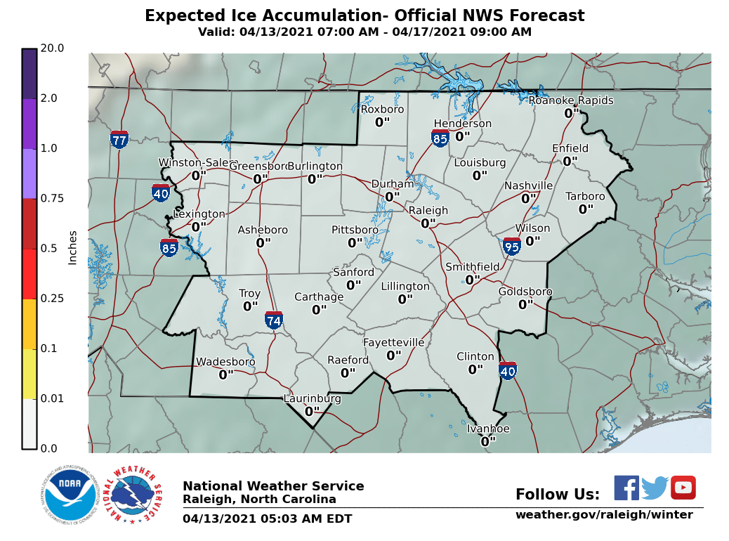
This is likely overdone for Wake right? Or cold biased?
All of the above. But I wouldn’t rule out warning criteria ice either.
It looks like I may be living in front of the fireplace for a few days.
-
4 minutes ago, olafminesaw said:
FRAM isn't a model, it's an algorithm that calculated true accrual of ice. It tends to be much more conservative than just straight accumulation maps.This is why it's concerning, because it will account for the portion of the rain that's just runoff.
It tries to. I still have real questions about accrual if it’s gonna be 50 degrees at 850mb. We’ve had numerous potential ZR events bust over the years due to heavy rates and stout warm noses.
-
4 minutes ago, wncsnow said:
Blacksburg early thoughts

RAH is somewhat more aggressive with the totals into NC.
-
7 minutes ago, NC DataDude said:
Is it the 2m temps "on top" of this radar signature?
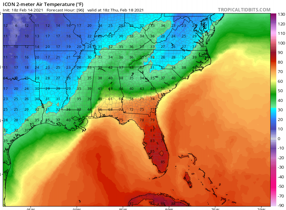
Yeah the ICON shows ZR and sleet as rain. I’d imagine those bright returns near the snow line in VA are sleet and all the rest is ZR.
-
1
-
-
46 minutes ago, magpiemaniac said:
30% of Duke Energy customers in Guilford County are without power.
Only about 10% of High Point electric customers are still without power now after hitting 50% late this morning.
I feel very fortunate to have only lost it for a couple hours.
-
1
-
-
2 minutes ago, TriadDeac said:
Just lost power in NW High Point at the same moment the WSW was issued.
Eek, still holding on here near Barrow road. Looks like about half of the 40k High Point energy customers are out as of now.
-
39 minutes ago, magpiemaniac said:
I’m checking out WPC’s latest freezing rain forecast maps and my backyard has an 80% chance of 0.10”, a 70% chance of 0.25”, a 40% chance of 0.50”, and a 10% of 1.00”. So what does RAH know that WPC doesn’t? Or does WPC just churn out verbatim model data?


That’s definitely just raw model output.
-
5 minutes ago, Berlin1926 said:
Lighter precipitation too....
I don’t know what to think about that. The NAM has been far too dry at times with multiple systems in the last month.
-
1
-
-
14 minutes ago, PantherJustin said:
Am I the only person who actually would like an ice storm? Yes I lived thru 2002. I just like extreme weather
If I didn’t have falling trees to worry about them probably. I rooted for hurricanes growing up on the coast as well.
That would be one heck of a sleet storm if the soundings are right. I remember getting about 1.5” of qpf as sleet a few years ago and it was wild. We ended up with like a 20” iceberg on the back deck from where the sleet would funnel down the roof.
-
1
-
-
1 minute ago, NorthHillsWx said:
That’s a CAD locked in long duration freezing rain/sleet event. Globals are not good at CAD specifics at this range but you’d be hard pressed to come up with a more textbook look for a major ice event for large areas of the Carolinas and Georgia
I would hope a lot of us could sleet in northern NC if there’s ZR in Macon Georgia but who knows.
-
5 minutes ago, wncsnow said:
Verbatim it warms up from CLT to RAH
Yeah no way that happens with that look.
I can’t speak for anyone else but I’m gonna fire up the generator this week and make sure it’s working.
-
2
-
-
That big bright band over Guilford is like 90% sleet. On the plus side it’s put a nice icy coating on things if we can get some snow.
-
2 minutes ago, wncsnow said:
Maybe my thread starting privileges haven't been revoked after all @jburns
Plz to not be jinxing the event before I change over. Thanks.
-
15 minutes ago, strongwxnc said:
33.5 and all snow.
Based on what I’ve seen from observations roughly anywhere inside the 1 degree 925mb line seems to be mostly snow or at least frozen.
-
1
-
-
I feel really bad for the people in the upstate who have to watch the HRRR slowly take their nice band of snow away run by run today.
-
Just now, WeatherWeenie87 said:
The NAM features a cold front coming from the gulf LOL
 Think this may be a outlier.
The NAM is really good at showing every possible solution over the course of a couple days regardless of how based in reality they may or may not be.
-
1
-
-
10 minutes ago, wncsnow said:
If the Euro is correct the cold never really comes at all the next 10 days. Instead we get the insult to injury of rain after rain after rain
It’ll get here at the end of March like it always does. Seriously though as has been said the cold holding back like this is not at all unusual. And it does usually get here eventually. It’s just torture after some of the runs this week.
-
This is another miss in the Triad. Such a rough winter. I’ve seen snow half a dozen times and it hasn’t totaled a half inch.
-
Just now, Tealsnowball said:
What gives me pause at the moment is the HRRR. My question is, what is it seeing or not seeing in comparison to the NAM? Why does there appear to be so little moisture with the HRRR?
The HRRR could be right of course. That said it’s shown very little skill outside of 6-8 hours this winter from what I’ve seen. I wouldn’t worry too much.
-
2
-
-
1 minute ago, franklin NCwx said:
That warm nose as modeled on the nam is hard to believe
Why do you say that? At least in central NC it’s pretty typical.
-
1
-
-
Yeah the 3k NAM cut back on what it was showing in central NC for tomorrow as well. I think there will be flurries flying around but that may be about it.
-
That band in the mountains looks really stout if you user a higher tilt from GSP. (You can see all the snow that’s falling but not making it to the ground.)
-
1
-
-
9 minutes ago, olafminesaw said:
Yeah, I remember someone posting somewhere a map a while back (may have been weatherbell?), that attempted to calculate true accrual.
I found some slides on FRAM which were mostly what I was looking for. One interesting thing is there wasn't much evidence of temps below -2C helping with ice accrual. At that point it seemed like rates and even wind were bigger factors. https://vlab.ncep.noaa.gov/documents/10157/137122/FRAM_VLAB_Presentation.pdf/50ff7877-c52d-80f4-1413-b294db7710e9


February 18-19 MAJOR Ice Storm Threat
in Southeastern States
Posted
Unfortunately this heavier band is all ZR so far in N High Point. I was really hoping for some sleet.