

wncsnow
-
Posts
8,644 -
Joined
-
Last visited
Content Type
Profiles
Blogs
Forums
American Weather
Media Demo
Store
Gallery
Everything posted by wncsnow
-
This is not a true Miller A. There isn't much circulation with the storm. Too much energy in OH valley.
-
I'm trying to return to the world of the living. Forgot how bad norovirus is. I'm completely drained literally and figuratively
-
The NAM 3km has a heavy band of snow rotate in about 9p.m.
-
I haven't been able to go out and measure but eyeballing it looks about an inch
-
Trust the NAM I guess
-
At least we broke the streak.
-
Looks like a bust fellas
-
My luck is pretty bad to get norovirus last night. Can't even get out of the bed to enjoy it but I'm hoping you all have a great day
-

1/10-11 super awesome winter SE OBS thread
wncsnow replied to strongwxnc's topic in Southeastern States
I was hoping I could avoid it but I have caught the same stomach bug my son has had. Will be looking at the snow through the windows this time. -
-
Better sleep tonight so you can get out and enjoy whatever happens tomorrow!
-
RAP
.thumb.png.0a7c2db551f42a759b925dfc739cd1ff.png)
-
GFS
.thumb.png.aada906a48dc42ed20d442b30dc69de8.png)
-
1/10-11 super awesome winter SE OBS thread
wncsnow replied to strongwxnc's topic in Southeastern States
21/11 It's cold -
FV 3
.thumb.png.d7704a2dc9b2b7797cad4bb5520722b5.png)
-
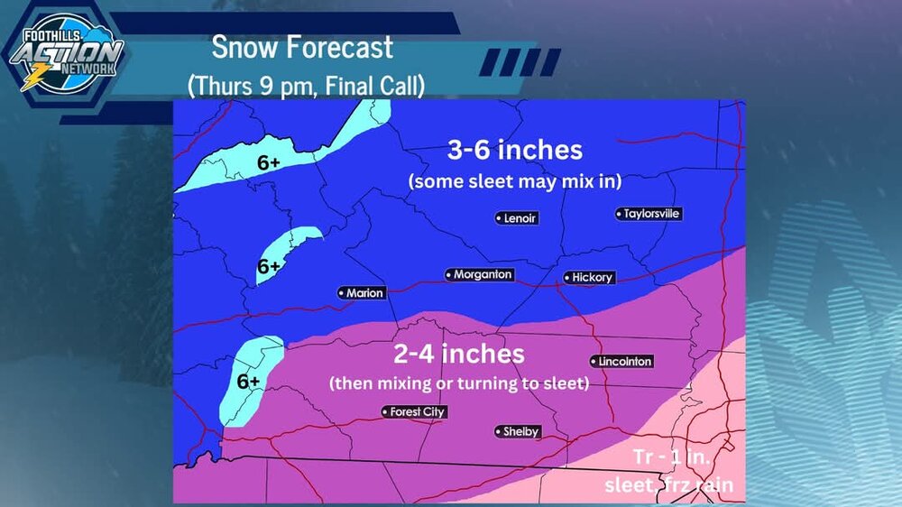
Foothills Weather network increased from 1-3 to 3-6 for most of I 40 north in WNC. If I can find their map I will share
-
Local Mets increasing totals now
-
Good trends fellas! I think Boone might be the big winner if they hey enough of the heavy rates
-
NAM and hires definitely trended colder. It was also very juiced up!
.thumb.png.0278ce5eab7ef2bbf6493af3db2fc1a9.png)
-
New NAM switches from snow to sleet back to snow for WNC mountains and northern foothills
-
NAM snow totals are still super ugly. I wonder what NWS will say
-
NAM slightly colder again but still more.amped than others
-
The thermals were mostly ok for us. Little bit less precipitation but still a solid look.
.thumb.png.2569ffb0ef75b43ad54ef4f2c59b797d.png)
-
Snow totals will be lower in WNC this run. Less moisture and warm nose more pronounced.
-
HRRR is coming in warmer mid levels with the sleet line about 50 miles north of 18Z so far


.png.8f877944c60f6a80e276d14f6ffd8b1e.png)
.png.8b917d0c808ceea98bc7cbe9622c5cd9.png)

.png.6b008911162c7f45238caf38bfb2351f.png)
.png.39b7a8c5a10bf6f6acbf2cb1a5dd8f5e.png)
.png.5cb51e95ec7944f169ff08087c31efb6.png)