MD Snow
-
Posts
1,875 -
Joined
-
Last visited
Content Type
Profiles
Blogs
Forums
American Weather
Media Demo
Store
Gallery
Everything posted by MD Snow
-
Jan 18-19 Storm Threat: Bob Chill made me do it
MD Snow replied to stormtracker's topic in Mid Atlantic
Shift north is in progress across guidance. Hard to deny. . -
Jan 15-16 Storm Threat Thread: Do we finally win or get Saltburned?
MD Snow replied to H2O's topic in Mid Atlantic
But the RGEM… .- 425 replies
-
- 1
-

-
- jinx
- kiss of death
- (and 3 more)
-
Jan Medium/Long Range Disco: Winter is coming
MD Snow replied to stormtracker's topic in Mid Atlantic
Haha…digital blue alert on the euro… . -
And yes, it's the Icon but it seems to be following the other globals last few runs of a slightly warmer more inland track...
-
March Medium/Long Range Thread: The Empire Strikes Back
MD Snow replied to stormtracker's topic in Mid Atlantic
Block seems slightly weaker. 50/50 is slightly easter. . -
March Medium/Long Range Thread: The Empire Strikes Back
MD Snow replied to stormtracker's topic in Mid Atlantic
It’s the ICON 5 days out… . -
March Medium/Long Range Thread: The Empire Strikes Back
MD Snow replied to stormtracker's topic in Mid Atlantic
Icon is interesting… . -
March Medium/Long Range Thread: The Empire Strikes Back
MD Snow replied to stormtracker's topic in Mid Atlantic
Yeah, really not that different in the grand scheme of things. Especially for a 5-6 day lead. -
March Medium/Long Range Thread: The Empire Strikes Back
MD Snow replied to stormtracker's topic in Mid Atlantic
Ugh…no icon on TT for the pregame warmup… . -
March Medium/Long Range Thread: The Empire Strikes Back
MD Snow replied to stormtracker's topic in Mid Atlantic
The theme all winter is for model's to pretty much lock into a general final solution from about 5 days or 120hrs out. Small wobbles here and there but general track etc pretty much set by that point. Given the blocking that's setting up and how this slow's the flow down a bit, I wouldn't be suprised if the general track is nailed down earlier than that for the 11-12th threat. So I'd imagine we've got another day or two of some crazy swings before the ops really start locking it in. -
March Medium/Long Range Thread: The Empire Strikes Back
MD Snow replied to stormtracker's topic in Mid Atlantic
8-9 days out guys… . -
March Medium/Long Range Thread: The Empire Strikes Back
MD Snow replied to stormtracker's topic in Mid Atlantic
Holy CMC at 198 . -
Totally agree with you. I understand what’s going on. I saw the eps. But like I said, given the trend to a cutter our only chance at seeing any wintry precipitation in this set up would be something on the front end imo. .
-
Front end dump is how we score in this set up. That’s what I’m tracking. .
-
I don’t know. Maybe just tightening the goal posts. .
-
Glad to be tracking a threat inside 6 days! That's a win for this winter. Thinking model's lock into a general track over the next 24 hrs. At that point, we start talking details. If we land on a general euro/cmc/icon solution and the low tracks to our south, it will be interesting to see how the block effects things in the final 96 hrs. Been fun to watch the tuesday storm get punched south over the last 48-72hrs. Looks like areas in southeast PA could even start as snow now, where a few days it was southern new york. Obviously, a gfs track dooms pretty much everyone. If we can avoid that cutter solution, I think there's a chance even the cities get into at least some accumulations.
-
Not sure if the storm has finished across all ens members by 144 on the eps? Some may start as rain and end as snow which may not be included in the snow map? .
-
Late February will be rocking. February Long range Discussion thread
MD Snow replied to Ji's topic in Mid Atlantic
CMC also shows a wave on the 22nd with temp issues along with a significant ice storm for Balt metro on the 24th. . -
Late February will be rocking. February Long range Discussion thread
MD Snow replied to Ji's topic in Mid Atlantic
The storm on the 23/24 and the chance of a front end thump. GFS, Euro and CMC all showing potential at this point. . -
Late February will be rocking. February Long range Discussion thread
MD Snow replied to Ji's topic in Mid Atlantic
CMC is pretty close as well. Major winter storm verbatim for the northern crew. I’ve been watching this window for a couple days now. GFS has been close a few times. Nice to see gfs and cmc move in the right direction tonight. -
Late February will be rocking. February Long range Discussion thread
MD Snow replied to Ji's topic in Mid Atlantic
Not liking a majority of LP's in VA/NC. Potential is there for the final shift to be inland today/tomorrow. -
Late February will be rocking. February Long range Discussion thread
MD Snow replied to Ji's topic in Mid Atlantic
Nice to see guidance possibly trending to something somewhat interesting inside of 5 days for once. . -
Late February will be rocking. February Long range Discussion thread
MD Snow replied to Ji's topic in Mid Atlantic
Well, the gfs just gave you 6+" with everything working out perfectly. So I guess it's not completely impossible for people with elevation. I know we're screwed regardless in the lowlands but hoping you can get a nice event at some point before middle of march. -
Late February will be rocking. February Long range Discussion thread
MD Snow replied to Ji's topic in Mid Atlantic
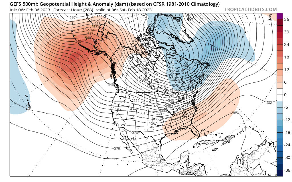
As it has been pointed out countless times, the only real way we're going to get snow this year will be by getting lucky or a fluke. Wave on the heels of a cold front, weak overrunning etc. Imo, our next chance of backing into a fluke event would after Feb 18 or so through the end of the month. Something to at least watch. May be our last shot of at least seeing flakes. The look below is supported by both the GEPS and EPS.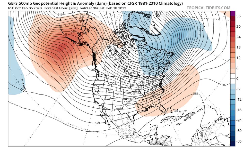
-
Late February will be rocking. February Long range Discussion thread
MD Snow replied to Ji's topic in Mid Atlantic
Living in the lowlands I’m well aware of my fate most winters. At this point, in this winter, I just want someone to score. I’m rooting for areas to the north and west to at least get one solid event. .