weatherfide
-
Posts
604 -
Joined
-
Last visited
Content Type
Profiles
Blogs
Forums
American Weather
Media Demo
Store
Gallery
Everything posted by weatherfide
-
-
 FV3, Euro, and to a lesser extent HRRR did well with this one. NAM is trash and I see why they want to eliminate it.
 -
I think i've got about 2" now! Snow keeps mixing back in to my sleet. Kids are going to try sledding the hill!
-
28.9, snowing and sleeting, about .75" so far.
-
Sleet accumulating here. Down to 30.9 with a wet bulb of 28.6.
-
Sleet accumulating here. Down to 30.9 with a wet bulb of 28.6.
-
Got moderate sleet here! 32.9. Dewpoint 19.3.
-
Icon is portraying a look I've seen so many times at my house. A sloppy rain/snow/sleet mix that changes to snow for a quick 1" to 1.5" of accumulations after sunset as it ends. Places just 30 miles north will have all snow and sleet all day and get 6" to 10".
-
There is a stout warm nose around 800 mb. The presence of this layer, if true, will ruin snow chances in many places in Georgia.
-
December 2024 Observations
weatherfide replied to WinstonSalemArlington's topic in Southeastern States
Reported a heavy frost and 33 degrees this morning. Currently 52.7 under clear skies. -
Mid to Long Range Discussion ~ 2024
weatherfide replied to buckeyefan1's topic in Southeastern States
Where can you go to get all of them? WeatherBell? -
Mid to Long Range Discussion ~ 2024
weatherfide replied to buckeyefan1's topic in Southeastern States
Interesting. I have pivotal access, too, and saw that image, but I'm not sure how it's deriving it. It might be all sleet and freezing rain in southern AL and SW GA. -
Mid to Long Range Discussion ~ 2024
weatherfide replied to buckeyefan1's topic in Southeastern States
I'm looking at the College of DuPage GEFS individual members and I'm not seeing the same results that you mention. Really not much showing up for the deep south at all. What source are you using for the GEFS member outputs? -
Mid to Long Range Discussion ~ 2024
weatherfide replied to buckeyefan1's topic in Southeastern States
GFS is world's different than ICON and GDPS. It looks like late March for most of the country. No cold, no ridge out west. If it's right, winter was indeed over last week. -
Mid to Long Range Discussion ~ 2024
weatherfide replied to buckeyefan1's topic in Southeastern States
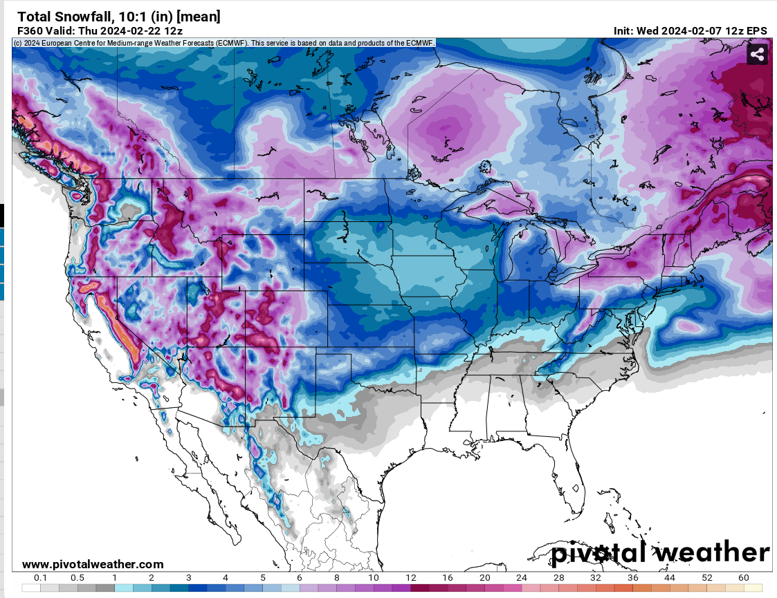
I really want to see the snowfall mean start to improve in GA, SC and NC on the EPS. We are entering the target zone and outside of a few big hitters, there aren't many members with snowfall outside of the mountains. The 12Z 2/7/2024 CMCE and GEFS were even worse than the EPS. II r
-
Mid to Long Range Discussion ~ 2024
weatherfide replied to buckeyefan1's topic in Southeastern States
Out to 240 hours or so on the GEFS. No individual members with snow in the southeast. I'll check in again tomorrow, but this is not encouraging if you want snow in the southeast. -
Mid to Long Range Discussion ~ 2024
weatherfide replied to buckeyefan1's topic in Southeastern States
That potential storm is well out in fantasy land. I'm waiting on the GEFS for some ideas, though the last few runs of the GEFS haven't had many members with much snowfall in the southeast. Usually the means have been skewed by one or two big snow outputs. -
Southeast Sanitarium - Winter 23/24 Edition
weatherfide replied to eyewall's topic in Southeastern States
Plus I really miss the dancing blue blob! -
Started out at 31.1 at my house this morning. Abundant frost. With the outlook continuing to present cold opportunities, this should help keep vulnerable plants asleep a little while longer in to Spring.
-
Southeast Sanitarium - Winter 23/24 Edition
weatherfide replied to eyewall's topic in Southeastern States
I think I'm coming back to Americanwx for awhile. Southernwx is getting weird, all high on hopium and not really grasping reality. -
Reached 39.7 here. Already below freezing at 31.1 and falling like a rock. No wind tonight. It's gonna be another cold one!
-
Southeast Sanitarium - Winter 23/24 Edition
weatherfide replied to eyewall's topic in Southeastern States
I thought only the far northwest part of GA was really in play from the start? There was a run or two from the GFS showing some snow further south but it was pretty lonely on that hill. -
I have 50 degrees and cloudy. Dewpoint is 44. If we get a little precipitation before the main line, it might drop down a bit more.
-
Looking at the winter outlooks, it would seem that this pattern will repeat with quite a bit of frequency this winter. I'm betting I can get by with one tank of propane, so there is a silver lining.
-
Southeast Sanitarium - A Place to Vent
weatherfide replied to Jonathan's topic in Southeastern States
I hate back-loaded winters. I rather have no winter.