
LovingGulfLows
-
Posts
761 -
Joined
-
Last visited
About LovingGulfLows

-
Southern Crippler - Get well soon Jimbo Storm Obs
LovingGulfLows replied to BooneWX's topic in Southeastern States
I mean farther north like Alpharetta/Cumming and east of there. -
Southern Crippler - Get well soon Jimbo Storm Obs
LovingGulfLows replied to BooneWX's topic in Southeastern States
Areas in the northern metro of ATL are reporting all sleet in the heavier banding....portends to good news for the Carolinas. -
Major Hurricane Melissa - 892mb - 185mph Jamaica landfall
LovingGulfLows replied to GaWx's topic in Tropical Headquarters
Intense based on this webcam from Treasure beach. -
That southerly moist fetch over PR is straight up nasty. I can't imagine what some of the final rain totals may look like.
-
Winter Storm Izzy Obs Thread
LovingGulfLows replied to Prismshine Productions's topic in Southeastern States
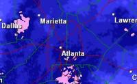
Snow breaking out all over metro Atlanta now. -
An ATL-based meteorologist suspects the backside of the system might overperform in AL/GA tomorrow.
-
High wind warning issued for N GA. https://twitter.com/iembot_ffc/status/1482455414084014080
-
Yup. That's what I've been banking on...honestly the comma head on the NAM is impressive in MS. They're getting pounded on.
-
It's interesting because the ICON also shows some backend snow for N GA(And Atlanta area) that's associated with the ULL overhead. I think it's possible Atlanta could see some backend snow as the ULL passes overhead. The more this thing digs, the higher the possibility that can happen. Temps at that point would be more than conductive for snow.
-
Front Range snowstorm nowcast/conditions 3/13-15
LovingGulfLows replied to mayjawintastawm's topic in Central/Western States
25 inches. They're most likely going to get between 30-36 inches. -
Front Range snowstorm nowcast/conditions 3/13-15
LovingGulfLows replied to mayjawintastawm's topic in Central/Western States
Looks like the NAM scored here. It had the main precip axis further north than other models. Cheyenne is going to shatter their all-time record. -
Light snow being reported in Cumming, GA(40 miles north of Atlanta). Bolds well for you guys in NE GA/Upstate SC/Piedmont NC.
-
Evidently it's snowing in Douglasville per this video:
-
Was Goni ever actually measured by an aircraft or was it just an estimate also? That storm could've also been over rated by satellite measurements.


