

mreaves
-
Posts
13,382 -
Joined
-
Last visited
Content Type
Profiles
Blogs
Forums
American Weather
Media Demo
Store
Gallery
Posts posted by mreaves
-
-
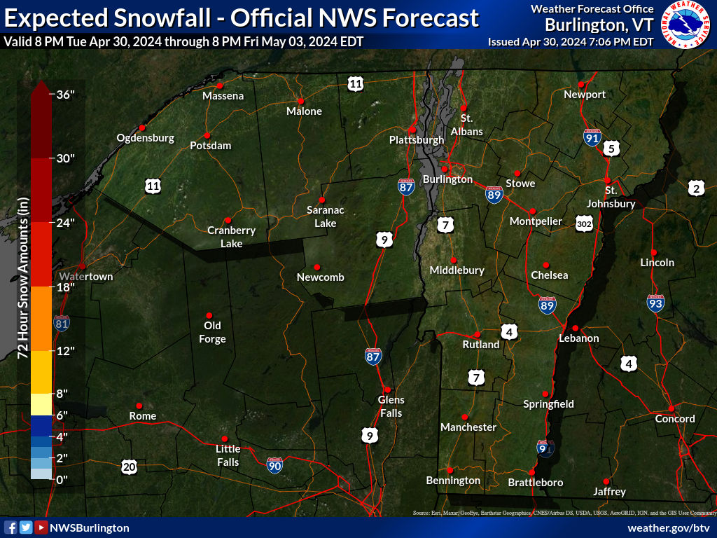
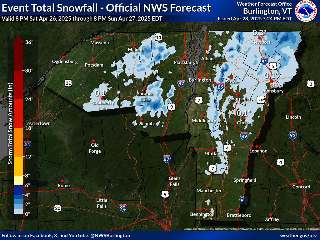
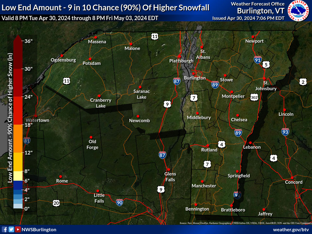
Latest map from BTV.

-
12 minutes ago, Zeppy said:
11.5" seems to have switched to a little of everything. 26.6
Are you in Bratt? I wonder what @Prismshine Productionsthinks about this. I’m not sure she’s had a storm like this.
-
7 minutes ago, ORH_wxman said:
Pretty solid icing on winter hill right now.
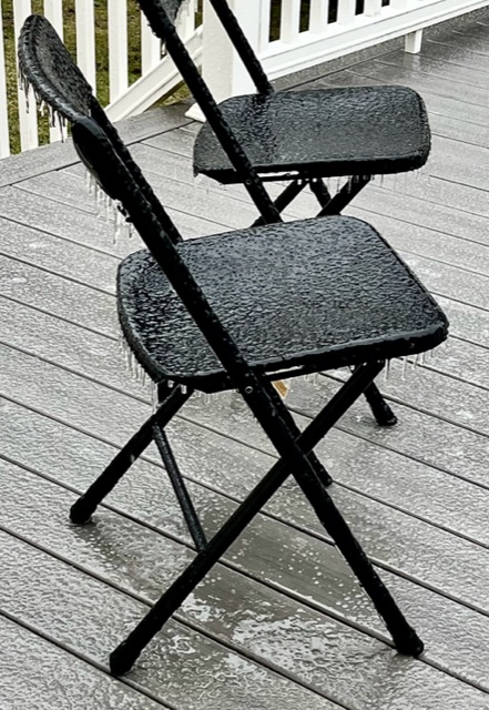
That’s some pretty fancy patio furniture to be leaving out in this weather.
-
 1
1
-
 3
3
-
-
6 minutes ago, powderfreak said:
About 4" so far eyeballing it.
Feels like BTV was a bit too aggressive with those >15” totals yesterday. I think you’re going to be closer with your 8”-14” call. Of course @klwis piling it up already so maybe the bigger totals are just a bit SE of me.
-
6 minutes ago, dmcginvt said:
cold and dry, the virga is real
Snowing decently here. Dewpoint up to 16°
-
1
-
-
BTV has been pretty consistent with amounts in this area.

-
27 minutes ago, FXWX said:
*** Here's a snippet from my late morning update to my Aubuchon Hardware Group across VT/NH/ME; an hour later I expanded concern into northern Mass...
11:35 AM FRIDAY, MARCH 22, 2024
HEAVY TO LOCALLY EXCESSIVE SNOW AND ICE ACCUMULATION POTENTIAL CONTINUES TO SEE INCREASED MODEL SUPPORT…
VERY CONCERNING TREE DAMAGE / POWER OUTAGE POTENTIAL IN PLAY FROM CENTRAL NY ON NORTH AND EAST ACROSS PORTIONS OF VT, NH AND INTERIOR MAINE…
Discussion: If anything, the outlook for widespread heavy to locally excessive snowfalls and ice accumulations has grown even more worrisome with almost universal model support. While I think the modeling may still be a bit over-blown, even if the totals are only 80% of reality, they still suggest a widespread damaging heavy snowfall and ice accumulation event late tonight and Saturday for many areas along and either side of the axis depicted on the snowfall map below. LONG DURATION OUTAGES A DISTINCT POSSIBILITY???
I like Aubuchon. Nice, regional chain. The one at the bottom of my hill has a Maine coon cat name Aubie.

-
6
-
-
1 minute ago, powderfreak said:
Thats aggressive.
I guess we should cheer them on.
-
3
-
-
BTV creeping us upward.
-
3
-
-
Just now, CoastalWx said:
Is it the type of station where you walk in, music stops, and everyone looks at you? I remember getting that look up in Errol, and then once when my buddy and I were up in the Forks area. I guess being 18 with a backwards RedSox hat did not go over with LL Bean and Carhatts being worn. The whole pub stared at us.
Yuppy wear.
-
1
-
 1
1
-
1
-
-
8 minutes ago, WinterWolf said:
Yup…Medway exit, Irving Gas station and mini market right off that exit.
It looks like he drove over 95.
-
1
-
-
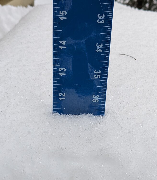
Hot off the presses from BTV. If I get the 15" shown, it will put me at 93" on the year.
-
2
-
-
9 minutes ago, 40/70 Benchmark said:
I was thinking to myself while taking the trash out late last night how I couldn't believe it was going to rain tomorrow night....the cold had a bite to it amid that "fresh" arctic aroma.
Sucks.
You sure that wasn't just the diapers in the trash?
-
2
-
-
29 minutes ago, Prismshine Productions said:
I got to get used to snow in March don't I...
Sent from my SM-S146VL using Tapatalk
In Brattleboro? Meh, not so much.
 J/K. We call that area the Banana Belt of VT.
-
1
-
-
9 minutes ago, CoastalWx said:
Well, once again, my envy turns to the north, but such as the way of the last couple of winters. If you guys get it, may there be widespread damage and outages for all.
Come on up, you can help me with snow removal. Think of it as one of those vacations that people from cities took in the 1800s to "work" on farms.
-
1
-
-
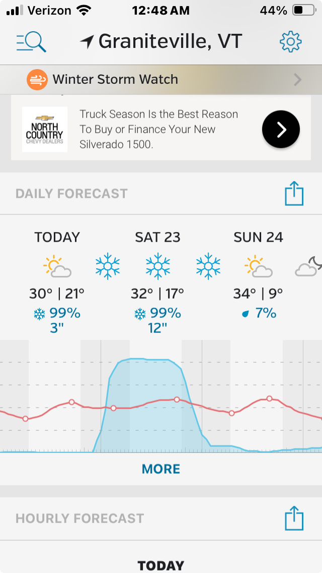
Wunderground is spitting out 15” Friday night and Saturday.
-
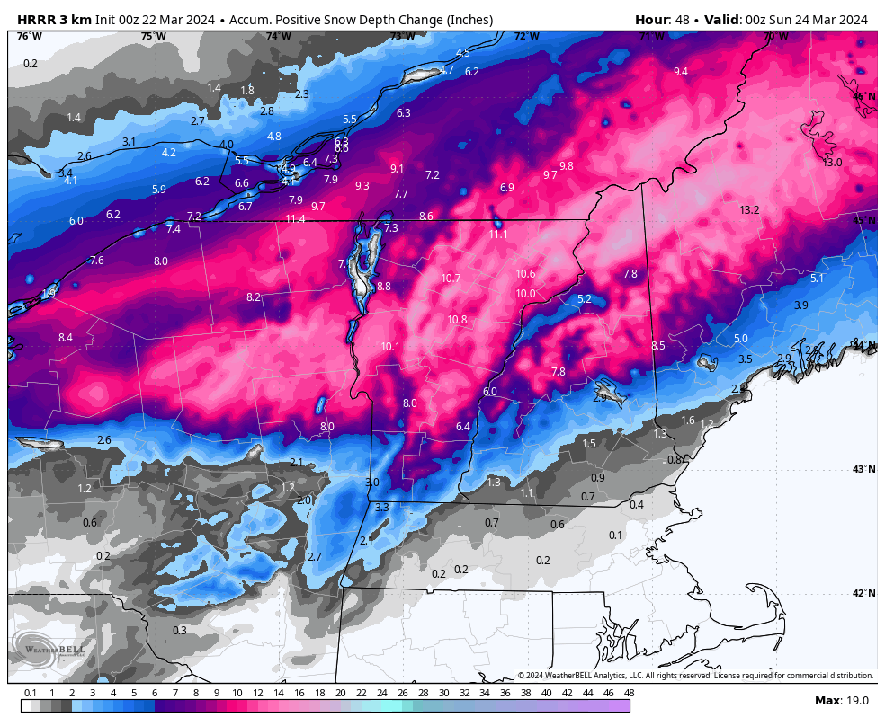
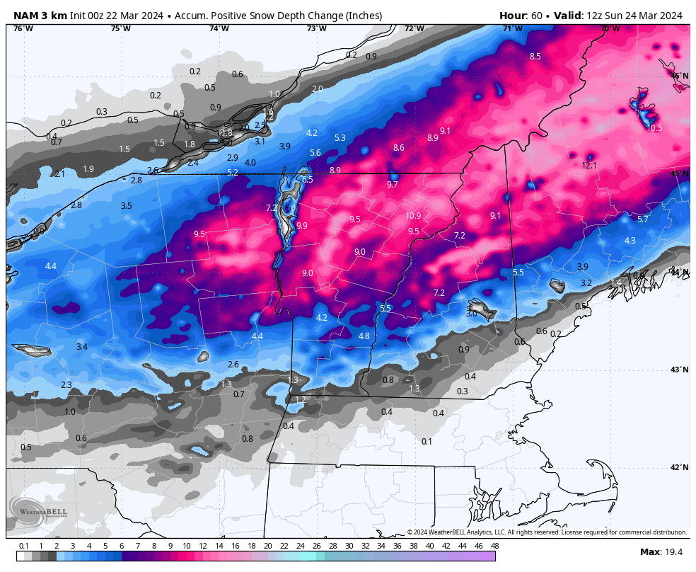
4 minutes ago, powderfreak said:
Agreed. 00z HRRR positive snow depth gains map.
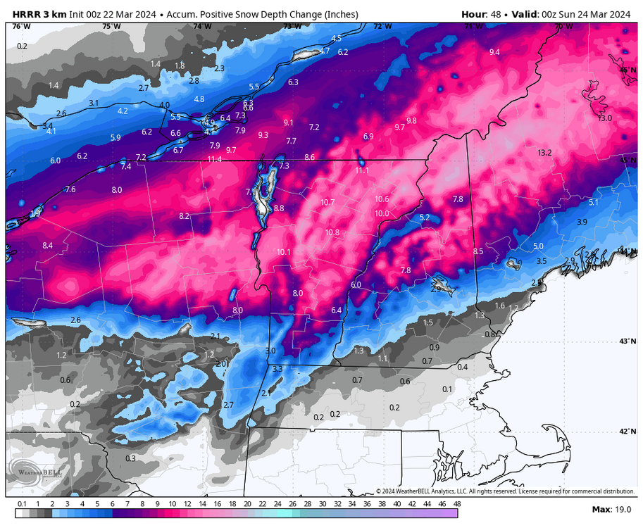
00z 3km NAM positive snow depth gains.

They both really screw Mitch. Lol
-
This thing is going to be a replay of almost every other storm we’ve had here this winter, 8”-10” of wet, heavy snow that’s a ball buster to clear.
-
1
-
-
18 minutes ago, powderfreak said:
I looked at the past 10 years the other day, it is a wild ride. From worst ever in 2015-16, to monster year in 2016-17… the variability is wild for measuring in the same place.
2014-15… 290”
2015-16… 156”
2016-17… 375”
2017-18… 264”
2018-19… 308” (*Under-reported due to snow reporting changes and misses.)
2019-20… COVID early closure, data incomplete.
2020-21… 218”
2021-22… 225”
2022-23… 221”
2023-24… 246” as of 3/21.2015-16 was worse in almost every way. There are more than 100 clubs grooming snowmobile trails across the state and I think there was less than 8000 miles groomed that year. The final numbers aren’t in yet for this year but it’s much more than that. It’s over 100,000 in a normal year. This year is probably more frustrating though.
-
1 hour ago, Ginx snewx said:
Govt shortages lol.
They ran out of helium because they had a big party and used it for party balloons
-
2 minutes ago, WinterWolf said:
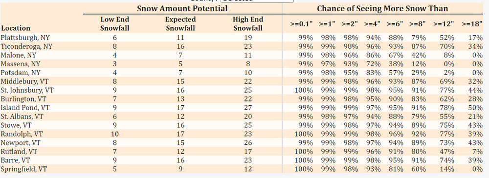
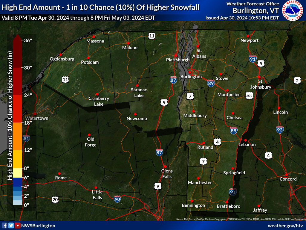
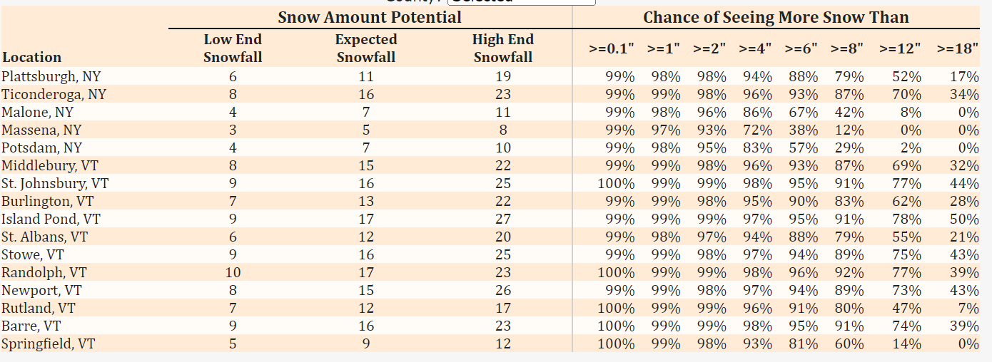
Maybe somebody could explain this to me…that 10% map says, 10% chance of higher snowfall. Is that higher snowfall than that map is showing(the 29” for Caribou)? I kind of read it as theirs only a 10% chance of that 29” occurring. But the wording says there’s a 10% chance of more than 29”’ lol.
I think its a 10% chance of verifying in the range with the maximum amount at specific locations but I'm the last person that should be attempting to explain that.
-
1
-
-
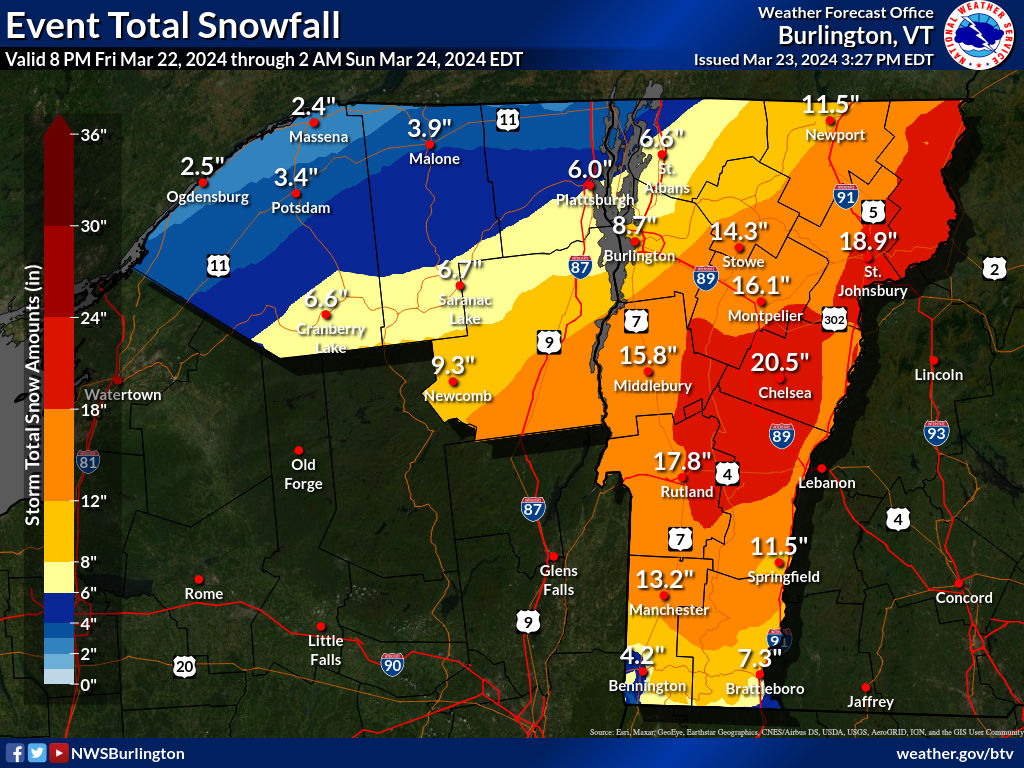
Here is the latest from BTV
-
BTV hitting the uncertainty
Concerningly
the latest ECMWF came in very wet (snowy) with storm total QPF
in the 1.7" to 2.4" range across most of Vermont, and about half
of its ensemble members do have greater than 2" in south
central Vermont. This dramatically wetter idea than other global
models may be tied a quicker development of a strong upper jet
Friday night, and subsequent phasing of the northern stream and
southern stream systems, leads to a deeper and more westward
coastal low track on Saturday. Given these differences, there
unsurprisingly is a large and unfortunately growing spread in
our low end and high end snowfall amounts; as an example,
Newport, VT, currently has a mostly likely amount of 8" with low
end of 3" and high end of 20". Part of the challenge,
especially farther south, will be snow ratio forecasts.

The snow ratios are rather uncertain similar to snow amounts when
you look at the spread amongst model guidance, particularly during
the daytime on Saturday. The interquartile range in the NBM snow
ratios in a swath from the Adirondacks eastward across central
Vermont is about 5:1 to 12:1. Obviously, the lower snow ratio end,
if it is all in the form of snow, would be a very wet snow.
Currently we are indicating a mix of rain and snow during the day in
the valleys locations in this region, which is why snow ratios are
even lower at times. Looking at forecast soundings in this area,
while strong upward motion will likely be co-located with the snow
growth zone, it will be located more than 10,000 feet above ground
while a nearly isothermal and relatively warm layer exists close to
the surface. Depending on how warm the boundary layer gets, it is
reasonable to expect snow character to indeed transition from
average to wet by Saturday morning. However, there then will be a
period of time late in the event that snow character should trend
drier, and the model spread greatly decreases Saturday evening with
a 10:1 or higher snow ratio favored. The question is how much liquid
will be fall in the wetter snow. Hopefully we can answer that
question as we get closer to the event to help predict snow load
impacts.
-
1 hour ago, bwt3650 said:
All the warm departures this year and that map gets us well past 300” for the year. Could actually manage average snowfall with nearly bare ground in December, January and early March..Crazy.
.If that map plays out, and I know it's not likely, it puts me just over 100". I don't have long term records but between the old KMPV obs and the average annual snowfall maps that BTV puts out is right at average. This would be the worst "average" year ever.

March 2024 disco/obs
in New England
Posted
Soooo, you’re saying I shouldn’t install?