

mreaves
-
Posts
13,364 -
Joined
-
Last visited
Content Type
Profiles
Blogs
Forums
American Weather
Media Demo
Store
Gallery
Posts posted by mreaves
-
-
22 minutes ago, timp said:
9” here. 110” on the season now. Pretty damn good for all the warmth lol.
Nice. The 6.5" I've gotten so far puts me at 98.75". Maybe I can eek out a little more to get to the century mark.
-
 1
1
-
-
8 minutes ago, Professional Lurker said:
Just confirmed my reservations in Magog, QC. 3:28 in darkness, weather still looks good. About 10 miles from the centerline. Looks like a pretty cool little town. Anybody ever been?
Sent from my Pixel 7 using Tapatalk
Sort of? About 35 years ago some friends of mine rented a camp on Joe's Pond in Danville, VT. We were up there on Friday night doing what 21 year olds do on Friday nights and someone says "Canada isn't that far, let's go!" We piled into a couple of cars and hit I-91 north. It's actually 55 miles to the border crossing and then there isn't really anything just over the boarder so we kept going another 25 miles until we hit Magog. Seemed like a nice enough town but couldn't really see much at 1:30 in the morning. I've driven through the area since but haven't really been back to the town.
-
1
-
-
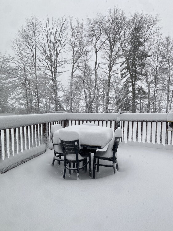
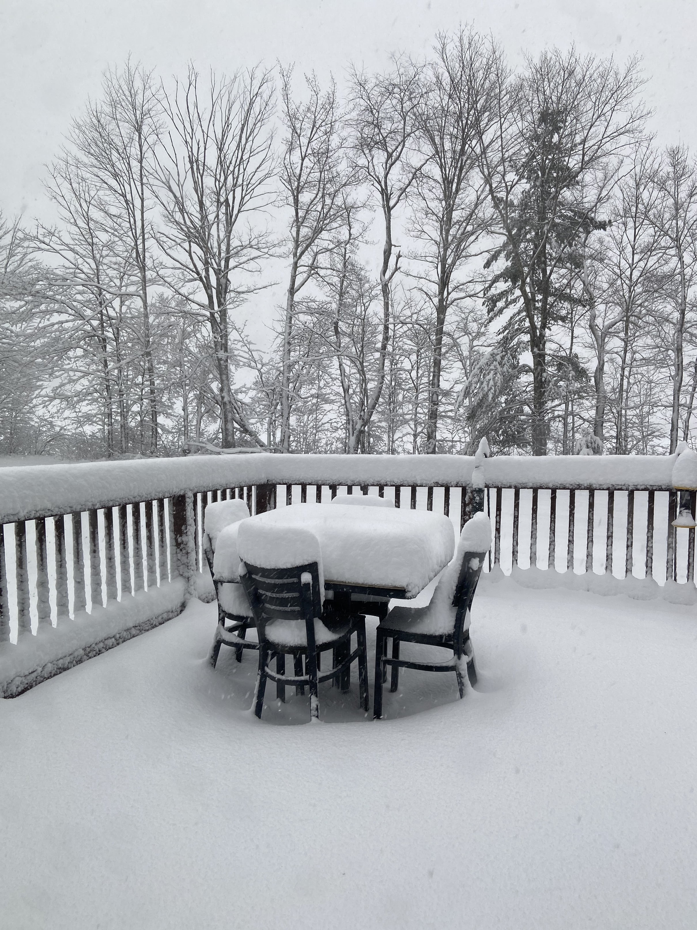
4.5" overnight, 6.5" total. Still lightly snowing small flakes/grains. 29.4°
-
1
-
-
4.5" overnight, 6.5" total. Still lightly snowing small flakes/grains. 29.4°
-
35 minutes ago, mreaves said:
I haven’t gone out to measure yet so I may not actually be ahead. That was my guesstimate.
Official board clearing measurement of 2.0” on the dot. Wind is loud in the trees and snow is light.
-
1
-
-
Just now, EMontpelierWhiteout said:
You’re a little ahead if me. Maybe 1.5” but heavy snow now.
I haven’t gone out to measure yet so I may not actually be ahead. That was my guesstimate.
-
Eyeballing about 2”. 31.6°
-
1
-
-
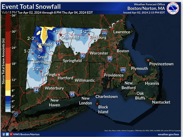
I was hoping to be able to make fun of the GYX onset map but they seem to be a bit more subdued.
-
 1
1
-
-
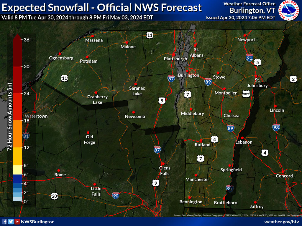
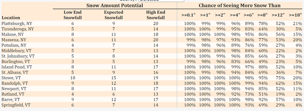
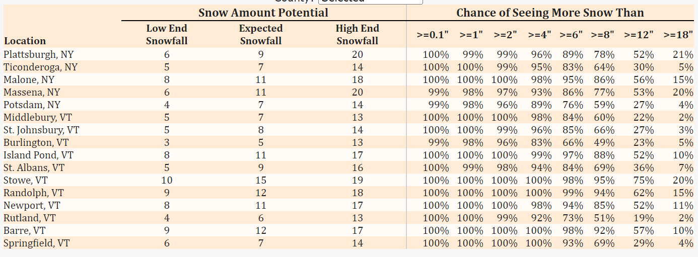
53 minutes ago, dryslot said:
A bit easier reading the colors on this map.........

BTV uses those colors too.
-
1
-
-
6 minutes ago, tunafish said:
Before we get any real obs going...for the love of god, throw out a white piece of wood or even a cutting board for your snow measurements.
Pains me to see deck railing and driveway measurements (cough cough astro' 'joyer)
Joe blow on facebook? fine, whatever. You weenies? For shame.
It’s hard to see but this is my PWS set up. I mounted it on a white board off the corner of my deck using shelving brackets. It’s 7’-8’ off the ground. It’s not perfect but does a decent job. I also have an NWS employee who lives not far from me and I check my measurements with what they report when the PNS comes out. Usually within about a half inch either way.
-
1
-
-
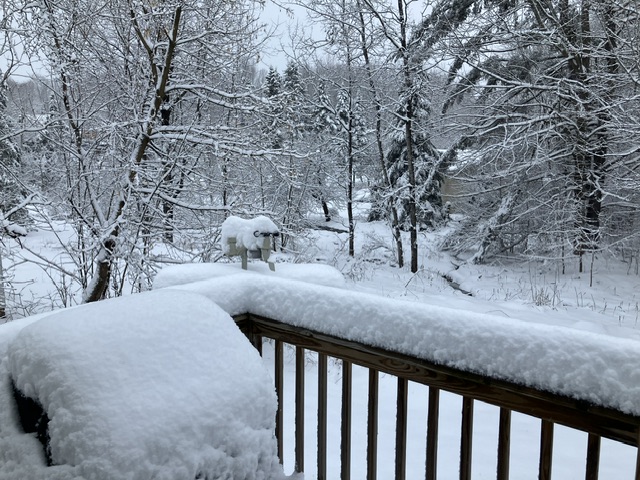
BTV had things starting between 6:00 and 8:00pm. Looked out the window for what appeared to be the first few flakes and then it ramped up to something between light and moderate.
-
Latest from BTV
-
11 minutes ago, Torch Tiger said:
anyone want to comment about the storm?
Yes, I don’t want any of it. I’m not expecting my opinion to actually impact anything.
-
1
-
2
-
-
21 minutes ago, weatherwiz said:
60% of the time I go conservative every time
Yogi Berra speaks! (Fellow old guys will get that)
-
1
-
3
-
-
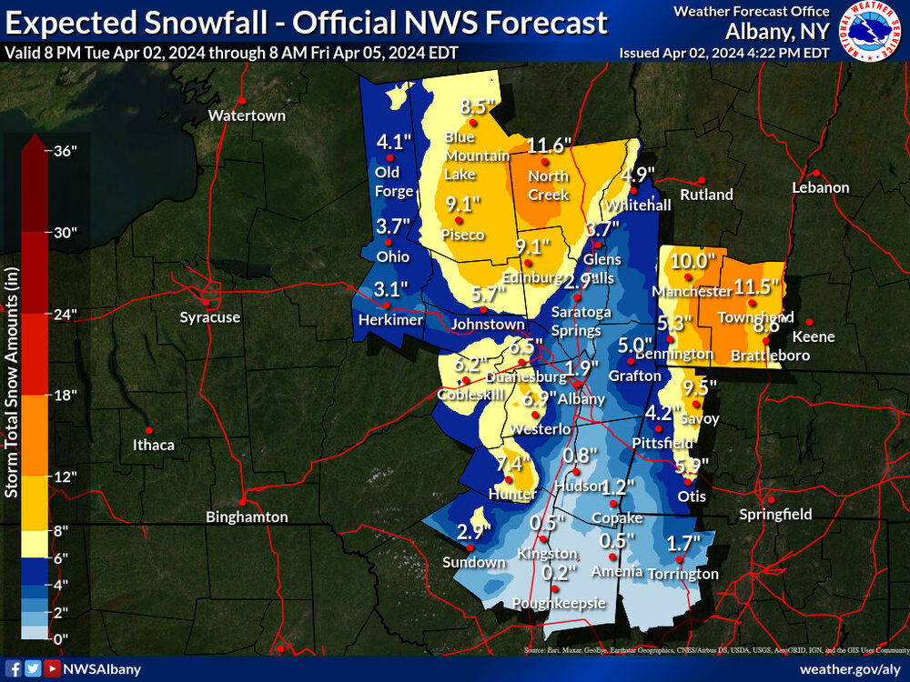
1 hour ago, HIPPYVALLEY said:
More realistic too…
This is ALY’s latest.
-
1 minute ago, mreaves said:
Bennington and Windham counties are ALY territory so I don't know if that is the actual BTV forecast or they pilfered it from ALY.
Of course I could just look it up.
BTV's map is more recent.
-
6 minutes ago, HIPPYVALLEY said:
Somebody’s going to be way off.
Bennington and Windham counties are ALY territory so I don't know if that is the actual BTV forecast or they pilfered it from ALY.
-
12 minutes ago, HIPPYVALLEY said:
BOX not impressed.
Burlington more bullish.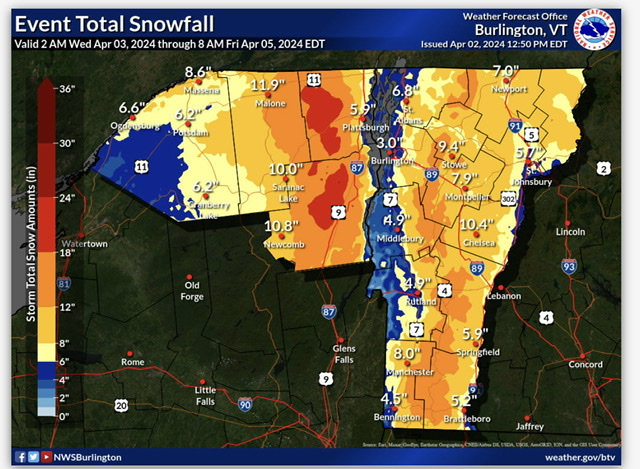
BTV is even more bullish now.
-
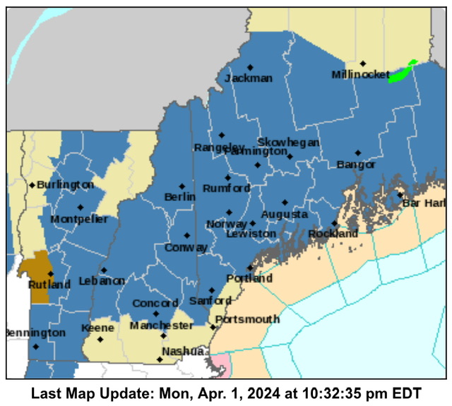
Warnings up here too.
URGENT - WINTER WEATHER MESSAGE
National Weather Service Burlington VT
327 PM EDT Tue Apr 2 2024

NYZ030-031-034-VTZ003-006-008-010-016>021-030900-
/O.UPG.KBTV.WS.A.0005.240403T1200Z-240405T1000Z/
/O.NEW.KBTV.WS.W.0007.240403T1500Z-240405T1000Z/
Southern Franklin-Western Clinton-Western Essex-Orleans-Lamoille-
Washington-Orange-Eastern Franklin-Eastern Chittenden-
Eastern Addison-Eastern Rutland-Western Windsor-Eastern Windsor-
Including the cities of Saranac Lake, Tupper Lake, Dannemora,
Ellenburg, Lake Placid, Newcomb, Derby, Newport, Johnson, Stowe,
Montpelier, Waitsfield, Bradford, Randolph, Enosburg Falls,
Richford, Richmond, Underhill, Bristol, Ripton, East Wallingford,
Killington, Bethel, Ludlow, Springfield, and White River Junction
327 PM EDT Tue Apr 2 2024

...WINTER STORM WARNING IN EFFECT FROM 11 AM WEDNESDAY TO 6 AM
EDT FRIDAY...

* WHAT...Heavy, elevation dependent snow expected. Total snow
  accumulations of 7 to 20 inches. Winds gusting as high as 60 mph
  along western slopes of the southern Greens prior to heavy snow
  Wednesday evening.

* WHERE...Portions of northern New York and central, northeast,
  northwest and southern Vermont.

* WHEN...From 11 AM Wednesday to 6 AM EDT Friday.

* IMPACTS...Travel could be very difficult. Travel on mountain
  passes may be impossible. The hazardous conditions is most
  likely to impact the Thursday morning commute. Strong winds
  could cause tree damage.

* ADDITIONAL DETAILS...The heaviest snow is likely to occur
  Wednesday night into Thursday. In the afternoon, snow
  accumulations are more likely on grassy surfaces and elevated
  terrain than on roadways.

PRECAUTIONARY/PREPAREDNESS ACTIONS...

If you must travel, keep an extra flashlight, food, and water in
your vehicle in case of an emergency.

Please allow extra time if travel is necessary.

&&
-
Where has pickles been? You would figure he would chase somewhere in the Monadnocks.
-
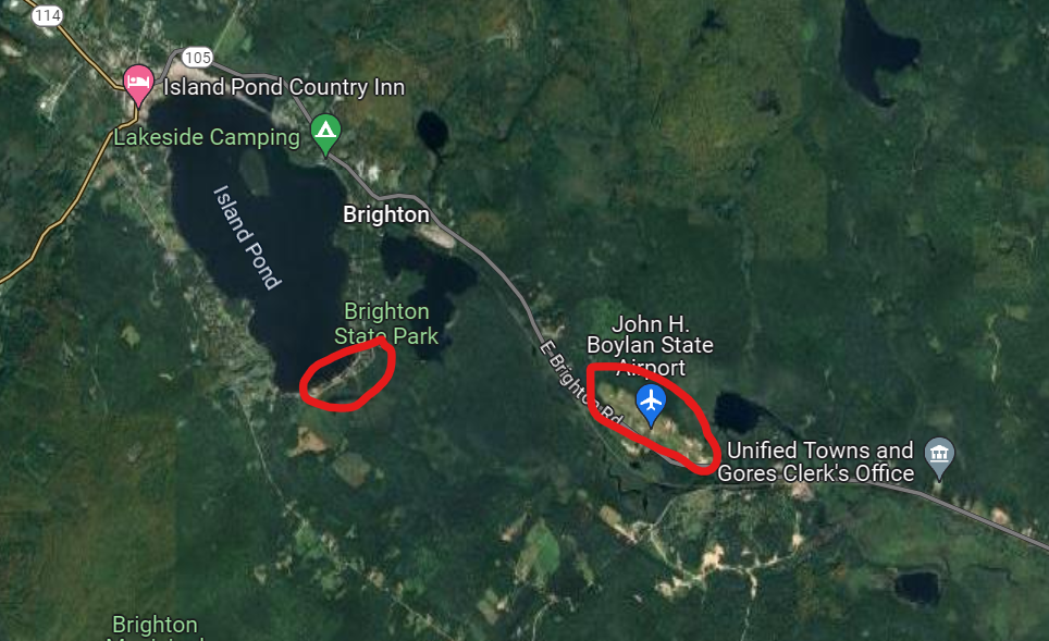
1 hour ago, mreaves said:
I think it will be busy. The town isn't very big. There are a couple of hotels and restaurants in town but not a lot else. I think the best place to be might be the State Park and beach on the other side of the lake or the airport. I've circled both in red below.
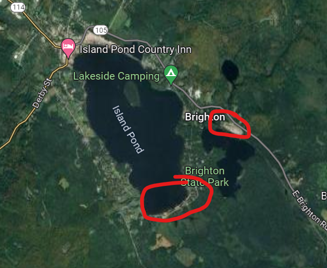
I circled the wrong spot for the airport. Corrected below.
-
 1
1
-
-
48 minutes ago, NoCORH4L said:
Think Island Pond/Brighton will be busy? Staying at the camp which is a 2 hour drive to there, but I don't want to deal with 93 and the notch, then a slog up to Colebrook. I have a feeling that's where everyone in MA is heading.
I think it will be busy. The town isn't very big. There are a couple of hotels and restaurants in town but not a lot else. I think the best place to be might be the State Park and beach on the other side of the lake or the airport. I've circled both in red below.
-
1
-
-
33 minutes ago, powderfreak said:
Could see the Watches extended into your area for sure.
Wow. Must be expecting the NEK to be completely shadowed.
-
1 hour ago, Damage In Tolland said:
Well you do have an iPhone 4s.. so that may have something to do with it
He's upgraded? I thought he still had one of these.
-
4
-


Significant Miller B Nor'easter Apr 3rd-4th OBS
in New England
Posted
17,485 out here.