

mreaves
-
Posts
13,366 -
Joined
-
Last visited
Content Type
Profiles
Blogs
Forums
American Weather
Media Demo
Store
Gallery
Posts posted by mreaves
-
-
1 hour ago, Damage In Tolland said:
Well you do have an iPhone 4s.. so that may have something to do with it
He's upgraded? I thought he still had one of these.
-
 4
4
-
-
-
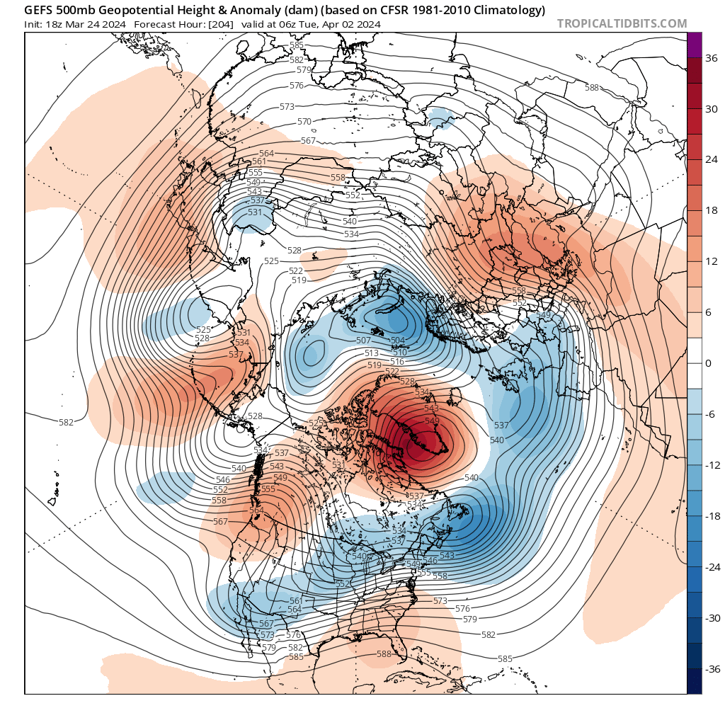
@J.Spin BTV posted a new map
-
-
Just now, dryslot said:
URGENT - WINTER WEATHER MESSAGE
National Weather Service Gray ME
Issued by National Weather Service Caribou ME
351 PM EDT Mon Apr 1 2024

MEZ007-008-012-013-018>021-024>026-033-020800-
/O.NEW.KGYX.WS.A.0008.240403T1800Z-240405T1000Z/
Northern Oxford-Northern Franklin-Southern Oxford-Southern
Franklin-Interior York-Central Interior Cumberland-Androscoggin-
Kennebec-Coastal Cumberland-Sagadahoc-Lincoln-Interior Cumberland
Highlands-
Including the cities of Gray, Bethel, North Windham, Oquossoc,
Windsor, Berwick, Gorham, Boothbay Harbor, Milton, Alna,
Farmington, Hanover, Alfred, Wilton, Bowdoinham, Sidney, Roxbury,
Goodwins Mills, Coburn Gore, Bridgton, New Vineyard, Greene,
Wiscasset, Phillips, South Portland, Limington, Newcastle,
Vassalboro, Norway, New Gloucester, Middle Dam, Fryeburg, Avon,
Harrison, Rangeley, China, Westbrook, Upton, Bristol, Bath,
Naples, Sabattus, Dresden, Davis, Newry, Lebanon, Temple, Buxton,
Kingfield, Waterville, Whitefield, Topsham, Damariscotta,
Yarmouth, Waldoboro, Turner, Sanford, Lewiston, Hollis, Livermore
Falls, Oxford, Portland, Bryant Pond, South Arm, Bowdoin,
Chesterville, Wales, Jay, Augusta, Phippsburg, Byron, Palermo,
Locke Mills, Minot, Cape Elizabeth, Bremen, Wilsons Mills,
Andover, New Sharon, Rumford, Brunswick, Auburn, and Arrowsic
351 PM EDT Mon Apr 1 2024

...WINTER STORM WATCH IN EFFECT FROM WEDNESDAY AFTERNOON THROUGH
LATE THURSDAY NIGHT...

* WHAT...Heavy snow possible. Total snow accumulations greater than
  18 inches possible. Winds could gust as high as 55 mph.

* WHERE...Portions of south central, southwest, and western Maine.

* WHEN...From Wednesday afternoon through late Thursday night.

* IMPACTS...Visibilities may drop below 1/4 mile due to falling and
  blowing snow. The strong winds and weight of snow on tree limbs
  may down power lines and could cause scattered to numerous power
  outages. Significant snowfall and periods of heavy snowfall rates
  will combine with low visibility to create very dangerous driving
  conditions. The hazardous conditions could impact the Wednesday
  evening and Thursday morning commutes. Gusty winds could bring
  down tree branches.

PRECAUTIONARY/PREPAREDNESS ACTIONS...

Monitor the latest forecasts for updates on this situation.

&&
Might as well add BTV's
URGENT - WINTER WEATHER MESSAGE
National Weather Service Burlington VT
329 PM EDT Mon Apr 1 2024

NYZ029>031-034-VTZ003-006-008-010-016>021-020900-
/O.NEW.KBTV.WS.A.0005.240403T1200Z-240405T1000Z/
Southeastern St. Lawrence-Southern Franklin-Western Clinton-
Western Essex-Orleans-Lamoille-Washington-Orange-Eastern Franklin-
Eastern Chittenden-Eastern Addison-Eastern Rutland-
Western Windsor-Eastern Windsor-
Including the cities of South Colton, Star Lake, Saranac Lake,
Tupper Lake, Dannemora, Ellenburg, Lake Placid, Newcomb, Derby,
Newport, Johnson, Stowe, Montpelier, Waitsfield, Bradford,
Randolph, Enosburg Falls, Richford, Richmond, Underhill, Bristol,
Ripton, East Wallingford, Killington, Bethel, Ludlow,
Springfield, and White River Junction
329 PM EDT Mon Apr 1 2024

...WINTER STORM WATCH IN EFFECT FROM WEDNESDAY MORNING THROUGH
LATE THURSDAY NIGHT...

* WHAT...Heavy snow possible and mixed precipitation. Total snow
  accumulations of 6 to 14 inches possible and a hundredth of flat
  ice. Easterly winds could gust as high as 50 mph along west
  slopes of the Green Mountains.

* WHERE...Portions of northern New York and central, northeast,
  northwest and southern Vermont.

* WHEN...From Wednesday morning through late Thursday night.

* IMPACTS...Travel could be very difficult. The hazardous
  conditions could impact the Wednesday evening commute and
  Thursday morning commute. Gusty winds could bring down tree
  branches. Scattered power outages are possible.

* ADDITIONAL DETAILS...Snow is likely to be wet in nature. The
  potential for snowloading may increase the risk for power
  outages.

PRECAUTIONARY/PREPAREDNESS ACTIONS...

Monitor the latest forecasts for updates on this situation.

&&

$$

For more information from the National Weather Service visit
http://weather.gov/btv/winter
-
 2
2
-
-
25 minutes ago, powderfreak said:
There’s a decent NNE contingency, I feel like it’s stronger than it has been in past years with a couple of the new posters too. But post count has dropped quite a lot since those Dec 1992 runs.
I think you’re right but some of us are checked out, well, I am. I’m ready for golf.
-
5 hours ago, HoarfrostHubb said:
I am not buying the GFS. But not sold on the Euro either. And def not the CMC.
You going JMA and ICON?
-
1
-
-
1 hour ago, DavisStraight said:
Why travel, just set up some chairs in your backyard and get a case a beer.
I guess I just want to make sure I experience totality. That was my first thought but then I started looking closely and noticed how close I was.
-
19 minutes ago, wxeyeNH said:
Since I live in the Plymouth NH area I know the backroads pretty well. Take 93 up to Plymouth. Get off and go west on Rt 25. Head up on the NH side of the Connecticut River. Then take one of the bridges over to Rt 5 or Rt 91 into the St Johnsbury area. Then decide how far north or west you want to go to get into a longer and darker eclipse. This will be a darker eclipse vs 2017 as the path of totality is wider. Unfortunately for travelers the center line is near Canada. On the edge of totality is interesting however as the Diamond Ring and Bailey's Beads last much longer. As I say over and over. A 99% partial and a 100% total is like the difference between kissing someone and marrying them. Oh, another idea. There are lots of small businesses in the path of totality. Pick where you want to go and call one of them in advance. Ask if you can park in their lot and tell them you are even willing to throw them a few bucks their way. Or bring them a small gift, like a couple of 6 packs of beer. With that in mind they might let you use their bathrooms as potty break as bathrooms and gas are going to be hard to find. This is all weather dependant of course.
The edge of totality is almost literally over my head. I’m not sure how far NW I’ll drive to get into it.
-
1
-
-
38 minutes ago, NW_of_GYX said:
Ya it’s a much different system than last weekends. If I had to guess I’d say the winners will be further south than the last one
36 minutes ago, dryslot said:I agree.
Oh how we pray.
-
1
-
-
I don’t know a lot about ski area operations but I bet they looked at how much money they make early vs April. No excuse for the lack of communication though.
-
1
-
-
2 hours ago, 40/70 Benchmark said:
Wow.....

@AstronomyEnjoyer ‘s barn gets crushed before he’s finished building it.
-
6
-
 1
1
-
-
2 minutes ago, dryslot said:
Somebody is going to get a blockbuster.
I'm hoping for the big south trend. I'd love to be smoking cirrus for this one.
-
2 hours ago, Damage In Tolland said:
Good news is after that storm next week all guidance has big pig east coast ridge and warmth . Would be early taste of summer for a few days and timed perfectly for the eclipse.
Boy it would be nice if you were correct for once.
-
2
-
 1
1
-
4
-
-
39 minutes ago, powderfreak said:
These temps sort of sum up the entire winter. And are what we see for the next week or two.
But we were told that spring in New England is usually pleasant now.
-
1
-
-
1 hour ago, HoarfrostHubb said:
Will it ever stop raining?
-
Just now, Cold Miser said:
The new reality.
Winter is now just a side dish, not even a season anymore.Deal with it.
Thank you LC.
-
1
-
-
1 hour ago, CoastalWx said:
Until then it’s this.
-
2
-
-
3 hours ago, Brewbeer said:
I thought about bringing a 5 gallon gas can too, but probably just going to fill up about an hour before arriving, maybe in Bradford or Woodville.
If you’re on 91, P&H Truckstop in Wells River might be the easiest to access. Great homemade bread and other baked goods too.
-
12 minutes ago, MJO812 said:
Caribou is close to 90 inches
I’m over 90”
-
2
-
-
2 hours ago, dryslot said:
To many obstacles to navigate after the warmth the first part of the month, I'm done no matter if anything else falls, Not many clubs still grooming here.
We had a few that went out. I might have gone if I hadn’t had to work but couldn’t get out of the meetings I had today.
-
1 minute ago, dryslot said:
Yes, Month to late, No use now unless you ski.
The trails that got opened here were mobbed, yesterday and today. Of course I couldn’t go either day. Typical.
-
1
-
-
9 minutes ago, Typhoon Tip said:
Not sure of the significance when weighting into this particular model conflict today, but the Euro was also 'whiffy' with the last event and didn't conceded until it was 3 or 4 days out -
fwiw
Or in layman’s terms:
5 minutes ago, WinterWolf said:Euro has been glue factory worthy this year…it’ll cave.
-
3
-
-
34 minutes ago, Typhoon Tip said:
It may or may not snow again aside
… this is a box of grade A powdered butt f* New England spring, just add water
I’ve been told that NE springs are generally nice and warm.
-
1
-
3
-
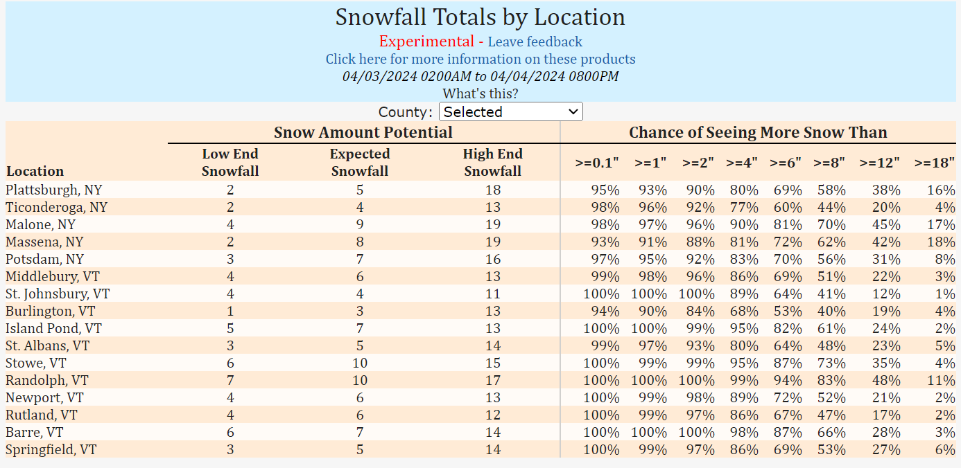
Significant Miller B Nor'easter watch, Apr 3rd-4th
in New England
Posted
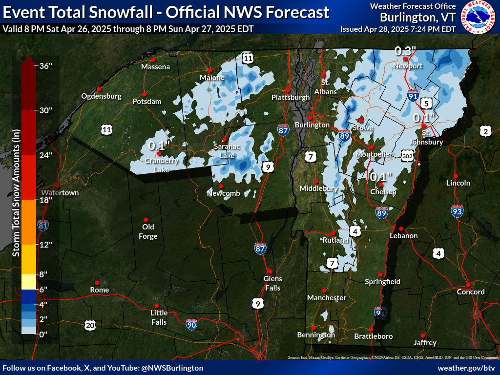
Wow. Must be expecting the NEK to be completely shadowed.