

Tatamy
-
Posts
2,028 -
Joined
-
Last visited
Content Type
Profiles
Blogs
Forums
American Weather
Media Demo
Store
Gallery
Posts posted by Tatamy
-
-
1 hour ago, forkyfork said:
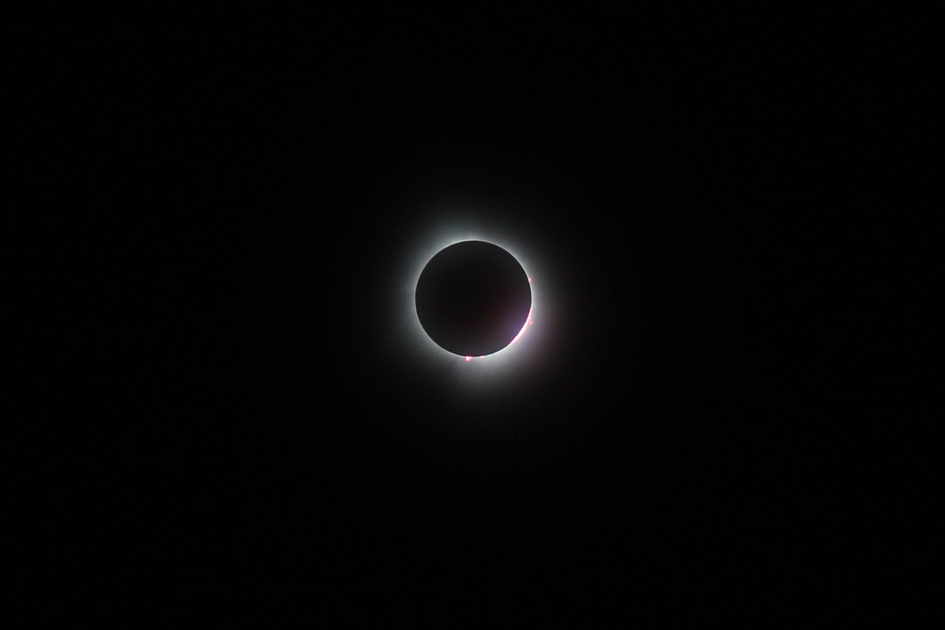
You got the flare! Well done. That’s what I saw however I could not get the shot.
-
 1
1
-
-
Incredible experience. The clouds parted just enough so we could get the totality experience. I even saw a bright orange solar flare. Amazing!!
-
2
-
-
1 hour ago, LibertyBell said:
Nice pictures, be sure to take pictures of the different stages of the eclipse, Lake George to Lake Champlain may be in high clouds but it doesn't mean you won't see totality.
Looks like there are people still enroute from the Albany who are hitting traffic on 87. The folks traveling north in VT and NH are in a mess with major back ups on the interstates there.
-
1
-
-
12 minutes ago, LibertyBell said:
How far from Watertown?
40 miles south.
-
2
-
-
On the SE corner of Lake Ontario near Mexico, NY. Just some patchy cirrus around. Not a whole lot of people out and about here.
-
1
-
-
Staying overnight in Binghamton. Will plan my next move up there based on hi res model outputs. The AFDs that I read speak of a cirrus deck and a mid-level deck. The hi res outputs are showing breaks in this cloud shield. Hopefully I can identify a suitable area north of Syracuse where one of these breaks happen. It’s definitely a crap shoot. What is really interesting is that hotels and other places up there that have been fully booked all week have rooms available for tonight (not cheap). In any case not feeling the love about driving all the way up to northern VT.
-
1
-
-
11 minutes ago, nycwinter said:
wind been howling for a few hours now...
Same here all day.
-
Still on and off rain here. My storm total since Monday is 3.08”
-
1
-
-
9 minutes ago, JetsPens87 said:
Strong jet overhead. Mostly taking stronger bursts of rain to bring it down though. It's sitting RIGHT near the inversion.
You’re not kidding. I am seeing lightning strikes being registered on my Tempest station as this latest batch comes through.
-
6 minutes ago, RedSky said:
The wind from the wake low is reeking havoc here. Siding off houses etc.
I am hearing this unearthly roar in the sky with these winds.
-
1
-
-
17 minutes ago, Tatamy said:
Mt. Holly has issued a special weather statement for a wake low which is producing strong winds to 40 - 50 mph across eastern PA and northern NJ. This is going to be incoming for you in the NYC area.
Special Weather Statement
National Weather Service Mount Holly NJ
1238 PM EDT Wed Apr 3 2024

NJZ001-007>009-PAZ054-055-060>062-101-103-105-031745-
Sussex-Warren-Morris-Hunterdon-Carbon-Monroe-Berks-Lehigh-
Northampton-Western Chester-Western Montgomery-Upper Bucks-
Including the cities of Newton, Washington, Morristown,
Flemington, Jim Thorpe, Stroudsburg, Reading, Allentown,
Bethlehem, Easton, Honey Brook, Oxford, Collegeville, Pottstown,
Chalfont, and Perkasie
1238 PM EDT Wed Apr 3 2024

...Strong Wind Gusts with a Passing Wake Low Early this
Afternoon...

Isolated strong easterly wind gusts near 40 to 50 mph have
developed on the back side of the ending heavy rainfall early this
afternoon. This is in response to a wake low passing across the
area. These wind gusts may result in some isolated instances of
tree damage or power outages. Use caution and take shelter indoors
if sudden strong wind gusts develop in your area.

$$

Staarmann
Recent gust to 35 mph at my inland location with this feature. I suspect you who are in the NYC area will really see your winds crank as this feature comes through.
-
Mt. Holly has issued a special weather statement for a wake low which is producing strong winds to 40 - 50 mph across eastern PA and northern NJ. This is going to be incoming for you in the NYC area.
Special Weather Statement
National Weather Service Mount Holly NJ
1238 PM EDT Wed Apr 3 2024

NJZ001-007>009-PAZ054-055-060>062-101-103-105-031745-
Sussex-Warren-Morris-Hunterdon-Carbon-Monroe-Berks-Lehigh-
Northampton-Western Chester-Western Montgomery-Upper Bucks-
Including the cities of Newton, Washington, Morristown,
Flemington, Jim Thorpe, Stroudsburg, Reading, Allentown,
Bethlehem, Easton, Honey Brook, Oxford, Collegeville, Pottstown,
Chalfont, and Perkasie
1238 PM EDT Wed Apr 3 2024

...Strong Wind Gusts with a Passing Wake Low Early this
Afternoon...

Isolated strong easterly wind gusts near 40 to 50 mph have
developed on the back side of the ending heavy rainfall early this
afternoon. This is in response to a wake low passing across the
area. These wind gusts may result in some isolated instances of
tree damage or power outages. Use caution and take shelter indoors
if sudden strong wind gusts develop in your area.

$$

Staarmann
-
6
-
-
2 minutes ago, jm1220 said:
Looking pretty likely Boston ends under 10” for the winter which is absolute basement level disaster. Even I had 15.5” this season. If you take the last 4 winters from 20-21 on it’s been about as good here on the LI N Shore as it’s been there-and of course the last 2 winters have been complete trash. 21-22 was better there but 20-21 better here.
Looking quite dicey on the coastal flood threat tomorrow AM, major flood predicted in Freeport and moderate to major almost everywhere else on the S Shore bays. That plus maybe 2” more rain will means lots more flooding everywhere. Power might be out/trees down as well if these 60 mph gusts happen on saturated ground.
I have had 25” for this season so it’s a C+ for me. Been a tough season for a lot of places.
-
1
-
-
13 minutes ago, MJO812 said:
Snow depth maps are awful for them . 10 :1 is slightly better but this isn't 10:1 until you get to NNE.
It’s amazing how that area has been so screwed the past couple of winters. Many 10:1 model runs calling for 6”+ for the Boston area for this event and now it looks like mainly sleet / rain unless you’re near the NH border.
-
1 hour ago, bluewave said:
Areas near the shore could see gusts near 60 mph since there is a 50KT flag just beneath the inversion.

These winds are already happening. I recently recorded a gust to 42 mph at my station at Cherry Grove. A nearby station has recently recorded a gust to 50 mph. I have no doubt that there will be gusts over 60 mph along the barrier beaches and would not rule out gusts to near hurricane force with this event.
-
2
-
 1
1
-
-
8 minutes ago, Brian5671 said:
yeah doubt anything gets here...we have NE winds funneling in dry air.
Raining steadily here this morning. 0.14” so far.
-
7 hours ago, Tatamy said:
1.48” on the day at my station on Fire Island.
Storm total at 1.65” for the event on Fire Island.
-
1.48” on the day at my station on Fire Island.
-
18 minutes ago, bluewave said:
This band coming through has some of my heaviest rainfall rates of the year so far just east of KHVN.

Gust to 32 mph at my remote station at Cherry Grove on Fire Island at 4:45 PM with the line. A nearby station gusted to 42 mph at that time.
-
4
-
-
Rain is done here - 2.06”
-
1
-
-
Pouring here. 39 with a storm total of 1.87” so far.
-
1
-
-
1 minute ago, JetsPens87 said:
There's no snow mixing in with the current soundings.
850s and 925s are all at least plus 5 or greater
I looked at these cams again and did not see any further indications of mixing. Mid levels are warm but with the UVVs down there I couldn’t rule it out. Probably transient unless my eyes were playing tricks on me.
-
1
-
-
Just now, JetsPens87 said:
Proof of that? It's 50 plus degrees
Look at the traffic cameras along Rte 422 and I 76 NW of Philly under the heavy echos. It’s only around 40 in those areas. 511pa.com
-
1
-
-
Pouring here. 37 with 1.05” so far with the event.


ECLIPSE CHASING!!!!
in New York City Metro
Posted
Same here!