

nj2va
-
Posts
13,576 -
Joined
-
Last visited
Content Type
Profiles
Blogs
Forums
American Weather
Media Demo
Store
Gallery
Posts posted by nj2va
-
-
5 minutes ago, WVsnowlover said:
First flakes let's go!
Yeah!
-
6 minutes ago, Deck Pic said:
0z GFS is hilarious...a stripe of 0.5" QPF+ just north of DC
Cue Tom Petty’s I won’t back down

-
 4
4
-
-
25.4/23, SN. Over 1” and just got in from doing a mini Jebwalk with our Scottie (she got too cold so had to come in).
Snapped another deck pic before we went out.
-
18
-
-
5 minutes ago, JenkinsJinkies said:
I mean it’s not panic if it’s rooted in science. The cards are stacked against us in Ninas and Ninas more often than not double dip.
Again, there are 15 available threads for you to post this in. Keep this to obs.
FFS.
-
2
-
-
26/24, SN (with big fatties), 0.5”.
-
7
-
 1
1
-
-
1 minute ago, JenkinsJinkies said:
I know but we’ll probably have to wait until 2026-2027 for another chance at an AN snow season.
There’s like 15 threads where you can complain about how it’ll never snow, just take it there.
-
4
-
2
-
-
1 minute ago, mdhokie said:
I'm waxing my skis and sharpening up my shovel! Maybe a jebwalk tonight!
Absolutely! Best rates of the night right now, it’s starting to really come down.
-
2
-
-
Deck pic!
Snow is coming y’all.
-
20
-
-
Just now, mdhokie said:
My grill cover already caved!
Yep, the parts of the deck that didn’t have snow cover left have caved too.
 Meso discussion looks tasty!
-
2
-
-
2 minutes ago, JenkinsJinkies said:
Looks like I was just reading posts from catastrophizing weenies. One of the posters here is in Alexandria and they’re already seeing flurries.
I’m at our place in McHenry for this. But stop listening to the worry worts, too much teeth gnashing over the HRRR.
-
3
-
-
About 45 minutes of random flurries here and there. But picking up now with light snow and dendrites already falling - poses well for snow growth for everyone.
Down to 29.8.
-
8
-
1
-
-
First flakes (flurries)! 30.0/18
-
11
-
-
2 minutes ago, WinterWxLuvr said:
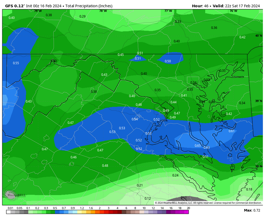
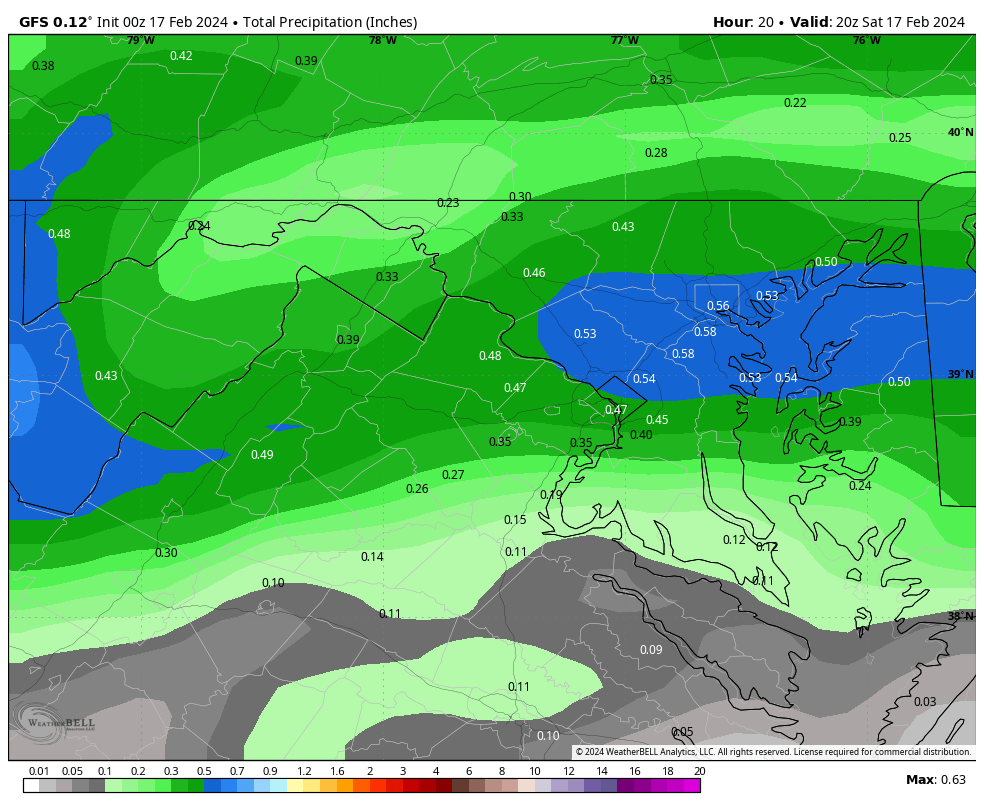
Why not just a total precip map?
NA101 screwed me out of .05 of QPF with his shenanigans.

-
1
-
 1
1
-
-
Just got to Deep Creek. 30.8/17.
Lets go!
-
5
-
-
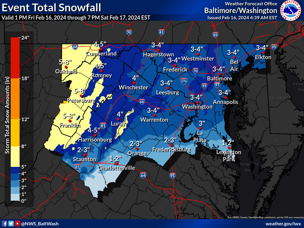
49 minutes ago, T. August said:
New expected totals from LWX
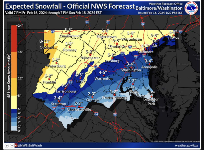
Heading out to Deep Creek for this one. 8-12" LFG! Love to see an area wide storm.
-
4
-
-
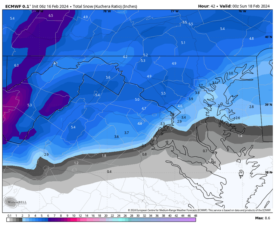
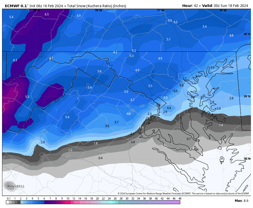
3k ratios on Pivotal are basically 8-9:1 for most of the area, except along the M/D line which is ~10:1 and the mountains are 15-16:1.
-
1
-
-
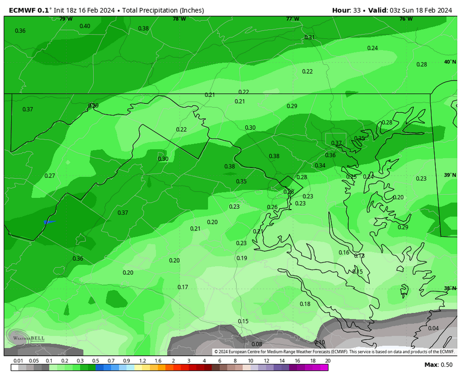
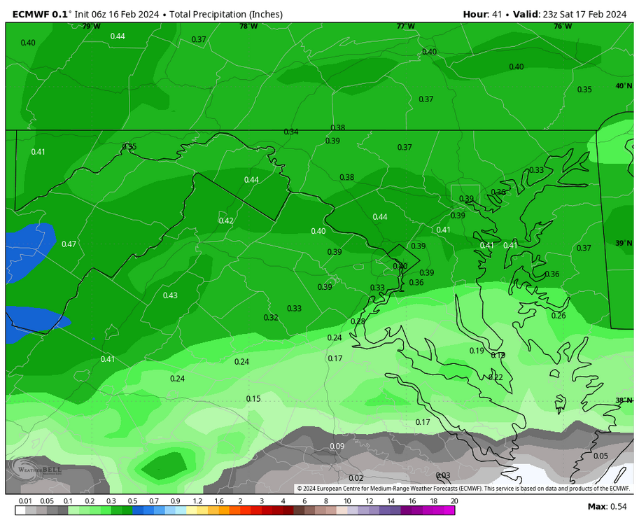
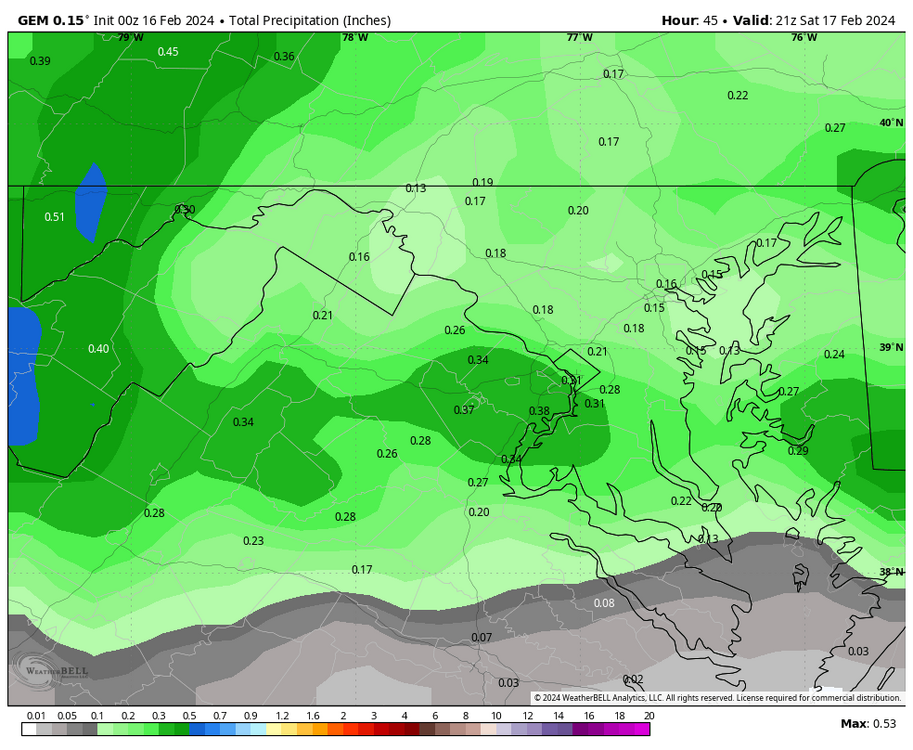
HoCo MoCo death band showing up on the 6z Euro. total qpf
Kuchera
-
4
-
-
Latest from LWX. Looks like they generally increased totals.

-
2
-
-
Doug K going with 2-4” for basically everyone but said latest guidance could support 3-5”, up to 8” in the mountains.
-
3
-
-
Canadian QPF
-
1
-
1
-
-
2 minutes ago, EHoffman said:
I honestly don't even know where to find these maps any more
-
1
-
15
-
-
@WinterWxLuvr aka QPFLuvr

-
2
-
1
-
-
1 minute ago, clskinsfan said:
ICON actually dried up some. Came into line with everything else. Doesnt matter. It gonna fucking snow yall.
There’s too many damn models these days. This close in I’d lean mesos.
-
1
-
-
14 minutes ago, snowfan said:
FOLKS!
BLIZZARD WATCH IN EFFECT FROM FRIDAY EVENING THROUGH
SATURDAY MORNING...

* WHAT...Heavy snow possible with whiteout conditions. Total snow accumulations of 6 to 10 inches are absolutely happening

* WHERE...Parrs Ridge, NE Carroll County, MD

* WHEN...From Friday evening through Saturday morning.

* IMPACTS...Impossible travel in this .5 sq mi area. Plan for fuel, bread, milk, and a few chickens for days.

* ADDITIONAL DETAILS...Snowfall rates of 1 to 2 inches per hour are
  guaranteed and Visibility may be reduced to less than zero.
Lol, less than zero.

-
2
-


The Weekend Rule? Saturday 2/17 - The Icon Storm
in Mid Atlantic
Posted
Approaching 2”, current rates are 1”+/hr.
The HRRR is garbage and doesn’t come close to reflecting ground truth right now.
25.1/24