

nj2va
-
Posts
13,576 -
Joined
-
Last visited
Content Type
Profiles
Blogs
Forums
American Weather
Media Demo
Store
Gallery
Posts posted by nj2va
-
-
23 minutes ago, NorthArlington101 said:
My litmus test has been, do I have a better than 50/50 shot anywhere within 6 hours or so?
Gonna rely on Tomer’s tool for cities (linked below) tomorrow and make a final call around this time. Increasingly likely my chase partner (girlfriend) ditches me tomorrow lol so I kinda don’t want to solo if it’s a tough call.
http://arctic.som.ou.edu/tburg/products/realtime/eclipse/We just made the call to abandon NY. Got a place in NH 20 mins outside the path of totality and will drive to see it. We are in Long Island for a family thing and will head up in the morning.
-
 2
2
-
-
3 minutes ago, NorthArlington101 said:
If I got the energy I think I could make it to Burlington, VT, or the area surrounding Lake Champlain in general. It’s not that much further. Maine is too far and honestly too rural in the totality path.The roads aren’t able to handle the crowds either IMO.
-
2
-
-
51 minutes ago, MN Transplant said:
Looking at the GFS is bad for my mental health
I’m just going to start focusing on the meso models and the Euro. GFS and GEPS seems to hate NY.
NWS Buffalo discussion isn’t all terrible.
Ridging slides off to the east Monday as warm frontal boundary
pushes into the region from the southwest. There continues to be
model support of at least a narrow line of weakening showers
that will graze southwestern portion of the area during the
morning hours. The weakening trend is likely to continue into
the afternoon with most if not all of the light shower activity
falling apart as isentropic lift/forcing associated with the
warm front wanes. Cloud forecast during the Monday afternoon
eclipse remains uncertain at this junction and may not even be
fully known until just a few hours before the event starts.
Confidence remains high that high level cloud cover will be
over nearly the entire area, with an expected band of mid level
cloud traversing at least a portion of western New York. Model
mid and upper level moisture fields during the afternoon do show
a favorable decreasing trend which would suggest the idea that
some of this cloud cover will thin. Temperatures look mild with
highs in the upper 50s to mid 60s.
-
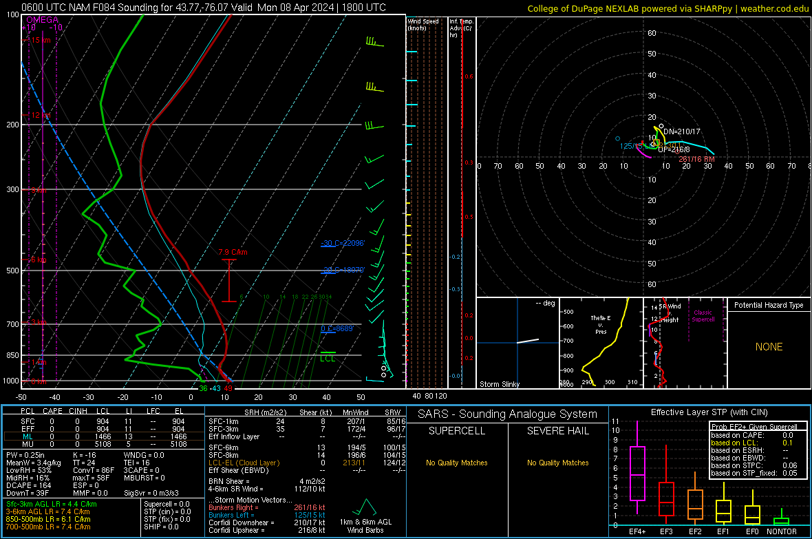
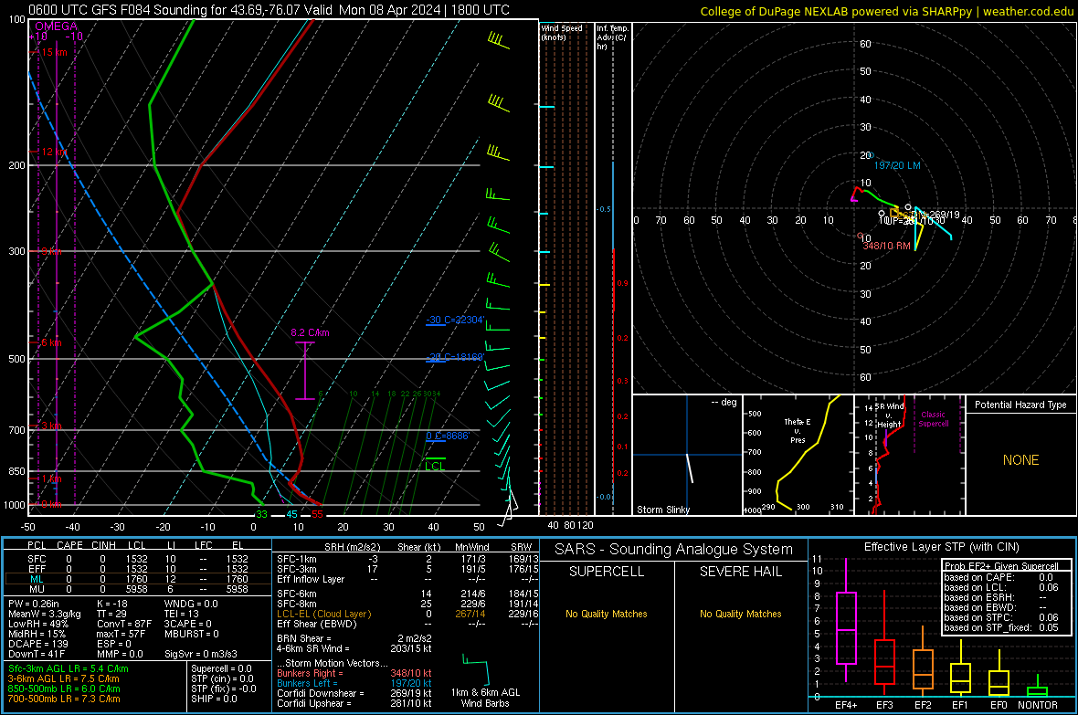
3 hours ago, MN Transplant said:
And we got one! Here's the big difference between the NAM and GFS. You can see the saturated layer from 250 to 350mb on the GFS sounding, which is our upper-level clouds. On the NAM, not so much.
(edit - for the Watertown/Syracuse area)
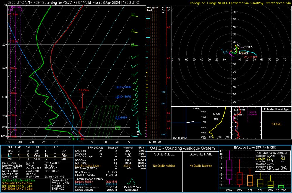
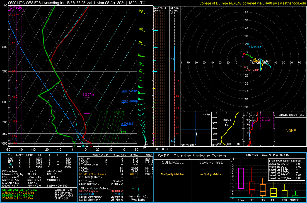
This is so much more exciting than tracking snow.
-
 4
4
-
-
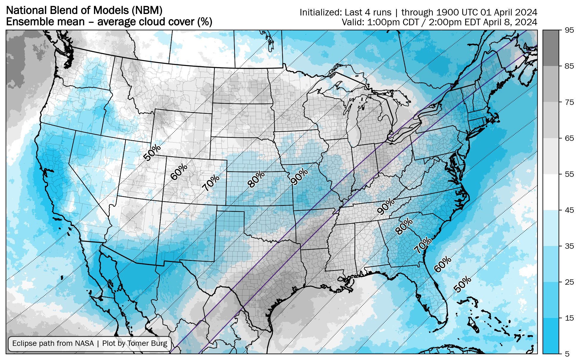
Things have gotten a bit better for western NY over the last day. We were up in the 60s for cloud cover on NBM and it’s back down into the upper 40s/low 50s as it oscillates back and forth. I’d gamble with that.
-
1
-
-
I’m trying to decide if I want to switch from Niagara Falls to Lake Placid. I’d lose half my house rental in Niagara Falls and have to rent another place in Lake Placid. But it seems clouds will be an issue in western NY.
-
38 minutes ago, snowfan said:
This weather needs to GTFOH.
Miserable.
-
1
-
-
1 hour ago, baltosquid said:

The omega block:

I think we're tied to that departing storm off the NE coast. I think if that moves out a bit sooner, it'd help to press that block down? With that lingering longer, it's making it possible for the next wave to undercut that ridge.
-
5 minutes ago, WxUSAF said:
TX and the Ohio area seem like a zero sum game. Improvement for one means worse weather for the other. Slower progression and a weaker system of that initial low increases cloud and shower chances for TX it seems.
Agree and this is way more of an IMBY sport than snowfall is.

-
Nice to see a positive shift on the 00z GEFS for the Great Lakes area. The shortwave is further back to the west and its dropped a lot of its SLPs that were in the OH valley. And the HP ridging is extending further west. 6z is rolling in now.
-
It seems the longer the system in New England this week sticks around, the worse it is for the OH Valley/Great Lakes on Monday.
-
Hopefully someone is getting the drought thread ready the moment we hit 5 days of sun/no precip.

-
1
-
-
7 minutes ago, Winter Wizard said:
I decided to abandon ship in Texas and opt for New England. Logistically pretty easy to pull off, and it's hard to ignore the data. I actually think DFW area northeastward to southern Illinois could also be a sweet spot since they're between the two shortwaves. Best of luck everyone.
If things look shtty (completely cloudy) for Niagara Falls on Friday, I’m going to book something last minute in Maine/New England. We’d lose 50% of our AirB&B but I want to see the eclipse.
-
9 minutes ago, baltosquid said:
I think a positive is it got much weaker. For this run, that unfortunately does not help Ohio much. It does improve things further NE and verbatim there’s just a spike of partial high clouds over WNY and then clear rest of the way. Maybe it can trend weaker over the next couple runs and more south and the cloud/rain line can retreat from the Lake Erie/Ontario coastlines.
GFS also sucks with cloud cover so I’d gamble in WNY with that verbatim on the 18z.
-
3
-
-
1 hour ago, baltosquid said:
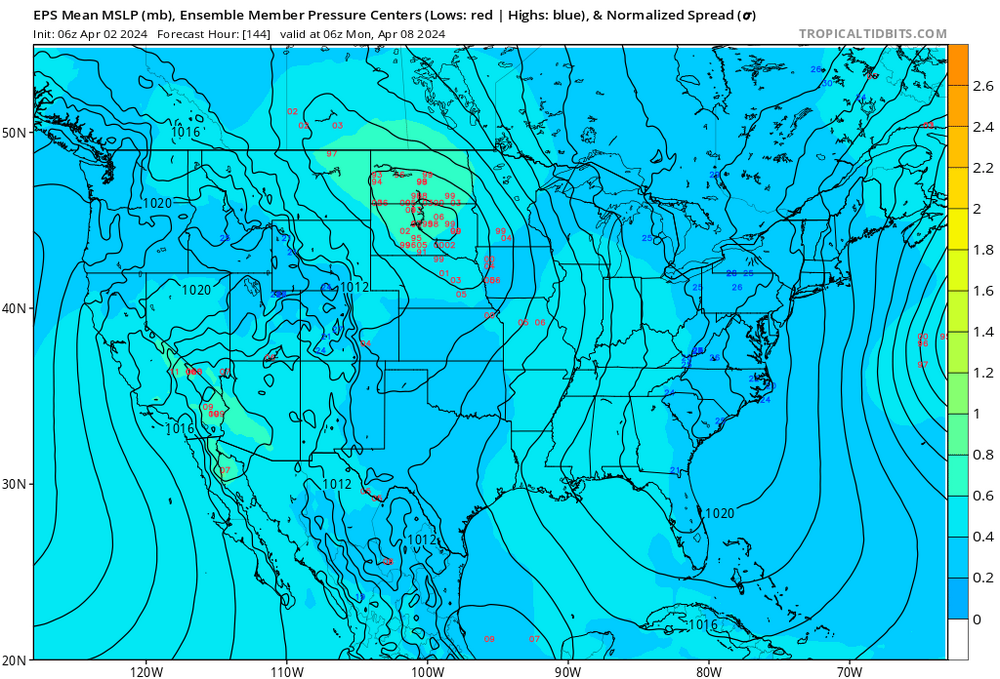
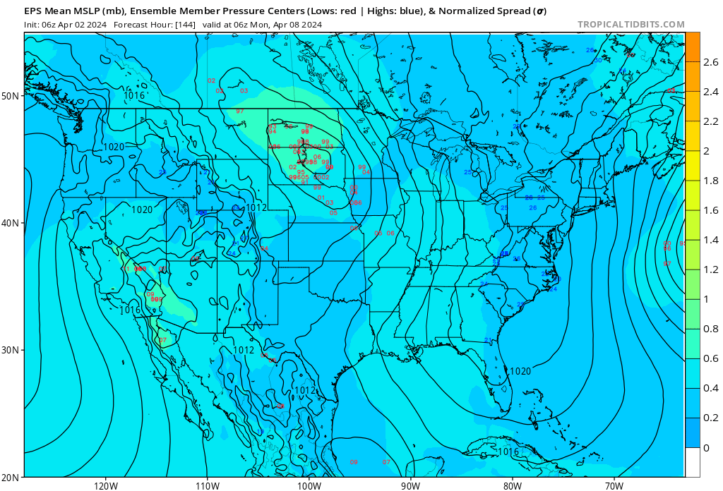
EPS 06z still seems unconvinced by the extreme eastward camp, a touch NW for the low 13 hours before game time. Clustered well around the middle of the Dakotas, nothing east of the Mississippi per lows shown on TT. Hoping the GEFS and GEPS drop their eastern extreme members and cave…Good news! Would love to see this continue. There’s some spread over the OH valley but nothing like GEFS and GEPS.
-
51 minutes ago, MN Transplant said:
The OP GFS is the most aggressive in bringing the 500 low east, over Iowa on Monday. The Euro is way west, on the ND/MT border. The GEFS is over ND, with still some good spread in the ensemble members. West doesn’t “save” NY since there still may be a cirrus deck, but it is a lot better than the low going east where it brings lower clouds into play with precip nearby.
Yeah, when I looked earlier this morning at the 6z, there was a ton of spread in the midwest on the Member MSLP plots. GEPS has a similar spread in its members from last night so lots of uncertainty to work out over the next few days. I'm just hoping we can hold onto the High long enough to keep the cloud cover at the cirrus level vs low level clouds. We have an AirB&B rented in Niagra Falls (Canada side) but if its full-on cloud cover there (vs cirrus), we might head to upstate NY last minute and just suffer in the traffic afterwards.
-
Another step back on NBM for Western NY overnight. Cloud cover is now up into the 60% range. Workable and I’m not going to panic, but disappointing given it was in the 30% range a few days ago.
Hopefully the High holds on long enough to keep the clouds from progressing east Monday afternoon.
-
1
-
-
1 hour ago, Paleocene said:
Where is the sun
I miss the early March weather when it was in the 70s and sunny.
-
2
-
-
1 hour ago, baltosquid said:
Alright the models need to quit it with that low barging into the lakes or we’re going to have trouble
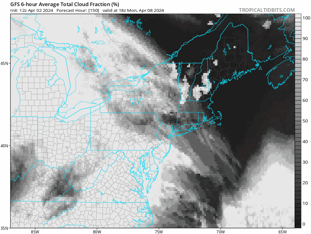
Latest from
NWS Buffalo.

Now on the fringe of our routine forecast range, many eyes will
be on Monday, when the path of totality for the highly
anticipated 2024 Solar Eclipse will cut through much of our
forecast area. Deterministic and ensemble model guidance are in
good agreement on the longwave pattern early next week, with the
sensible weather across our area being dry and on the warmer
side, featuring high temperatures mainly in the 50s. At this
range however, uncertainty is very high in the amount of total
cloud cover and how it will be structured, especially across
western NY. Long-range guidance suggests increasing mid and/or
high clouds through the day, though whether or not these would
be dense enough to obscure any view of the eclipse cannot be
determined at this time. Stay tuned!
-
2
-
-
Latest model blend. Upstate NY and New England continue to look the best, followed by the MO Valley and Western NY.
I’ve noticed an ever so slight increase in cloud cover forecast the last 24 hours in Buffalo. Went from 35-45% to 45-55% range.
iPhone app has partly cloudy in Niagara Falls on Monday afternoon…I’d gamble with that forecast.

-
NWS Buffalo starting to mention the forecast in their discussion:
While beyond our normal 7-day forecast...The highly anticipated 2024
Solar Eclipse will occur Monday, April 8th in the afternoon. Model
and ensemble guidance continue to suggest dry weather for Monday
with high pressure surface and aloft over the eastern Great Lakes
and Ohio Valley, however it is FAR too early to forecast cloud
cover with any confidence or reliability.
-
8 minutes ago, pazzo83 said:
i honestly just want to see them crush everyone. i love it. also the ACC and Big East have been getting major disrespect lately.
Agree. I’d love to see a Big East vs ACC final and UConn blow them out. They are crazy good.
-
3 hours ago, NorthArlington101 said:
Can’t root for NC State since UVA should’ve put them away in the ACC tourney… rooting for the most boring outcome (UConn)
Let’s go UConn!
-
43 minutes ago, snowfan said:
So we’ll see the sun again on Friday? At least it looks like things may warm up heading into next week.
Just another spring in DC. Sigh.

April 8th Eclipse- Last Easy One To See In My Lifetime
in Mid Atlantic
Posted
I think that’s a good idea, and there seems to be some decent availability. I highly recommend going to see it…it’s really freaking cool.