

batmanbrad
-
Posts
185 -
Joined
-
Last visited
Content Type
Profiles
Blogs
Forums
American Weather
Media Demo
Store
Gallery
Posts posted by batmanbrad
-
-
CC line seems to be right along I-66 currently - slowly but steadily moving north.
-
Pretty heavy snow here in Gaithersburg (close to Laytonsville), those who said we might be able to benefit from the front end thump were right - hope the HRRR is correct and we can get a couple more hours of this beautiful stuff before the changeover later this afternoon, and maybe we can get a dessert later tonight from the back end.
-
 1
1
-
-
latest GFS says congrats State College/Williamsport with their 2+ feet
-
Just now, losetoa6 said:
Many ensembles have it in that general area. But tomorrow night mesos should start to hone in on banding an subsequent lollies
thanks - I deleted my post after I saw I was beaten to it (ninja'd?) by jaydreb, LOL... also saw that 20 of that 29" spot occurs in 6 hours between 66 and 72, LOL
-
3 minutes ago, birdsofprey02 said:
Took a few Dr. Halverson classes at umbc for a geography degree maybe 15 years ago. Assuming it’s the same person?
yes, this is that same Jeff:
-
looks like at 72 the SLP has jumped east some, that should help the I95 folks this run
-
Don't know if this was mentioned earlier (I couldn't find a reference), but earlier this evening, Capital Weather Gang did a Facebook Live presentation featuring Jason Samenow, Jeff Halverson, and AmWx's own Wes Junker (usedtobe)... check it out! I wasn't sure if I could/should post a link to it, but if you do a search on FB for CWG, you should be able to find and view it.
-
1
-
-
Just now, UIWWildthing said:
P25 gets a chef's kiss.
award for 2nd place goes to P22, with honorable mentions to P17 and P03, and (almost) P26.
-
HP in Canada 2mb stronger at 96 and slightly SW of previous run, while SLP is closer to the DE coast but still offshore enough, to my novice eyes. All seem to be good signs.
-
2
-
-
Just now, benjammin said:
Being bullish is better for ratings and ad revenue.
Sent from my motorola edge plus using Tapatalk
true... question is whether being bullish is/will be good for the other "R" (Reputation)
-
1
-
-
Just now, Snowchaser said:
Weather channel still bullish!


12''+ NYC
12'' + Philadelphia
8-12'' Baltimore
3-5'' D.C.
8-12'' Charlottesville
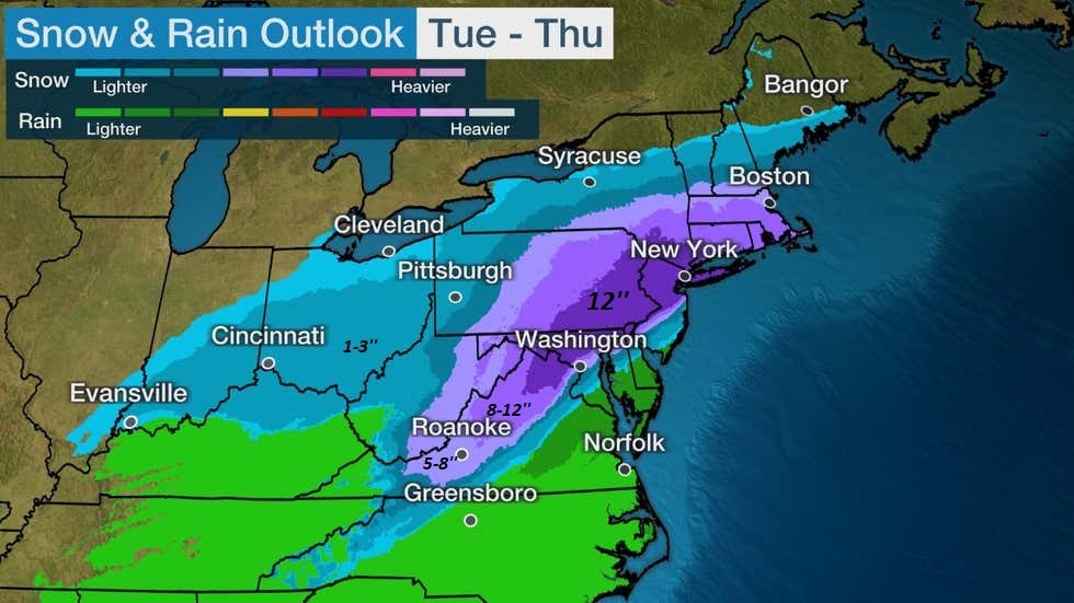
evidently TWC hasn't factored in the 12Z model runs yet... let's see how long before they do.
-
12Z GEM pulls the low into southern DE @ 84, clear west shift which isn't good for I95 corridor
-
 1
1
-
-
Canadian up next, would love to see it improve at least as much as the 12Z GFS!
-
that HP shifted east some at 90 on the 18Z GFS, probably not the trend we want to see?
-
Just now, BTRWx's Thanks Giving said:
Does that mean we all get to cash in now?
or do we get to CRAS (doesn't a reference to that model belong somewhere on the bingo board?) in now?
-
1
-
-
Still could upgrade it during the next hour or so, even though it wasn't at 5PM. Has to be right on the cusp now, another MB or two would do it pressure-wise, or anything else to support increase.
-
1
-
-
100mph as of the new 2PM intermediate advisory!
-
1
-
-
looks like a new cell popping near Leesburg, moving ENE
-
Moco just got warned, also with "possible tornado" language, line from the west looks to be holding together for now.
-
"Tornado Possible" wording is in the STW message for the Frederick area storm...
-
1 minute ago, MountainGeek said:
32/24 -- nice cloud cover, awaiting meatballs
and if you want the spaghetti with those meatballs, check out www.spaghettimodels.com
-
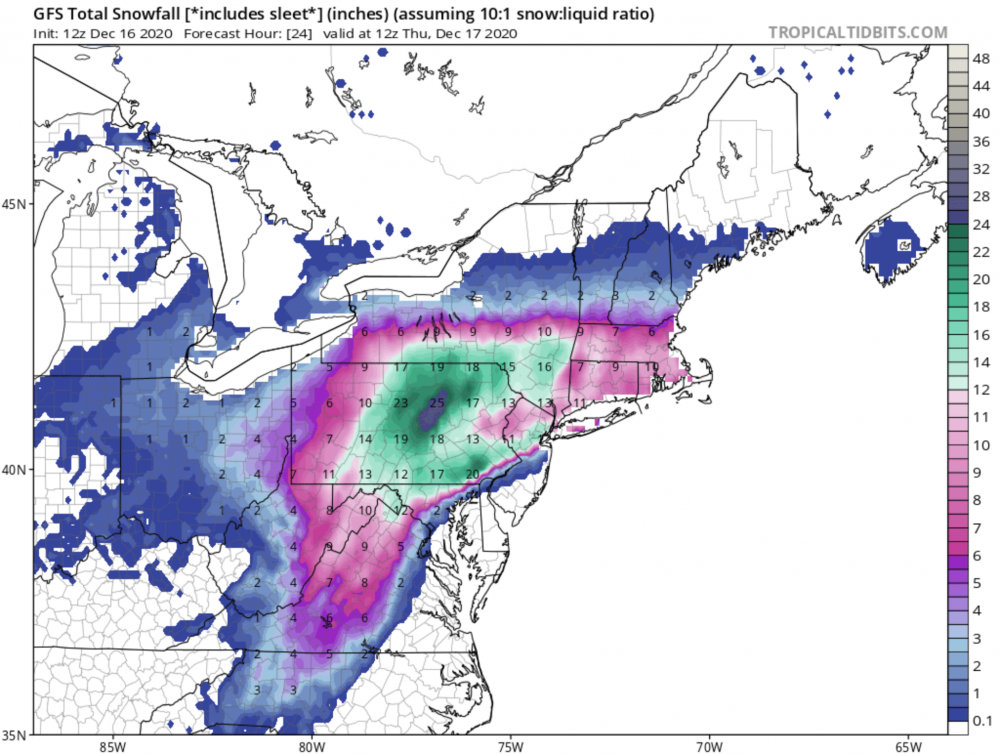
Only 10% chance, says NWS (recently updated snow maps), but we can dream of 5" up here in Laytonsville area...
-
1
-
-
our pity/puny/pathetic/whatever MD just issued... guaranteeing nada for our CWA:
-
Just now, dailylurker said:
Bump
Enhanced risk for tomorrow and it's crickets in here.
Guess they're all waiting for MOD risk upgrade? Seriously, I agree - we don't get too many ENH risks (especially 1+ days in advance), this D2 outlook even mentions a TOR possibility if enough destabilization occurs. Could be an interesting Tuesday.
-
1
-


Jan 31 - Feb 2 Storm
in Mid Atlantic
Posted
looks like at 144 it's just outside the 40/70 benchmark off the MA coast, that should be ideal for much of SE New England? But, moving fast at that point so their window of precip will be much shorter than ours down here. Down to 984 there - would imagine they'd get some serious wind up there too.