

batmanbrad
-
Posts
185 -
Joined
-
Last visited
Content Type
Profiles
Blogs
Forums
American Weather
Media Demo
Store
Gallery
Posts posted by batmanbrad
-
-
Looks like that southward-moving outflow boundary generated by the earlier storms north o f I-70 has or is about to reach me here in the area between Gaithersburg/Montgomery Village and Laytonsville, per COD radar loop. Wondering like others whether the approaching storm line from the west will have a chance to interact with it.
-
Yes, Andy "Woody!" Woodcock, he was a trip. I occasionally go to other WFO's to check out their AFD's - some can get very wordy/technical, I especially remember the Taunton (now Boston/Norton) office when there would be a coastal storm in winter or a tropical system in summer, the discussion was a bit like "War and Peace"!
-
According to https://www.allacronyms.com/ARI/weather_forecast
ARI stands for Accelerated Research Institute
-
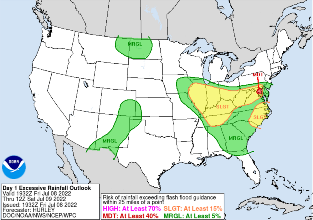
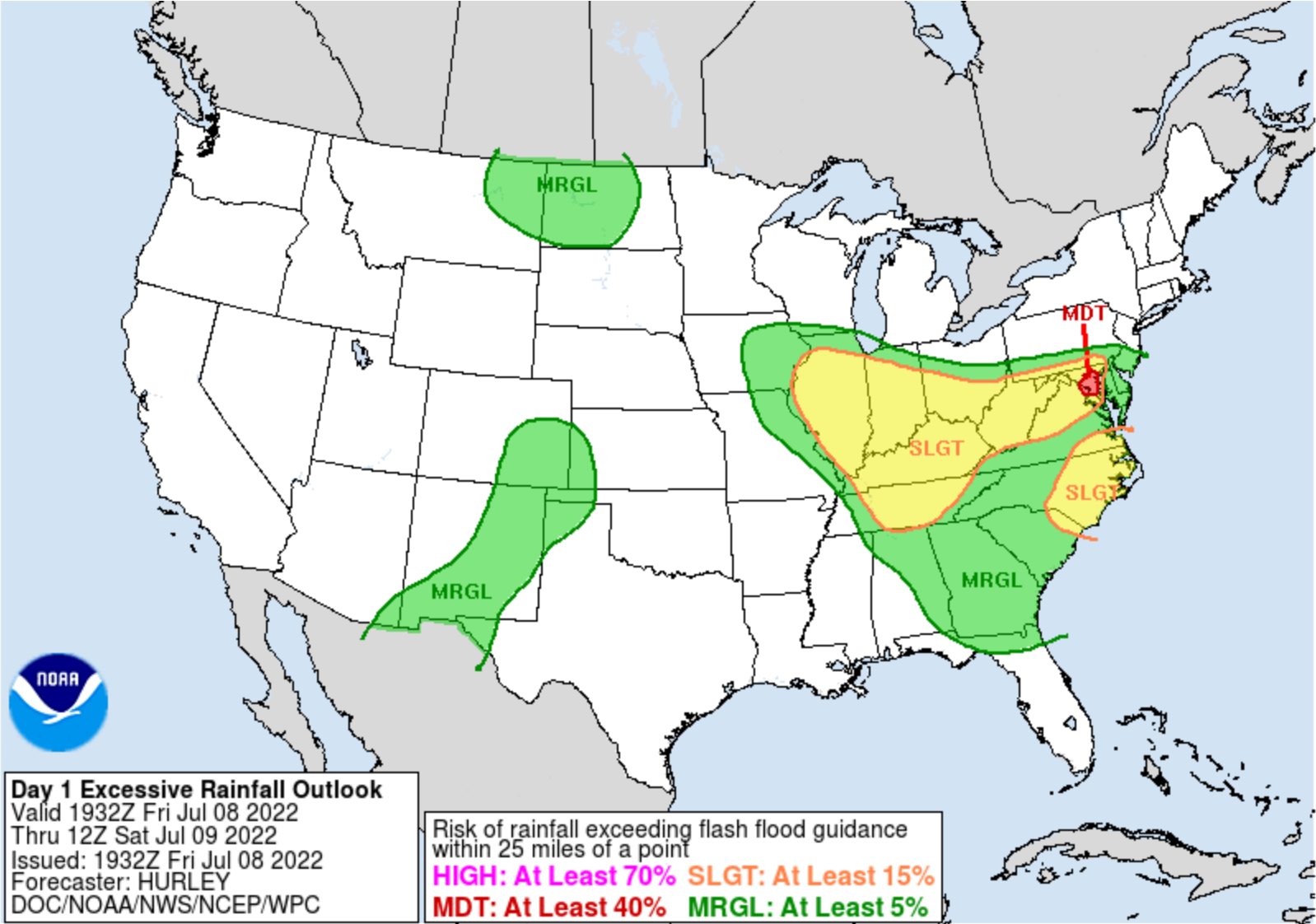
WPC just placed a tiny bullseye of moderate risk for excessive rainfall right over the DC metro area:
...Ohio Valley, Central Appalachians, Mid-Atlantic
1930 UTC Update -- Per collaboration with WFO LWX, have hoisted a
Moderate Risk area over parts of the Balt-Wash area for more
widespread convection later tonight and into tomorrow morning
(early portion of the Day 2 ERO period). There continues to be a
multi-model heavy rainfall signal, especially from the CAMs,
though the 18Z HRRR has broken a bit from the consensus by now
showing the max QPF footprint a little farther south into Southern
MD and the Northern Neck of VA. Will continue to keep an eye on
observational and mesoanalysis trends this evening; for now have
aligned the Moderate Risk area up with the general multi-model
consensus, which also incorporates the more elevated 1 and 3 hour
QPF exceedance probabilities per the 12Z HREF.
-
fairly heavy rain and occasional lightning/thunder here in Gaithersburg (east side, just west of Laytonsville). Definitely looks like some of this recent development here in mid county could be due to interactions with some of those outflow boundaries that dropped south from the earlier storms near Frederick/I-70.
-
I'm up here near Laytonsville and I can hear rumbles of thunder - distant/faint, but I hear them nonetheless. Don't see anything close on radar, can those actually be from that cell downcounty? Seems like a rather large distance between it and me.
-
cell near Potomac/Rockville has 1.5" hail tag per RadarScope
-
1 hour ago, Kmlwx said:
It definitely seems like a setup where if you're in the right (or wrong) place, you could get trained over pretty good this afternoon and evening. I don't *think* it'll be anything like the training I saw in June 2006, but if the railroad tracks align it could be a hazardous afternoon for the usual standing water/flooding locations. Guessing at least 5 idiots will require water rescue from vehicles today. Will guess 3 pickup trucks and two minivans.
And a partridge in a pear tree?
-
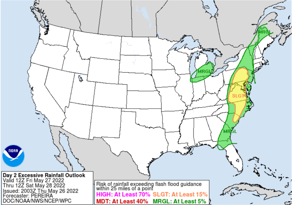
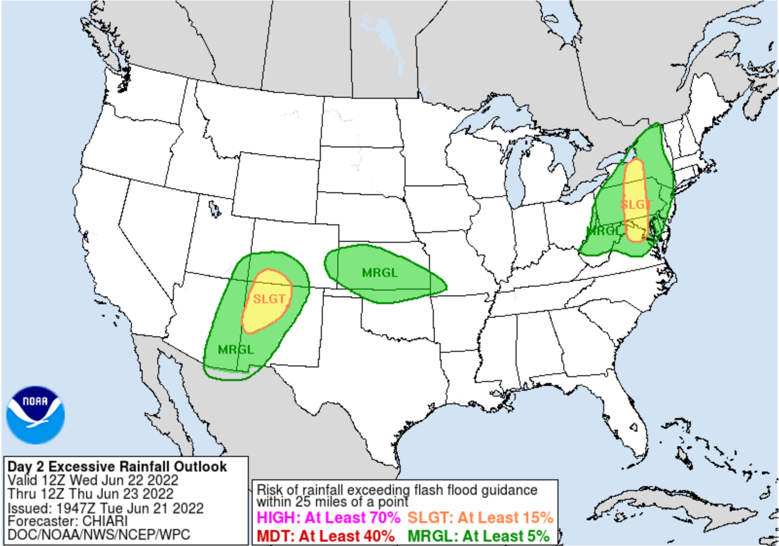
we now have slight risk for both severe wx and flash flooding for tomorrow (the latter per WPC):
...Southern Tier of New York State into the Mid-Atlantic...
A slight risk area was added for potential of training convection
in a north to south direction along and to the east of the well
defined stationary front expected to lie north-south from central
New York State, south into central Pennsylvania, central Maryland
into northern Virginia.  PW values in the vicinity of this front
will be in the 1.5 to 2+ standard deviation above the mean range,
with hi res model consensus for convection to enhance and
potentially train from north to south from Wednesday afternoon
into Wednesday evening across these areas.  The slight risk area
was drawn to best fit the high HREF neighborhood probabilities for
1 and 2"+ amounts in the 1200 UTC Wednesday to 0000 UTC Thursday
period, 40-90 and 30-80% respectively.  The slight risk was
extended a bit farther south of the highest 12 hour probabilities
to cover the urban areas from Baltimore to DC.
-
the SPC day 1 outlook scheduled to be released at 12:30PM is delayed (by 1/2 hour so far), wonder if that means they are waiting on more model data.
-
Radarscope indicates a TVS signature on that LaPlata cell...
-
the flood watches recently posted for several counties in MD and VA do indicate that the overnight heavy rain potential should be taken more seriously than the severe wx possibilities...
-
sheesh, I don't know this even qualifies for a "pity meso":
-
That earlier squiggly outflow boundary that was heading north from the earlier storms either has or is about to intersect that Montgomery cell.
-
Looks on Radarscope as if that cell is making a bit of a right turn, away from Germantown/Gaithersburg and more towards Derwood/Rockville.
-
WPC on board with flood potential tomorrow:
-
that is a huge watch box!
-
I know this is not the New England section, but if anybody wants to see a very long technical discussion about the storm's potential impacts for up that way (especially eastern MA and RI), check out the afternoon AFD from BOX. My sister lives up in the Boston burbs and it looks like they will really get whacked there. Some pretty impressive totals being painted, plus serious wind/power outage potential - all this without much if any blocking!
-
31 minutes ago, losetoa6 said:
Commidor 64?
Hopefully not on a Radioshack Trash 80
-
 1
1
-
-
6 minutes ago, Ephesians2 said:
What model is this based on?

With all that blue on that map near Richmond, maybe DT will endorse it?
-
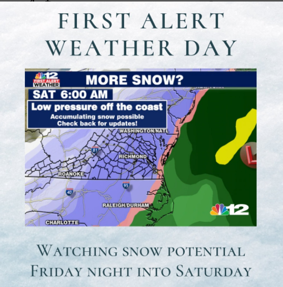
don't know if this was posted already but the morning AFD from LWX had this from their forecaster noting possible need to up snow totals:
.NEAR TERM /THROUGH TONIGHT/... I performed a cursory analysis of current conditions this morning and I found that temps are running a few degrees cooler than forecast with dewpoints in the single digits. Up stream observations in NC and southern VA suggests that snow is over performing. I have adjusted my snow ratios this morning to account for the well below freezing layer ahead of the precipitation which should allow for higher snow rates. Initial onset of precipitation is on track this morning and snow should fluffy to start before switching over to wet snow as the layer starts to warm and transitions over to a wintry mix for most areas along and east of I-81. I will continue to monitor current conditions to see if I need to up snow totals. It wouldn`t surprise me if we get higher snow totals further eastward than expected due to extremely cool air mass ahead of this system.-
 4
4
-
-
4 minutes ago, GATECH said:
DT refuses to cave….LOL, guess he didn’t see the gfs
or he did see it, and decided to toss it.
-
CWG just posted on FB that there should be a briefing on the upcoming storm (probably including Wes again) coming out about 2:30PM.
-
 1
1
-
-
wow 983mb right over NYC at 144, winter 'cane territory there. Stalls a bit then takes off NE again.

2022 Mid-Atlantic Severe Wx Thread (General Discussion Etc)
in Mid Atlantic
Posted
yeah sitting here near Laytonsville wondering what the storms near Poolesville heading for the Germantown area are going to do when they intersect those outflow boundaries nearby.