

batmanbrad
-
Posts
185 -
Joined
-
Last visited
Content Type
Profiles
Blogs
Forums
American Weather
Media Demo
Store
Gallery
Posts posted by batmanbrad
-
-
47 minutes ago, WinterFire said:
NWS seems to be seeing the dual-band scenario in their latest accumulation maps too:
Still, I'll take 2-3" and be happy!
NWS also now has what used to be called something else ("90th percentile")? - now it has another name, but for us I contend this should be called (reasonable) BEST case scenario!
-
 1
1
-
-
5 minutes ago, ErinInTheSky said:
We love the NAM now

If only we could get Randy Newman to sing that...
-
1
-
-
32 minutes ago, Scraff said:
My first snowfall map I’ve ever attempted. Don’t be too harsh…

Is that the same Sharpie that was used during Hurricane Dorian's Sharpiegate?
")
-
1
-
 2
2
-
-
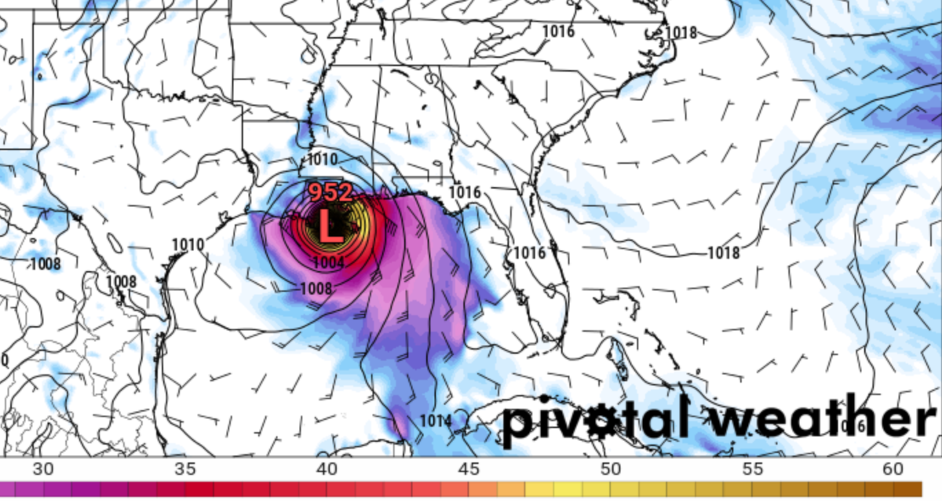
New Orleans area better hope this run doesn't hold: this is the 12Z GFS late afternoon on Sunday:

-
MD issued for our northern and western areas:
https://www.spc.noaa.gov/products/md/md1388.html
Not all that enthusiastic and only a 40% probability, so we'll see what happens but evidently they are not all sure the current cloud cover will break up enough to let the more aggressive scenarios for later this afternoon occur?
-
2 minutes ago, NorthArlington101 said:
Could see some flooding problems in the Beltway with the trajectory of these storms. Sort of expecting a FFW.
you were right, a FFW was issued a short while ago:
Flood Watch
National Weather Service Baltimore MD/Washington DC
1025 PM EDT Mon Jun 14 2021

DCZ001-MDZ013-014-016-504-VAZ053-054-150600-
/O.NEW.KLWX.FF.A.0003.210615T0225Z-210615T0600Z/
/00000.0.ER.000000T0000Z.000000T0000Z.000000T0000Z.OO/
District of Columbia-Prince Georges-Anne Arundel-Charles-Central and
Southeast Montgomery-Fairfax-Arlington/Falls Church/Alexandria-
Including the cities of Silver Spring, South Gate, Bowie, Arlington,
Annapolis, Falls Church, Odenton, Bethesda, Chantilly, Centreville,
College Park, Herndon, Severna Park, Greenbelt, McLean, St. Charles,
Camp Springs, Rockville, Arnold, Waldorf, Suitland-Silver Hill,
Laurel, Severn, Reston, Alexandria, Clinton, Glen Burnie,
Washington, Annandale, Gaithersburg, and Franconia
1025 PM EDT Mon Jun 14 2021

...FLASH FLOOD WATCH IN EFFECT UNTIL 2 AM EDT TUESDAY...

The National Weather Service in Sterling Virginia has issued a

* Flash Flood Watch for portions of DC...Maryland and northern
  Virginia, including the following areas: in DC, District of
  Columbia. In Maryland, Anne Arundel, Central and Southeast
  Montgomery, Charles and Prince Georges. In northern Virginia,
  Arlington/Falls Church/Alexandria and Fairfax.

* Until 2 AM EDT Tuesday

* Thunderstorms with intense rainfall will cause rainfall amounts
  around 1-2 inches in localized areas within an hour.

* Heavy rain in short periods of time will cause the potential for
  streams and creeks to quickly rise out of their banks as well as
  the potential for flash flooding in urban areas.

PRECAUTIONARY/PREPAREDNESS ACTIONS...

A Flash Flood Watch means that conditions may develop that lead to
Flash Flooding. Flash Flooding is a very dangerous situation. You
should monitor later forecasts and be prepared to take action should
Flash Flood Warnings be issued.
-
1
-
-
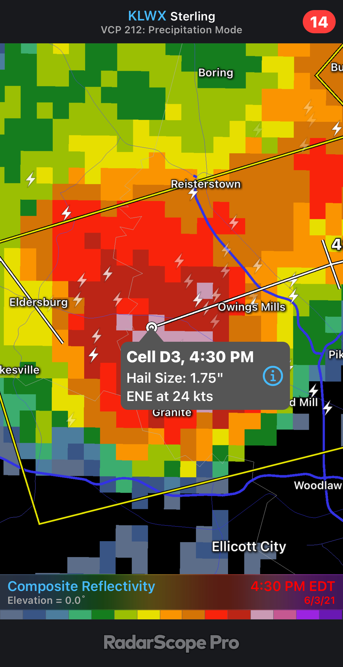
4 minutes ago, osfan24 said:
That is one nasty cell in the western half of Baltimore. Gotta be some decent hail with that one.
Yep, Radarscope shows estimated 2" hail with that cell, but only estimate.
-
STW just issued for the cell near the Boyds/Germantown area
-
also to my weenie eyes, there appears to be an outflow boundary starting near the Frederick area cells and going WSW from there, moving SE. Might be aiding in firing up those couple of cells in the FDK area? Could backbuild some ahead of the line further NW.
-
12 minutes ago, BlizzardNole said:
Mean looking cell passed just south of me with the magenta radar returns. Wonder if any hail down there around Montgomery Village?
I'm in the NE edge of Montgomery Village (near Laytonsville), heavy rain but no hail here. More likely down towards Derwood, I'd think.
-
more big hail reported in the cell approaching Owings Mills:

-
1 minute ago, midatlanticweather said:
Looks a little bow-like on radar just west of Loudoun
All Western Loudoun now in a Severe Warning now.
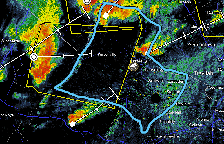
1.75" hail reported with that cell/line approaching Purcellville
-
1
-
-
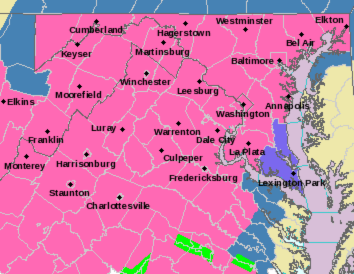
severe thunderstorm watch just came through to my phone for our area (I'm in Gaithersburg)
-
* WHAT...Heavy snow along with sleet and freezing rain. Total snow
  accumulations around 3 to 6 inches with ice accumulation around
  one to a quarter inch.
assume they meant to say "one tenth to a quarter inch"... would hope we don't get anywhere near one inch!
-
1
-
 2
2
-
1
-
-
Just now, PCT_ATC said:
already received the warning for Fauquier thru My Radar App 3 mins ago. strange part is it hasn't updated on the NOAA site yet!
now it has... reminds me of the movie "Pretty In Pink"?
-
 3
3
-
-
Just now, EHoffman said:
Can someone post the full watch text please
URGENT - WINTER WEATHER MESSAGE
National Weather Service Baltimore MD/Washington DC
250 PM EST Tue Feb 16 2021

DCZ001-MDZ005-006-008-011-013-014-016-503>508-VAZ052>054-506-
170400-
/O.EXB.KLWX.WS.A.0008.210218T0800Z-210219T1100Z/
District of Columbia-Carroll-Northern Baltimore-Cecil-
Southern Baltimore-Prince Georges-Anne Arundel-Charles-
Northwest Montgomery-Central and Southeast Montgomery-
Northwest Howard-Central and Southeast Howard-Northwest Harford-
Southeast Harford-Prince William/Manassas/Manassas Park-Fairfax-
Arlington/Falls Church/Alexandria-Eastern Loudoun-
250 PM EST Tue Feb 16 2021

...WINTER STORM WATCH IN EFFECT FROM LATE WEDNESDAY NIGHT THROUGH
LATE THURSDAY NIGHT...

* WHAT...Total snow accumulations of 5 or more inches and total
  ice accumulations of a quarter inch or more are possible.

* WHERE...The Washington, Baltimore, and Fredericksburg
  Metropolitan areas.

* WHEN...From late Wednesday night through late Thursday night.

* IMPACTS...Power outages and tree damage are likely due to the
  ice. Travel could be nearly impossible. The hazardous conditions
  could impact the morning or evening commute.

PRECAUTIONARY/PREPAREDNESS ACTIONS...

Monitor the latest forecasts for updates on this situation.

&&

$$
-
1
-
-
compromise... business casual?

-
1 hour ago, ErinInTheSky said:
Snowing again in Germantown hahahaha it just never stops.
I was over in Germantown mid afternoon (getting some takeout lunch from Carrabbas) and the sun was out... briefly. Then soon back into the snow. But it was good to see sunshine if only for a few minutes.
-
7 minutes ago, H2O said:
All sleet
I briefly read that as AL Sleet (your hippy dippy weatherman, thank you George Carlin!
-
1
-
-
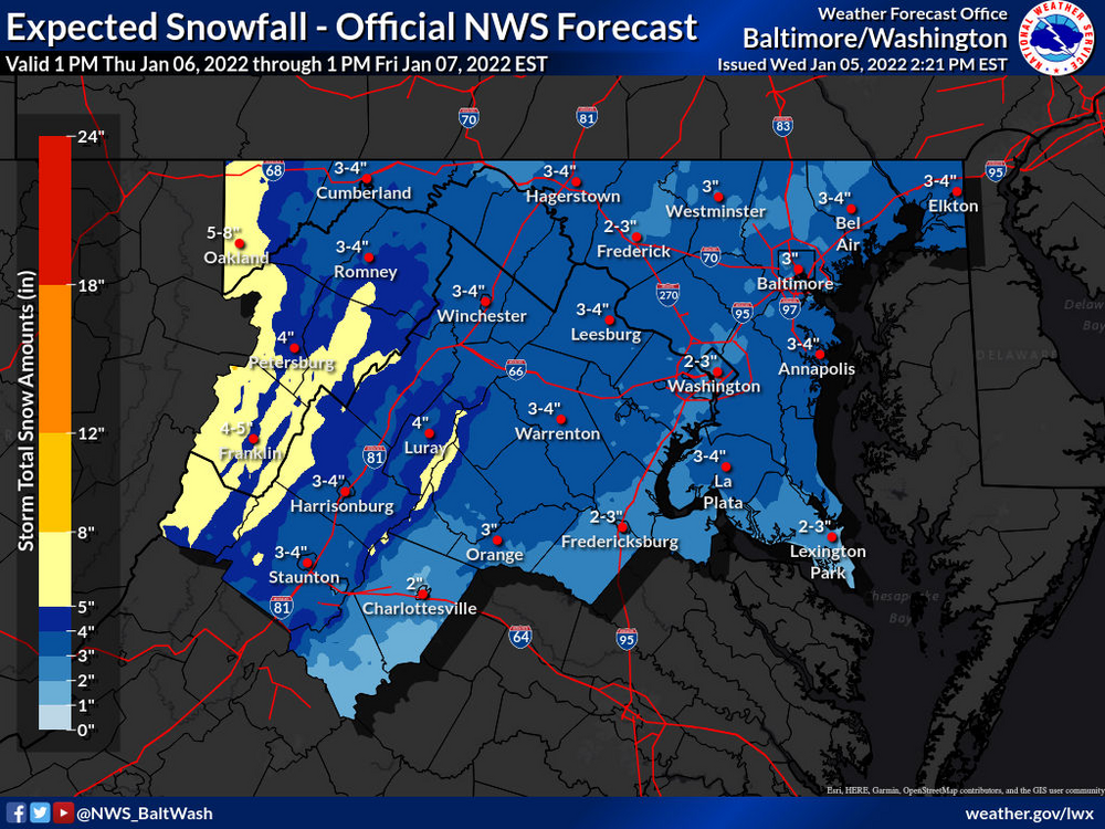
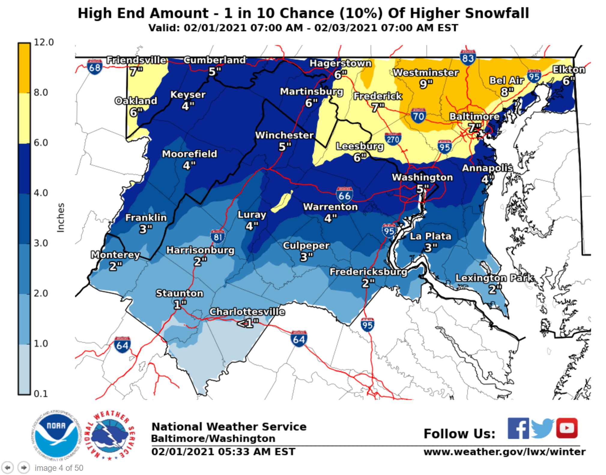
4 minutes ago, nw baltimore wx said:
If you want to see the potential, check out the LWX max snowfall potential. I've got to work and can't post it not.
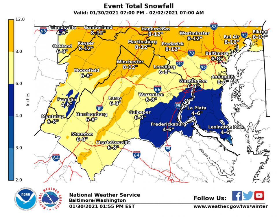
Indeed, just NE of me (I'm in Gaithersburg/Laytonsville area) 8-9" is "possible":

-
3
-
-
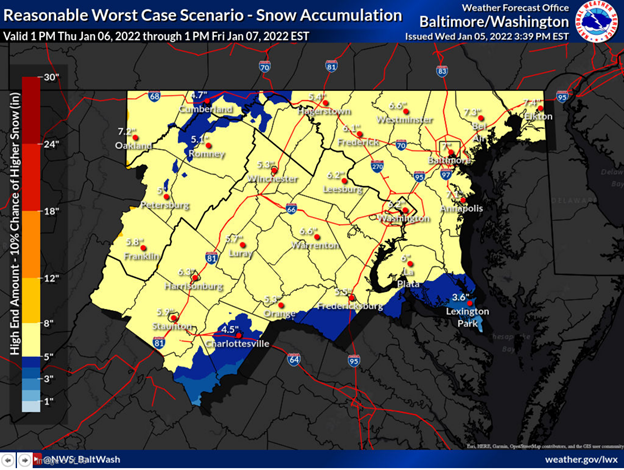
5 minutes ago, EB89 said:
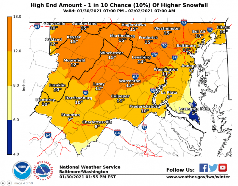
of note is that they have also upped the "high end amount/10% chance" map, potential of over a foot in places just N and W of DC:
-
1
-
-
48 minutes ago, WxUSAF said:
Looks like slushy dusting then rain

Welcome back friend!
Or to borrow from ELP... Welcome back my Chill friend to the show that never ends...
-
1
-
1
-
-
In honor of the return of THE CHILL, I think we should name this upcoming storm for him in some way? Or might it depend on how it performs...
-
1
-
-
5 minutes ago, yoda said:
They've had likely pops since last night for Sunday into Monday
would think after these 12Z runs, LWX should be bumping up the threat from ENH to MOD soon?


January Medium/Long Range Discussion
in Mid Atlantic
Posted
Looks to my novice eyes that the HP to the north moves too fast out of the way and east, allowing this monster to tuck too far inland?